You or someone using this computer or device previously created Trip Plans.
What should we do with these plans?
Make these Trip Plans part of my account
Discard these Trip Plans
Login
Some text here
Password Reset
Please enter the email you used to set up your account.
We'll send a link to use to reset your password.
Check Your Email
If there is an account with the email address , we will send you a link to reset your password
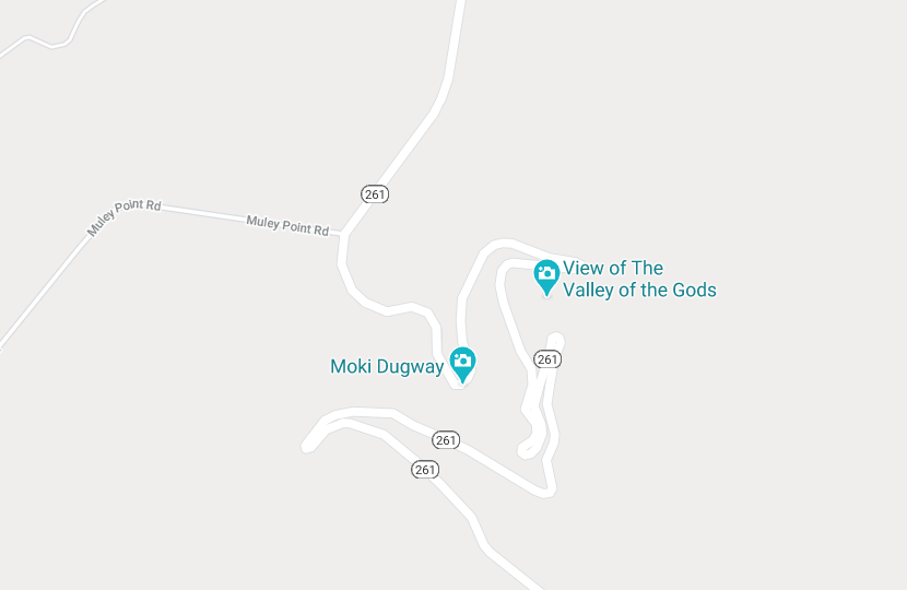
Moki Dugway - Utah Highway 261
The Moki Dugway Scenic Backway, located in Southeastern Utah in the United States, is a remarkable and dramatic stretch of road that runs along Utah Highway 261.
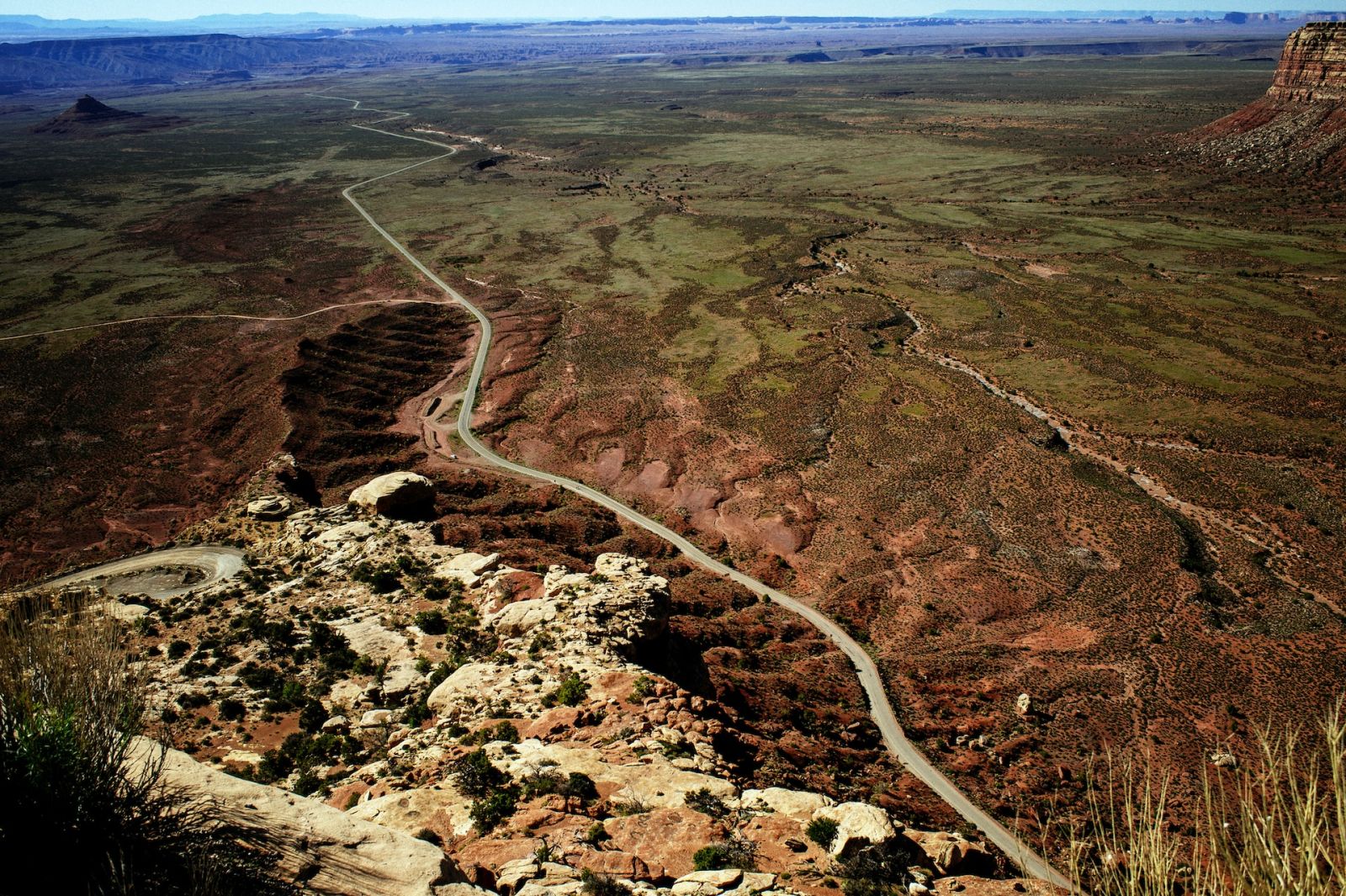
This unique stretch of road–which has literally been carved from steep cliff walls–connects Utah Highway 95 with US Highway 163. The dirt road forms part of the “Trail of the Ancients,” a national scenic byway where travelers can see multiple archeological sites and unique geological formations that played a role in the history of the southwest Native American people who inhabited this area.
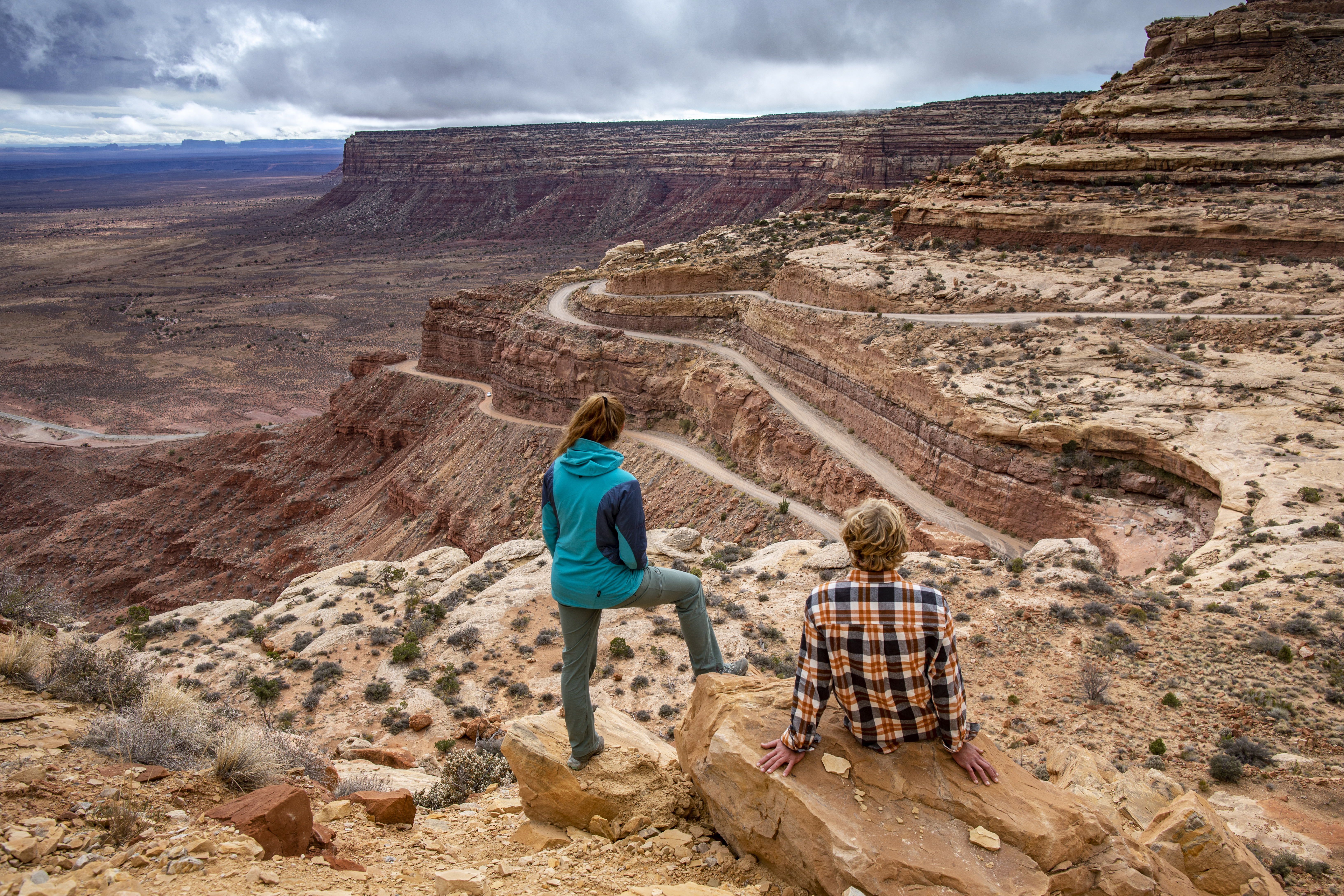
The Moki Dugway is famous for its steep, unpaved, but sharp switchbacks, which descend 1,200 feet from the top of Cedar Mesa. The relatively easy gravel road extends for about three miles and has a gradient of up to 10%.
The panoramic views from the top are breathtaking, giving travelers a bird's-eye view of the Valley of the Gods, Monument Valley, and the surrounding desert landscape. This is not merely a drive but an adventure – a test of nerve and a feast for the senses. For those seeking scenic drives that are out of the ordinary, the Moki Dugway is one of a kind!
Moki Dugway History
This stretch of road in Southeastern Utah is named for the Ancestral Pueblo that early Spanish explorers encountered in this area. The Spanish word “Moki" or "Moqui" and "Dugway", a term that refers to a roadway carved into a hillside or mountain.
The winding road has its roots firmly embedded in the mid-20th century's nuclear age. The Moki Dugway was constructed in the 1950s by the Texas Zinc mining company, and it was initially used to transport uranium ore from the Fry Canyon mines to a processing mill near Mexican Hat.
Today, it serves as one of the most enthralling routes for adventurous travelers, drawing thousands each year who come for the adrenaline rush and the spectacular views.
Driving Moki Dugway Scenic Backway
The Moki Dugway isn't just a road. It's a gateway to a range of attractions that offer a window into Utah's fascinating past and its stunning natural beauty.
The parking area near the top of Moki Dugway provides stunning views of some of the most iconic landscapes in all of the west including breathtaking panoramas of the Valley of the Gods, the Sleeping Ute Mountain in Colorado, & Shiprock in New Mexico.
Muley Point
Once climbing to the top of the Moki Dugway, you'll also find the turnout to head west to Muley Point Overlook. The Muley Point Overlook is located at the top of Cedar Mesa, about 4 miles off Highway 261.
Muley Point is an ideal spot for a picnic or simply to marvel at nature's grandeur. Offering breathtaking panoramas of the San Juan River Canyon below, where the stripes of different colored rocks create what is known as the “Navajo Tapestry.” The towers of Monument Valley are just visible in the distance making this a great stop for a quick tailgate picnic.
Weather conditions can change rapidly in this high desert region, so road closures are common. Check the weather forecast before setting off on your road trip.
Despite its intimidating reputation, the Moki Dugway is well-maintained and safe to all, and passable for passenger vehicles.
The road is wide enough to accommodate vehicles' passage easily, but there are no guardrails.
While driving, it’s important to remember to stay in low gear due to the grades and take turns slowly for safety. Cell service in the area can be spotty, so it is highly recommended to bring a map for navigation. Also, keep in mind that there are no services or amenities along the road, so ensure you have plenty of fuel, water, and supplies.
Ultimately, driving along the Moki Dugway is about appreciating the journey rather than rushing to the destination. So, take your time, drive safely, and soak in the unparalleled beauty of this remarkable route.
Nearby Attractions
➡️Goosenecks State Park (11 miles)
Goosenecks State Park offers a dramatic showcase of geology and the erosive power of water. From the park’s main viewing area, one can look down at a 1,000-foot-deep meander of the San Juan River, an ancient geological formation that resembles the twisting neck of a goose, hence its name.
➡️Mexican Hat (12 miles)
Named after a sombrero-shaped, 60-foot wide by 12-foot thick rock outcrop, the small town of Mexican Hat serves as a gateway to numerous adventures in Southeastern Utah. It's a perfect basecamp for travelers exploring Monument Valley, the Moki Dugway, and the San Juan River.
➡️Valley of the Gods (18 miles)
Valley of the Gods is a lesser-known but equally awe-inspiring cousin to Monument Valley. It offers a secluded landscape of towering sandstone monoliths and vast, open skies. The valley, free of crowds, offers a serene and intimate experience of the desert’s stark beauty.
➡️Monument Valley (46.8 miles)
Monument Valley is a region of the Colorado Plateau characterized by a cluster of vast sandstone buttes, the largest reaching 1,000 feet above the valley floor. Immortalized in countless Western films, its dramatic landscapes and iconic red hue offer an unmistakable testament to the enduring beauty of the American West.
FAQs
Is Moki Dugway safe to drive?
Yes, if you drive carefully! The roads are maintained and well-constructed. Because of the steep grade and elevation, drivers should obviously keep to a low speed and stay alert. But the Moki Dugway is no more dangerous to travel than most other high-mountain roads.
Is Highway 261 / Moki Dugway paved?
While Highway 261 is mostly paved, the specific stretch of road from top to bottom of the cliff known as “Moki Dugway” is not paved. The highway turns to gravel at the top and bottom of the dugway before becoming a regular blacktop again.