
Hydrological Scenarios and Malaria Incidence in the Amazonian Context
by
 , and
, and
Fernanda Fonseca
1,2,*, 
Bruna Worfarth-Couto
1,
Andre Santos
1,3,
Rogério Marinho
1,4,
Jean-Michel Martinez
5 and
Naziano Filizola
1,4,* 1
Programa de Pós-Graduação em Clima e Ambiente (CLIAMB, Instituto Nacional de Pesquisas da Amazônia/Universidade do Estado do Amazonas), Manaus 69060001, Brazil
2
Instituto Leônidas e Maria Deane, Fiocruz, Manaus 69057070, Brazil
3
Serviço Geológico do Brasil, Manaus 69060001, Brazil
4
Departamento de Geosciences, Universidade Federal do Amazonas, Manaus 69080900, Brazil
5
Institut de Recherche Pour L’environnement, 31400 Toulouse, France
*
Authors to whom correspondence should be addressed.
Water 2022, 14(8), 1283; https://doi.org/10.3390/w14081283
Submission received: 18 February 2022
/
Revised: 2 April 2022
/
Accepted: 8 April 2022
/
Published: 15 April 2022
(This article belongs to the Special Issue Tropical Rivers and Wetlands in the Anthropocene)
Abstract
:In Brazil, approximately 99% of malaria cases are concentrated in the Amazon region. An acute febrile infectious disease, malaria is closely related to climatic and hydrological factors. Environmental variables such as rainfall, flow, level, and color of rivers, the latter associated with the suspended sediment concentration, are important factors that can affect the dynamics of the incidence of some infectious diseases, including malaria. This study explores the possibility that malaria incidence is influenced by precipitation, fluctuations in river levels, and suspended sediment concentration. The four studied municipalities are located in two Brazilian states (Amazonas and Pará) on the banks of rivers with different hydrological characteristics. The results suggest that precipitation and river level fluctuations modulate the seasonal pattern of the disease and evidence the existence of delayed effects of river floods on malaria incidence. The seasonality of the disease has a different influence in each municipality studied. However, municipalities close to rivers with the same characteristic color of waters (as a function of the concentration of suspended sediments) have similar responses to the disease.
1. Introduction
In the current context of climate change, several authors have studied river variability as an important variable that regulates many aspects of human life in the Amazon basin and other basins around the world [1,2,3,4,5,6]. According to [7], rivers respond very quickly to the environmental conditions existing on the surface of continents. Thus, they are particularly sensitive to all changes, whether climatic or the result of human activities. Rivers play a key role in continental erosion, as they are responsible for transporting sediments (sands, clay particles, and silt), which move in suspension.
In the Amazon and probably many other watersheds on the planet, sediment transport has a very important relationship with factors such as depositional zone, bank caving, seasonal floodplains, and changes in the river channel [8]. For rivers in the Amazon basin, the main sources of sediment include materials from the Andes, the Brazilian shield, and the Guiana shield [9]. Associated with this are the effects of hydraulic dams [10,11], differences in the color of the water related to its chemical variability, and especially the transport of suspended sediments. The hydrology is also closely linked to the elements that form the regional climate, which are different in the north and south of the great basin, creating a complex and diverse river system. These elements result in a heterogeneous hydrological situation of fluvial behavior in the Amazon basin [11].
Although malaria is a well-recognized disease, it remains one of the main public health problems in the world. In 2019, the World Health Organization (WHO) recorded approximately 227 million cases of the disease and 558 thousand deaths [12].
Malaria is an acute febrile infectious disease caused by a parasite in the genus Plasmodium, which is transmitted to humans by the bite of an infected female mosquito of the genus Anopheles. In malaria dynamics, especially in the Amazon region, a variety of hydroclimatic factors may play a relevant role, including hydrological, climatic, environmental, and ecological conditions. Changes in hydrological patterns, influenced by rainfall variation and anthropogenic activities, can alter environmental conditions including the level and suspended sediment concentration in rivers. Such changes can significantly influence the density and longevity of the disease vector, by contributing to the formation of potential breeding sites, which can significantly impact the fluctuation and malaria incidence [3,5,13,14,15,16].
In Brazil, three species of parasites (Plasmodium vivax, Plasmodium falciparum, and Plasmodium malariae) are responsible for human infections of malaria. The main transmitter of the disease in the country are Anopheles darlingi mosquitoes, which are usually found in areas with high humidity and temperature [17,18,19]. More than 99% of malaria cases registered in Brazil are concentrated in the Amazon region [18].
Despite the recent WHO recommendation related to the publication of the [20], which is important in the fight against malaria in Africa, there is still no effective vaccine against the disease in the Amazon. Thus, disease control measures must be guided by actions that interrupt its evolutionary cycle to reduce contact between humans and the malaria vector. Recognizing areas with the presence of the vector and a greater understanding of the factors that contribute to the disease incidence can help define priority areas and decision making about vector control actions [18,21].
Considering the size of the Amazon basin, relatively few studies have focused on understanding the relationship between hydrological parameters and malaria incidence. Even fewer studies have analyzed the relationship between malaria incidence and the presence of sediments in water bodies, since these play an important role in the disease process. Sediment concentration alters the physical–chemical characteristics of the water, including temperature, turbidity, and pH, which could be related to ideal, but not always easily accessible, locations for the reproduction and to prolong the useful life of vectors [3].
As an alternative to mapping the water composition, recent studies demonstrated the efficient use of satellite data to identify the color of water, determine the concentration of suspended sediments, and map their dispersion [22,23,24,25,26].
To better understand the importance of hydrometeorological determinants in malaria transmission, this study explores the relationship between malaria incidence, precipitation pattern, and hydrological variability, analyzing the influence of river levels and suspended sediment concentration in four municipalities along the banks from different Amazonian rivers, located in two Brazilian states (Amazonas and Pará). These large rivers are excellent objects to study due to their lateral and longitudinal dimensions, as well as their relatively regular and seasonally well-marked hydrological characteristics. Furthermore, color differentiation of these water bodies allows differentiation of factors such as source and alteration of drained environments [9,27].
2. Materials and Methods
2.1. Study Area
The studied region is part of an extensive hydrographic network that constitutes the largest hydrographic basin in the world—the Amazon basin. According to [27], Amazonian rivers are classified into white, black, and clear waters. The ‘whitewater rivers’ usually originate in the Andes and carry large amounts of suspended sediment. The Amazon, Madeira, Purus, and Solimões rivers are important whitewater rivers. The ‘blackwater rivers’ have a dark color due to the high concentrations of fulvic and humid acids, carry a large amount of organic matter and little mineral material (sediment) from suspended sediments, and have an acidic pH. The greatest example of blackwater is the Negro River, which originates in the Guiana Shield. Finally, the ‘clearwater rivers’ (e.g., Tapajós and Trombetas), have a greenish color with a high degree of transparency and a less acidic pH than blackwater. These originate in the geologically ancient shields (Guianas and Central Brazil), carry a small amount of suspended sediments, and have a much lower concentration of dissolved organic matter than those of blackwater.
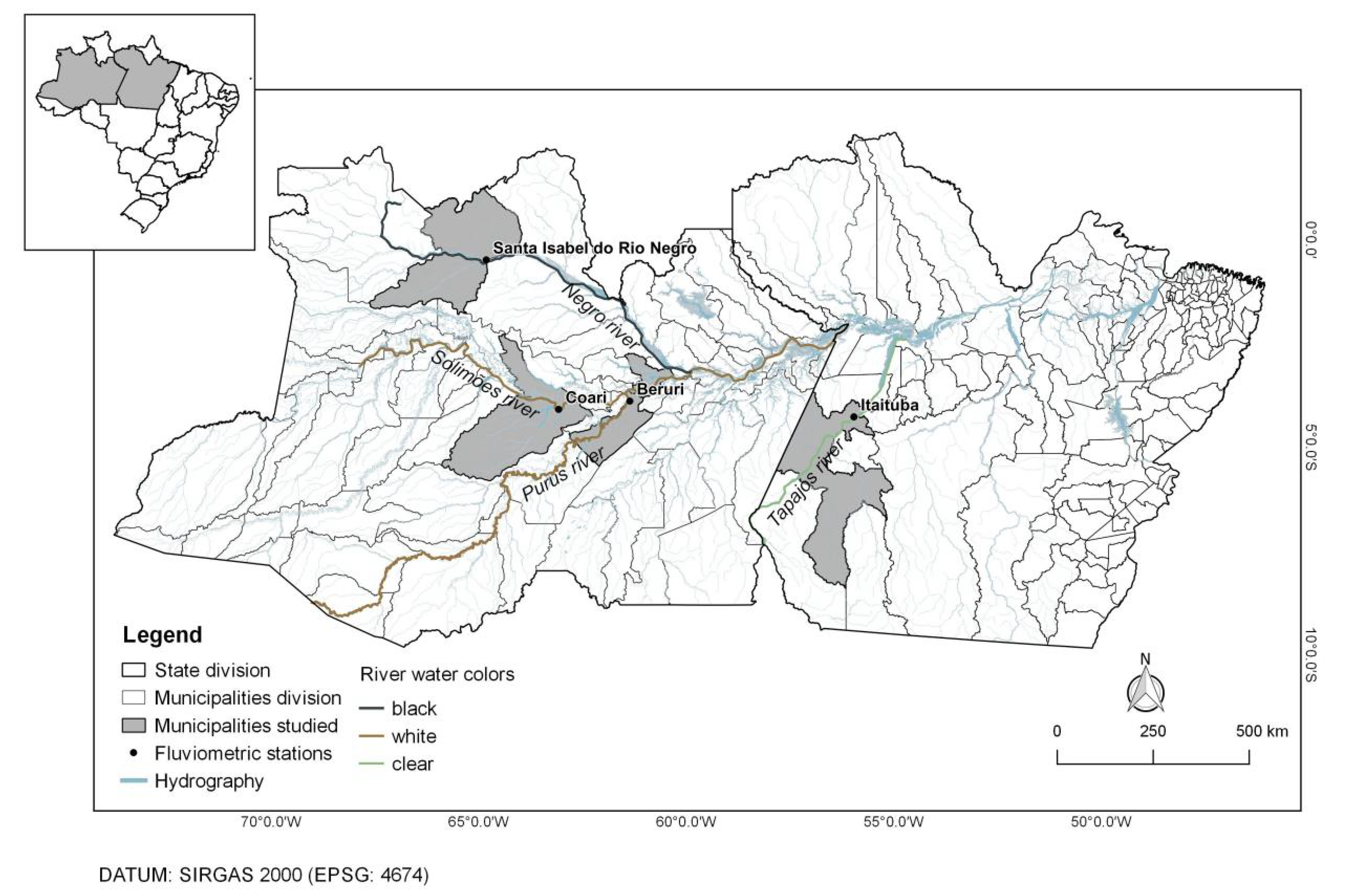
To better understand the dynamics of malaria in the Amazon, we selected four municipalities located on the banks of different Amazonian rivers, following the coloring criterion highlighted above. Located in two Brazilian states (Amazonas—AM and Pará—PA), the study municipalities were Beruri (AM), Coari (AM), Santa Isabel do Rio Negro (AM), and Itaituba (PA), which are situated, respectively, on the banks of the Purus River (whitewater), Solimões (whitewater), Negro River (blackwater), and Tapajós River (clearwater). Figure 1 illustrates the municipalities whose data were the object of this study, and Table 1 details the population characteristics of each investigated municipality, as well as their respective numbers of malaria cases in the investigated period (2005–2013).
2.2. Database and Methods
The study focuses on the relationship of malaria with climatic and hydrological variability, exploring whether this disease is influenced by precipitation, river oscillation, and Suspended Sediment Concentration (SSC) in rivers, for each municipality analyzed. Historical series from 2005 to 2015 were used from each station, chosen according to the availability of river water level, precipitation, and SSC data. The choice of data also considered years with months of uninterrupted data for all variables studied. Years with more than three consecutive months of data absence were excluded from the analysis.
Data on the population of the municipalities were obtained from the Brazilian Institute of Geography and Statistics (IBGE, Portuguese acronym). Monthly river level data, between 2005 and 2013, from the fluviometric stations of Beruri, Coari, Serrinha (in the municipality of Santa Isabel do Rio Negro), and Itaituba, were acquired from the Brazil National Water Agency (ANA, Portuguese acronym) and the database of the Environmental Research Observatory at the HYdro-geochemistry of the AMazonian Basin, currently the ORE/HYBAM Project (http://www.ore-hybam.org/, accesssed on 15 March 2019). The data on the SSC is from the reference network and ORE/HYBAM quality virtual stations. For the municipality of Itaituba, the data came directly from the reference network. For Beruri, Coari, and Santa Isabel do Rio Negro (Serrinha station), SSC data obtained from quality virtual stations were used, in which data derived from orbital remote sensors validated in the literature were employed to process this information, especially studies by [24] carried out on the Purus River, [25] on the Solimões River, and [28] on the Negro River. All the works used the visible-red (RED) and near-infrared (NIR) wavelength ranges of the MODIS sensor to estimate SSC.
For estimated precipitation, data were obtained from the Tropical Rainfall Measuring Mission (TRMM) through the product “TRMM 3B43V7”, developed by the National Aeronautics and Space Administration (NASA) in partnership with Japan Aerospace Exploration Agency (JAXA). This dataset combines microwave data from several satellites to produce a single monthly precipitation rate. The 3B43 product has been widely used for precipitation estimates, mainly because of its 3 h temporal resolution and 0.25° × 0.25° spatial resolution [29]. The monthly accumulated precipitation data were acquired from the cloud-based platform for geospatial analysis on a planetary scale Google Earth Engine, developed by Google and accessible at https://earthengine.google.com, accesssed on 10 July 2019.
Data on malaria case records were obtained from the Malaria Epidemiological Surveillance System (SIVEP-Malaria), available to authorized users at http://www.saude.gov.br/sivep_malaria, accesssed on 22 December 2020. SIVEP-Malaria is a Brazilian government program that archives all information about malaria cases registered in all health facilities and doctors’ offices. The data were preprocessed, as SIVEP-Malaria has some limitations in the use of its variables, such as the presence of “outliers” and the absence of data in certain places and periods, which, according to [30], affect spatial and temporal comparisons. Positive malaria data were filtered and counted by the probable municipality of infection, from which all malaria records in the municipality were considered, regardless of the type of parasite that caused the disease.
To be able to compare the frequency of the disease in different populations, the Monthly Parasitic Malaria Incidence (MPI) was calculated employing the following equation:
in which M is the number of positive tests for malaria in the month, per probable municipality of infection, and P is the total resident population of the municipality, in the year considered.
Daily data on malaria and precipitation were grouped into monthly accumulations, while river level and SSC data were averaged monthly in the years 2005 to 2013. For hydroclimatic data, missing monthly data (<1% of missing data) had to be filled in with the average based on data from the months before and after that month. Due to the existence of discrepancies (presence of “outliers” and absence of data) in the time series data, for seasonal comparison of the accumulated period, the median values were considered for data analysis.
To compare the variables, adjustments were necessary in the data to adapt them to the same scale. Thus, the hydroclimatic variables were normalized as a function of the difference between the observed data and their interannual mean, and in relation to the standard deviation. Exploratory data analysis, with time series graphs and association between normalized variables, made it possible to assess the data dispersion and seasonal behavior of hydroclimatic variables and malaria incidence rates. This enabled a comparative analysis between the different locations. Spearman correlation analyzes were performed between the MPI values and variables—SSC, river level, and precipitation, applying lags in relation to the MPI, with the objective of identifying delayed effects of these variables in the malaria incidence. We chose to use Spearman’s correlation rather than other existing correlation measures, as it is a non-parametric measure and does not require the assumption that the relationship between the variables is linear.
3. Results and Discussion
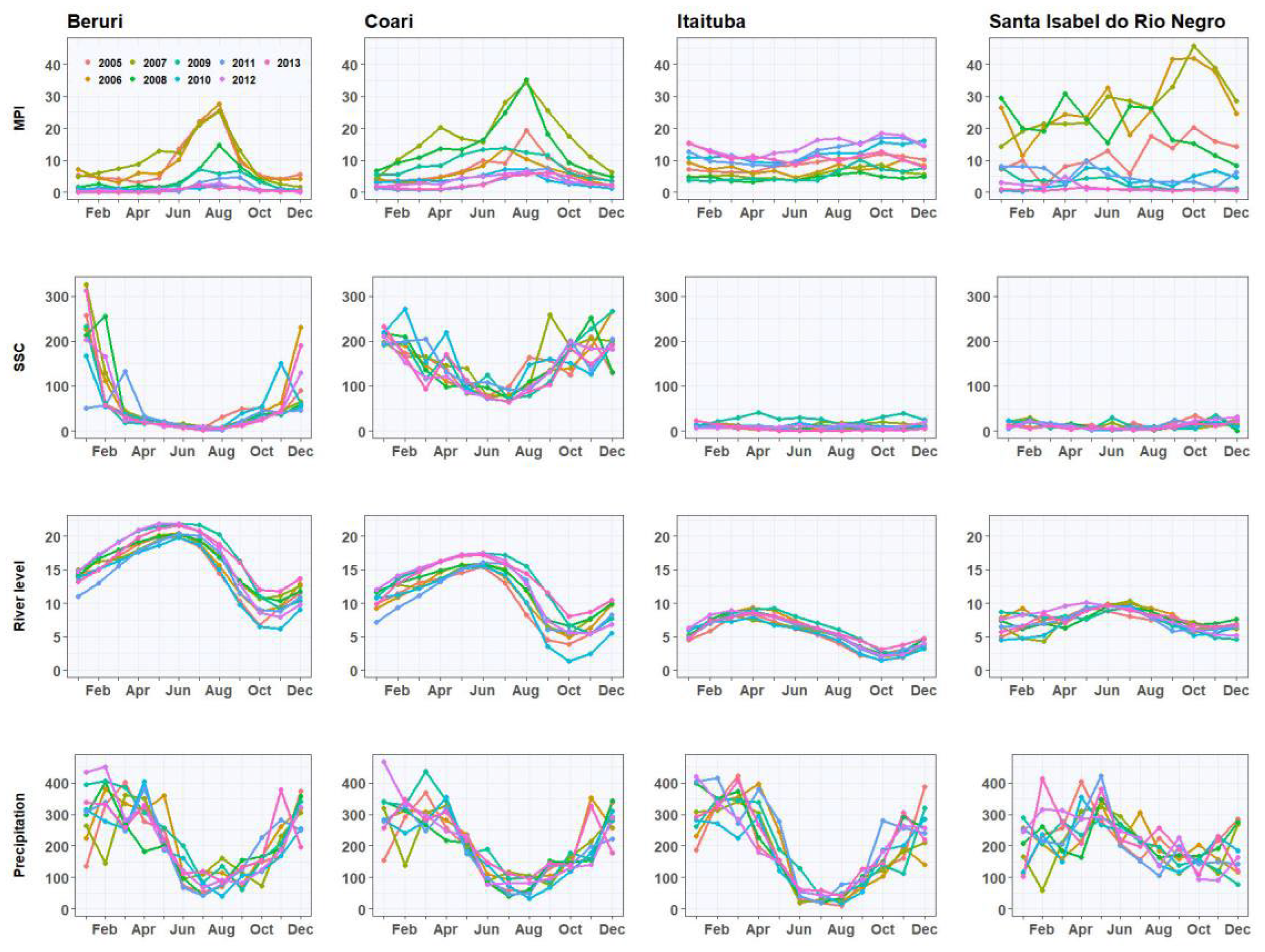
The results found for the distribution of time series for MPI, SSC, river level, and precipitation, in the municipalities of Beruri, Coari, Santa Isabel do Rio Negro, and Itaituba are presented in Figure 2 and Figure 3.
The malaria incidence and hydrological behavior displayed heterogeneous characteristics over the observed period in the four cities studied. However, well-marked seasonality patterns can be observed in the river level, precipitation, and SSC series. For the MPI, seasonality did not appear to be distinguishable due to a gradual reduction of that index over the years. This decrease in disease incidence is probably due to government interventions to control and combat malaria in recent decades, providing a substantial reduction in malaria notifications, hospitalizations, and deaths [12,31].
The precipitation regime in the four municipalities shows that the peak precipitation precedes the peak river level. According to Figure 2 and Figure 3, municipalities belonging to the same hydrographic basin have different hydrological regimes related to their location in the basin. The river level has a lag of months related to precipitation. This delay is connected to the geographic position of the municipality within the basin and to factors that control the Amazonian climate, such as the Intertropical Convergence Zone (ITCZ) and El Niño and La Niña phenomena [32].
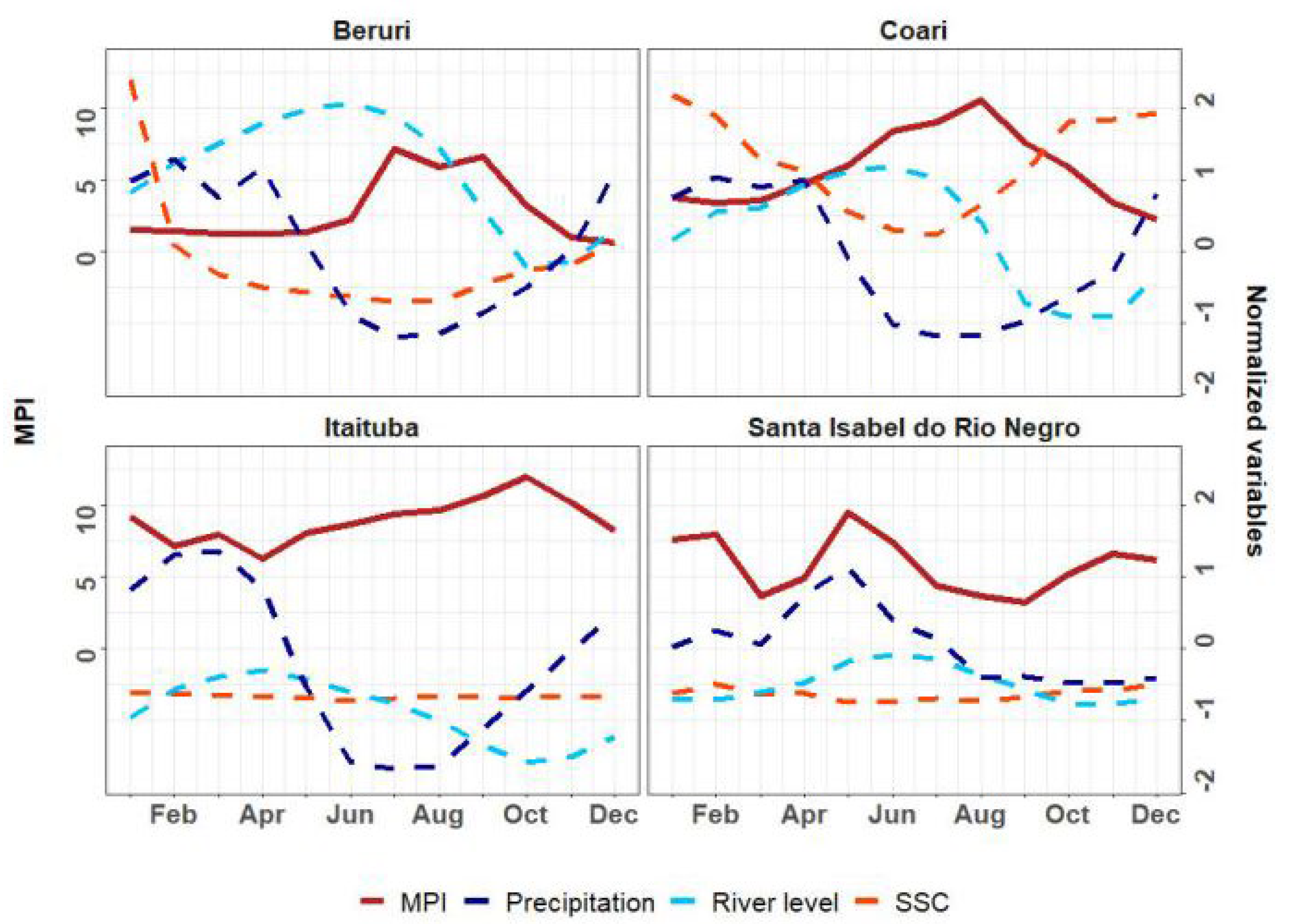
Common trends in hydrological dynamics are notable at Beruri and Coari stations, with a period of high water from April to August and peak in June. At these two stations, the seasonal amplitude of the SSC data varied dramatically and showed an inverse relationship with fluctuation in river level, in which low sediment concentration levels were observed throughout the high-water period. In Santa Isabel do Rio Negro and Itaituba, the seasonal distribution of precipitation continued to characterize the rise and fall of river levels, but with different hydrological scenarios (identified by seasonal variability in terms of rain and river levels), with flood peaks in June and April, respectively. These stations presented low sediment concentration throughout all years studied, with values below the interannual average and with little variability in the wet and dry periods, as observable in their median values (Figure 3).
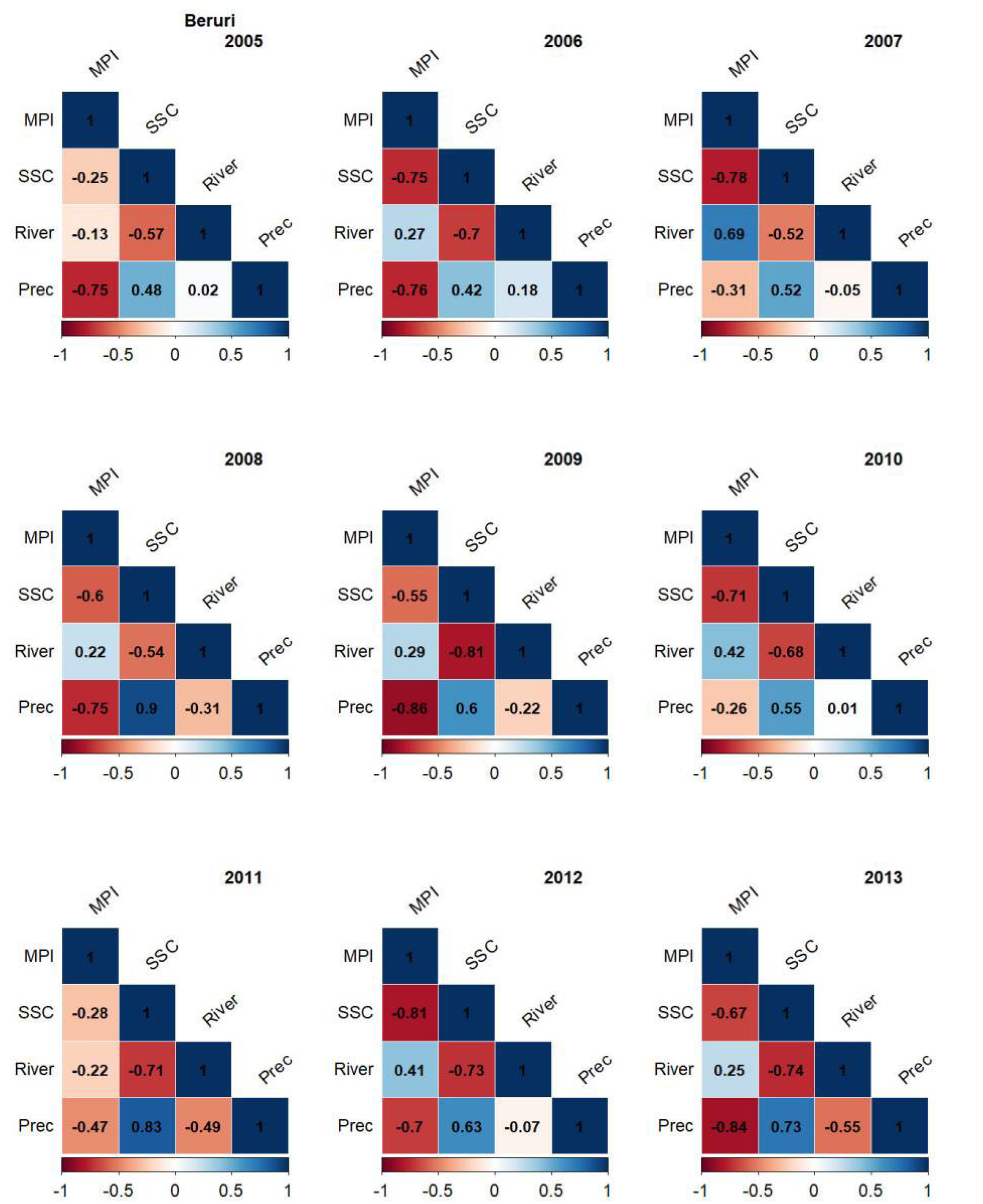
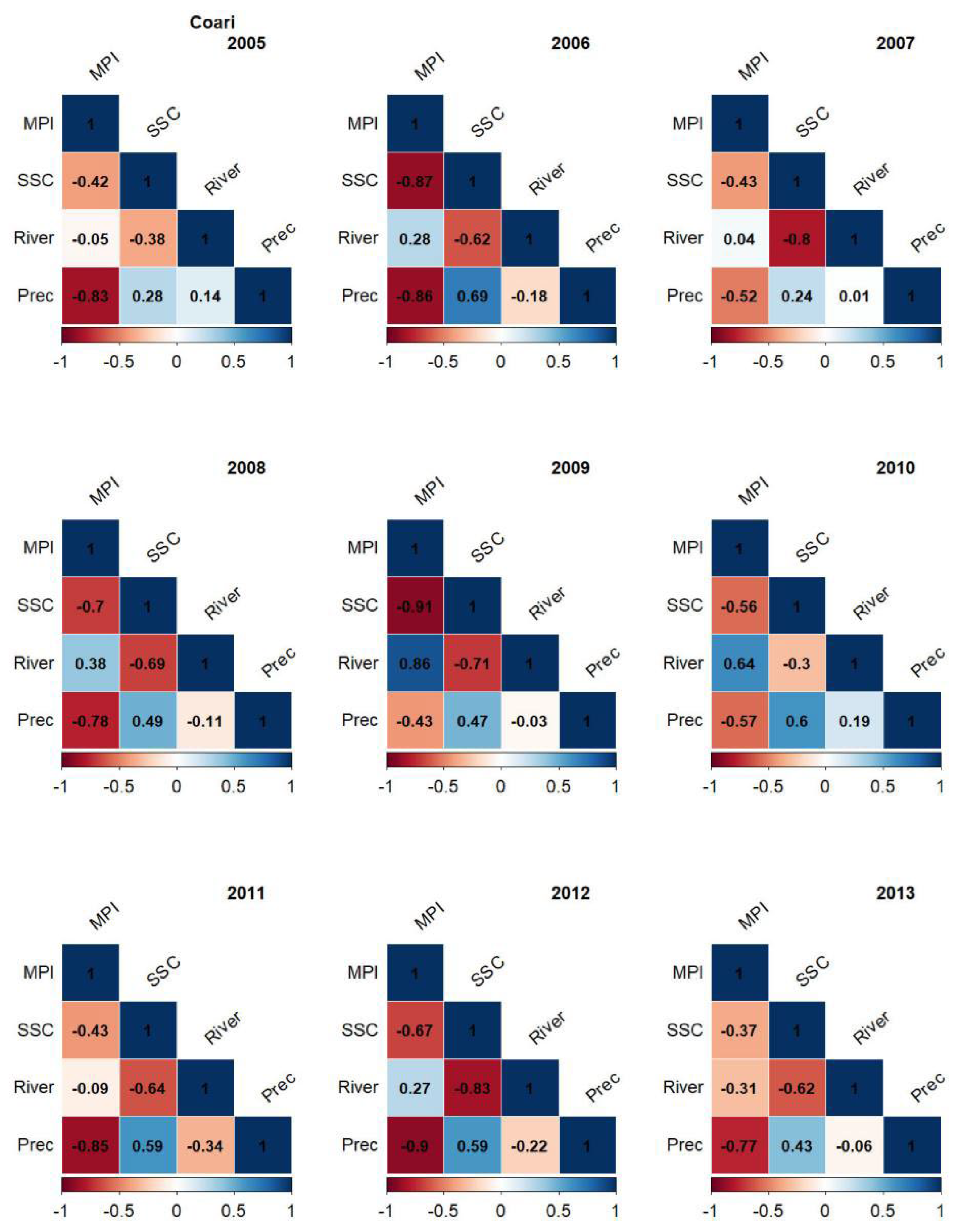
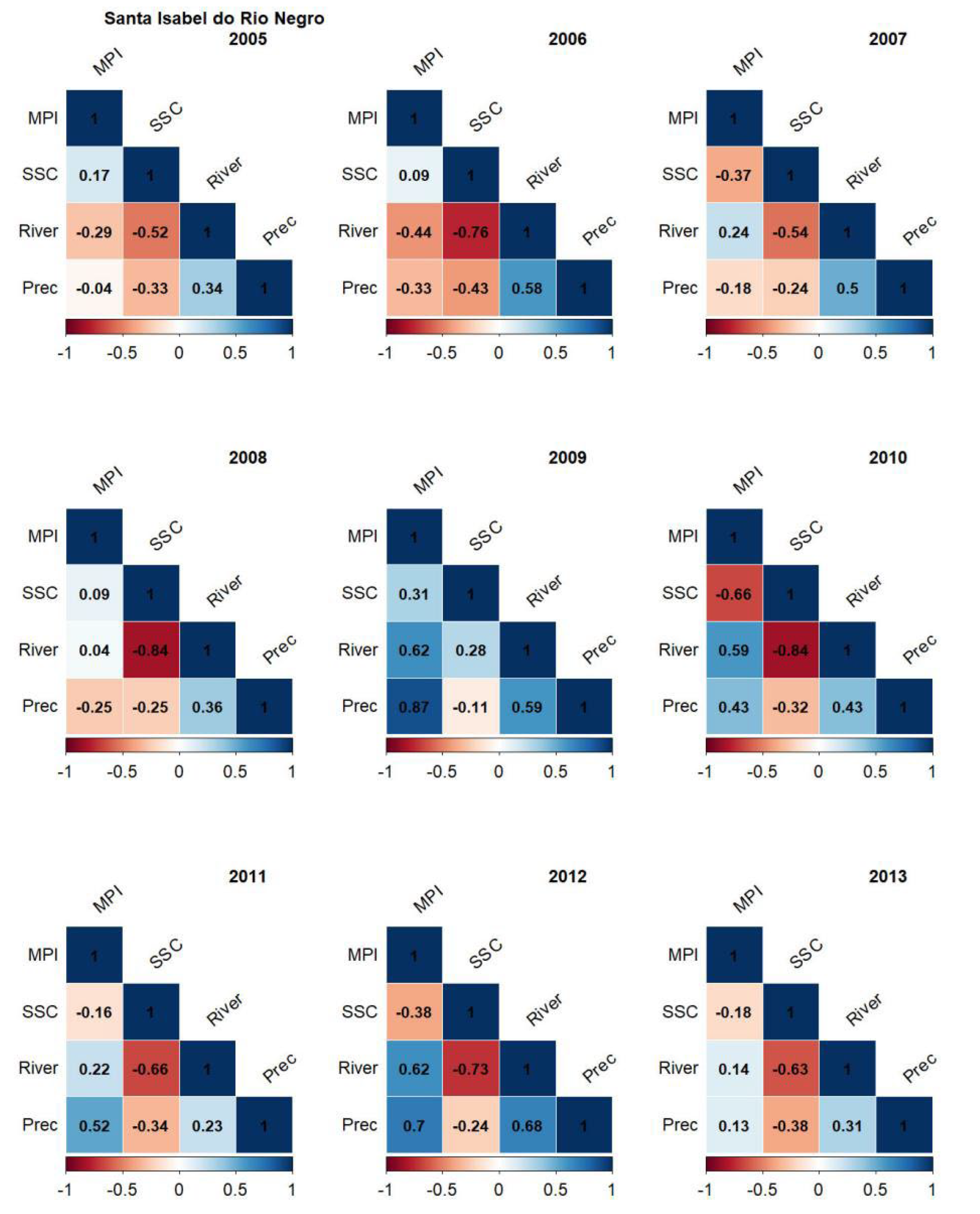
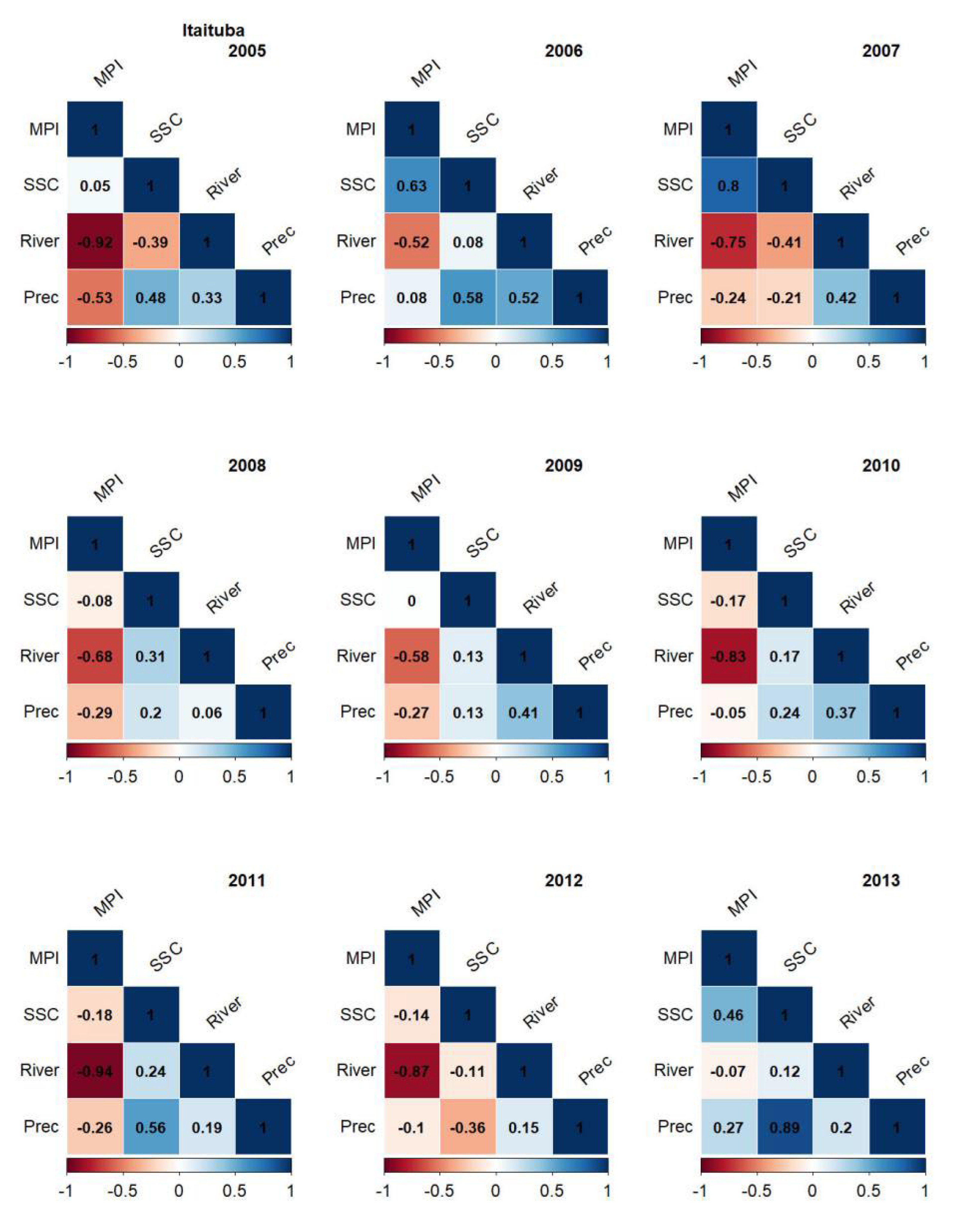
Figure 4, Figure 5, Figure 6 and Figure 7 present the association (via Spearman’s correlation) in the monthly data for each year between the MPI, SSC, river level, and precipitation for the study municipalities. Negative values, emphasized in red tones, indicate inverse association, while positive values in blue tones indicate direct relationships. The closer to 1 or −1, the stronger the relationship between the variables.
Beruri (Figure 4) followed a similar pattern to that observed in Coari (Figure 5), with a negative relationship between MPI, SSC, and Prec and direct association between MPI and River, in most years studied. In Beruri, the level of the rivers did not prove to be a relevant variable in modulating the disease incidence; however, when considering a lag in this relationship (Table 2), its relevance was strongly identified. Of all the years, 2009 stands out, during which a correlation between MPI and Prec of −0.86 was reached. This strong relationship may be associated with the extreme event (El Niño) that occurred that year, causing one of the largest river floods in the region.
Figure 5 illustrates that in Coari, there was a strong negative association between MPI and SSC, especially in 2006, 2008, and 2009. Precipitation also showed a relevant negative correlation with MPI. The correlation between MPI and River is especially evident in 2009 and 2010, exhibiting a positive relationship, in which the higher the level of the rivers, the higher the malaria incidence in this municipality. The results demonstrate, in most municipalities, an association between the variables Prec, River, and SSC. In Beruri and Coari, in most years of the study, a significant positive relationship was evident between Prec and SSC, as well as a significant negative relationship between River and SSC, reinforcing the influence of precipitation patterns and river oscillations on the dispersion of suspended sediments in the rivers.
In Santa Isabel do Rio Negro, the seasonal distribution of precipitation and river levels displayed a positive relationship with the disease in the years after 2007/2008 and a negative relationship in earlier years. This oscillation of signals is also reflected in the relationship between MPI and SSC, but with a low relationship over the years, and is most likely due to the little annual variation in SSC, which is characteristic of municipalities located on the banks of blackwater rivers, as in the case of Santa Isabel do Rio Negro. As in other municipalities, the relationship between MPI and Prec is especially evident in 2009, which had the highest recorded water in the region within the last 20 years, causing significant flooding.
The results presented in Figure 7 illustrate that Itaituba exhibited a strong relationship between MPI and River (negative correlation) over the years, especially in 2005, 2010, 2011, and 2012. This high negative association indicates that malaria tends to increase as the river levels reduce. As in Santa Isabel do Rio Negro, the correlation between MPI and SSC in Itaituba was direct in most years of study and not very evident, reaching a more expressive relationship only in 2006 and 2007. Itaituba is also a municipality located on the banks of rivers with low sediment concentration throughout the year and with little variability in the wet and dry periods, which may have been reflected in the low association between the MPI and SSC variables. However, in the MPI and SSC graphs (Figure 2 and Figure 3), higher rates of malaria incidence are evident throughout the year in places with low SSC throughout the period, such as in Itaituba and Santa Isabel of the Rio Negro.
The delayed effects of hydroclimatic variables on the malaria incidence were verified and with a delayed correlation of up to 3 months for the monthly data of SSC, river level, and precipitation in relation to MPI (Table 2). This delayed correlation reflected a significant increase in the MPI ratio and hydroclimatic variables, confirming their influence on the increase in malaria after periods of rain, flooding, and/or dispersion of suspended sediments.
In Coari, there was a considerable increase (with correlation of approximately 0.85–0.95) in the relationship between MPI and river level, with lags of 1 to 3 months, in almost all years of study, indicating that the disease tends to occur months after the rivers peak. A similar relationship was found by [4] in municipalities in the state of Amazonas, suggesting that the dynamics of the vector and transmission of malaria, despite delayed effects, follows the rise and fall of river levels. Precipitation was also presented a relevant increase, acting in the seasonal pattern of the disease. Still analyzing the Coari data, the years where the relationship between MPI and SSC was not very expressive, the delayed effects on the disease incidence strengthened after 1 or 2 months, especially in the years 2006, 2007, 2008, and 2012.
The correlation between SSC and MPI for certain years at the Beruri station was visible with delays of 1 or 2 months, reflecting in negative correlations above 69%, in the years 2005, 2008, 2009, and 2011. The effects of the elevation reflex of rivers in increasing disease were better perceived with lags of 2 or 3 months. In Beruri, the high negative correlation in almost all years between MPI and Prec did not increase with the data lag, with only the year 2011 exhibiting an increase from −0.47 to −0.77, when considering a 2-month lag of the disease after the rains.
In Santa Isabel do Rio Negro, the correlation between MPI and SSC showed an appreciable increase, with 1 to 3 months’ lag, in some years of the study, reinforcing the characterization of the disease distribution from the evaluated water composition. The fluctuation of the rivers, which in this municipality did not seem to be a determining variable in the disease modulation, in 2006 and 2007, when considering a lag of 3 months between River and MPI, reached a significant association with the disease. Precipitation in this municipality also did not exhibit a strong influence on the disease distribution for most years studied, except 2009 and 2012. In the latter year, when considering a lag of 1 month, the correlation reached 0.82.
In Itaituba (Figure 7), no direct action of precipitation in the distribution of malaria was identified; however, with lags of 2 and 3 months in the precipitation data reflected in the disease incidence, a strong correlation between these variables was visible, over almost all years investigated (Table 2). According to [33], peaks in malaria cases that antecede or precede precipitation peaks characterize disease peaks occurring at the beginning of the rainy season or during the dry season. This variation is linked to the existence of ecological niches that strengthen the vector cycle during these periods. The level of the rivers, which already showed to model the number of cases of the disease, when applying a time lag of 1 and 2 months in 2009 and 2010, respectively, exhibited significant increases in this relationship.
As in the municipality of Santa Isabel do Rio Negro, in Itaituba, the small variability and low SSC also did not indicate a strong relationship with the behavior of the disease, exhibiting both a positive and negative relationship over the years. Only 2007 had as a strong direct association in the distribution of the disease. However, the analysis of the seasonal pattern of MPI and SSC in the four municipalities studied (Figure 2 and Figure 3) found that the disease is more intense in places and periods of low SSC, on the banks of blackwater and clearwater rivers, such as in Santa Isabel do Rio Negro and Itaituba, respectively, which have a low concentration of suspended sediments in the rivers throughout the year and higher malaria incidence rates throughout the period. The positive correlation between MPI and SSC, which occurs especially in these municipalities, could indicate that although the disease occurs mainly in places with low SSC, the malaria incidence may be lower in places with absent or almost null SSC. This occurs in periods when the rivers are full, with a greater dispersion of suspended sediments, and in places that already have very low SSC throughout the year, reaching almost zero SSC in this period. Under these conditions, the disease is more pronounced when SSC is higher.
The Amazon rivers are part of heterogeneous ecosystems and provide different potential breeding grounds for the malaria vector. Studies have found that the ideal environment for Anopheles mosquitoes is generally on the banks of water bodies, with low flow, clean water, partially shade, superficial vegetation, and little input of salts and organic matter [34,35].
According to [36], the Rio Negro, which has acidic blackwater, is rich in dissolved fulvic and humic compounds and has low productivity and low electrical conductivity; thus, it provides a favorable environment for Anopheles darlingi. However, according to the results of the present work, rivers with very different characteristics to blackwater rivers, but with similar SSC parameters, such as clearwater rivers (Tapajós river), also presented a high rate of disease incidence throughout the year. This evidences that the presence of the malaria vector is not limited to the characteristics of blackwater rivers. Rather, it may be more related to the sedimentary levels in the rivers that can change the turbidity, pH, or temperature of the water, which could help to strengthen the evolutionary cycle of the disease. Some studies have observed negative associations between malaria vector abundance and water bodies with high turbidity, conductivity, and total dissolved solids [37,38]; while other studies even found a positive relationship [39], reinforcing the importance of understanding the hydrology and geomorphology of rivers for public health studies [3].
The results of this study are in line with research conducted in Brazil and around the world that related the influence of climate on the spread of malaria [3,5,6,13,14,15,16]. These authors evidenced that precipitation and the hydrological cycle are key factors that influence the abundance of Anopheles mosquitos. As in the results found in the different municipalities investigated, [15] also indicated that monthly precipitation can have positive and negative effects associated with the malaria incidence. Studies in the Peru [40] and Brazil [5,6] confirm and reinforce that the variation of river levels influences the dynamics of malaria, with peaks after river floods.
In summary, in view of the results presented, the oscillation of the rivers, which is directly related to local and regional precipitation, indicates a modulation in the seasonal pattern of malaria, with a lag (from 1 to 3 months) after the peak floods until the peak MPI, indicating possible delayed effects of the rivers floods on the disease incidence. The results indicated that the disease incidence generally tends to increase in periods of low SSC. In these periods, there is a strong possibility that environmental conditions favor the development of the disease vector. Malaria vectors have a very close relationship with temperature. Sediments in rivers can decrease water temperature in addition to increasing turbidity, conductivity and pH. We suggest that there is a minimum and maximum limit of SSC values that provide a favorable environment for the development of the disease cycle. However, the exact conditions still need to be elucidated, which is a knowledge gap that we are trying to fill. The results suggest that municipalities located on the banks of whitewater rivers with a large seasonal range of SSC, such as Beruri (Purus River) and Coari (Solimões River), can interrupt the development of malaria vectors, reducing the disease incidence in a period of high SSC. On the other hand, in locations located on the banks of rivers with low SSC throughout the year (rivers with black and/or clear waters), as is the case of Santa Isabel do Rio Negro (Rio Negro) and Itaituba (River Tapajós), a favorable environment trends to exist for the evolutionary cycle of malaria. Under these conditions, the malaria incidence does not have a seasonal variation with the flow regime of suspended sediments. In certain places, the contribution power of the river oscillation may not be as high, suggesting that other environmental or socioeconomic factors may be more associated with the disease incidence.
4. Conclusions
This study represents a first approach to study on the influence of hydroclimatic factors on the occurrence dynamics of malaria in municipalities in the Brazilian Amazon. A time series of those factors, from 2005 to 2013, was employed to analyze the relationship between the malaria incidence and the variation in the precipitation, river levels, and the concentration of suspended sediments in the rivers. The seasonal variability in precipitation and river levels seems to influence the seasonality of malaria. This is an important factor for local control during contagion periods, because the hydrological signal is the most important reference for the riverine Amazon, which is normally far from treatment centers. In addition, the disease is more intense in places and periods with low SSC, showing that this could be a favorable condition for the development of the malaria cycle, and could be another valuable signal to help riverside dwellers to adopt public health practices indicated by specific policies to combat the disease. Delayed effects of malaria incidence due to hydrometeorological variables were verified. The coronation of up to 3 months lag reflected a significant increase in the ratio of MPI and hydroclimatic variables, confirming their influence on the increased malaria, after periods of rain, flooding and/or dispersion of suspended sediments.
The results indicate that the differences between the stations studied are linked to factors such as the patterns of the studied variables. No single environmental factor but rather several somehow influence the occurrence of cases. The differences between seasons may also be related to local geomorphological issues (seasonally and permanently flooded areas, terrain slope, occurrence of terraces, etc.). Future work will expand the analysis to more municipalities in the Amazon region and study the relationship between SSC and the processes related to the way of life of the parasite and/or vectors. Furthermore, other associated climatic and environmental factors will be evaluated, such as temperature, humidity, vegetation and topography.
Author Contributions
Conceptualization, F.F., B.W.-C., J.-M.M. and N.F.; methodology, F.F. and N.F.; validation, F.F., A.S., R.M. and N.F.; formal analysis, F.F., J.-M.M. and N.F.; investigation, F.F., B.W.-C., A.S. and R.M.; writing—original draft preparation, F.F.; writing—review and editing, J.-M.M. and N.F.; visualization, F.F. and N.F.; supervision, N.F.; project administration, N.F.; funding acquisition, J.-M.M. and N.F. All authors have read and agreed to the published version of the manuscript.
Funding
This research was funded by the Fundação de Amparo a Pesquisa do Estado do Amazonas (FAPEAM), grant number 005/2019. N.F. received the support of the CAPES-PROCAD 2018 Amazonia Program (Projeto Rio Negro TAR) and CNPq—AmazonGeoSed Project, grant number 304636/2016-9.
Institutional Review Board Statement
The study was conducted in accordance with the Declaration of the Fundação de Vigilância em Saúde do Amazonas, and approved by the Ethics Committee of the Universidade Federal do Amazonas (protocol code 01.02.017306.000716/2020-15 and date of approval on 6 December 2020).
Informed Consent Statement
Not applicable.
Data Availability Statement
Malaria data in Sivep-Malaria (http://www.saude.gov.br/sivep_malaria, accesssed on 22 December 2020), river water level and SSC data in National Water Agency and ORE/HYBAM project (http://www.ore-hybam.org/, accesssed on 15 March 2019), precipitation: satellite data (product “TRMM 3B43V7”).
Acknowledgments
The authors would like to acknowledge Fundação de Vigilância em Saúde do Amazonas (FVS) for providing access to the malaria data and the Ethics Committee of the Universidade Federal do Amazonas for authorizing the use of the data. We received support from the Instituto Leônidas e Maria Deane (ILMD-Fiocruz Amazônia), the Universidade Federal do Amazonas (UFAM), the Institut de Recherche pour le Développement (IRD/France), the Graduate Program in Climate and Environment of the Instituto Nacional de Pesquisas da Amazônia, and the Universidade Estadual do Amazonas (PPGCLIAMB (INPA/UEA)), the Graduate Program in Geosciences of the Universidade Federal do Amazonas, the Graduate Program in Geoquímica of the Universidade Federal Fluminense, the Fundação de Amparo a Pesquisa do Estado do Amazonas (FAPEAM), the CNPq-AmazonGeoSed Project and CAPES-PROCAD 2018 Amazonia Program (Projeto Rio Negro TAR).
Conflicts of Interest
The authors declare no conflict of interest.
References
- Best, J. Anthropogenic stresses on the world’s big rivers. Nat. Geosci. 2019, 12, 7–21. [Google Scholar] [CrossRef]
- Latrubesse, E.; Arima, E.; Dunne, T.; Park, E.; Baker, V.; D’Horta, F.; Wight, C.; Wittmann, F.; Zuanon, J.; Baker, P.; et al. Damming the rivers of the Amazon basin. Nature 2017, 546, 363–369. [Google Scholar] [CrossRef] [PubMed]
- Smith, M.W.; Macklin, M.G.; Thomas, C.J. Hydrological and geomorphological controls of malaria transmission. Earth-Sci. Rev. 2013, 116, 109–127. [Google Scholar] [CrossRef]
- Wolfarth, B.; Filizola, N.; Tadei, W.; Durieux, L. Epidemiological analysis of malaria and its relationships with hydrological variables in four municipalities of the state of Amazonas, Brazil. Hydrol. Sci. J. 2013, 58, 1495–1504. [Google Scholar] [CrossRef]
- Wolfarth-Couto, B.; Silva, R.A.; Filizola, N. Variabilidade dos casos de malária e sua relação com a precipitação e nível d’água dos rios no estado do Amazonas, Brasil. Cad. De Saúde Pública 2019, 35, 2. [Google Scholar] [CrossRef] [Green Version]
- Wolfarth-Couto, B.; Filizola, N.; Durieux, L. Padrão sazonal dos casos de malária e a relação com a variabilidade hidrológica no estado do Amazonas, Brasil. Rev. Bras. De Epidemiol. 2020, 23, e200018. [Google Scholar] [CrossRef] [Green Version]
- Filizola, N.; Guyout, J.L.; Wittmann, H.; Martinez, J.M.; Oliveira, E. The Significance of Suspended Sediment Transport Determination on the amazonian hydrological scenario. In Sediment Transport in Aquatic Environments; Manning, A., Ed.; Intech: Rijeka, Croatia, 2011; pp. 45–64. [Google Scholar] [CrossRef] [Green Version]
- Hinderer, M. From gullies to mountain belts: A review of sediment budgets at various scales. Sediment. Geol. 2012, 280, 21–59. [Google Scholar] [CrossRef]
- Filizola, N.; Guyout, J.L. Suspended Sediment Yield in the Amazon Basin: An Assessment Using Brazilian National Data Set. Hydrol. Processes 2009, 23, 3207–3215. [Google Scholar] [CrossRef]
- Meade, R.H.; Rayol, J.M.; Conceição, S.; Natividade, J.R.G. Backwater effects in the Amazon River basin of Brazil. Environ. Geol. Water Sci. 1991, 18, 105–114. [Google Scholar] [CrossRef]
- Filizola, N.; Spínola, N.; Arruda, W.; Seyler, F.; Calmant, S. The Rio Negro and Rio Solimões confluence point -Hydrometric observations during the 2006/2007 cycle. In River, Coastal, Estuarine Morphodynamics: RCEM-2009; Vionnet, C., Garcia, M.H., Latrubesse, E.M., Perillo, G.M.E., Eds.; Taylor & Francis Group: London, UK, 2009; Volume 2, pp. 1003–1006. ISBN 978-0-415-55426-8. [Google Scholar]
- WHO. World Malaria Report 2021; World Health Organization: Geneva, Switzerland, 2021. [Google Scholar]
- Alemu, A.; Abebe, G.; Tsegaye, W.; Golassa, L. Climatic variables and malaria transmission dynamics in Jimma town, southwest Ethiopia. Parasites Vectors 2011, 4, 30. [Google Scholar] [CrossRef] [Green Version]
- Barros, F.S.M.; Honorio, N.A. Man biting rate seasonal variation of malaria vectors in Roraima, Brazil. Memórias Do Inst. Oswaldo Cruz 2007, 102, 299–302. [Google Scholar] [CrossRef] [PubMed] [Green Version]
- Olson, S.; Gangnon, R.; Elguero, E.; Durieux, L.; Guégan, J.; Foley, J.; Patz, J. Links between climate, malaria, and wetlands in the Amazon Basin. Emerg. Infect. Dis. 2009, 15, 659–662. [Google Scholar] [CrossRef] [PubMed]
- Stefani, A.; Hanf, M.; Nacher, M.; Girod, R.; CARME, B. Environmental, entomological, socioeconomic and behavioural risk factors for malaria attacks in amerindian children of Camopi, French Guiana. Malar. J. 2011, 10, 246. [Google Scholar] [CrossRef] [PubMed] [Green Version]
- Neves, D. Parasitologia Humana, 11th ed.; Atheneu: São Paulo, Brazil, 2005. [Google Scholar]
- BRASIL. Guia de Vigilância em Saúde, 1st ed.; Ministério da Saúde: Brasília, Brazil, 2017; Volume 3. [Google Scholar]
- BRASIL. Ministério da Saúde: Malária. Available online: http://portalms.saude.gov.br/saude-de-a-z/malaria (accessed on 15 February 2019).
- RTS S Clinical Trials Partnership. Efficacy and safety of RTS, S/AS01 malaria vaccine with or without a booster dose in infants and children in Africa: Final results of a phase 3, individually randomised, controlled trial. Lancet 2015, 386, 31–45. [Google Scholar] [CrossRef] [Green Version]
- BRASIL. Manual de Diagnóstico Laboratorial da Malária; Ministério da Saúde: Brasília, Brazil, 2005. [Google Scholar]
- Espinoza-Villar, R.; Martinez, J.; Texier, M.; Guyot, J.; Fraizy, P.; Menezes, P.R.; Oliveira, E. A study of sediment transport in the Madeira river, Brazil, using MODIS remote-sensing images. J. S. Am. Earth Sci. 2013, 44, 45–54. [Google Scholar] [CrossRef]
- Martinez, J.; Guyot, J.; Filizola, N.; Sondag, F. Increase in suspended sediment discharge of the Amazon river assessed by monitoring network and satellite. Catena 2009, 79, 257–264. [Google Scholar] [CrossRef] [Green Version]
- Santos, A.; Martinez, J.; Filizola, N.; Armijos, E.; Alves, L. Purus river suspended sediment variability and contributions to the Amazon river from satellite data (2000–2015). Comptes Rendus Geosci. 2018, 350, 13–19. [Google Scholar] [CrossRef]
- Espinoza-Villar, R.; Martinez, J.; Armijos, E.; Espinoza, J.; Filizola, N.; Santos, A.; Willems, B.; Fraizy, P.; Santini, W.; Vauchel, P. Spatio-temporal monitoring of suspended sediments in the Solimões river (2000–2014). Comptes Rendus Geosci. 2018, 350, 4–12. [Google Scholar] [CrossRef]
- Yepez, S.; Laraque, A.; Martinez, J.; Sa, J.; Carrera, J.; Castellanos, B.; Gallay, M.; Lopez, J. Retrieval of suspended sediment concentrations using landsat-8 OLI satellite images in the Orinoco river (Venezuela). Comptes Rendus Geosci. 2018, 350, 20–30. [Google Scholar] [CrossRef]
- Sioli, H. Sedimentation im Amazonasgebiet. Geol. Rundsch. 1957, 45, 608–633. [Google Scholar] [CrossRef]
- Marinho, R. Integração de dados de campo e sensoriamento remoto no estudo do fluxo de água e matéria no arquipélago de Anavilhanas, rio Negro-Amazonas, Brasil. Tese (Doutorado), Clima e Ambiente, Instituto Nacional de Pesquisas da Amazônia-INPA e Universidade do Estado do Amazonas-UEA, Manaus-AM. 2019. Available online: https://repositorio.inpa.gov.br/handle/1/12984 (accessed on 30 March 2020).
- NASA. National Aeronautics and Space Administration: TRMM Tropical Rainfall Measuring Mission. Available online: https://trmm.gsfc.nasa.gov/3b43.html (accessed on 30 March 2020).
- Wiefels, A.; Wolfarth-Couto, B.; Filizola, N.; Durieux, L.; MANGEAS, M. Accuracy of the malaria epidemiological surveillance system data in the state of Amazonas. Acta Amaz. 2016, 46, 383–390. [Google Scholar] [CrossRef] [Green Version]
- BRASIL. Programa Nacional de Prevenção e Controle da Malária PNCM.; Ministério da Saúde: Brasília, Brazil, 2003. [Google Scholar]
- Espinoza-Villar, J.C.; Ronchail, J.; Guyout, J.L.; Cochonneau, G.; Filizola, N.; Lavado, W.; Oliveira, E.; Pombosa, R.; Vauchel, P. Spatio-temporal rainfall variability in the Amazon basin countries (Brazil, Peru, Bolivia, Colombia, and Ecuador). Int. J. Climatol. 2009, 29, 1574–1594. [Google Scholar] [CrossRef] [Green Version]
- Gurgel, H. Paludisme et Dynamiques Environnementalles Dans l’état du Roraima au Brésil. Ph.D. Thesis, Université de Paris, Paris, Fance, 2006. [Google Scholar]
- Deane, L.; Causey, O.; Deane, M. Notas sobre a distribuição e biologia dos anofelinos das regiões Nordestina e Amazônica do Brasil. Rev. Do Serviço Espec. 1948, 1, 827–965. [Google Scholar]
- Tadei, W.; Thatcher, B.; Santos, J.S.; Rodrigues, I.; Rafael, M. Ecologic observations on anopheline vectors of malaria in the Brazilian Amazon. Am. J. Trop. Med. Hyg. 1998, 59, 325–335. [Google Scholar] [CrossRef] [PubMed]
- Tadei, W.; Rodrigues, I.; Rafael, M.; Sampaio, R.; Mesquita, H.; Pinheiro, V.C.S.; Zequi, J.; Roque, R.; Santos, J. Adaptative processes, control measures, genetic background, and resilience of malaria vectors and environmental changes in the Amazon region. Hydrobiologia 2017, 789, 179–196. [Google Scholar] [CrossRef]
- Edillo, F.E.; Toure, Y.T.; Lanzaro, G.C.; Dolo, G.; Taylor, C.E. Survivorship and distribution of immature Anopheles gambiae s.l. (Diptera: Culicidae) in Banambani Village, Mali. J. Med. Entomol. 2004, 41, 333–339. [Google Scholar] [CrossRef]
- Sattler, M.A.; Mtasiwa, D.; Kiama, M.; Premji, Z.; Tanner, M.; Killeen, G.F.; Lengeler, C. Habitat characterization and spatial distribution of Anopheles sp. mosquito larvae in Dar es Salaam (Tanzania) during an extended dry period. Malar. J. 2005, 4, 4. [Google Scholar] [CrossRef] [Green Version]
- Mala, A.O.; Irungu, L.W. Factors influencing differential larval habitat productivity of Anopheles gambiae complex mosquitoes in a western Kenyan village. J. Vector Borne Dis. 2011, 48, 52–57. [Google Scholar]
- Rama, C.; Vasquez, J.; Magallanes, J.; Carey, C. Variables climaticas y transmision de malaria en Loreto, Peru: 1995–2007. Rev. Peru. Med. Exp. Salud Publica 2009, 26, 9–14. [Google Scholar]
Figure 1.
Area studied in the Amazon region: municipalities in the Amazonas state (Beruri, Coari, Santa Isabel do Rio Negro) and Pará state (Itaituba), which are located, respectively, on the banks of the Purus River (whitewater), Solimões River (whitewater), Negro River (blackwater) and Tapajós River (clearwater).

Figure 2.
Time series (2005 to 2013) of monthly parasitic malaria incidence (MPI), suspended sediments concentration (SSC), river level, and precipitation for the studied municipalities: Beruri, Coari, Santa Isabel do Rio Negro, and Itaituba.
Figure 2.
Time series (2005 to 2013) of monthly parasitic malaria incidence (MPI), suspended sediments concentration (SSC), river level, and precipitation for the studied municipalities: Beruri, Coari, Santa Isabel do Rio Negro, and Itaituba.

Figure 3.
Median accumulated values for the years 2005 to 2013 of monthly parasitic malaria incidence (MPI) and normalized variables of suspended sediments concentration (SSC), river level, and precipitation for the study municipalities: Beruri, Coari, Itaituba, and Santa Isabel do Rio Negro.
Figure 3.
Median accumulated values for the years 2005 to 2013 of monthly parasitic malaria incidence (MPI) and normalized variables of suspended sediments concentration (SSC), river level, and precipitation for the study municipalities: Beruri, Coari, Itaituba, and Santa Isabel do Rio Negro.

Figure 4.
For the municipality of Beruri, the relationship between monthly malaria parasite index (MPI), of suspended sediment concentration in rivers (SSC), river level (River), and precipitation (Prec), during the period 2005–2013.
Figure 4.
For the municipality of Beruri, the relationship between monthly malaria parasite index (MPI), of suspended sediment concentration in rivers (SSC), river level (River), and precipitation (Prec), during the period 2005–2013.

Figure 5.
For the municipality of Coari, the relationship between monthly malaria parasite index (MPI), of suspended sediment concentration in rivers (SSC), river level (River), and precipitation (Prec), during the period 2005–2013.
Figure 5.
For the municipality of Coari, the relationship between monthly malaria parasite index (MPI), of suspended sediment concentration in rivers (SSC), river level (River), and precipitation (Prec), during the period 2005–2013.

Figure 6.
For the municipality of Santa Isabel do Rio Negro, the relationship between monthly malaria parasite index (MPI), of suspended sediment concentration in rivers (SSC), river level (River), and precipitation (Prec), during the period 2005–2013.
Figure 6.
For the municipality of Santa Isabel do Rio Negro, the relationship between monthly malaria parasite index (MPI), of suspended sediment concentration in rivers (SSC), river level (River), and precipitation (Prec), during the period 2005–2013.

Figure 7.
For the municipality of Itaituba, the relationship between monthly malaria parasite index (MPI), of suspended sediment concentration in rivers (SSC), river level (River), and precipitation (Prec), during the period 2005–2013.
Figure 7.
For the municipality of Itaituba, the relationship between monthly malaria parasite index (MPI), of suspended sediment concentration in rivers (SSC), river level (River), and precipitation (Prec), during the period 2005–2013.


Table 1.
River, water color, number of malaria cases (Cases) and population characteristics (Pop.) in the municipalities during the study period.
Table 1.
River, water color, number of malaria cases (Cases) and population characteristics (Pop.) in the municipalities during the study period.
| Coari | Beruri | Santa Isabel do Rio Negro | Itaituba | |
|---|---|---|---|---|
| River | Solimões | Purus | Negro | Tapajós |
| Water color | White | White | Black | Clear |
| Cases/Pop. (2005) | 7378/84,309 | 1397/13,220 | 1028/7617 | 10,098/96,246 |
| Cases/Pop. (2006) | 6356/87,468 | 1490/13,620 | 2321/7077 | 8523/96,515 |
| Cases/Pop. (2007) | 13,327/65,222 | 1666/13,809 | 5564/16,921 | 8062/118,194 |
| Cases/Pop. (2008) | 11,326/67,055 | 686/14,374 | 4304/17,780 | 6646/124,865 |
| Cases/Pop. (2009) | 6979/66,991 | 468/14,705 | 633/18,506 | 7862/127,848 |
| Cases/Pop. (2010) | 3554/75,965 | 185/15,486 | 810/18,146 | 13,607/97,493 |
| Cases/Pop. (2011) | 2618/76,646 | 240/15,827 | 1188/18,728 | 14,379/97,704 |
| Cases/Pop. (2012) | 3376/77,305 | 172/16,158 | 353/19,292 | 16,699/97,908 |
| Cases/Pop. (2013) | 2917/81,325 | 143/17,332 | 211/20,986 | 12,731/98,363 |
Table 2.
Correlation of lag in monthly data on suspended sediment concentration in rivers (SSC), river level (River), and precipitation (Prec) with the monthly malaria parasite index (MPI). The table presents the years that had a significant increase in the lag ratio variables (up to 3 months) with MPI: Year (correlation).
| Beruri | Coari | |||||
| 1 Month Lag | 2 Months Lag | 3 Months Lag | 1 Month Lag | 2 Months Lag | 3 Months Lag | |
| MPI × SSC | 2008 (−0.71) 2009 (−0.89) | 2005 (−0.69) 2011 (−0.73) | 2005 (−0.71) 2006 (−0.89) 2008 (−0.78) | 2007 (−0.84) 2011 (−0.77) 2012 (−0.86) | ||
| MPI × River | 2006 (0.81) 2007 (0.94) 2009 (0.82) 2010 (0.67) 2011 (0.72) 2012 (0.90) | 2005 (0.55) 2008 (0.89) | 2009 (0.97) | 2006 (0.85) 2007 (0.91) 2008 (0.96) 2010 (0.92) 2012 (0.92) | 2005 (0.92) 2011 (0.80) | |
| MPI × Prec | 2011 (−0.77) | 2011 (−0.94) | 2009 (0.63) | |||
| Santa Isabel do Rio Negro | Itaituba | |||||
| 1 Month Lag | 2 Month Lag | 3 Month Lag | 1 Month Lag | 2 Month Lag | 3 Month Lag | |
| MPI × SSC | 2005 (0.73) | 2007 (−0.66) | 2006 (−0.62) | 2005 (−0.80) | ||
| MPI × River | 2006 (0.78) 2007 (0.59) | 2010 (−0.92) | 2009 (−0.80) | |||
| MPI × Prec | 2012 (0.82) | 2005 (−0.89) 2006 (−0.66) 2007 (−0.87) 2008 (−0.80) | 2010 (−0.79) 2011 (−0.77) 2012 (−0.85) | |||
Publisher’s Note: MDPI stays neutral with regard to jurisdictional claims in published maps and institutional affiliations. |
© 2022 by the authors. Licensee MDPI, Basel, Switzerland. This article is an open access article distributed under the terms and conditions of the Creative Commons Attribution (CC BY) license (https://creativecommons.org/licenses/by/4.0/).
Share and Cite
MDPI and ACS Style
Fonseca, F.; Worfarth-Couto, B.; Santos, A.; Marinho, R.; Martinez, J.-M.; Filizola, N. Hydrological Scenarios and Malaria Incidence in the Amazonian Context. Water 2022, 14, 1283. https://doi.org/10.3390/w14081283
AMA Style
Fonseca F, Worfarth-Couto B, Santos A, Marinho R, Martinez J-M, Filizola N. Hydrological Scenarios and Malaria Incidence in the Amazonian Context. Water. 2022; 14(8):1283. https://doi.org/10.3390/w14081283
Chicago/Turabian StyleFonseca, Fernanda, Bruna Worfarth-Couto, Andre Santos, Rogério Marinho, Jean-Michel Martinez, and Naziano Filizola. 2022. "Hydrological Scenarios and Malaria Incidence in the Amazonian Context" Water 14, no. 8: 1283. https://doi.org/10.3390/w14081283
Note that from the first issue of 2016, this journal uses article numbers instead of page numbers. See further details here.