Article

Increased Water Abstraction and Climate Change Have Substantial Effect on Morphometry, Salinity, and Biotic Communities in Lakes: Examples from the Semi-Arid Burdur Basin (Turkey)

by
Mehmet Arda Çolak
1,*,
Barış Öztaş
2,
İbrahim Kaan Özgencil
3,4,
Melisa Soyluer
3,4,
Mustafa Korkmaz
3,5,
Arely Ramírez-García
3,6,
Melisa Metin
3,
Gültekin Yılmaz
5,
Serhat Ertuğrul
5,
Ülkü Nihan Tavşanoğlu
7,
Cihelio Alves Amorim
3,
Can Özen
8,
Meral Apaydın Yağcı
9,
Abdulkadir Yağcı
9,
Juan Pablo Pacheco
10,
Korhan Özkan
5,8,
Meryem Beklioğlu
3,8,
Erik Jeppesen
3,5,8,11,12 and
Zuhal Akyürek
1,2,8
1
Department of Geodetic and Geographic Information Technologies, Middle East Technical University, 06800 Ankara, Turkey
2
Department of Civil Engineering, Middle East Technical University, 06800 Ankara, Turkey
3
Department of Biological Sciences, Middle East Technical University, 06800 Ankara, Turkey
4
Simurg Bird Sanctuary, 06800 Ankara, Turkey
5
Institute of Marine Sciences, Middle East Technical University, 33731 Mersin, Turkey
6
Programa Institucional de Doctorado en Ciencias Biológicas, Universidad Michoacana de San Nicolás de Hidalgo, Morelia 58000, Mexico
7
Department of Biology, Çankırı Karatekin University, 18100 Çankırı, Turkey
8
Centre for Ecosystem Research and Implementation (EKOSAM), Middle East Technical University, 06800 Ankara, Turkey
9
Department of Fisheries, Sheep Breeding Research Institute, Republic of Turkey Ministry of Agriculture and Forestry, 10200 Balıkesir, Turkey
10
Centro Universitario de la Regional del Este (CURE), Universidad de la República, Maldonado 11200, Uruguay
11
Department of Ecoscience and Arctic Research Centre (ARC), Aarhus University, 8600 Silkeborg, Denmark
12
Sino-Danish Centre for Education and Research (SDC), Beijing 101408, China
*
Author to whom correspondence should be addressed.
Water 2022, 14(8), 1241; https://doi.org/10.3390/w14081241
Submission received: 24 February 2022 / Revised: 2 April 2022 / Accepted: 6 April 2022 / Published: 12 April 2022
(This article belongs to the Special Issue Global Change Effects on Water Level and Salinity: Causes and Effects)

Abstract

:
Global warming and altered precipitation patterns are predicted to intensify the water loss in semi-arid and arid regions, and such regions in Turkey will be particularly affected. Moreover, water abstraction, not least for irrigation purposes, is expected to increase markedly, posing major threats to the water balance of the lakes and thus their biodiversity. Among the closed basins in Turkey, the Burdur Closed Basin (BCB), located in the southwest of Turkey, is expected to be most affected. The BCB includes several types of aquatic ecosystems which support high biodiversity, including one Ramsar site, six Important Bird Areas, and a considerable richness of native and endemic fish species. Therefore, it is essential to analyze the potential environmental impacts of climate change and increased water abstraction on BCB lakes and their biotic communities. Here, we combined historical data on ecosystems as well as meteorological, remote sensing, and ground-truth data to analyze the changes in the temperature and precipitation of the BCB, water surface areas, and land use, as well as the potential effects on waterbird and fish communities. We calculated the water budget to elucidate water availability in the basin over the last few decades and predicted future conditions based on rainfall and temperature forecasts using climate models. The Standardized Precipitation–Evapotranspiration Index (SPEI) was used to relate the water surface area to precipitation and temperature change in the basin. Crop-farming irrigation in the BCB has increased notably since 2004, leading to intensive water abstraction from the lakes and their inflows, as well as from ground water, to meet the increased demand for irrigation. The water abstraction from the lakes, inflows to the lakes, and the groundwater in the basin has increased the water loss in the catchment substantially. Remotely sensed data on lake surface areas showed a major shrinkage of shallow lakes in the last 40 years. Moreover, the largest lake in the basin, Lake Burdur, lost nearly half of its surface area, which is worrisome since the shallower areas are the most suitable for supporting high biodiversity. Climate models (CNRM-ESM2-1GCM for temperature and GFDL-ESM4-GCM for precipitation) suggest that from 2070, the BCB will face long-term, moderate-to-severe dry periods. This, and the increased demand for water for irrigation, along with climate change, may accelerate the drying of these lakes in the near future with devastating effects on the lake ecosystems and their biodiversity.

1. Introduction

Global warming and altered precipitation patterns are predicted to intensify water loss in semi-arid and arid regions [1,2]. Among the eastern Mediterranean countries, Turkey will likely experience major increases in summer drought [3]. A recent study, based on global circulation models (GCMs) [4], showed that there will be at least a 2 °C increase in spring and summer mean temperatures and a 10% decrease in annual total precipitation in Turkey by 2100. Moreover, water abstraction, not least for irrigation purposes, is expected to increase markedly [5,6]. These changes are major threats to the water balance of many lakes that may dry out temporarily or permanently, with the shallower areas being particularly vulnerable. This may increase the salinity of the remaining lakes, leading to a loss of biodiversity, and subsequently leading to changes in ecosystem functions and services [7,8,9,10,11].
A recent paper on the semi-arid Konya Closed Basin (KCB), Turkey, analyzed the changes in water balance and crop patterns and showed that water-thirsty crops and their demand for water have intensified over the past few decades [12] This, combined with climate warming, has led to a substantial reduction of the groundwater level (>1 m/year) and a major decline in the surface area of lakes and wetlands, followed by an increase in salinization and a pronounced decrease of waterbird and fish populations, of which many are endemic [12]. A recent study, describing the predicted changes in the hydrogeological reserve of the basins in Turkey, reveals that the Burdur Closed Basin (BCB) will be the most affected Anatolian basin [13]. Although the BCB is the smallest of the closed basins in Turkey, it is estimated that, at the end of the present century, due to the effects of climate change, the hydrogeological reserve of the basin will decrease by 14% and the possible reserve by 26% [13] compared with 3% and 6% in the KCB, which has already faced dramatic changes in recent decades [12]. In the BCB, there are extensive agricultural activities (as in the KCB) that depend heavily on surface water and groundwater abstraction, and the surface water has been controlled by constructing dams that provide water for irrigation. The BCB includes the second- and third-deepest lakes in Turkey, while the lakes in the KCB are mainly shallow. In both areas, the lakes host large and diverse waterbird and fish populations. Some of the shallow lakes in both basins have already dried out, and the deeper lakes in the BCB have shown signs of shrinkage due to increased evaporation and water abstraction [14]. Therefore, it is essential to analyze the potential environmental impacts of climate change and increased water abstraction on BCB lakes and their biotic communities.
In this study, we aim at elucidating the effect of increased water abstraction and climate change on the morphometry, salinity, and biotic communities in the BCB, which faces a severe water shortage. We combined remote sensing data, meteorological data, and water budget calculations to analyze the changes in the amount of water in the lakes in the basin and the consequent effects on waterbird and fish populations. Furthermore, climate models (CMIP6) were used to predict the potential changes in temperature and precipitation in the basin until the end of the century. The novelty of this study is that we relate the lake surface area as derived from satellite images to the SPEI, which is an index commonly used as an indicator of hydrological and meteorological droughts. With the help of climate model results, where the CMIP6 results are used for the first time for this basin, possible drought and wet periods can be predicted for the largest lake in the basin, and the effects on birds and fish are discussed. We took a close look at the basin in three case studies; we investigated the hydrological past and future of Lake Burdur in one of them; in the second one, we presented the bird and fish community changes in Lake Acıgöl, which is facing different pressures. Finally, we analyzed the current situation of the breeding avifauna, changes in the wintering waterbird populations, and the rapid decline of the most enigmatic bird in the basin, the White-headed Duck (Oxyura leucocephala), based on a review of bibliographic data.

2. Materials and Methods
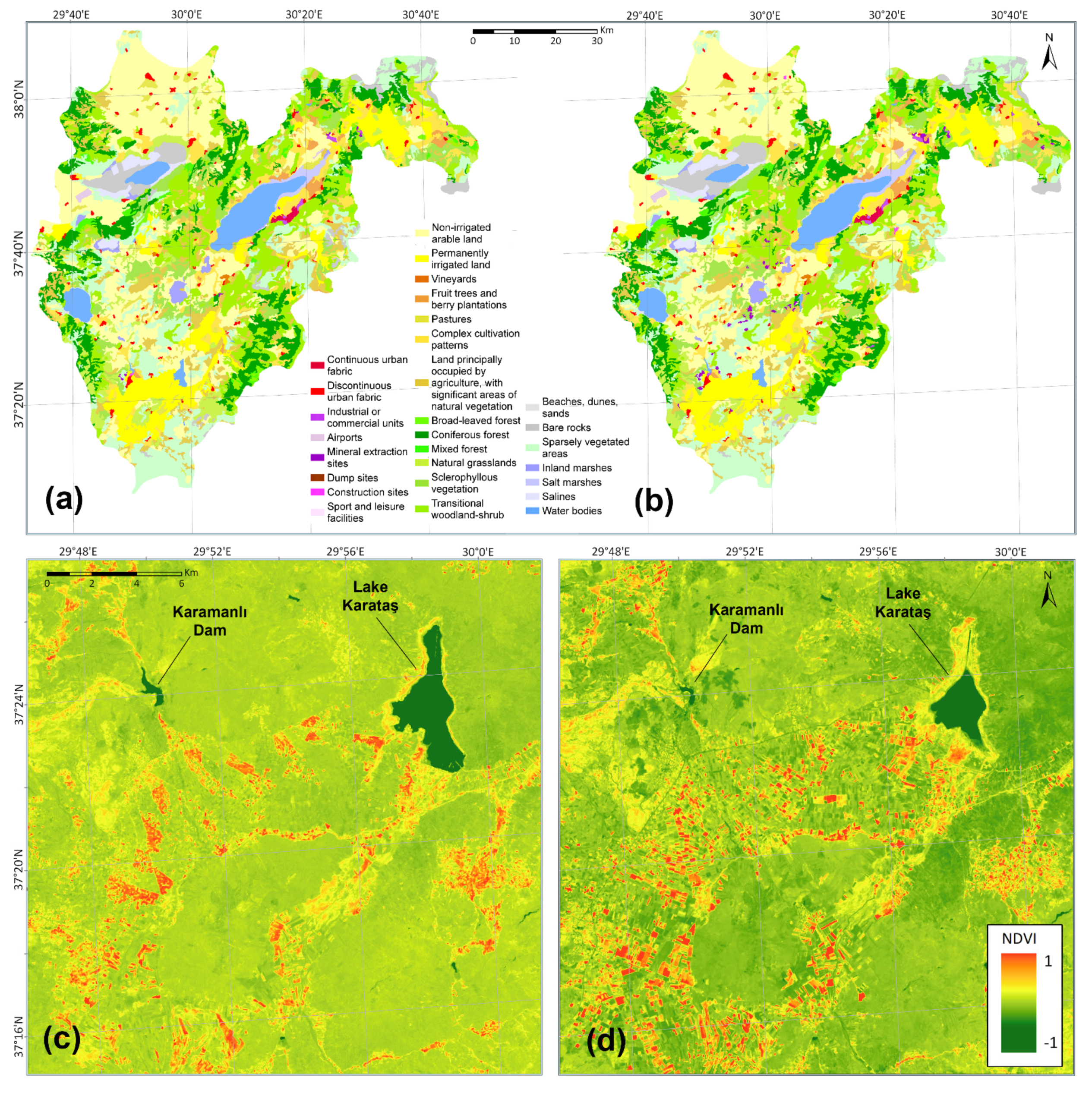
2.1. Study Area

The mountainous Burdur Closed Basin (BCB, area 6296 km2) is located in the southwest of Turkey, has a mean elevation of 1200 m, and contains deep lakes as a result of the Taurus graben formation in the Miocene and Pliocene periods [15]. The basin includes six large natural lakes: Lakes Acıgöl, Akgöl, Burdur, Salda, Yarışlı, and Karataş (Figure 1). Lake Akgöl has already dried out. Lakes Salda (max. depth: 184 m) and Burdur (max. depth: 110 m) are the second- and third-deepest lakes in Turkey, respectively. Moreover, there are six sub-basins, including the Burdur sub-basin, which is the largest. While the surface water flows into the lakes from the sub-basins Acıgöl, Akgöl, Salda, Yarışlı, and Burdur, in sub-basin Atabey, located in the north-eastern part of the BCB, surface water contributes only to the groundwater because of its karstic geology (Figure 1) [16].
Variation in climate in the Holocene altered the landscape and the water balance of the lakes. Sediment cores from Lake Burdur revealed that the lake level fluctuated between 10 and 13 m during the Holocene [17,18]. The lowest water level in the last millennia occurred around 300 BC (the same as today’s level), while its highest level was in the humid Medieval Warm Period [18]. Consistently, a multiproxy study of Lake Salda sediment showed that, in the last two millennia before the modern period, the climate variability of the region was mainly influenced by solar forcing [19]. However, with the agricultural intensification in the modern era, human activity overruled the climatic variation in terms of lake levels and salinity [20].

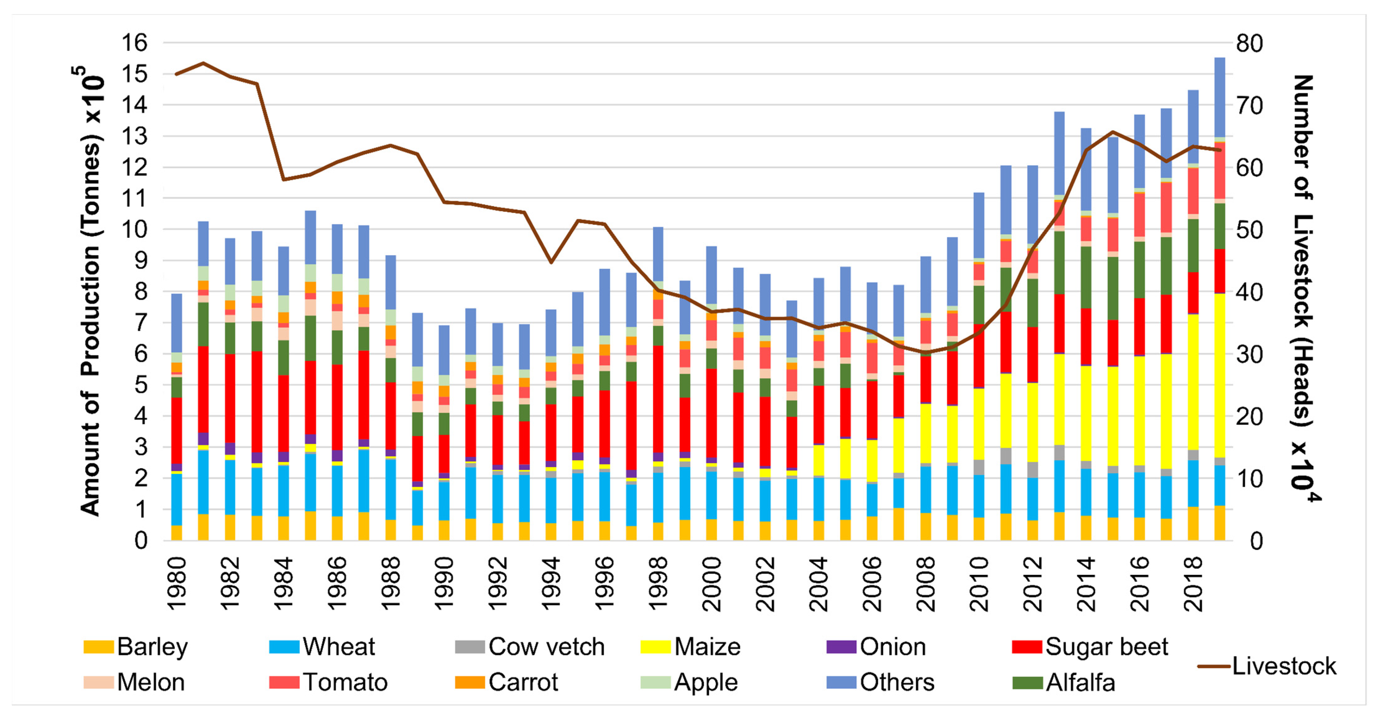
2.2. Agriculture Data

Data on agricultural land area, crop patterns, and biomass production (i.e., crops, vegetables, and fruits) for the period 1980–2019 were obtained from the database of the Turkish Statistical Institute [21]. In addition, remotely sensed land-use data, from the Coordination of Information on the Environment Land Cover (CORINE) (2006 and 2018), were obtained from Copernicus Land Monitoring Service [22] to track land-use changes in the area.

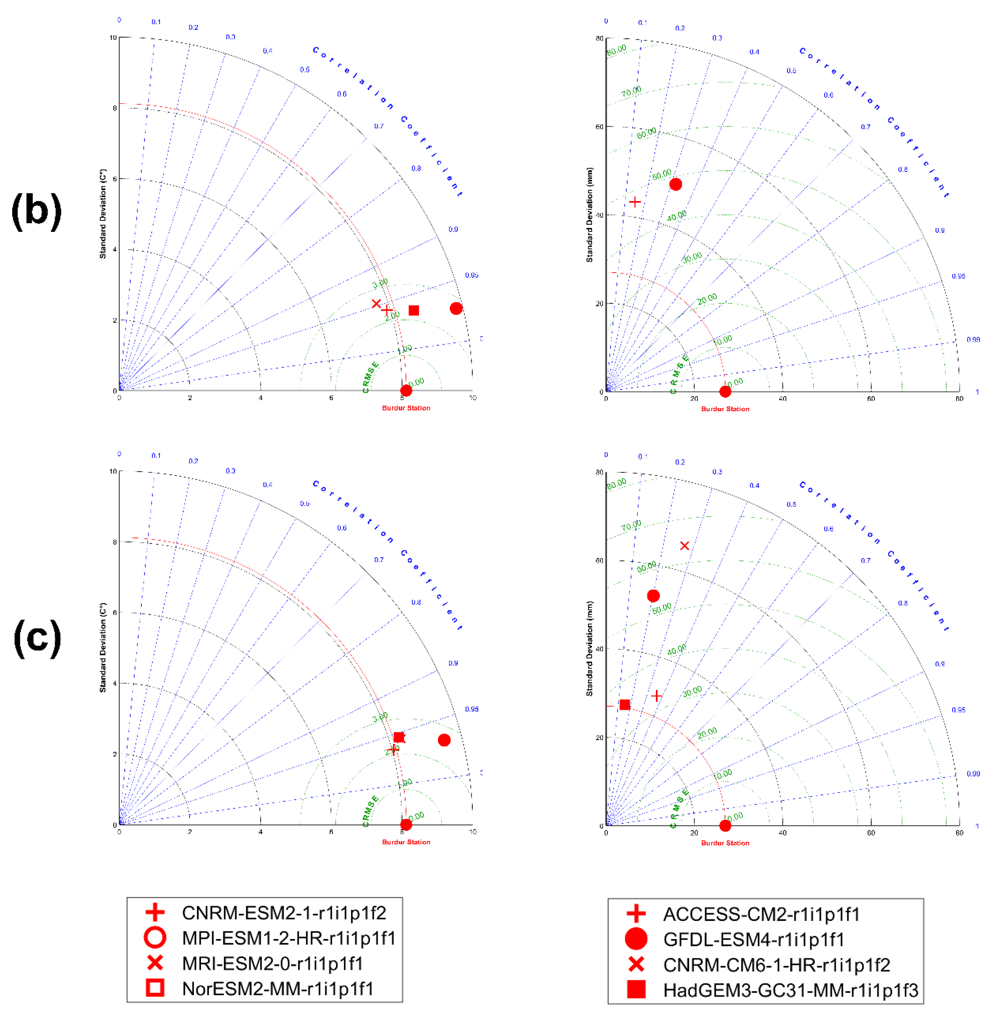
2.3. Hydrometeorological Data and Climate Models

Data on monthly mean temperature and total precipitation were obtained from the Turkish State Meteorological Service [23] for the period 1970–2020. There are two meteorological stations in the BCB (Burdur and Tefenni, located 967 m and 1142 m above sea level, respectively; Figure 1). We only used the data from the Burdur meteorological station as it provides continuous data since 1970. The long-term monthly mean temperature of the basin is 13.2 °C, and the long-term total annual precipitation is 413 mm. After testing for normality and homogeneity of the temperature and precipitation data, a Mann–Kendal analysis and a Şen’s trend analysis [24] were applied.
The water level and surface area of a lake are the key parameters in the Standardized Precipitation Evapotranspiration Index (SPEI) [25,26,27]. Thus, we chose to use the SPEI, a commonly used indicator of hydrological and meteorological droughts [28,29], in our study. We used time scales of 3, 9, 12, 24, 36, and 48 months to determine the interval that best describes the hydrological response of each of the waterbodies. We fitted the time series of the difference between precipitation and potential evaporation (PE) to a three-parameterized, log-logistic probability distribution to consider common negative values. The analyses were performed for wet (May) and dry (September) periods.
The surface water and groundwater levels and mean monthly discharge data in the basin were obtained from the State Hydraulic Works of Turkey (DSI).
We calculated the annual water storage of Lake Burdur since it is the largest lake in the basin and has the largest sub-basin area. We used a simple water balance approach (Equation (1)):
LWL ( t ) = LWL ( t 1 ) + P ( t ) Q obs ( t ) PE ( t )
where annual precipitation (P), observed discharge (Qobs), and lake water level (LWL) data collected for this sub-basin and the PE were calculated using the Thornthwaite equation [30].
Information on the volume of annual surface water for the sub-basins between 1970 and 2020 was obtained from corresponding discharge observation stations. The surface water and the groundwater potentials of the basin are estimated to be 233 hm3/year and 422 hm3/year, respectively, while the total water needed for irrigation in the entire basin is 283 hm3/year [31]. As of 2016, there were 15 dams and reservoirs operating in the basin, mostly for irrigation purposes [32]. The Karamanlı, Karataş, and Karaçal dams have the most significant water potential (Lake Karataş was a natural lake that was dammed in 1982 [33]), and their volumes were 24.8 hm3, 65.3 hm3, and 76 hm3, respectively. These dams are located at the main inflow to Lake Burdur.

2.4. Satellite Data

We used long-life, operational Landsat Legacy satellite imagery data for the long-term monitoring and mapping of the lake surface area. Optical satellite images included 70 (two images for each year, representing dry (August–September) and wet (May–June) periods), non-cloudy Landsat Thematic Mapper (TM) (for 1984 to 2011), and Operational Land Imager (OLI) (for 2013 to 2020) images (30 m ground sample resolution), downloaded from the U.S. Geological Survey’s (USGS) Earth Explorer (www.earthexplorer.usgs.gov, accessed on 20 November 2021). The Semi-Automatic Classification (SCA) plugin in QGIS [34] was used for the radiometric correction of satellite images.

2.4.1. Surface Water Detection

To assign the water pixels, we used the Modified Normalized Difference Water Index (MNDWI), typically used for inland waters as recommended by [35] (Equation (2)). Water class has positive values in MNDWI, unlike soil, vegetation, and built-up classes that have negative values since they reflect more shortwave infrared (SWIR) light than green light. Then, water pixels were digitized to calculate the surface areas of the lakes:
MNDWI = ( ( Green SWIR 1 ) / ( Green + SWIR 1 ) )
where Green and SWIR1 bands sense wavelengths 0.52–0.60 and 1.55–1.75 µm, respectively, for Landsat images.

2.4.2. Vegetation Change Detection

The Normalized Difference Vegetation Index (NDVI) (Equation (3)), which is commonly used to quickly identify vegetated areas and their condition [36], was used to detect live, green plant canopies in Landsat images:
NDVI = ( NIR Red ) / ( NIR + Red )

2.5. Climate Models

A total of eight CMIP6 GCMs previously used for this area [4] were chosen as climate models (MRI-ESM2, MPI-ESM1-2-HR, CNRM-ESM2-1, NOR-ESM2-MM, HADGEM-GC-31-MM, ACESS CM-2, GFDL-ESM4, and CNRM-CM6-1-HR, see Appendix A Table A1). All of the CMIP6 outputs were downloaded using the Earth System Grid Federation (ESGF) LiU datanode (https://esg-dn1.nsc.liu.se/projects/esgf-liu/, accessed on 3 November 2021).
Daily temperature and precipitation data from the CMIP6 outputs were extracted for the Burdur meteorological station. The daily data were converted to monthly values, and the analysis was performed for three periods: the historical period (1970–2014), the validation period (2015–2020), and the future prediction period (2021–2100). For the validation and future predictions, we ran IPCC SSP242 and SSP585 simulations using centered root mean squared error (RMSE), correlation coefficient, and standard deviation, plotted in Taylor diagrams [37]. We corrected temperature data for bias using a simple seasonal bias correction method [38] (Equation (4)):
T Bias   Corrected   ( Model ) = T Model Δ T
where ΔT is the difference between the mean temperature of the climate model and the observations in the corresponding month. The difference between climate model results and observations (monthly data) was subtracted from the raw values of the model to get bias-adjusted temperature values for the historical, validation, and prediction periods.
Biases in the precipitation data were corrected by using the linear scaling method [39] (Equation (5)):
P Bias - Corrected   ( Model ) = P Model ( P - Observation   P - Model )
where P Bias - Corrected   ( Model ) is the bias-corrected monthly precipitation of the model prediction, P Model is the monthly precipitation model value, and P - Observation is the means of the observation and model values for the corresponding month. The ratio between climate model results and observations was multiplied by the model’s raw values to get bias-adjusted precipitation values for the historical, validation, and prediction periods.

2.6. Birds

We used Turkish Breeding Bird Atlas data [40], along with reviewed and confirmed eBird sighting records [41], to present an overview of the breeding avifauna in the basin. Details on the methodology used in the Breeding Bird Atlas are given in Section S1. We consulted the latest assessments of The International Union for Conservation of Nature’s Red List of Threatened Species [42] to check if any breeding bird species were threatened globally. We used the mid-winter waterbird survey database [43], both to present the wintering waterbird community size changes between 1969 and 2020 in the basin and as the main data source for the White-headed Duck and Lake Acıgöl case studies. Section S2 gives a detailed description of the methodology used in the mid-winter waterbird surveys. For the White-headed Duck case study, we supplemented the mid-winter waterbird survey data with records (see Section S3 for a full list of the sources used) from the whole winter season. For the Lake Acıgöl case study, we used body mass, foraging stratum, foraging behavior, and diet functional traits to calculate functional evenness (FEve; [44], an indicator of how evenly the abundances are distributed within the niche space. (See Section S4 for more information on the traits chosen and the sources used to score them.) We then used generalized linear models (GLM; [45]) to check for temporal trends in FEve. Finally, we used BirdLife International’s Important Bird Area (IBA) data zone [46] to review the states of the IBAs in the basin.

2.7. Fish

We collected information on fish species and their distribution and population status in the BCB from a wide range of literature [47,48,49,50,51,52,53,54,55,56]. The validity of the fish names was checked using FishBase [57] and the Catalog of Fishes [58]. The conservation statuses of the species were obtained from the IUCN’s Red List [42].

3. Results

3.1. Changes in Land and Water Use

In 2019, 43.6% (1753 km2) of the land in the BCB was cultivated [59]. As 956 km2 (54.5%) of this cultivated land belongs to the Burdur sub-basin, we used the crop production in this sub-basin as an example of that of the whole basin (Figure 2). The main products in 2019 were maize, tomatoes, alfalfa, sugar beets, wheat, and barley, which constituted 34, 11.6, 9.4, 9, 8.3, and 7.2% of total production, respectively (Figure 2) [21]. While the production fluctuated between 7 and 10 × 105 tons per year from 1980 to 2007, it has increased since then to 15 × 105 tons in 2019. The establishment of a new fodder-crop factory and the distribution of government-supported maize-gathering machines led to an increase in maize and alfalfa production after 2004 ([60], Figure 2). The increase in the production of the water-thirsty maize, and also alfalfa, mainly served the purpose of feeding an increasing number of livestock. Accordingly, livestock increases largely followed the agriculture trends during the most recent 10-year period (Figure 2).
The CORINE land-use data indicated no major change in irrigated land for crop farming between 2006 and 2018, whereas the crop pattern has markedly changed. Thus, the CORINE maps revealed a 3% decrease in the wetlands and water bodies, an increase of 30% in urbanized areas and mineral extraction sites, and a decrease of 22% in shrub land from 2006 to 2018 (Figure 3a,b).
Crop farming in the BKB was intense, particularly southwest of Lake Karataş and northeast of Lake Burdur (Figure 3c,d). High NDVI values (red color in Figure 3c,d) indicated that the increase in irrigated areas corresponded to cultivated crops from 2006 to 2018 (Figure 3c,d).

3.2. Change in Surface-Water and Groundwater Resources

The water requirement for irrigation in the basin was estimated at 253 hm3/year, 43% of which was obtained from surface water and the rest from groundwater in 2018 [31]. The use of groundwater for irrigation purposes differed in intensity among the sub-basins: 80% in the Yarışlı, Acıgöl, and Akgöl sub-basins, and less than 30% in the Burdur, Salda, and Atabey sub-basins. In the sub-basins having the least surface water, the use of groundwater became high, especially after 1992, and declines in the groundwater levels have been observed [31]. The amount of water needed for domestic supply and industrial use is comparatively small (24.5 hm3/year and 4.9 hm3/year, respectively) [31].

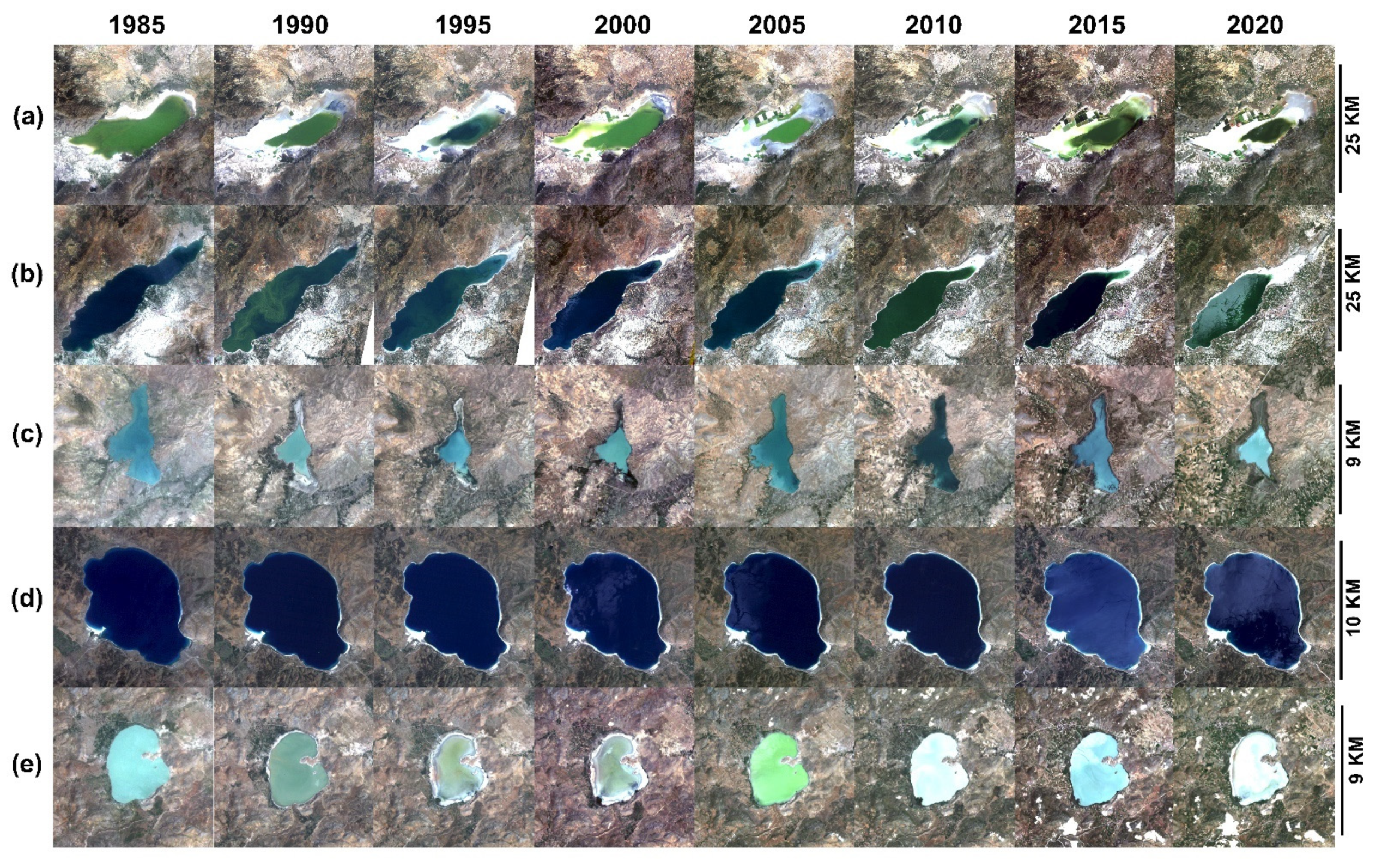
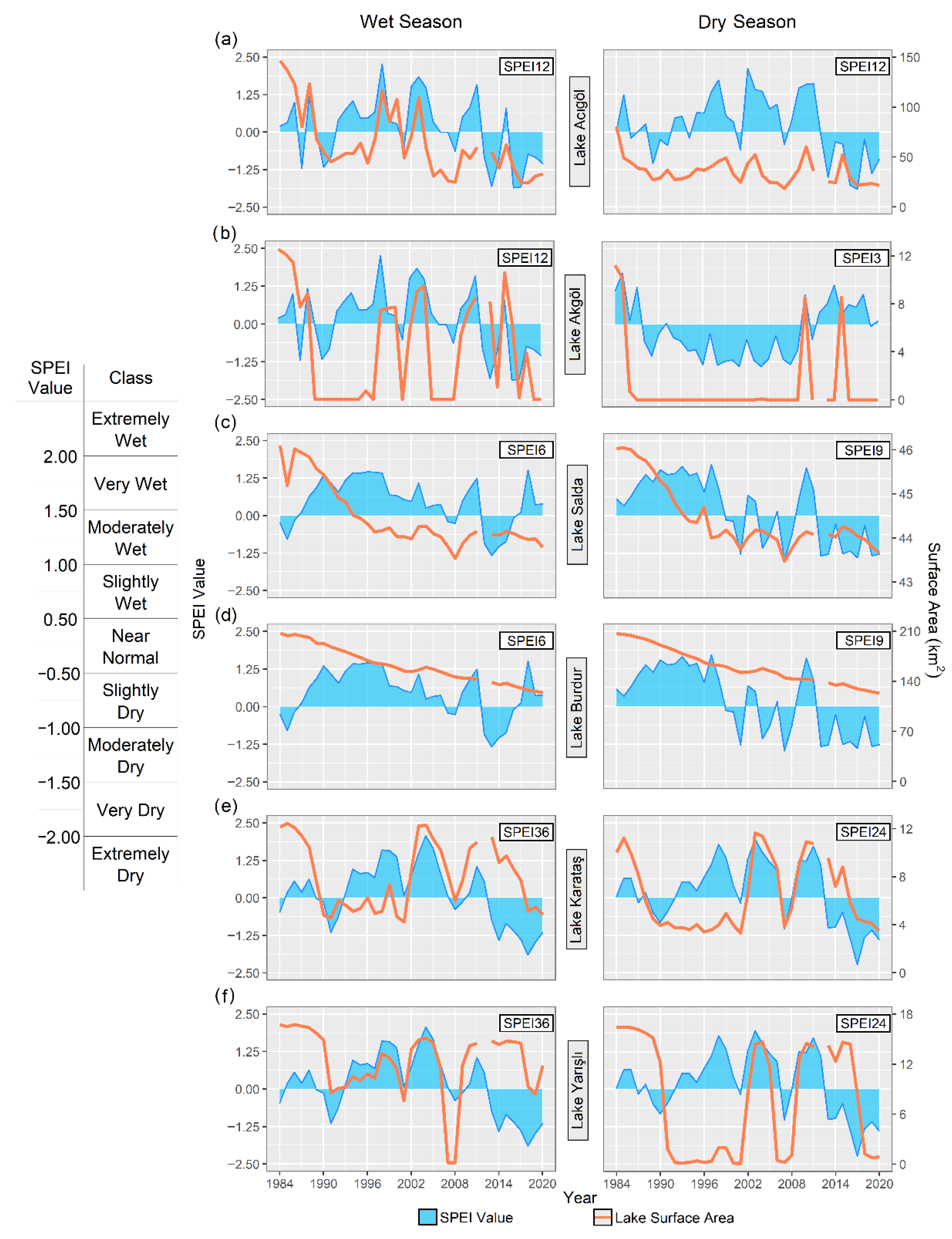
3.3. Change in Lake Surface Areas

The surface areas of Lakes Acıgöl, Akgöl, Burdur, Karataş, and Yarışlı decreased drastically, whereas this was not the case in deep Lake Salda (Figure 4). (In Figure 4e, the surface-area change of Lake Yarışlı is not easy to observe in True Color Images, but MNDWI results indicate a state of complete drought in Lake Yarışlı).
The SPEI for 12-month periods (SPEI-12) correlated best with the surface area of wet and dry seasons of Lake Acıgöl and the wet season of Lake Akgöl. SPEI-3 had the best correlation with the dry season of Lake Akgöl. For Lakes Burdur and Salda, SPEI-6 and SPEI-9 were best correlated with the surface area for the wet and dry seasons, respectively. For Lakes Karataş and Yarışlı, SPEI-36 was best correlated with the wet season and SPEI-24 with the dry season (Figure 5).
A major decrease in the surface area of Lake Acıgöl occurred after 2005 in the wet season according to the SPEI changes (Figure 5a). Thus, the Acıgöl SPEI values for the 1986–2006 wet seasons corresponded to moderately wet conditions, followed by dry conditions from 2012 to 2020. For the dry season, the surface water of the lake started to decrease after 1984, and since then, it has ranged between 20 and 50 km2.
Lake Akgöl was completely dry from 1988 to 2009 during the dry season, as indicated by the extremely low SPEI values. From 2010 to 2015, positive SPEI values indicated wet conditions, but apart from two peaks corresponding to extreme precipitation events, the lake was dry (Figure 5b).
The surface area of Lake Burdur has decreased during both the wet and dry seasons since 1984 (Şen’s slope: −2.231, p < 0.05) (Figure 5c), and a similar decreasing trend was evidenced for Lake Salda (Figure 5d).
Lakes Karataş and Yarışlı showed similar changes in SPEI (Figure 5e,f), and in both cases the positive SPEI values are not related to an increase in the surface area of the lakes. Lake Yarışlı has dried out, or almost dried out, for a prolonged period during the dry season.

3.4. Changes in the Bird and Fish Communities

The major changes in the lake area in the BCB have led to substantial changes in the biota, which we elucidated by focusing on the threats to waterbirds and fish.

3.4.1. Birds

The BCB is home to 106 bird species with either probable or confirmed breeding records and 55 more with possible breeding records. Of these, five species are included in the IUCN red-list as globally threatened [42]. The six IBAs in the BCB have had worsening scores and conditions, and half are listed among IBAs in danger, which are IBAs under intense pressure, requiring urgent action [61,62].
Over the last 50 years, the wintering waterbird population size has shown a significant negative trend (Figure 6; negative binomial GLM with log link; effect size estimate for year: −0.394, SE: 0.159, p-value: 0.013). The BCB harbored more than 360,000 waterbirds in the late 1960s, making it one of the most important waterbird wintering sites in Turkey, but for 2015–2020, the average declined to only 26,000 for the whole basin.

3.4.2. Fish

The BCB has the second-highest fish endemicity (54%) after the Konya Closed Basin (74%) [12], with 13 of the 24 fish species being endemic. In addition, the BCB has non-native fish species: four introduced (Cyprinus carpio, Knipowitschia caucasica, Sander lucioperca, and Silurus glanis) and seven invasive (Carassius gibelio, Clarias gariepinus, Coptodon zillii, Gambusia holbrooki, Hemichromis letourneuxi, Oreochromis niloticus, and Pseudorasbora parva). Of the 13 endemic fish species, 7 are categorized as threatened: 2 as critically endangered and 5 as endangered [63]. Endemic fish species populations in the BCB basin have declined in recent decades [48,49,53,64], mainly due to significant loss of lakes and streams, climate change, water pollution [47], and the invasion of non-native species [54].
The Anatolia region is a hotspot for the diversity of the killifish family (Aphaniidae), a euryhaline group that tolerates changes in salinity and can live in both fresh and brackish waters [65,66]. Many species of the Anatolichthys genus have a limited distribution in the BCB, with some species restricted to only a few springs or lakes, such as Anatolichthys transgrediens, which is only found in Lake Acıgöl during the spring [48], Anatolichthys saldae, which is only found in Lake Salda, and Anatolichthys sureyanus, which only occurs in Lake Burdur [51]. The endangered A. sureyanus has been highlighted as being under threat due to massive water abstraction and damming [48,63].

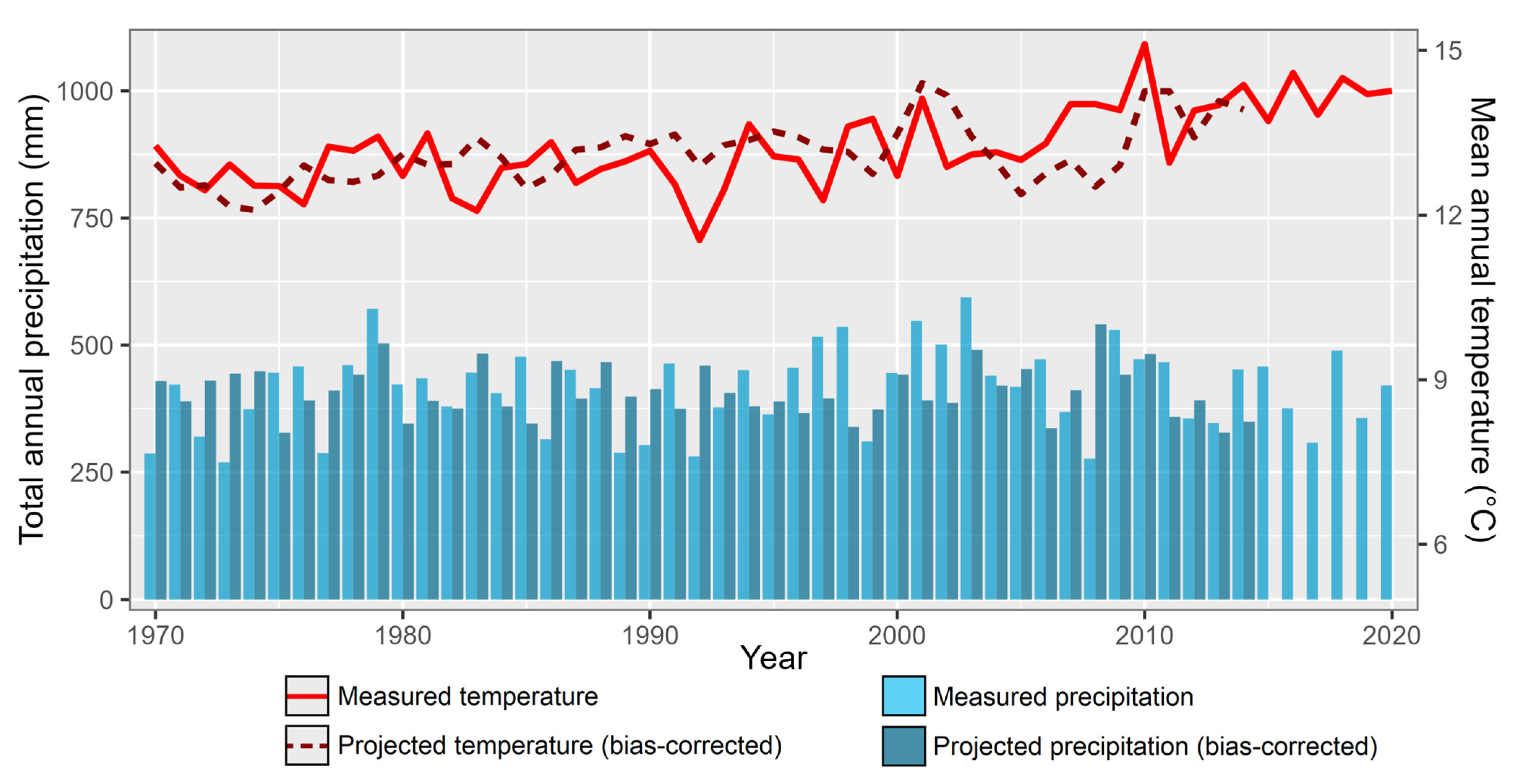
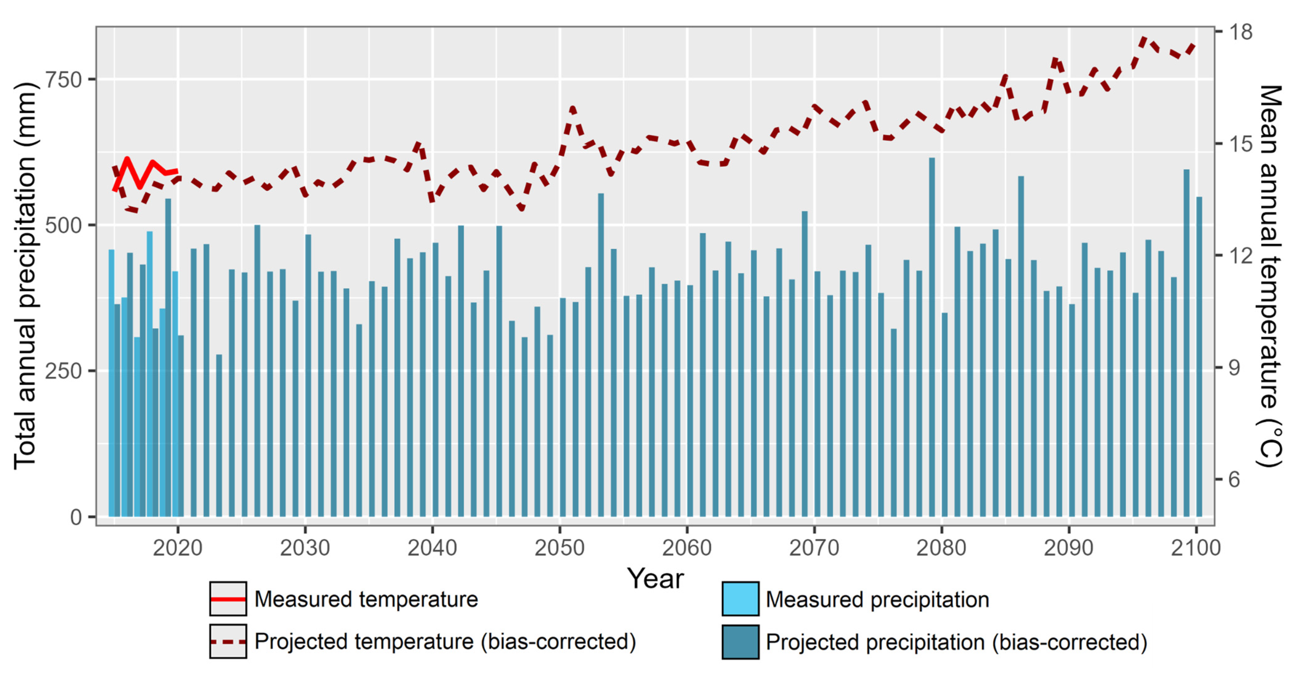
3.5. Future Predictions of Temperature and Precipitation

Mann–Kendal and Şen’s trend analyses indicated an increase in annual mean air temperatures (0.012 °C/year) (Figure 7), but there was no significant trend in precipitation. Moreover, open surface evaporation showed an increasing trend of 6 mm/year for the basin [31].
CNRM-ESM2-1 GCM data on temperature and GFDL-ESM4 GCM data on precipitation were selected for predictions as the model results fit best with the observations for the Lake Burdur sub-basin. Taylor diagrams showing the performance of the climate model results are given in Appendix A Figure A1. The annual mean temperature and precipitation data, before and after bias correction with the observations, are given in Figure 7.
The climate model (CNRM-ESM2-1 GCM) indicates that in 2100 the long-term average (1970–2100) annual mean temperature will be 14.38 °C. This is 1.18 °C warmer compared to the long-term average mean annual temperature for 1970–2020 of 13.2 °C. Total annual precipitation is predicted to increase by 2% in 2100 from 413 mm (1970–2020) to 422 mm (1970–2100). Long-term potential annual evaporation is estimated to increase to 1626 mm for 2100 as compared to 1432 mm for 2020 (Figure 8).

3.6. Case Studies

To illustrate the severity of the ecological changes that the BCB is facing, we provide three case stories on: (1) the hydrological change of Lake Burdur, (2) changes in bird and fish communities in Lake Acıgöl, and (3) the globally endangered White-headed Duck in the BCB.

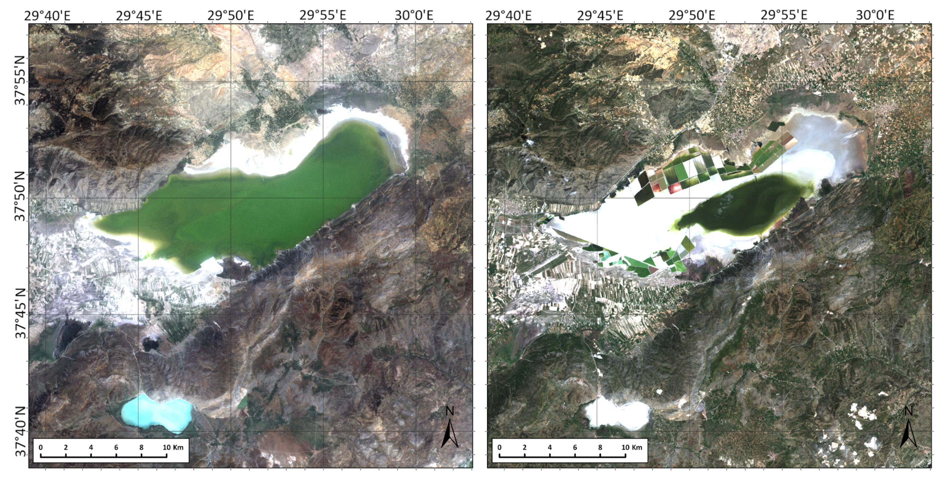
3.6.1. Witnessing the Dry-Out of Lake Burdur

Lake Burdur has a basin area of approximately 3185 km2, an average lake depth of 40 m, and a maximum depth ranging between 68 and 110 m. The maximum surface area of Lake Burdur was 206 km2 in 1985 (Figure 9a). The lake receives water from seasonal and perennial streams, groundwater, and rainfall. The water balance of Lake Burdur based on water level recordings since 1970 showed good correspondence between the observed and modeled lake volumes (Figure 9c).
Several dams had already been built before 1994 [67]. These dams collectively retained 31.17 × 10⁶ m3 water per year. The biggest dam built on the inflow is the Karaçal Dam. Between 2000 and 2010, small reservoirs were constructed on the rivers, also contributing to the lake’s shrinkage.
The budget analysis for Lake Burdur revealed a decreasing trend in volume with time. The depth–volume curve indicates a depth of 841 m (mean sea level), corresponding to 4000 hm3 volume by the end of 2045. Below 841 m, the side slopes of the lake are steep and without pronounced shallow areas. Since the mean annual temperature, and thus evaporation, is predicted to increase, the lake is predicted to dry out by the end of the century even if the water use in the lake basin remains the same (Figure 9c).
The SPEI values calculated from the temperature and precipitation data obtained from the climate models indicate slightly dry periods after 2050 and extremely dry periods after 2075 (Figure 10). The duration of negative SPEI values were more pronounced for the dry than the wet periods (Figure 10b), indicating that long-term droughts are likely to occur in Burdur Lake from 2090.
Lake Burdur is an alkaline lake, with high salinity and high ion concentrations [68], reflecting the absence of outflows. The projected increased evaporation not compensated by precipitation, along with the expected increase in water use, will lead to an increase in the concentration of these salts and ions, and therefore an increase in salinity, with the consequent effects on ecosystem services and functions, including the support of biodiversity.

3.6.2. Lake Acıgöl

Lake Acıgöl is an endorheic, hypersaline soda lake situated in a tectonic depression. The lake receives spring water primarily characterized by high Na2SO4 and NaCl values, with a total flow of 1140 L/s [69] that enters the lake from a fault line on the southern side (Figure 11). Lake Acıgöl is the source of more than 85% of the anhydrous Na2SO4 production of Turkey (400,000 tons in the late 1990s) [70]. The lake had a surface area of 160 km2 and a maximum depth of 8 m until the mid-1970s before the soda production operations started in the region [71]. Between the late 1970s and late 1980s, the lake surface area decreased by 75%, and the permanent water level has dropped more than 10 m since 1971 when the salt factories opened up [72,73]. Figure 11 shows the decrease in the lake’s shoreline and the increase of the factories between 1984 and 2020. A major inlet to the lake was diverted for use in anhydrous Na2SO4 and Glauber salt extraction (60,000 tons/yearly). In addition, the major chemical factories around the lake used 25 million m3 water per year for the extraction process [74]. Furthermore, the increased use of the southern springs for irrigation and domestic purposes, especially after the 2000s, contributed to the lake’s shrinkage [69].
Lake Acıgöl is an important breeding, wintering, and stopover site for many bird species. Thus, regionally important numbers of Greater Flamingos (Phoenicopterus roseus) and the globally threatened Great Bustards (Otis tarda) inhabit the lake [67]. The analyses of mid-winter waterbird censuses did not reveal any significant trend in the species richness of the wintering bird population between the 1960s and 2019 although there was a slight negative effect of the year (negative binomial GLM with log link, effect size estimate: −0.365, SE: 0.199, p-value = 0.067). However, the abundance of the total wintering waterbird communities (−0.397, SE: 0.165, p-value = 0.016) and the functional evenness of the wintering waterbird communities have declined significantly over the last 51 years (gamma GLM with log link, effect size estimate: −0.272, SE: 0.060, p-value < 0.001).
The springs of Lake Acıgöl are also an important migration and wintering site for the endemic and threatened Acıgöl toothcarp Anatolichthys transgrediens [47,51]. During heavy rainfalls, when the salinity concentration is low, A. transgrediens can be found near the shores, especially in the southern part of the lake [47,66]. A. transgrediens populations have declined dramatically, and the species is currently listed as Critically Endangered [51,63]. The loss of habitat around the lake, as a result of reduced rainfall, water abstraction, and drying springs, has negatively impacted the species [75]. Furthermore, Mosquito fish (Gambusia holbrooki) were introduced by the end of the 1990s and had a significant impact on the native and endemic species, probably mainly due to resource competition and predation of the juveniles. Also, negative impacts on a variety of other animals, such as frogs and macroinvertebrates [66,76], were observed. It has been reported that this non-native species could affect the trophic levels of the ecosystem [77,78].

3.6.3. The Fall of the Endangered White-Headed Duck in the Burdur Basin

The White-headed Duck (WHD) is a globally endangered, diving duck [79,80]. It is an iconic bird in the basin, and there used to be a bird festival in Burdur province until the mid-2000s [67] as Lake Burdur harbored the majority of the global population during the winters of the early 1990s [81,82]. Back then, several thousand WHDs regularly wintered in the lake, and the numbers reached a peak of 10,927 in 1991, corresponding to 58% of the global population ([81]; Figure 12). Other lakes in the basin, including Lakes Acıgöl, Akgöl, Karataş, Salda, and Yarışlı, supported a total of nearly 1500 wintering WHDs until the late 1990s [43]. A relatively small wetland southwest of Lake Burdur and Soğanlı Marshes had a breeding population of 2–3 pairs in the late 1990s [83]. Outside the breeding and wintering periods, in the migration and post-breeding periods, up to a few thousand WHDs could also be found in the basin, mainly in Lake Burdur [84].
Following the water level decline in the lake, wintering WHD numbers in the basin started to decrease dramatically. In 2019, there were only 18 wintering WHDs left in the lake and its basin, and none in 2020 [43]. Multiple factors seem to have contributed to this decline. First, when the lake started to shrink, the northern and shallowest part of the lake dried out [14]. This part was particularly important for waterbirds, including the WHD [83]. The remaining southern parts of the lake have a steeper morphometry and offer limited amounts of shallow areas for waterbirds [14]. The loss of the shallow areas seems to have been the biggest contributor to the decline of the WHD population, considering that most WHDs were found there earlier [81]. Water level declines in the other lakes in the basin may also have contributed to the regional decline of the wintering population. Secondly, the loss of the shallow areas and increasing salinity may have decreased the capacity of the lake to support chironomids, which are the main food sources of WHDs [80]. Chironomid abundance in the lake was found to increase steadily up to and peak at around 10 m and decreased steeply at higher depths [85]. Studies have shown that high salinity levels can decrease the growth rate, survival, size, and emergence rate of some chironomid species [86,87] as well. Taxonomic studies have also confirmed an overall decrease in the diversity of benthic macroinvertebrates, including chironomids, between the late 1980s and mid-2000s [88]. Furthermore, the once-high hunting pressure in Lake Burdur may have contributed to the decline of the WHD population. Even when the lake was declared a no-hunting zone, around 4.5 WHDs per day were estimated to have been shot in only one-quarter of the lake, which was well over the sustainable limit [81]. In the winter of 1992–1993 alone, at least 1000 WHDs were estimated to have been shot [89]. Finally, declines in the regional and national breeding populations [82] likely also contributed to the decline, showing the effects of multiple stressors in addition to the water loss effects.

4. Discussion

4.1. Change in Lake Surface Area and Water Budget of the Largest Lake in the Basin

We used remote sensing and hydrometeorological data to understand the change in lake surface areas in the Burdur Basin and the water budget of the largest lake in the basin. Especially in closed basins, the expansion and reduction of lakes are important indicators of the regional climate conditions and the local hydrological cycle. We used Landsat images dating back to 1985 and the SPEI values calculated from meteorological data to describe the decadal changes in the surface area of the lakes in the BCB (Figure 4). The trend analyses of temperature and rainfall observations at the Burdur meteorological station from 1970 to 2020 revealed an increasing temperature in the basin, while precipitation has exhibited no significant trend. Accordingly, the water loss from the basin has increased due to enhanced evaporation and transpiration, as also evidenced by the observed negative SPEI values after 2000. Historical and current Landsat images showed a great shrinkage of almost all of the lakes in the basin, except for deep Lake Salda, from 1984 to 2020 (Figure 4). The relation between SPEI and surface areas showed a response time of 6–9 months for precipitation anomalies of the deep Lakes Burdur and Salda, indicating that the changes in mean surface area mostly depended on the meteorological events. The Lakes Acıgöl and Akgöl had a longer response time (12 months) and mostly interacted with groundwater and streamflow, while Lakes Yarışlı and Karataş had the highest response times (>24 months), which is generally the case for lakes used for irrigation purposes [14] (Figure 5).
As in the nearby, large Konya Closed Basin (KCB), a key factor driving the water loss in the lakes is the unsustainable use of water for agriculture. Crop production in the BCB increased from 7 × 10⁵ tons per year during the 1980s to 10 × 105 tons per year in 2007, and later to 15 × 105 tons per year in 2019. The increase in crop production was especially caused by the production of water-thirsty crops, maize, soy, and alfalfa, which has increased since 2004 [60], thereby substantially augmenting the use of water in agriculture (Figure 2). In KCB, production has increased 2-fold since 2000, especially due to the enhanced production of maize and sugar beets, this increase being mirrored in the groundwater tables where major drops have been observed in most of the basin [12]. A yearly irrigation-induced water deficit of almost 350 hm3 in the KCB has led to water importation from neighboring catchments (e.g., the Blue Tunnel Project involving the transfer of water from the Göksu catchment to the Konya Plain) [60]. Such compensatory importation is well-known from other arid regions (e.g., [10]) but has negative consequences for the lakes in the exporting catchments, an evident example of this being the iconic Aral Sea [90].
The climate projection models for the BCB furthermore predict an increase in annual mean temperature of up to 1.18 °C, an increase in annual precipitation of 10 mm per year, and an increase in the potential annual evaporation of 200 mm per year. The temperature increase concurs with previous climate change modeling results for the basin, mostly based on CMIP5. However, in contrast to the CMIP5 model results, CMIP6 predicts a slight increase in annual precipitation; however, this does not compensate for the expected increase in loss by evapotranspiration. We used the CMIP6 model as it was the best to describe the recent changes in Lake Burdur and predicted warmer annual temperatures than CMIP5, and our results suggest that, after 2070, the BCB will face long-term, moderate-to-severe dry periods. The budget analysis of the lake and the projected SPEI values show that there is a high risk that the lake may entirely disappear (the third-deepest lake in Turkey) in the medium 12 rm (2045–2070) due to excessive evaporation and water abstraction for irrigation (Figure 9). Also, Lake Acıgöl faces great shrinkage, in part because its water balance is highly controlled by the water use in the salt and sulfate factories around the lake. A simulation for Lake Beyşehir in KCB, Turkey’s largest freshwater lake for which different climate models predicted a complete dry-out during the next 20–60 years if the current water use regimes continue, suggests that a reduction in water use of up to 60% is needed to avoid this [12,60]. Thus, a grim future is on the horizon for the lakes in the central plains of Turkey with a “business as usual” approach to irrigated crop farming.

4.2. Changes in Waterbird Communities and Aquatic Habitats in the Basin

Despite the drastic habitat loss and degradation that the BCB has been experiencing over the last several decades, it still exhibits an astounding bird diversity. All IBAs in the basin, which contain the majority of the populations of these globally threatened birds [67], have deteriorating conditions and declining populations. The dramatic wetland habitat losses and degradation have also resulted in a steep decline in waterbird numbers in the basin, including the enigmatic White-headed Duck. We anticipate that the contributions of the wintering range will shift due to global climate change [91,92], and the global and regional population declines that some of the waterbirds have experienced [93] are minor compared to the effects of water drainage and habitat degradation. Thus, the range shifts are not likely to have resulted in huge declines in total community size because waterbird species respond differently to climate change. Some species have shown no range shift at all [92], as indicated by the absence of steep declines in other long-term datasets in Turkey [94]. The decreased FEve of the wintering waterbird communities at Lake Acıgöl may have caused the deterioration of fundamental community functions [95]. A less-even distribution of abundance within the functional space implies that some parts of the niche space are under-utilized (although part of the niche space is occupied), which may decrease the overall stability and resilience due to less optimal resource use and weaker species complementarity [95,96].
Habitat degradation and loss driven by the water deficit of lakes in the BCB has led to a drastic impact on bird populations in recent decades, decreasing by 93% from the late 1960s to the period 2015–2020. In particular, the loss of the more sensitive shallower areas of these lakes threatens those species that depend on the habitat or food resources these areas provide, as in the case of the White-headed Duck. Furthermore, water loss increases the salinization, which impacts various communities, such as the macroinvertebrates and plants that serve as food for waterbirds. Even more dramatic changes have occurred in the KCB [12]. Here, a comparison of two bird atlases (from 1998 and 2018) indicated a widespread decline in the species richness of breeding waterbirds in the whole basin, with a loss of 18 species, and the total breeding waterbird richness has declined by 23% (from 62 to 48 species), and 76% of the species that no longer breed in the KCB were Red-Listed on the national scale in the 2004 assessment. In addition to preventing their hunting, specific measures to reduce the consumption of water from these lakes require urgent action to avoid the total collapse of waterbird populations in the BCB. In particular, in the face of climate change scenarios that can accentuate the effects of water abstraction, accelerating the water loss and salinization of these lakes.
Impacts related to water deficits and salinization have also been observed in fish in the BCB. Since endemic freshwater fish species are often distributed over small areas, they are the most vulnerable group of vertebrates to anthropogenic impacts [97,98]. Lakes and streams in the BCB are currently being affected by habitat loss and modification, as well as by the introduction of non-indigenous species [49,99]. Endemic BCB fish species, particularly Anatolichthys and Pseudophoxinus populations, are currently declining [48,49,52]. Concerning the native and endemic fish species in the BCB, it is notable that the reduction of native fish populations and the increase of threatened species place the native fish species in restricted areas with poor water quality. Here, the non-native species can persist, tolerate, and sometimes thrive under an exceptional range of environmental conditions, displaying a high reproductive potential and becoming predators of native species. Non-native invasive species have impacted the natural habitats of almost all endemic species in the BCB [53]. However, biological (reproductive and trophic aspects) and ecological (population and community aspects) information on the native and endemic species of the BCB, as well as on their interactions with non-native species, is still scarce, hampering the development of optimal conservation guidance for the species.

4.3. Management Perspectives

That changes in land use and irrigation rather than climate have had the most devastating effects in semiarid and arid areas worldwide in recent decades is well established (e.g., [10,100]) and clearly illustrated also when combing the results of the studies of the BCB and the KCB (in the present paper and [12]). The water deficit in the BCB and the KCB may be further affected by the intensification of agriculture. With the current agricultural policies, the crop production will likely continue to increase as in the past 20 years to satisfy the demand of an increasing human population. The war scenarios of the early 2020s in the region might further accentuate the needs for higher crop production, increasing even more the water abstraction and thus its environmental impacts. Left uncontrolled, the production of thirsty crops, especially that of fodder crops such as maize and alfalfa in the BCB, will likely increase, leading to higher demands for water [101]. To ensure effective use of the water in the basin, switching to water-saving irrigation methods and the planting of crops suitable for the climate and water potential of the area through regional-level action is highly needed [102]. If the demand for water remains at its current level or increases to meet irrigation needs, the groundwater table will drop further, and so will the lake levels, and therefore the potential of these lakes to support their functions and services, including irrigation. Given these and the projected increases in temperature and surface evaporation, the capacity of the basin to support waterbirds and endemic fish species might decline further in the future. The intense pressure on the BCB aquatic habitats has already resulted in a dramatic decline in the populations and range sizes of many waterbird and fish species [55,103]. Many endemic species have been restricted to isolated refuge habitats, such as springs and spring-fed streams, causing extreme limitation of dispersal. Therefore, immediate protection of these refuge areas, effective mitigation of current pressures, and restoration of native aquatic habitats in the BCB are critically important for the endemic fish fauna as well as for the iconic water birds (e.g., White-headed Duck, Flamingo) of the BCB. If these pressures remain at their current intensities, the local extinction of fish populations may be imminent. Restoring healthy and resilient ecosystems, with sustainable water use practices and strict control of invasive species, are a priority for maintaining the fish fauna of the BCB with its high endemism as well as habitat suitability for waterbird populations.
To reverse the ecosystem degradation or even preserve the current status, there is an urgent need for a policy framework that aims to restrict the exploitation of water resources within sustainable limits while simultaneously promoting conservation efforts. This seems achievable only if the basin-wide legal regulation of water abstraction is combined with economic incentives for the transition to climatically appropriate crop farming.

Supplementary Materials

The following supporting information can be downloaded at: https://www.mdpi.com/article/10.3390/w14081241/s1, Section S1: Breeding Bird Atlas Methodology, Section S2: Additional Sources Used for the White-headed Duck Case Study, Section S3: Mid-winter Waterbird Survey Methodology, and Section S4: Functional Diversity & Statistical Analyses. References [104,105,106,107,108,109,110,111,112,113,114,115,116,117,118,119,120,121,122,123,124] are cited in the supplementary materials.

Author Contributions

Conceptualization: E.J., Z.A., M.B. and K.Ö.; methodology, software, validation, formal analysis, and investigation: M.A.Ç., B.Ö., Z.A., İ.K.Ö., M.S., M.M. and M.K.; resources: E.J.; data curation: M.A.Ç., B.Ö., Z.A., İ.K.Ö., M.S., M.M., M.K. and G.Y.; writing—original draft preparation: M.A.Ç., B.Ö., İ.K.Ö., M.S., M.K., A.R.-G., M.M., G.Y., S.E., Ü.N.T., C.A.A., C.Ö., M.A.Y., A.Y., J.P.P., K.Ö., M.B., E.J. and Z.A.; writing—review and editing: M.A.Ç., B.Ö., İ.K.Ö., M.S., M.K., A.R.-G., M.M., G.Y., S.E., Ü.N.T., C.A.A., C.Ö., M.A.Y., A.Y., J.P.P., K.Ö., M.B., E.J. and Z.A.; visualization: M.A.Ç., B.Ö., Z.A., İ.K.Ö. and M.S; supervision: K.Ö, M.B., Z.A. and E.J.; project administration: K.Ö., M.K., M.M. and E.J.; funding acquisition: E.J. All authors have read and agreed to the published version of the manuscript.

Funding

The project and E.J., G.Y., M.M., M.A.Ç., S.E., C.A.A., and M.K. were supported by TÜBİTAK program BIDEB 2232 (project 118C250). M.B. and E.J. were supported by EU—H2020, INFRAIA project AQUACOSM-Plus (No. 871081). Z.A. and M.B. were also funded by the EU H2020-funded PONDERFUL project (No. 869296). KÖ was supported by TÜBA-GEBİP.

Data Availability Statement

The data are available from the authors on reasonable request.

Acknowledgments

We thank the General Directorate of Nature Conservation and National Parks for providing the mid-winter waterbird survey data and all of the 2018 atlas volunteers and the atlas team for the collection of the breeding bird atlas data. We also thank the OSME and Mohamed bin Zayed Species Conservation Fund for funding the İKÖ’s 2016 and 2019 White-headed Duck projects. We are grateful to Anne Mette Poulsen for manuscript assistance, Tamer Yılmaz for up-to-date information about some of the investigated sites, and Beril Tezel for the White-headed Duck drawing. We acknowledge the World Climate Research Program, which, through its Working Group on Coupled Modelling, coordinated and promoted CMIP6. We thank the climate modeling groups for producing and making their model output available, the Earth System Grid Federation (ESGF) for archiving the data and providing access, and the multiple funding agencies that support CMIP6 and ESGF.

Conflicts of Interest

The authors declare no conflict of interest.

Appendix A

Table A1. Global circulation models.
Global Circulation ModelEnsembleHistorical SimulationFuture SimulationParameter
SSP 245SSP 858
CNRM-ESM2-1r1i1p1f2+++Near-surface air temperature
MPI-ESM1-2-HRr1i1p1f1+++Near-surface air temperature
MRI-ESM2r1i1p1f1+++Near-surface air temperature
NOR-ESM2-MMr1i1p1f1+++Near-surface air temperature
ACCESS CM-2r1i1p1f1+++Precipitation
GFDL-ESM4r1i1p1f1+++Precipitation
CNRM-CM6-1-HRr1i1p1f2+NA+Precipitation
HADGEM-GC-31-MMr1i1p1f3+NA+Precipitation
Figure A1. Taylor diagrams for temperature and precipitation comparison for the historical period (1970–2014) (a); the validation period (2015–2020) of R245 simulation (b); and the validation period (2015–2020) of R585 simulation (c).
Water 14 01241 g0a1aWater 14 01241 g0a1b

References

  1. IPCC Climate Change 2014: Synthesis Report. Contribution of Working Groups I, II and III to the Fifth Assessment Report of the Intergovernmental Panel on Climate Change; Core Writing Team; Pachauri, R.K.; Meyer, L.A. (Eds.) IPCC: Geneva, Switzerland, 2014; p. 151. [Google Scholar]
  2. IPCC Climate Change 2021: The Physical Science Basis; Masson-Delmotte, V.; Zhai, P.; Pirani, A.; Connors, S.L.; Pean, C.; Berger, S.; Caud, N.; Chen, Y.; Goldfarb, L.; Gomis, M.I. (Eds.) Contribution of Working Group I to the [IPCC Sixth Assessment Report|Sixth Assessment Report] of the Intergovernmental Panel on Climate Change; Cambridge University Press: Cambridge, UK, 2021; in press. [Google Scholar]
  3. Barcikowska, M.J.; Kapnick, S.B.; Krishnamurty, L.; Russo, S.; Cherchi, A.; Folland, C.K. Changes in the Future Summer Mediterranean Climate: Contribution of Teleconnections and Local Factors. Earth Syst. Dyn. 2020, 11, 161–181. [Google Scholar] [CrossRef] [Green Version]
  4. Bağçaci, S.Ç.; Yucel, I.; Duzenli, E.; Yilmaz, M.T. Intercomparison of the Expected Change in the Temperature and the Precipitation Retrieved from CMIP6 and CMIP5 Climate Projections: A Mediterranean Hot Spot Case, Turkey. Atmos. Res. 2021, 256, 105576. [Google Scholar] [CrossRef]
  5. Rodríguez Díaz, J.A.; Weatherhead, E.K.; Knox, J.W.; Camacho, E. Climate Change Impacts on Irrigation Water Requirements in the Guadalquivir River Basin in Spain. Reg. Environ. Chang. 2007, 7, 149–159. [Google Scholar] [CrossRef]
  6. Yano, T.; Aydin, M.; Haraguchi, T. Impact of Climate Change on Irrigation Demand and Crop Growth in a Mediterranean Environment of Turkey. Sensors 2007, 7, 2297–2315. [Google Scholar] [CrossRef] [Green Version]
  7. Jeppesen, E.; Brucet, S.; Naselli-Flores, L.; Papastergiadou, E.; Stefanidis, K.; Nõges, T.; Nõges, P.; Attayde, J.L.; Zohary, T.; Coppens, J.; et al. Ecological Impacts of Global Warming and Water Abstraction on Lakes and Reservoirs Due to Changes in Water Level and Related Changes in Salinity. Hydrobiologia 2015, 750, 201–227. [Google Scholar] [CrossRef]
  8. Barbosa, L.G.; Amorim, C.A.; Parra, G.; Laço Portinho, J.; Morais, M.; Morales, E.A.; Menezes, R.F. Advances in Limnological Research in Earth’s Drylands. Inland Waters 2020, 10, 429–437. [Google Scholar] [CrossRef]
  9. Jeppesen, E.; Beklioğlu, M.; Özkan, K.; Akyürek, Z. Salinization Increase Due to Climate Change Will Have Substantial Negative Effects on Inland Waters: A Call for Multifaceted Research at the Local and Global Scale. Innovation 2020, 1, 100030. [Google Scholar] [CrossRef]
  10. Zadereev, E.; Lipka, O.; Karimov, B.; Krylenko, M.; Elias, V.; Pinto, I.S.; Alizade, V.; Anker, Y.; Feest, A.; Kuznetsova, D.; et al. Overview of Past, Current, and Future Ecosystem and Biodiversity Trends of Inland Saline Lakes of Europe and Central Asia. Inland Waters 2020, 10, 438–452. [Google Scholar] [CrossRef]
  11. Vidal, N.; Yu, J.; Gutierrez, M.F.; de Mello, F.T.; Tavşanoğlu, Ü.N.; Çakiroglu, A.I.; He, H.; Meerhoff, M.; Brucet, S.; Liu, Z.; et al. Salinity Shapes Food Webs of Lakes in Semiarid Climate Zones: A Stable Isotope Approach. Inland Waters 2021, 11, 476–491. [Google Scholar] [CrossRef]
  12. Yılmaz, G.; Çolak, M.A.; Özgencil, İ.K.; Metin, M.; Korkmaz, M.; Ertuğrul, S.; Soyluer, M.; Bucak, T.; Tavşanoğlu, Ü.N.; Özkan, K.; et al. Decadal Changes in Size, Salinity, Waterbirds, and Fish in Lakes of the Konya Closed Basin, Turkey, Associated with Climate Change and Increasing Water Abstraction for Agriculture. Inland Waters 2021, 11, 538–555. [Google Scholar] [CrossRef]
  13. Climate Change Impacts on Water Resources; The Ministry of Foresty and Water Affairs, General Directorate of Water Management: Ankara, Turkey, 2016.
  14. Davraz, A.; Sener, E.; Sener, S. Evaluation of Climate and Human Effects on the Hydrology and Water Quality of Burdur Lake, Turkey. J. Afr. Earth Sci. 2019, 158, 103569. [Google Scholar] [CrossRef]
  15. Mutlu, H.; Kadir, S.; Akbulut, A. Mineralogy and Water Chemistry of the Lake Acıgöl (Denizli), Turkey. Carbonates Evaporites 1999, 14, 191–199. [Google Scholar]
  16. Şener, E.; Davraz, A.; Özçelik, M. An Integration of GIS and Remote Sensing in Groundwater Investigations: A Case Study in Burdur, Turkey. Hydrogeol. J. 2005, 13, 826–834. [Google Scholar] [CrossRef]
  17. Roberts, N.; Karabıyıklıoğlu, M.; Jones, M.; Mather, A.; Jones, G.; Rodenberg, I.; Eastwood, W.; Kapan-Yeşilyurt, S.; Yiğitbaşıoğlu, H.; Watkinson, M. Climatic and Tectonic Controls over Late Quaternary Sedimantation in the Burdur Lake Basin, Southwest Turkey; International Limnogeology Congress: Tucson, AZ, USA, 2003; pp. 81–87. [Google Scholar]
  18. Tudryn, A.; Tucholka, P.; Özgûr, N.; Gibert, E.; Elitok, O.; Kamaci, Z.; Massault, M.; Poisson, A.; Platevoet, B. A 2300-Year Record of Environmental Change from SW Anatolia, Lake Burdur, Turkey. J. Paleolimnol. 2013, 49, 647–662. [Google Scholar] [CrossRef]
  19. Danladi, I.B.; Akçer-Ön, S. Solar Forcing and Climate Variability during the Past Millennium as Recorded in a High Altitude Lake: Lake Salda (SW Anatolia). Quat. Int. 2018, 486, 185–198. [Google Scholar] [CrossRef]
  20. Maftei, C.; Buta, C.; Carazeanu Popovici, I. The Impact of Human Interventions and Changes in Climate on the Hydro-Chemical Composition of Techirghiol Lake (Romania). Water 2020, 12, 2261. [Google Scholar] [CrossRef]
  21. TÜİK Database for Agricultural Area, Crop Pattern, Biomass, and Livestock; Turkish Statistical Institue: Ankara, Turkey, 2020.
  22. Corine Land Cover 2006 Raster Data—European Environment Agency (EEA). Available online: http://www.eea.europa.eu/data-and-maps/data/corine-land-cover-2006-raster-1 (accessed on 20 December 2021).
  23. MGM. Turkish State Meteorological Service Ankara, Turkey. 2022. [Google Scholar]
  24. Şen, Z. Innovative Trend Analysis Methodology. J. Hydrol. Eng. 2012, 17, 1042–1046. [Google Scholar] [CrossRef]
  25. Bai, L.; Wang, C.; Zang, S.; Zhang, Y.; Hao, Q.; Wu, Y. Remote Sensing of Soil Alkalinity and Salinity in the Wuyu’er-Shuangyang River Basin, Northeast China. Remote Sens. 2016, 8, 163. [Google Scholar] [CrossRef] [Green Version]
  26. Ye, X.; Li, X.; Xu, C.-Y.; Zhang, Q. Similarity, Difference and Correlation of Meteorological and Hydrological Drought Indices in a Humid Climate Region—The Poyang Lake Catchment in China. Hydrol. Res. 2016, 47, 1211–1223. [Google Scholar] [CrossRef]
  27. Bohn, V.Y.; Piccolo, M.C. Standardized precipitation evapotranspiration index (SPEI) as a tool to determine the hydrological dynamic of plain regions (argentina). Geosciences 2018, 37, 627–637. [Google Scholar] [CrossRef] [Green Version]
  28. Vicente-Serrano, S.M.; Beguería, S.; López-Moreno, J.I. A Multiscalar Drought Index Sensitive to Global Warming: The Standardized Precipitation Evapotranspiration Index. J. Clim. 2010, 23, 1696–1718. [Google Scholar] [CrossRef] [Green Version]
  29. Abbasi, A.; Khalili, K.; Behmanesh, J.; Shirzad, A. Drought Monitoring and Prediction Using SPEI Index and Gene Expression Programming Model in the West of Urmia Lake. Theor. Appl. Climatol. 2019, 138, 553–567. [Google Scholar] [CrossRef]
  30. Thornthwaite, C.W.; Mather, J. The Water Balance. Publ. Clim. 1957, 8. [Google Scholar]
  31. Dolsar Drought Management Plan for Burdur Basin: A Report Prepared for Republic of Turkey Ministry of Agriculture and Forestry-General Directorate of Water Management; Republic of Turkey Ministry of Agriculture and Forestry-General Directorate of Water Management: Ankara, Turkey, 2018.
  32. DSI. Directorate General for State Hydraulic Works Ankara, Turkey. 2016. [Google Scholar]
  33. Çetїn, B. Karataş (Bahçeözü) Gölü (Burdur-Karamanli) sulak alaninin kullanimi ve ortaya Çikan sorunlara coğrafi bir bakiş. Nat. Sci. 2009, 4, 157–174. [Google Scholar]
  34. Congedo, L. Semi-Automatic Classification Plugin Documentation Release 7.9.7.1. Available online: http://fromgistors.blogspot.com.br/p/semi-automatic-classificationplugin.html (accessed on 23 February 2022).
  35. Xu, H. Modification of Normalised Difference Water Index (NDWI) to Enhance Open Water Features in Remotely Sensed Imagery. Int. J. Remote Sens. 2006, 27, 3025–3033. [Google Scholar] [CrossRef]
  36. Pettorelli, N.; Vik, J.O.; Mysterud, A.; Gaillard, J.-M.; Tucker, C.J.; Stenseth, N.C. Using the Satellite-Derived NDVI to Assess Ecological Responses to Environmental Change. Trends Ecol. Evol. 2005, 20, 503–510. [Google Scholar] [CrossRef]
  37. Taylor, K.E. Summarizing Multiple Aspects of Model Performance in a Single Diagram. J. Geophys. Res. Atmos. 2001, 106, 7183–7192. [Google Scholar] [CrossRef]
  38. Soriano, E.; Mediero, L.; Garijo, C. Selection of Bias Correction Methods to Assess the Impact of Climate Change on Flood Frequency Curves. Water 2019, 11, 2266. [Google Scholar] [CrossRef] [Green Version]
  39. Ines, A.V.M.; Hansen, J.W. Bias Correction of Daily GCM Rainfall for Crop Simulation Studies. Agric. For. Meteorol. 2006, 138, 44–53. [Google Scholar] [CrossRef] [Green Version]
  40. Boyla, K.; Sinav, L.; Dizdaroğlu, D. Türkiye Üreyen Kuş Atlası; WWF, Doğal Hayatı Koruma Vakfı: İstanbul, Türkiye, 2019. [Google Scholar]
  41. eBird Basic Dataset; Version: EBD_relFeb-2021; Cornell Lab of Ornithology: Ithaca, NY, USA, 2021.
  42. IUCN. The IUCN Red List of Threatened Species, Version 2020-3; 2020. Available online: https://www.iucnredlist.org (accessed on 23 May 2021).
  43. DKMP Kış Ortası Su Kuşu Sayımları Veri Seti 1967–2020; Doğa Koruma ve Milli Parklar Genel Müdürlüğü—T.C. Tarım ve Orman Bakanlığı: Ankara, Turkey, 2020.
  44. Villéger, S.; Mason, N.W.H.; Mouillot, D. New Multidimensional Functional Diversity Indices for a Multifaceted Framework in Functional Ecology. Ecology 2008, 89, 2290–2301. [Google Scholar] [CrossRef] [Green Version]
  45. Zuur, A.; Ieno, E.N.; Walker, N.; Saveliev, A.A.; Smith, G.M. Mixed Effects Models and Extensions in Ecology with R; Springer Science & Business Media: Berlin/Heidelberg, Germany, 2009; ISBN 978-0-387-87458-6. [Google Scholar]
  46. BirdLife International Country Profile: Turkey. Available online: http://www.birdlife.org/datazone/country/turkey (accessed on 26 May 2021).
  47. Güçlü, S.S.; Küçük, F. Two Threatened Endemic Fish Species of the World: Aphanius Splendens and Aphanius Transgrediens Cyprinodontidae, from Turkey. Biyol. Çeşitlilik Ve Koruma 2012, 5, 44–47. [Google Scholar]
  48. Freyhof, J. Aphanius transgrediens. The IUCN Red List of Threatened Species 2014, e.T1850A19006201. Available online: https://www.iucnredlist.org/species/1850/19006201 (accessed on 6 June 2021).
  49. Küçük, F.; Gülle, I.; Güçlü, S.S. Pseudophoxinus Iconii, a New Species of Spring Minnow from Central Anatolia (Teleostei: Cyprinidae). Ichthyol. Explor. Freshw. 2016, 27, 283–288. [Google Scholar]
  50. Gülle, İ.; Küçük, F.; İnnal, D.; Güçlü, S.S. Burdur İli Balıkları: Biyoçeşitlilik Envanteri, Popülasyon ve Habitat Durumları. Mehmet Akif Ersoy Üniversitesi Fen Bilimleri Enstitüsü Derg. 2016, 7, 232–239. [Google Scholar]
  51. Yoğurtçuoğlu, B. A Reassessment of the Conservation Status of Aphanius Sureyanus (Neu, 1937) (Cyprinodontiformes: Aphaniidae) and the First Data on Its Reproduction in Captivity. Hacet. J. Biol. Chem. 2018, 46, 601–607. [Google Scholar] [CrossRef]
  52. Çiçek, E.; Fricke, R.; Sungur, S.; Eagderi, S. Endemic Freshwater Fishes of Turkey. FishTaxa 2018, 3, 1–39. [Google Scholar]
  53. İnnal, D.; Çağlan, D.C.; Özdemїr, F. Species Composition of Fish Community in Onaç Creek (Burdur-Turkey) and Their Length-Weight Relationships. Acta Biol. Turc. 2019, 32, 135–142. [Google Scholar]
  54. İnnal, D.; Sungur, S. First Record of Non-Indigenous Fish Hemichromis Letourneuxi (Cichlidae) From Pınarbaşı Creek (Burdur, Turkey). Mehmet Akif Ersoy Üniversitesi Fen Bilimleri Enstitüsü Derg. 2019, 10, 90–94. [Google Scholar] [CrossRef] [Green Version]
  55. Freyhof, J.; Bergner, L.; Ford, M. Threatened Freshwater Fishes of the Mediterranean Basin Biodiversity Hotspot: Distribution, Extinction Risk and the Impact of Hydropower; EuroNatur: Radolfzell, Germany, 2020. [Google Scholar]
  56. Çiçek, E.; Sungur, S.; Fricke, R. Freshwater Lampreys and Fishes of Turkey; a Revised and Updated Annotated Checklist 2020. Zootaxa 2020, 4809, 241–270. [Google Scholar] [CrossRef]
  57. Froese, R.; Pauly, D.; FishBase. World Wide Web Electronic Publication, Version (08/2021). Available online: https://www.fishbase.org (accessed on 6 August 2021).
  58. Fricke, R.; Eschmeyer, W.N.; Van der Laan, R. Eschmeyer’s Catalog of Fıshes: Genera, Species, References Version (08/2021). Available online: https://researcharchive.calacademy.org/research/ichthyology/catalog/fishcatmain.asp (accessed on 12 August 2021).
  59. Republic of Turkey Ministry of Agriculture and Forestry. 2019.
  60. Burdur İl Tarım Master Planı; Tarım ve Köyişleri Bakanlığı: Ankara, Turkey, 2006.
  61. BirdLife International Monitoring Important Bird Areas: A Global Framework; BirdLife International: Cambridge, UK, 2006; p. 38.
  62. Waliczky, Z.; Fishpool, L.D.C.; Butchart, S.H.M.; Thomas, D.; Heath, M.F.; Hazin, C.; Donald, P.F.; Kowalska, A.; Dias, M.P.; Allinson, T.S.M. Important Bird and Biodiversity Areas (IBAs): Their Impact on Conservation Policy, Advocacy and Action. Bird Conserv. Int. 2019, 29, 199–215. [Google Scholar] [CrossRef] [Green Version]
  63. IUCN. The IUCN Red List of Threatened Species, Version 2021-3; Available online: https://www.iucnredlist.org (accessed on 7 June 2021).
  64. Freyhof, J.; Yoğurtçuoğlu, B. A Proposal for a New Generic Structure of the Killifish Family Aphaniidae, with the Description of Aphaniops Teimorii (Teleostei: Cyprinodontiformes). Zootaxa 2020, 4810. [Google Scholar] [CrossRef]
  65. Kosswig, C. Tethys and Its Relation to the Peri-Mediterranean Faunas of Freshwater Fishes. Aspects of Tethyan Biogeography. Syst. Assoc. Publ. 1967, 7, 313–324. [Google Scholar]
  66. Wildekamp, R.H.; Küçük, F.; Ünlüsayın, M.; Van Neer, W. The Genus Aphanius Nordo, 1827 (Pisces: Cyprinidontidae) and Its Species in Turkey with Remarks on Systematics. Turk. J. Zool. 1999, 23, 23–44. [Google Scholar]
  67. Eken, G.; İsfandiyaroğlu, S.; Bozdoğan, M. Türkiye’nin Önemli Doğa Alanları; Doğa Derneği: Ankara, Turkey, 2006; ISBN 9759890131. [Google Scholar]
  68. Şener, Ş.; Şener, E.; Davraz, A.; Varol, S. Hydrogeological and Hydrochemical Investigation in the Burdur Saline Lake Basin, Southwest Turkey. Geochemistry 2020, 80, 125592. [Google Scholar] [CrossRef]
  69. Bahadır, M. Uzaktan Algılama ve Coğrafi Bilgi Sistemleri ile Acıgöl Havzası’nın Sürdürülebilir Kullanımı ve Yönetimi. Ph.D. Thesis, Afyon Kocatepe University, Afyonkarahisar, Turkey, 2011. [Google Scholar]
  70. Kuşcu, M.; Şener, Ş.; Tuncay, E.B. Recharge Sources and Hydro Geochemical Evaluations of Na2SO4 Deposits in the Acıgöl Lake (Denizli, Turkey). J. Afr. Earth Sci. 2017, 134, 265–275. [Google Scholar] [CrossRef]
  71. Mineral Processing on the Verge of the 21st Century; Özbayoğlu, G.; Hoşten, Ç.; Atalay, M.Ü.; Hiçyılmaz, C.; Arol, A.İ. (Eds.) Routledge: London, UK, 2017; ISBN 978-0-203-74711-7. [Google Scholar]
  72. Özdemir, M.; Bahadır, M. Çölleşme Sürecinde Acigöl (1970–2008). Coğrafya Derg. 2009, 18, 1–20. [Google Scholar]
  73. Kesici, E. “Acıgöl’ü, kurutma havuzları yok ediyor” NTV. 5 June 2021. [Google Scholar]
  74. Boyacı, O.N. “Acıgöl Iİçin Kurtuluş Umudu”. Hürriyet Newspaper. 25 September 2008. Available online: https://www.hurriyet.com.tr/ege/acigol-icin-kurtulus-umudu-9989214 (accessed on 1 December 2021).
  75. Yoğurtçuoğlu, B.; Ekmekçi, F. Conservation Action for the Acıgöl Toothcarp, Aphanius Transgrediens, Saving Freshwater Fishes and Habitats; Newsletter of the IUCN SSC/WI Freshwater Fish Specialist Group: Coimbatore, India, 2014; Volume 4, p. 30. [Google Scholar]
  76. Pyke, G.H. Plague Minnow or Mosquito Fish? A Review of the Biology and Impacts of Introduced Gambusia Species. Annu. Rev. Ecol. Evol. Syst. 2008, 39, 171–191. [Google Scholar] [CrossRef] [Green Version]
  77. Hargrave, C.W. A Test of Three Alternative Pathways for Consumer Regulation of Primary Productivity. Oecologia 2006, 149, 123–132. [Google Scholar] [CrossRef]
  78. Angeler, D.G.; Sánchez-Carrillo, S.; Rodrigo, M.A.; Alvarez-Cobelas, M.; Rojo, C. Does Seston Size Structure Reflect Fish-Mediated Effects on Water Quality in a Degraded Semiarid Wetland? Environ. Monit. Assess. 2007, 125, 9–17. [Google Scholar] [CrossRef]
  79. BirdLife International. Oxyura Leucocephala. The IUCN Red List of Threatened Species. 2017. Available online: https://doi.org/10.2305/IUCN.UK.2017-3.RLTS.T22679814A119403602.en (accessed on 23 February 2022).
  80. Salvador, A.; Juan, A.A.; Andy, J.G. White-Headed Duck (Oxyura Leucocephala), Version 2.0. In Birds of the World; Billerman, S.M., Keeney, B.K., Eds.; Cornell Lab of Ornithology: Ithaca, NY, USA, 2020. [Google Scholar] [CrossRef]
  81. Green, A.J.; Fox, A.D.; Hilton, G.; Hughes, B.; Yarar, M.; Salathé, T. Threats to Burdur Lake Ecosystem, Turkey and Its Waterbirds, Particularly the White-Headed Duck Oxyura Leucocephala. Biol. Conserv. 1996, 76, 241–252. [Google Scholar] [CrossRef]
  82. Gürsoy-Ergen, A. Hope for the White-Headed Duck, Oxyura Leucocephala (Aves: Anatidae) in Turkey despite a Declining Breeding Population and Abandonment of Its Traditional Wintering Area? Zool. Middle East 2019, 65, 116–127. [Google Scholar] [CrossRef]
  83. Kılıç, D.; Eken, G. Türkiye’nin Önemli Kuş Alanları 2004 Güncellemesi; Doğa Derneği: Ankara, Turkey, 2004; ISBN 975-98901-0-0. [Google Scholar]
  84. Green, A.J.; Anstey, S. The Status of the White-Headed Duck Oxyura Leucocephala. Bird Conserv. Int. 2002, 2, 185–200. [Google Scholar] [CrossRef] [Green Version]
  85. Green, A.J.; Fox, A.D.; Hughes, B.; Hilton, G.M. Time Activity Budgets and Site Selection of White Headed Ducks Oxyura Leucocephala at Burdur Lake Turkey in Late Winter. Bird Study 1999, 46, 62–73. [Google Scholar] [CrossRef] [Green Version]
  86. Hassell, K.L.; Kefford, B.J.; Nugegoda, D. Sub-Lethal and Chronic Salinity Tolerances of Three Freshwater Insects: Cloeon Sp. and Centroptilum sp. (Ephemeroptera: Baetidae) and Chironomus sp. (Diptera: Chironomidae). J. Exp. Biol. 2006, 209, 4024–4032. [Google Scholar] [CrossRef] [PubMed] [Green Version]
  87. Belyakov, V.P.; Anufriieva, E.V.; Bazhora, A.I.; Shadrin, N.V. Effect of Salinity on Chironomid Larvae (Diptera, Chironomidae) in Hypersaline Lakes of Crimea. Biol. Bull. Russ. Acad. Sci. 2018, 45, 1211–1218. [Google Scholar] [CrossRef]
  88. Taşdemir, A.; Ustaoğlu, M.R. Göller Bölgesi İçsularının Chironomidae ve Chaoboridae (Diptera) Faunasının Taksonomik Yönden İncelenmesi. E. U. J. Fish. Aquat. Sci. 2005, 22, 377–384. [Google Scholar]
  89. Kirwan, G.; Demirci, B.; Welch, H.; Boyla, K.; Özen, M.; Castell, P.; Marlow, T. The Birds of Turkey; Bloomsbury Publishing: London, UK, 2008; ISBN 978-1-4081-3314-9. [Google Scholar]
  90. Aladin, N.V.; Chida, T.; Chuikov, Y.S.; Ermakhanov, Z.K.; Kawabata, Y.; Kubota, J.; Micklin, P.; Plotnikov, I.S.; Smurov, A.O.; Zaitzev, V.F. The History and Future of the Biological Resources of the Caspian and the Aral Seas. J. Oceanol. Limnol. 2018, 36, 2061–2084. [Google Scholar] [CrossRef]
  91. Lehikoinen, A.; Lindström, Å.; Santangeli, A.; Sirkiä, P.M.; Brotons, L.; Devictor, V.; Elts, J.; Foppen, R.P.B.; Heldbjerg, H.; Herrando, S.; et al. Wintering Bird Communities Are Tracking Climate Change Faster than Breeding Communities. J. Anim. Ecol. 2021, 90, 1085–1095. [Google Scholar] [CrossRef]
  92. Meehan, T.D.; Kaminski, R.M.; Lebaron, G.S.; Michel, N.L.; Bateman, B.L.; Wilsey, C.B. Half-Century Winter Duck Abundance and Temperature Trends in the Mississippi and Atlantic Flyways. J. Wild. Mgmt. 2021, 85, 713–722. [Google Scholar] [CrossRef]
  93. Hughes, B.; Robinson, J.A.; Green, A.J.; Li, Z.W.D.; Mundkur, T. International Single Species Action Plan for the Conservation of the White-headed Duck Oxyura leucocephala; CMS Technical Series No. 13 & AEWA Technical Series No.8; UNEP/CMS Secretariat: Bonn, Germany, 2006. [Google Scholar]
  94. Özgencil, İ.K.; Beklioğlu, M.; Özkan, K.; Tavşanoğlu, Ç.; Fattorini, N. Changes in Functional Composition and Diversity of Waterbirds: The Roles of Water Level and Submerged Macrophytes. Freshw. Biol. 2020, 65, 1845–1857. [Google Scholar] [CrossRef]
  95. Mouillot, D.; Mason, W.H.N.; Dumay, O.; Wilson, J.B. Functional Regularity: A Neglected Aspect of Functional Diversity. Oecologia 2005, 142, 353–359. [Google Scholar] [CrossRef]
  96. Mason, N.W.H.; Mouillot, D.; Lee, W.G.; Wilson, J.B.; Setälä, H. Functional Richness, Functional Evenness and Functional Divergence: The Primary Components of Functional Diversity. Oikos 2005, 111, 112–118. [Google Scholar] [CrossRef]
  97. Crivelli, A.J. Are Fish Introductions a Threat to Endemic Freshwater Fishes in the Northern Mediterranean Region? Biol. Conserv. 1995, 72, 311–319. [Google Scholar] [CrossRef]
  98. McGregor Reid, G. Introduction to Freshwater Fishes and Their Conservation. Int. Zoo Yearb. 2013, 47, 1–5. [Google Scholar] [CrossRef]
  99. Innal, D.; Giannetto, D. Length–Weight Relationships of Two Sympatric Species (Knipowitschia Byblisia Ahnelt, 2011 and K. Caunosi Ahnelt, 2011) in Köycegiz Lake, Turkey. J. Appl. Ichthyol. 2017, 33, 855–857. [Google Scholar] [CrossRef]
  100. Wurtsbaugh, W.A.; Miller, C.; Null, S.E.; DeRose, R.J.; Wilcock, P.; Hahnenberger, M.; Howe, F.; Moore, J. Decline of the World’s Saline Lakes. Nat. Geosci. 2017, 10, 816–821. [Google Scholar] [CrossRef]
  101. Environmetal Impact Assesment (EIA); Ministry of Environment and Urban: Ankara, Turkey, 2019.
  102. Albert, J.S.; Destouni, G.; Duke-Sylvester, S.M.; Magurran, A.E.; Oberdorff, T.; Reis, R.E.; Winemiller, K.O.; Ripple, W.J. Scientists’ Warning to Humanity on the Freshwater Biodiversity Crisis. Ambio 2021, 50, 85–94. [Google Scholar] [CrossRef]
  103. Küçük, F.; Atalay, M.A.; Güçlü, S.S.; Gülle, İ. Türkiye’de Yayılış Gösteren Pseudophoxinus (Teleostei:Cyprinidae) Türlerinin Bazı Morfolojik Özellikleri ve Zoocoğrafik Dağılımları. Süleyman Demirel Üniversitesi Eğirdir Su Ürünleri Fakültesi Derg. 2012, 8, 1–9. [Google Scholar]
  104. Bibby, C.J.; Burgess, N.D.; Hill, D.A.; Mustoe, S. Bird Census Techniques; 2nd ed. Elsevier: London, UK, 2000; ISBN 0-12-095831-7. [Google Scholar]
  105. Hagemeijer, W.J.; Blair, M.J. The EBCC Atlas of European Breeding Birds; Poyser: London, UK, 1997. [Google Scholar]
  106. ESRI. ArcGIS Pro (Version 2.3.0). ESRI Inc. 2018. Available online: https://www.esri.com/en-us/arcgis/products/arcgis-pro/ (accessed on 9 November 2020).
  107. Ornithological Society of Turkey (OST). Turkey Bird Report 1966-67; Turkey Bird Reports; Ornithological Society of Turkey: Bedfordshire, UK, 1969. [Google Scholar]
  108. Ornithological Society of Turkey (OST). Turkey Bird Report 1968-69; Turkey Bird Reports; Ornithological Society of Turkey: Bedfordshire, UK, 1972. [Google Scholar]
  109. Ornithological Society of Turkey (OST). Turkey Bird Report 1970-73; Turkey Bird Reports; Ornithological Society of Turkey: Bedfordshire, UK, 1975. [Google Scholar]
  110. Ornithological Society of Turkey (OST). Turkey Bird Report 1974-75; Turkey Bird Reports; Ornithological Society of Turkey: Bedfordshire, UK, 1978. [Google Scholar]
  111. Ertan, A.; Kılıç., A.; Kasparek, M. Türkiye’nin Önemli Kuş Alanları; Doğal Hayatı Koruma Derneği: Istanbul, Turkey, 1989. [Google Scholar]
  112. Magnin, G.; Yarar, M. Important Bird Areas of Turkey; Dogal Hayati Koruma Dernegi: Istanbul, Turkey, 1997. [Google Scholar]
  113. Dunning, J.B. CRC Handbook of Avian Body Masses, 2nd ed.; CRC Press: Boca Raton, FL, USA, 2007. [Google Scholar]
  114. Wilman, H.; Belmaker, J.; Simpson, J.; de la Rosa, C.; Rivadeneira, M.M.; Jetz, W. EltonTraits 1.0: Species-level foraging attributes of the world’s birds and mammals: Ecological Archives E095-178. Ecology 2014, 95, 2027. [Google Scholar] [CrossRef] [Green Version]
  115. Pearman, P.B.; Lavergne, S.; Roquet, C.; Wüest, R.; Zimmermann, N.E.; Thuiller, W. Phylogenetic patterns of climatic, habitat and trophic niches in a E uropean avian assemblage. Glob. Ecol. Biogeogr. 2014, 23, 414–424. [Google Scholar] [CrossRef]
  116. Violle, C.; Navas, M.-L.; Vile, D.; Kazakou, E.; Fortunel, C.; Hummel, I.; Garnier, E. Let the concept of trait be functional! Oikos 2007, 116, 882–892. [Google Scholar] [CrossRef]
  117. Luck, G.W.; Lavorel, S.; McIntyre, S.; Lumb, K. Improving the application of vertebrate trait-based frameworks to the study of ecosystem services: Vertebrate trait-based frameworks. J. Anim. Ecol. 2012, 81, 1065–1076. [Google Scholar] [CrossRef] [PubMed]
  118. R Core Team. R: A Language and Environment for Statistical Computin; R Foundation for Statistical Computing: Vienna, Austria, 2020. [Google Scholar]
  119. Laliberté, E.; Legendre, P.; Shipley, B.; Laliberté, M.E. FD: Measuring Functional Diversity from Multiple Traits, and Other Tools for Functional Ecology, R package version 1.0-12; 2014. Available online: https://CRAN.R-project.org/package=FD (accessed on 12 April 2021).
  120. Swenson, N.G. Functional and Phylogenetic Ecology in R; Springer: New York, NY, USA, 2014. [Google Scholar]
  121. De Bello, F.; Botta-Dukat, Z.; Leps, J.; Fibich, P. Towards a more balanced combination of multiple traits when computing functional differences between species. Methods Ecol. Evol. 2021, 12, 443–448. [Google Scholar] [CrossRef]
  122. Brooks, M.E.; Kristensen, K.; Van Benthem, K.J.; Magnusson, A.; Berg, C.W.; Nielsen, A.; Skaug, H.J.; Mächler, M.; Bolker, B.M. glmmTMB Balances Speed and Flexibility Among Packages for Zero-inflated Generalized Linear Mixed Modeling. R J. 2017, 9, 378. [Google Scholar] [CrossRef] [Green Version]
  123. Hartig, F. DHARMa: Residual Diagnostics for Hierarchical (Multi-Level/Mixed) Regression Models. R Package Version 0.2.0. 2018. Available online: http://florianhartig.github.io/DHARMa/ (accessed on 12 April 2021).
  124. Harrell, F.E., Jr. Regression Modeling Strategies: With Applications to Linear Models, Logistic and Ordinal Regression, and Survival Analysis; Springer: London, UK, 2015. [Google Scholar]
Figure 1. Burdur Closed Basin topography, sub-basins, lakes, and locations of meteorological stations.
Water 14 01241 g001
Figure 2. Total agricultural products (tons) and number of livestock (heads) in the Burdur sub-basin between 1980 and 2019 (from TÜİK 2020).
Water 14 01241 g002
Figure 3. CORINE land-use map ((a,b), years 2006 and 2018, respectively) (red: irrigated areas; dark green: forest; light green: natural grassland and pasture; yellow: agricultural land without irrigation; purple: mineral extraction sites; gray: urban and salt marshes) and Landsat NDVI images (red: healthy vegetation) from 6 September 2006 to 23 September 2018 ((c,d), respectively) for the Lake Karataş region in c and d, respectively.
Water 14 01241 g003
Figure 4. Change in the surface area of lakes: (a) Acıgöl, (b) Burdur, (c) Karataş, (d) Salda, and (e) Yarışlı for wet periods from 1985 to 2020.
Water 14 01241 g004
Figure 5. SPEI moisture categories (left) and SPEI and lake surface areas in wet and dry seasons for the period 1984–2020 for lakes (a) Acıgöl, (b) Akgöl, (c) Salda, (d) Burdur, (e) Karataş, and (f) Yarışlı.
Water 14 01241 g005
Figure 6. Total wintering waterbird abundance in the Burdur Basin between 1969 and 2019.
Water 14 01241 g006
Figure 7. Annual mean air temperature and annual total precipitation for the period 1970–2014; projected (bias-corrected) air temperature and precipitation values for 1970–2020.
Water 14 01241 g007
Figure 8. Annual mean air temperature and annual total precipitation values for validation (2015–2020) and future prediction (2021–2100) periods.
Water 14 01241 g008
Figure 9. Lake Burdur in 1985 (a) and in 2020 (b) and the volume of water change in the lake from 1970 to 2080 (c).
Water 14 01241 g009
Figure 10. SPEI prediction for Lake Burdur for wet (a) and dry (b) periods based on SPEI-6 and SPEI-9, respectively.
Water 14 01241 g010
Figure 11. Lake Acıgöl in 1985 (left) and 2020 (right).
Water 14 01241 g011
Figure 12. Wintering White-headed Duck abundance in the Burdur Basin from 1967 to 2020.
Water 14 01241 g012
Publisher’s Note: MDPI stays neutral with regard to jurisdictional claims in published maps and institutional affiliations.

