
Study of Jingjiang Beach Morphodynamics in the Tidal Reach of the Yangtze River


1
State Key Laboratory of Hydrology-Water Resources and Hydraulic Engineering, Nanjing Hydraulic Research Institute, Nanjing 210029, China
2
Yangtze Institute for Conservation and Development, Nanjing 210098, China
*
Author to whom correspondence should be addressed.
Water 2022, 14(7), 1109; https://doi.org/10.3390/w14071109
Submission received: 18 February 2022
/
Revised: 28 March 2022
/
Accepted: 29 March 2022
/
Published: 30 March 2022
(This article belongs to the Special Issue Sustainable Development of Inland Waterways)
Abstract
:Large marginal sandbanks in tidal rivers experience periodic splitting processes. In this paper, the morphodynamic evolution of Jingjiang Beach, a sandbank on the Yangtze tidal river, has been investigated based on measured data. The results show that the duration of the splitting process in the middle and lower sections of Jingjiang Beach is 4–6 years. The periodical evolution occurred both in flood season and dry season, with a slight difference in the initial stage of splitting. This paper focuses on the evolution characteristics related to strong human activities since 2003. Ever since the second stage of the 12.5 m Deepwater Channel Project (DCP), the volumes above the 10 m and 12.5 m isobaths of Jingjiang Beach have been generally decreasing. The elevation data in recent years have demonstrated that the upper section, and nearshore side of the middle section, of Jingjiang Beach have tended to be stable. Moreover, the migration distance for a splitting sand body at the tail of Jingjiang Beach appears to have shortened. With the operation of the Three Gorges Reservoir, the number of days with discharge less than 15,000 m3/s has shown a decreasing trend; thus, the development scale of Jingjiang Beach could decline in the future.
1. Introduction
The tidal reach is a transitional zone affected by both runoff and tide dynamics, in which a high number of active marginal sandbanks develop. The evolution of marginal sandbanks is influenced by natural conditions, such as flow and sediment, as well as anthropogenic activities. Under natural conditions, marginal sandbanks in the tidal reach always show periodic evolution features. Geomorphic characteristics, flow and sediment dynamics, and the evolution behavior of marginal sandbanks under dominant natural factors have been widely investigated. Based on long-term topographic data, Huo et al. [1] found a centennial-scale periodic evolution of scouring and siltation in the Nanhui marginal sandbank in the Yangtze Estuary. O’Brien et al. [2] found that the strong wave action could cover the potential alternating scouring and silting between the spring and neap tides of the open tidal flat in the Severn Estuary. Augustinus [3] revealed the seasonal scour and silting features of tidal flats in Guyana, which were controlled by vegetation growth within the year, river sediment, and wind waves. Billy et al. [4] analyzed historical bathymetries from 1905 in the Gironde Estuary, and identified that the evolution of the tidal sand bar was controlled by climate in ca. 25-year periods. Since the last century, with the increasing intensity of human development and utilization, estuarine morphodynamics have been greatly changed by engineering projects, such as reservoir operation, river crossing passageways, river regulations and channel improvement. However, there is still a lack of research on the evolution patterns of active marginal sandbanks in a tidal estuary.
The Yangtze Estuary is one of the largest tidal reaches in the world. There are dozens of marginal sandbanks and central bars in the reach. Jingjiang Beach is located in the Yangtze tidal reach, and has shown periodic splitting evolution features throughout its history [5,6,7]. The long-term evolution of these sandbanks is dominated by fluvial–tide interactions [8]. The upstream morphodynamic evolution and abundant sediment supply are the main factors leading to the erosion and deposition of marginal sandbanks in Yangtze Estuary [9]. The movement, widening and siltation of these marginal sandbanks will also significantly affect the downstream branching relationship and channel–shoal patterns [10]. Since the world’s largest concrete gravity dam, the Three Gorges Dam (TGD), began operation in 2003, the runoff and sediment transport in the Yangtze River has been affected [11,12,13], and particularly the sediment discharge in the tidal reach, which has greatly decreased [14]. As an important form of developing and utilizing water resources in the river basin, channel regulation structures are always attached to the marginal sandbank [15]. The 12.5 m Deepwater Channel Project below Nanjing is the collective name for a series of channel regulation projects. Its purpose is to improve the navigation capacity of the channel below Nanjing, and ensure that the water depth of the waterway between the East China Sea and Nanjing is greater than 12.5 m (meaning ships below 50,000 tons can safely navigate). This is an important element supporting the development of the economy, transportation, and the safety of residents along the lower Yangtze River. Some studies have shown that the huge project has had an impact on the morphodynamic characteristics of the Yangtze River Estuary [16]. However, it is not clear how the sediment transport and evolution mechanism of marginal sandbanks is subjected to the above-described strong human activities, which is important in channel management and waterway maintenance.
By taking Jingjiang Beach as a typical research case, the movement and sediment transport of marginal sandbanks in a tidal reach under anthropogenic activities was investigated in this study. Based on flow and sediment data from 1950 to 2019, as well as the historical bathymetries from 1960 to 2019, the variations in marginal sandbank width, volume, splitting body movement distance, and upstream flow and sediment discharge were counted. The evolution pattern and splitting mode of Jingjiang Beach were analyzed and the relationships between evolution period, morphological features and flow dynamics were identified. The main objectives of the study were to: (1) reveal the mechanisms of marginal sandbank morphodynamic evolution by considering the constraints of human activities, including TGD and waterway engineering, and (2) investigate the morphological stability of Jingjiang Beach.
2. Study Area and Data Source
2.1. Study Area
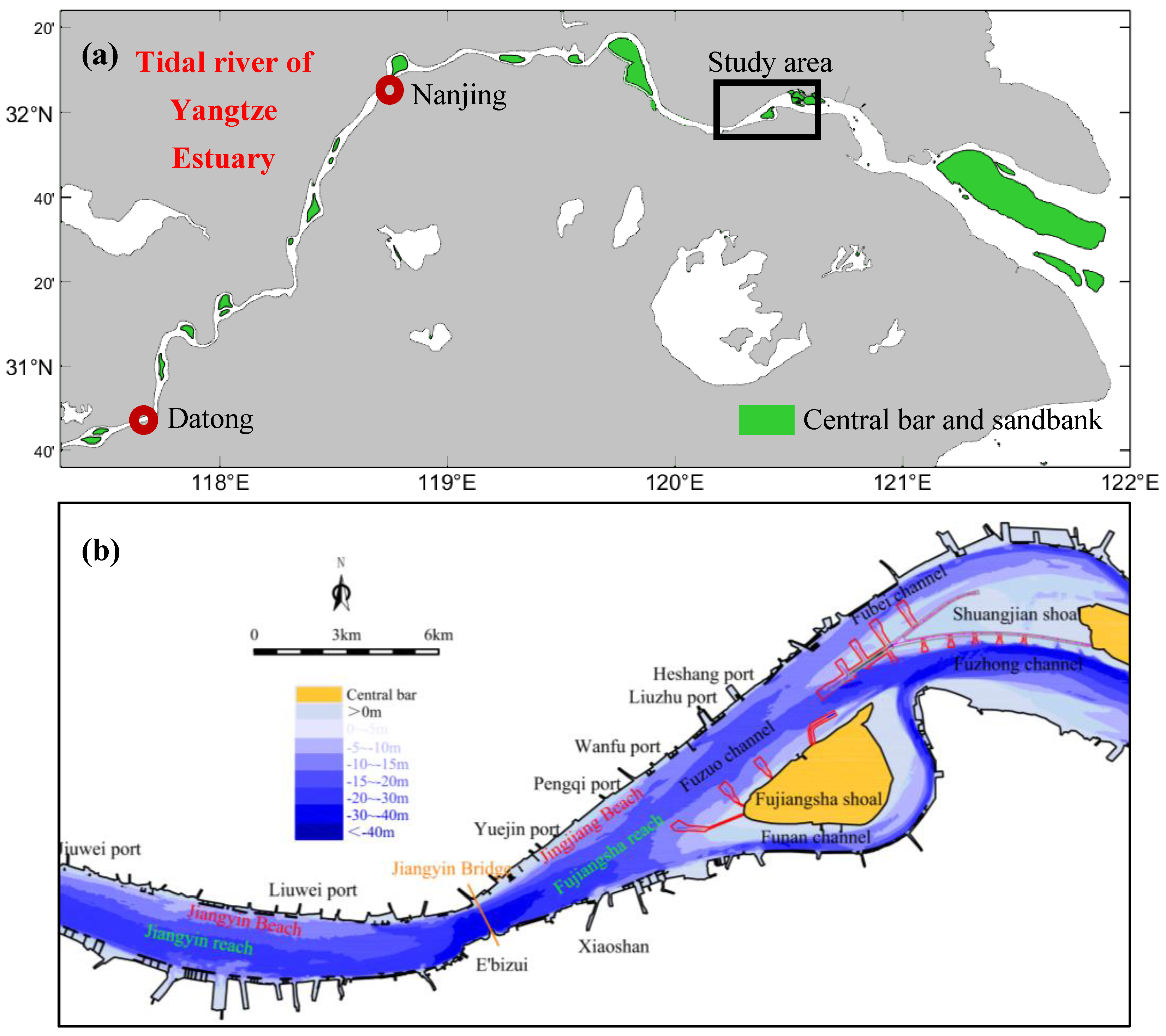
The Yangtze Estuary is a large estuary that connects the Yangtze River and the East China Sea. The average annual volume of freshwater discharged into the sea is about 9.6 × 10¹¹ m3, with a strong seasonal variation [17,18]. The Fujiangsha reach is in the tidal current transition section [19,20,21,22] of Yangtze River, with a pattern of “two-stage branching and three-branches coexisting” in terms of plane shape, and the flow split ratio is unstable [23]. The Jingjiang Beach, Fujiangsha shoal, Shuangjiansha shoal and other marginal sandbanks are in this reach, of which the waterways in Fujiangsha shoal are divided into the left branch (Fuzuo channel) and the right branch (Funan channel), and the left branch is divided into the Fubei channel and the Fuzhong channel by the Shuangjiansha shoal (Figure 1a). From 29 June 2015 to March 2017, the second stage of the DCP was implemented, and a series of dikes were built near Fujiangsha shoal and Shuangjiansha shoal (Figure 1b).
Jingjiang Beach is located on the left bank of Fujiangsha reach, as shown in Figure 1b, with numerous ports around it. According to the locations of these ports, Jingjiang Beach can be divided into three sections [6]. The Jiangyin Bridge to the Yuejin port is the upper section, with a length of 3.2 km; the Yuejin port to the Pengqi port is the middle section, with a length of 3.1 km; and the Pengqi port to the Heshang port is the lower section, with a length of 6.6 km.
2.2. Data Collection
The present study collected data on the sediment transport and flow discharge of Datong Hydrological Station from 1955 to 2019, and analyzed the incoming flow and sediment discharge of the studied area. Datong Hydrological Station (Figure 1a), located at the tidal limit of Yangtze River, is an important node station for the discharge and sediment flux of the Yangtze River into the sea. Topographic data and navigation maps of Jiangyin reach and Fujiangsha reach from 1960 to 2019 were collected to analyze the erosion and deposition changes in the riverbed, and the evolution process of Jingjiang Beach. In addition, the area, volume, and geometry parameters of Jingjiang Beach were extracted. All these data were obtained from the Changjiang Waterway Bureau, the Nanjing Hydraulic Research Institute and the Hydrological Bureau of Changjiang Water Resources Commission. The resolution and measurement instruments of the data used in this study are described in detail in Table 1.
2.3. Upstream Flow and Sediment Conditions
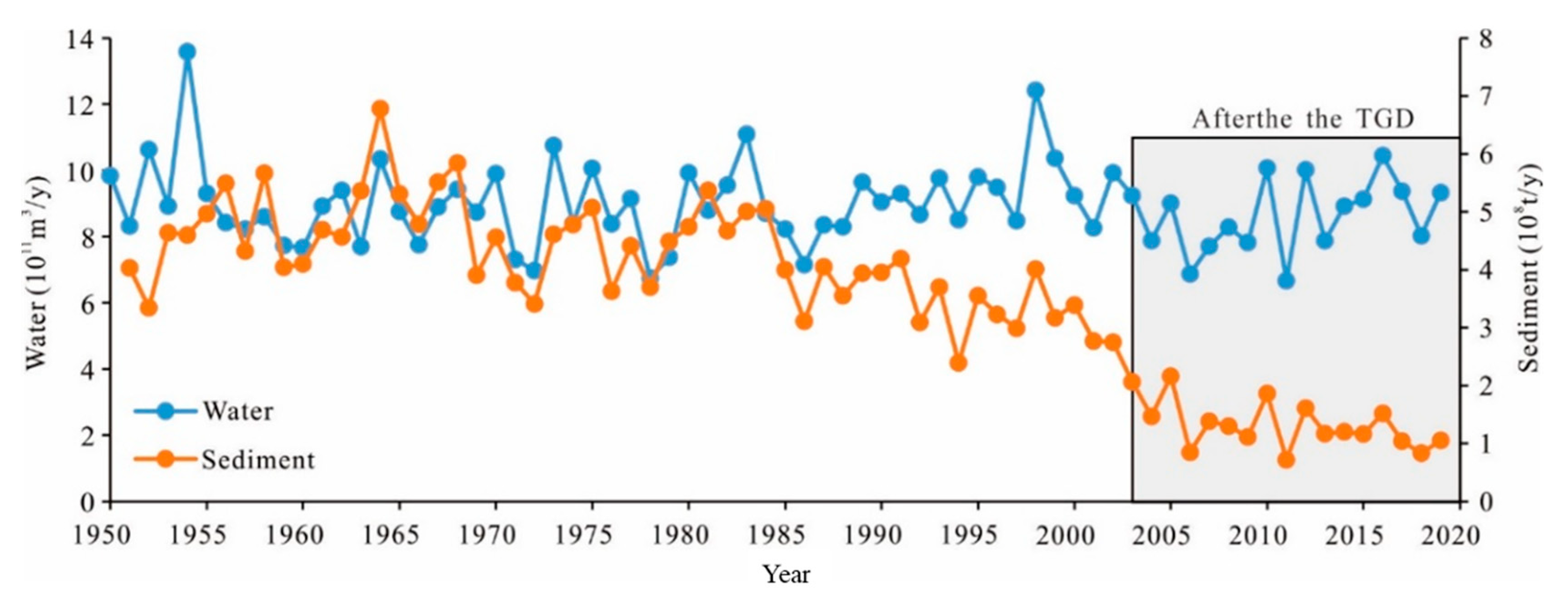
Since there is no large tributary inflow in the reach from Datong Hydrological Station to the study area, its runoff represents the incoming flow and sediment discharge of the study area (Figure 2). Since the beginning of the operation of the Three Gorges Dam (TGD) in 2003, the sediment discharge of Datong station has changed greatly. The average annual flow discharge from 2003 to 2019 decreased slightly by 4.57% compared with that from 1950 to 2002. The sediment discharge has shown a significant declining trend since the 1980s. From 2003 to 2019, it decreased by 68.9% compared with the average value from 1951 to 2002.
3. Results
3.1. Evolution Features of Jingjiang Beach
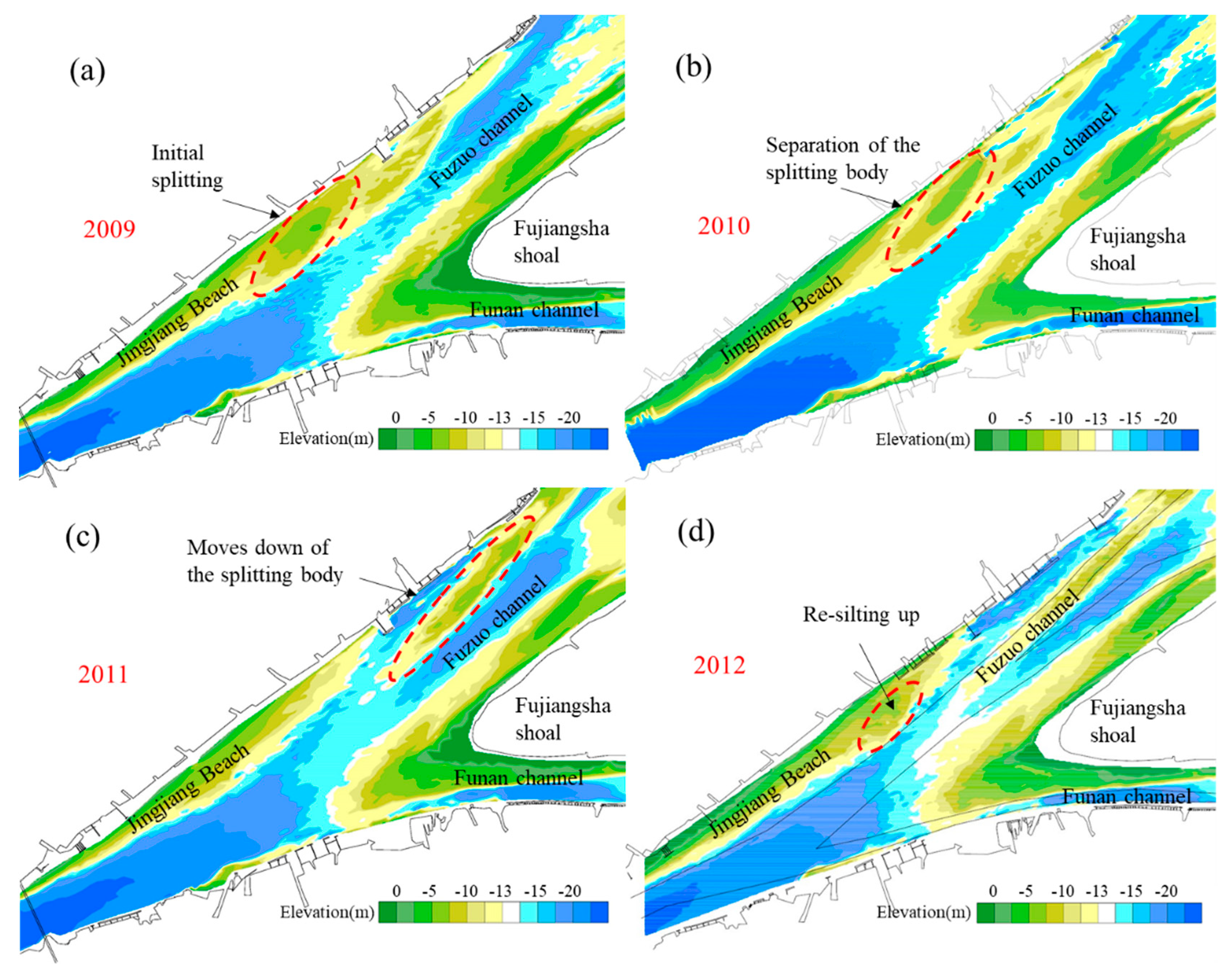
On the long-term scale, the evolution of Jingjiang Beach shows significant periodicity, mainly manifested by “silting up ~ splitting ~ re-silting up”. As an example, Figure 3 shows a complete cycle of Jingjiang Beach’s evolution from 2009 to 2012. All the splitting events in Jingjiang Beach since 1966 have been counted, as shown in Table 2, in which all splitting positions were located in the lower section of Jingjiang Beach. The direct factor controlling the splitting position of Jingjiang Beach is flow dynamic. After the water flows through the E’bizui node, the dynamic axis of flow is slightly northward and close to the middle and lower section of the Jingjiang Beach, resulting in the middle and lower sections becoming vulnerable to split. During the period from 1970 to 1999, the movement of the splitting body of Jingjiang Beach ranged from Pengqi port to Liuzhu port. Since 1999, the tail of Jingjiang Beach has been active from Wanfu port to Liuzhu port, and the maximum width of the 10 m isobath is located from Yuejin port to Wanfu port. The downward movement of the splitting body of Jingjiang Beach also has a significant impact on the downstream area. As shown in Figure 3d, the splitting body continues to move down and enters the Funan channel, which will lead to siltation of the waterway and increase dredging pressure. This also indicates that the periodic splitting events of Jingjiang Beach under natural conditions will pose a periodic threat to the safe operation of the waterway.
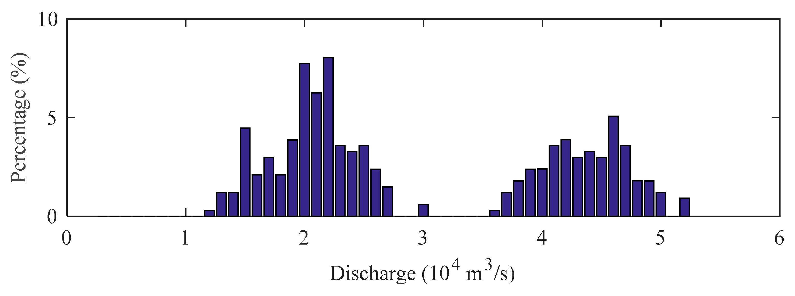
The flow discharge of the month in which all split events occur was analyzed, and the frequency diagram is shown in Figure 4. It was found that all split events occurred under relatively large (38,700~54,100 m3/s) or relatively small (11,800~23,700 m3/s) flow discharges. This implies that the split of Jingjiang Beach is significantly related to the upstream flow conditions. The statistical results (Table 2) show that the Jingjiang Beach may be split in both flood season (seven times) and dry season (six times), and most of the flow discharge at the time of splitting was >50,000 m3/s or <15,000 m3/s. Moreover, it can be noted that the maximum width of the 10 m isobath of Jingjiang Beach is generally relatively large when splitting occurs, and the statistical results show that a maximum width greater than a certain value may be an important factor in inducing splitting.
3.2. Variation of 10 m Isobath below the Water
In January 1999, the 10 m isobath below the water of Jingjiang Beach was relatively complete, with a maximum width of 1949 m and a distance of 6770 m from E’bizui (Figure 5). In 2002, the tail of Jingjiang Beach showed a splitting trend, forming a splitting body of 1.12 km2.The bathymetric map in August 2004 shows that the splitting body gradually moved down in October 2002, and its area decreased to 0.25 km2. In 2009, the shape of Jingjiang Beach was relatively complete (Figure 5), with a maximum width of 1190 m and a distance of 6200 m from E’bizui. Compared with the bathymetric map in October 2009, the tail of Jingjiang Beach was split in August 2010, forming a splitting body of 1.67 km2. By December 2012, the splitting body had gradually moved down and merged with the downstream shoal.
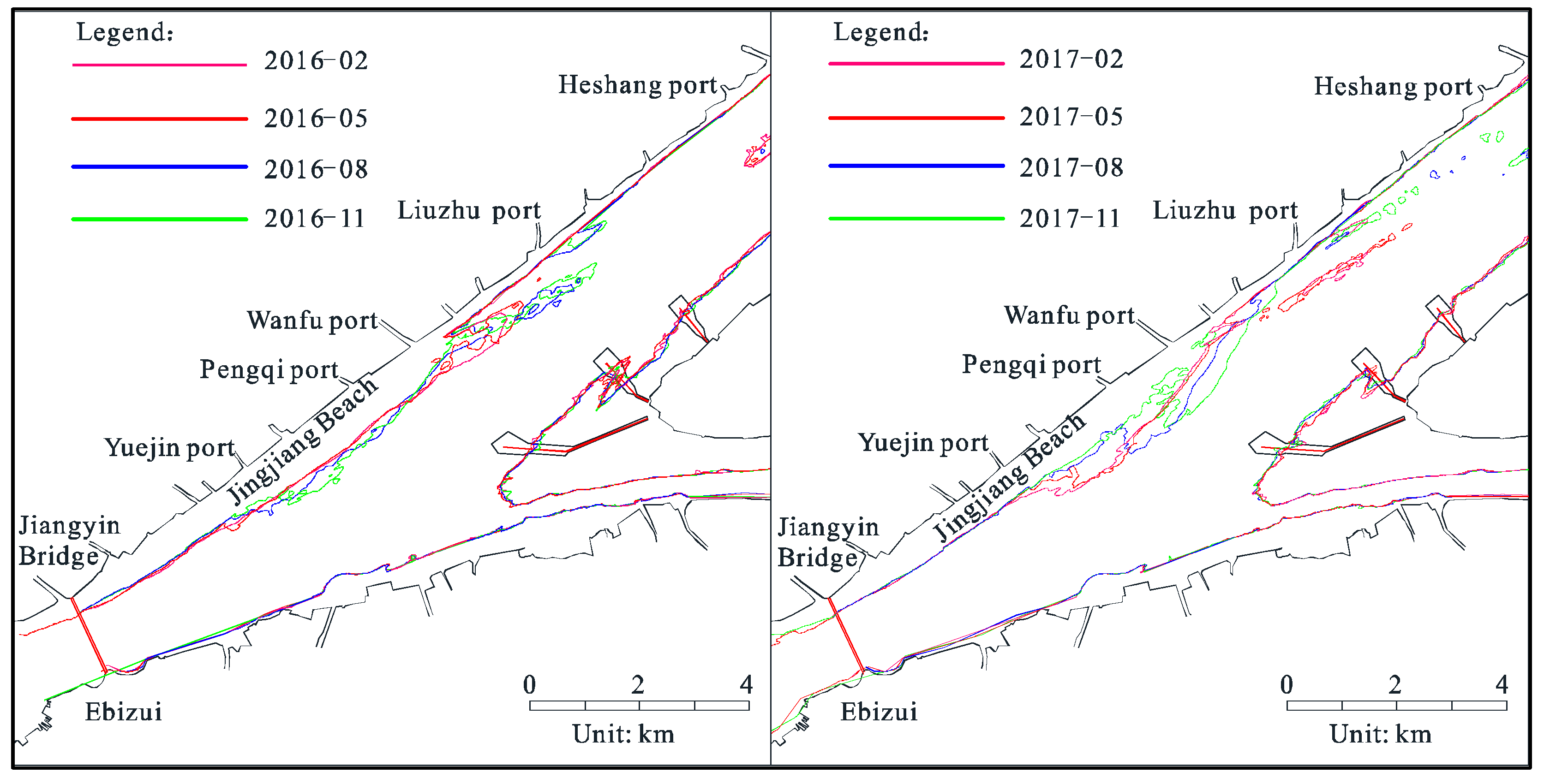
In June 2015, the construction of the Fujiangsha reach in the second stage of the DCP began, which had an impact on the local evolution of Jingjiang Beach. From February to May 2016, the 10 m isobath below the water in the middle and upper sections of Jingjiang Beach was relatively stable (Figure 6), and the tail showed a silting trend. From May to August 2016, Jingjiang Beach showed a silt-widening trend, and the tail was split, with a splitting body area of 0.22 km2. From August to November 2016, the middle section of Jingjiang Beach was scoured in the head and silted in the tail, and the silted body at the tail continued to move downstream. From February to May 2017, the middle section of Jingjiang Beach scoured in the head and silted in the tail, and the splitting body at the tail continued to move downstream, with an area of 0.17 km2 (Figure 6). From May to August 2017, the area of the split body at the tail was only 0.04 km2, indicating that the split body had already entered the Fubei channel and was transported downstream. From August to November 2017, Jingjiang Beach was scoured by the middle section and silted at the tail, and scattered sand bodies with a water depth of less than 10 m appeared in the inlet area from the Fuzuo channel to the Fubei channel.
3.3. Variation in Jingjiang Beach Sand Body Volume
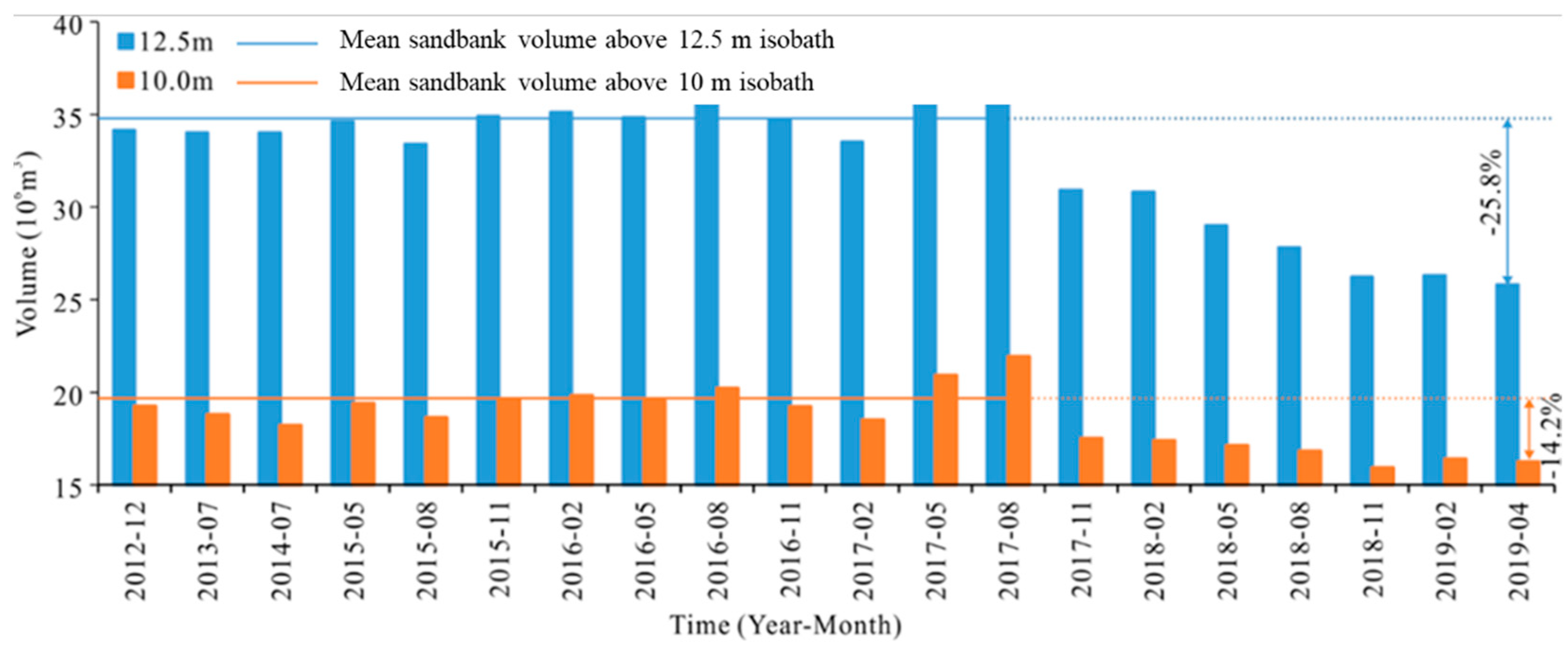
Before August 2017, the sandbank volumes above the 10 m and 12.5 m isobaths (Figure 7) showed fluctuating characteristics; the average measured volumes were 34.72 × 10⁶ m3 and 28.12 × 10⁶ m3, respectively, and the value in the flood season was higher than that in the dry season. After August 2017, the sandbank volumes above 12.5 m and 10 m showed decreasing trends. By April 2019, the volumes above 12.5 m and 10 m had decreased by about 25.8% and 14.2%, respectively, compared with the average values, which ranged from 2012 to 2017. From the perspective of volume variation, the volume of Jingjiang Beach has been decreasing since the second stage of the DCP; that is, the evolution of Jingjiang Beach has gradually become controlled by channel regulation structures.
4. Discussion
4.1. Splitting Dynamic and Geometric Characteristics of Splitting Body
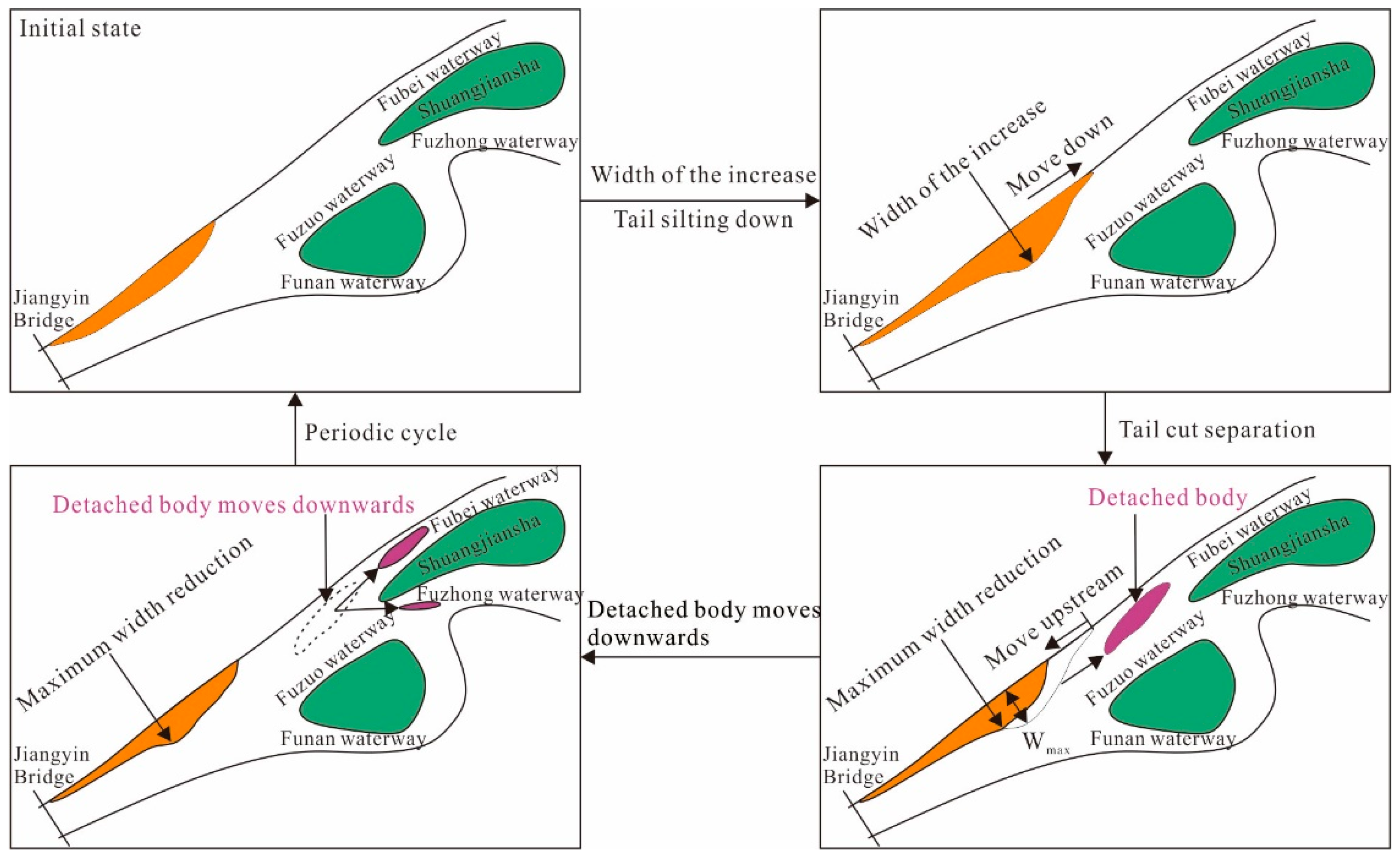
The evolution process of Jingjiang Beach can be generalized as periodic change. In the first stage, the siltation of Jingjiang Beach plays a predominant role. Specifically, the maximum width increases and the tail siltation extends downstream. In the second stage, after the maximum width of Jingjiang Beach reaches a critical state, the middle and lower sections of the beach are drastically scoured, with separated sand bodies appearing. In the third stage, the separated sand bodies are gradually scoured down into Fubei channel and Fuzhong channel, and the whole periodic evolution process is completed. Although Jingjiang Beach is located in the tidal current transition reach of the Yangtze River, its morphological evolution is still dominated by runoff [7]. Its periodic change is similar to that of the runoff reach, and is related to the flow process and the duration of characteristic flow level [24,25]. Therefore, the periodic splitting of Jingjiang Beach could be caused by its encountering a sufficiently strong runoff dynamic process, and the increased intensity caused by meeting critical morphological characteristics.
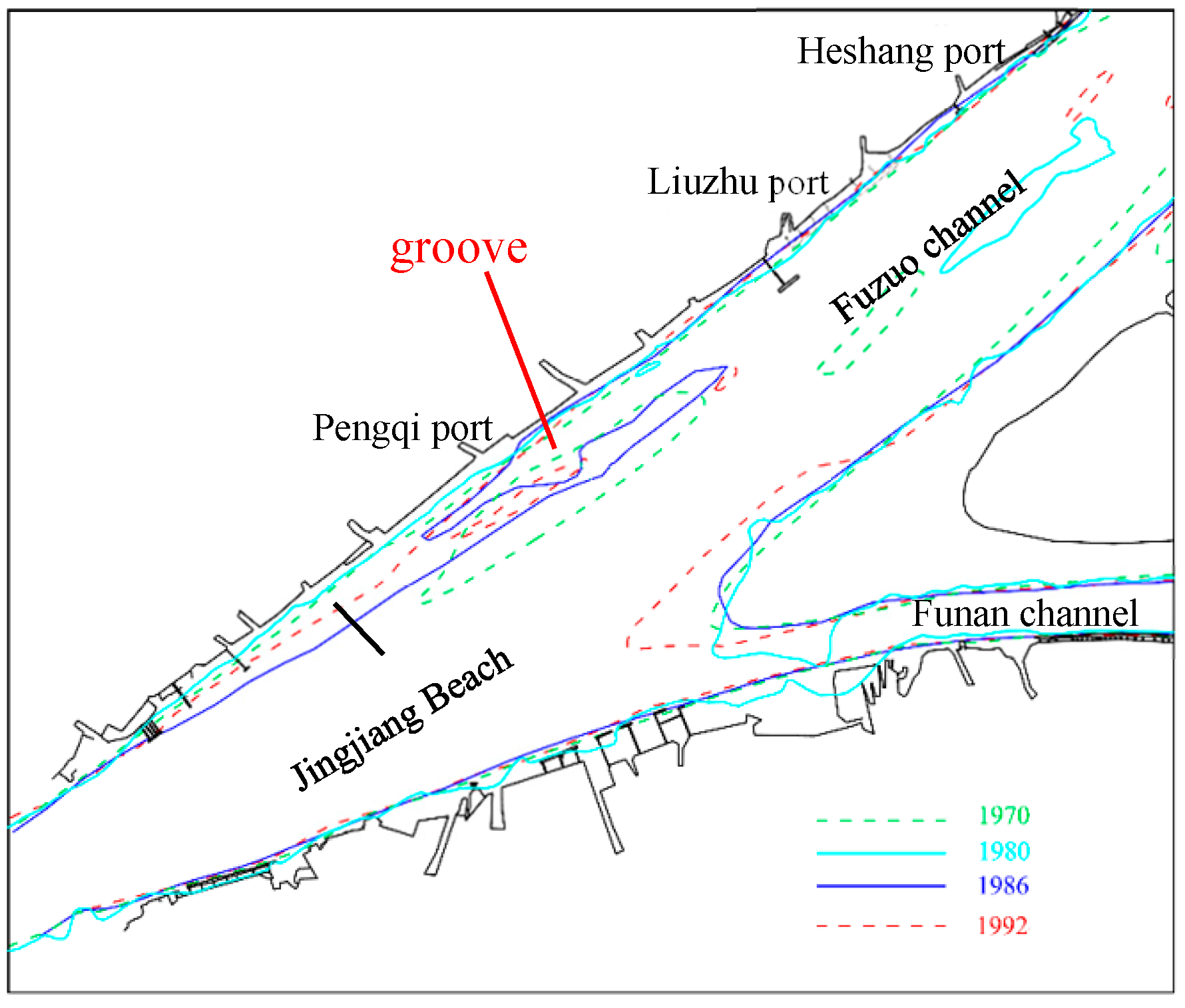
From 1950 to 2019, 13 splitting processes occurred at the tail of Jingjiang Beach, with a cycle length of 2–7 years and a concentration of 72.7% in 4–6 years (Table 2). In flood years (1970, 1975, 1980, 1989, 1998, 2010 and 2016), when the 10 m isobath width of Jingjiang Beach was greater than 1000 m, the tail was split. In these splitting events, the ebb tidal current of the superimposed flood was the direct driving force. This was dynamic enough to cause the separation of the tail of Jingjiang Beach when meeting the critical morphological conditions. In the medium-dry years (1966, 1987, 1994, 2000, 2004 and 2018), the runoff superimposed ebb tidal current theoretically failed to reach the critical condition, which would cause the separation of the tail of Jingjiang Beach. However, a groove related to the action of the flood tidal current could have appeared at the nearshore side of the tail of Jingjiang Beach in the medium-dry years. This would lead to a significant reduction in the critical condition for splitting, making it possible to split at an ebb tidal current in the dry season. Figure 8 shows the planar shape of these grooves related to the flood tidal current.
Comprehensive analysis shows that the tail splitting of Jingjiang Beach could occur in both the flood season and the dry season. In addition to the differences in the initial development process, the evolution feature of the two splitting processes is generally consistent, which is summarized in Figure 9. When the maximum width of the 10 m isobath of Jingjiang Beach is greater than 1000 m, and the number of days in the flood season of a year with a flow of more than 50,000 m3/s is relatively high (greater than the mean value), the splitting form would be primarily the separation of middle and lower sandbank bodies. If the number of days in years with moderate and small rainfall with a flow of less than 15,000 m3/s is relatively large, the flood tide hydrodynamic force would be significantly enhanced, a groove would occur at the tail and nearshore side of the Jingjiang Beach, and the ebb tidal current would flow through the middle of the siltation body between the groove and the deep trough, so that a transverse splitting trend would come into being gradually.
4.2. The Longitudinal Transport Mode of the Splitting Body
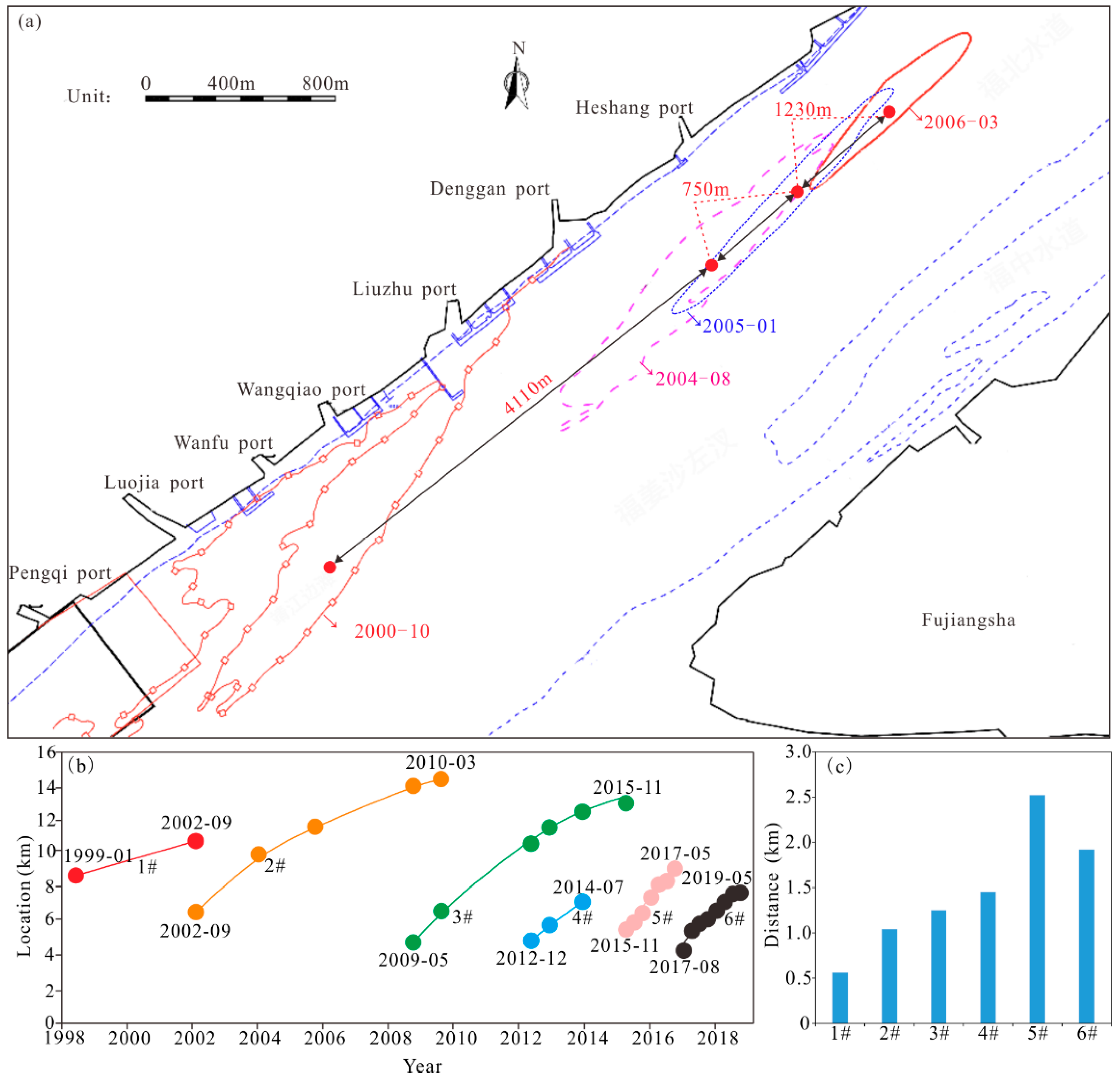
Based on the measured topography from 1998 to 2019, the center position of the splitting body (10 m isobath) of Jingjiang Beach has been identified, as shown by the red spots in Figure 10a. The analysis shows that from 1998 to 2019, the tail of Jingjiang beach underwent six relatively complete cutting processes, with a splitting cycle period of 2–7 years (Figure 10b). The initial splitting position was below 5.0 km downstream of the Jiangyin Yangtze River Bridge. In each splitting period, the longitudinal transportation distance of the splitting body was different, the maximum downward movement distance was 7.81 km (from September 2002 to March 2010, with an average annual downward movement distance of 1040 m/a), and the minimum downward distance was 3.34 km (from November 2017 to May 2019, with an average annual downward distance of 1950 m/a).
In terms of the relationship between the splitting cycle length of Jingjiang Beach and the downward movement distance of the splitting body from 1998 to 2019, the splitting periodic length of Jingjiang Beach showed a shortening trend from the second stage of DCP, and the distance from splitting body moving down to ultimately disappear was significantly shortened (Figure 10c). Overall, since the commencement of the second stage of the DCP, splitting events have become more frequent, and the distance from the splitting body moving down to disappear has shortened, which tends to weaken the impact on the downstream waterway conditions.
4.3. Morphodynamic Evolution of Upstream Jiangyin Reach
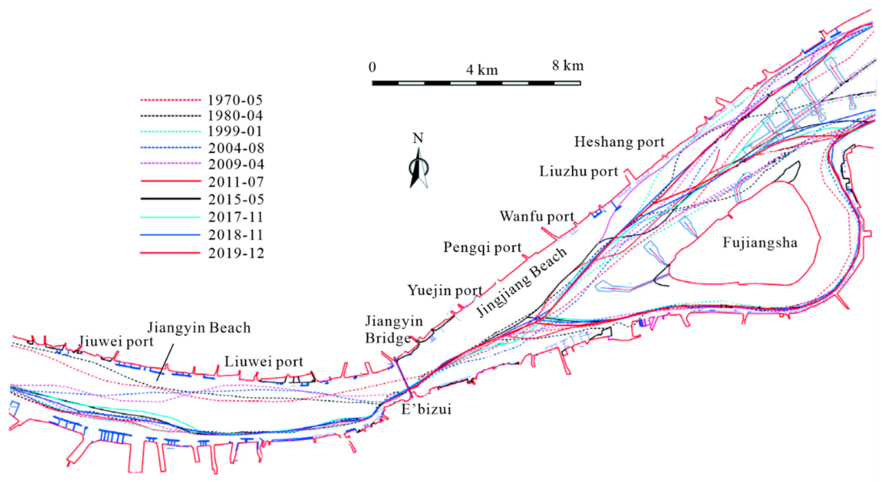
The upstream area of Fujiangsha reach is Jiangyin reach, with Jiangyin Beach situated on its left bank, which directly affects the evolution of the channel–shoal pattern of the Jiangyin bend and its linkage with the downstream Jingjiang Beach. Jiangyin Beach is located in the reach from Jiuwei port to Liuwei port (about 10 km long), and similar splitting events to those in Jingjiang Beach have also occurred here in certain years (such as 1980). In terms of the evolving relationship between the upstream and downstream channels, the node (E’bizui) from the outlet of Jiangyin reach to the inlet of Fujiangsha reach played a strong restrictive role in the transmission of hydrodynamic forces between the upstream and downstream [26]. From 1999 to 2019, no matter how the deep trough of Jiangyin channel was adjusted, the deep trough at the inlet of the Fujiangsha reach was always located in the right central area of the channel, as shown in Figure 11.
In terms of the sediment transport relationship between the Jiangyin reach and the Fujiangsha reach, the sediment scoured from the deep trough and the marginal sandbanks of Jiangyin reach was transported downstream along the channel and nearshore. In 1999, the scale of Jiangyin Beach was relatively large. With the splitting of the middle and lower sections of Jiangyin Beach, the scale of Jingjiang Beach was expanded during this period. This implies that the sediment transport from upstream plays a role in the development of Jingjiang Beach.
Since 2011, against the background of the severe decline in sediment discharge by Datong hydrological station, the scale of Jiangyin Beach has decreased, its sediment storage role has weakened, and no splitting event has occurred in the middle and lower sections. At the same time, the lower section of Jingjiang Beach still splits in the flood year. Overall, with the decrease in sediment storage in Jiangyin Beach, the sediment supply to Jingjiang Beach in flood years is showing a decreasing trend, which has reduced Jingjiang Beach’s re-siltation tendencies.
4.4. Flow and Sediment Discharge Variation for Fujiangsha Reach
The shallower part of Jingjiang Beach is concentrated in the middle and lower sections. The ebb tidal current near the sandbank area is the main driving force shaping the riverbed, but the influence of the flood tidal current cannot be ignored. There are different patterns and different splitting periods in Jingjiang Beach.
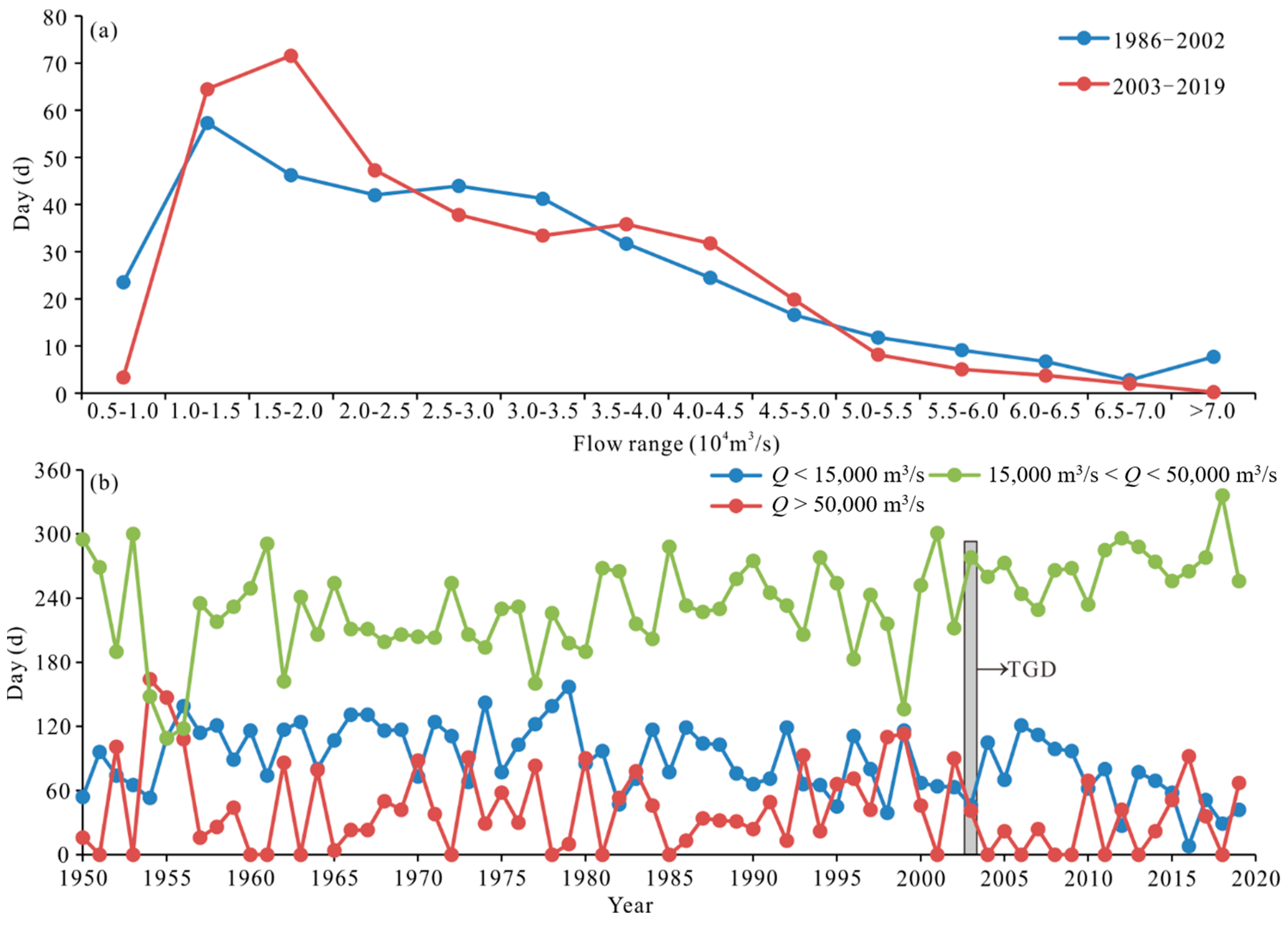
When the upstream discharge is greater than 50,000 m3/s or less than 15,000 m3/s, the tail of Jingjiang Beach is easy to split. During 1986~2002 and 2003~2019 (17 years in both periods), the numbers of days with Q > 50,000 m3/s at Datong station were 648 and 327, respectively. Compared with before the beginning of the operation of the TGD (1986~2002), the number of days per year with a flow of Q > 50,000 m3/s at Datong station from 2003 to 2019 decreased by 50.4% (Figure 12a). However, there was no significant variation in the number of days with Q > 50,000 m3/s at Datong station from 2003 to 2019. This indicates that the splitting mode of Jingjiang Beach in flood season will continue, but the splitting intensity in flood season has slowed down compared to before 2003.
From 2003 to 2019, the number of days with a flow of Q < 15,000 m3 s at Datong station also showed a decreasing trend (Figure 12b). In particular, the average annual number of days from 2009 to 2019 was 55 days—far fewer than the 95 days from 1950 to 2002; that is, the splitting intensity of Jingjiang Beach was weakened in medium-dry years.
4.5. Stability Analysis of Jingjiang Beach Based on Long-Term Evolution of Section Elevation
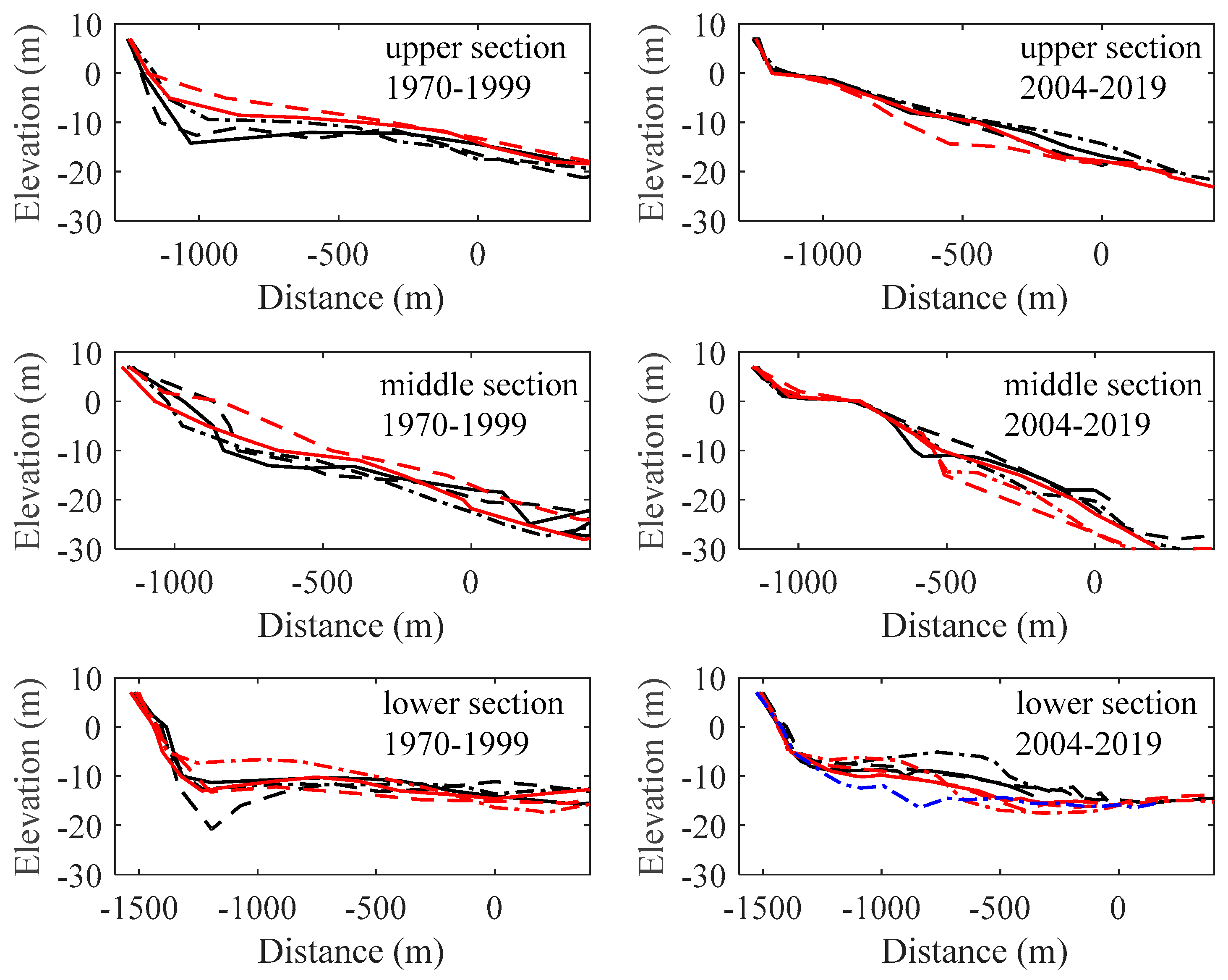
Figure 13 shows the section elevation changes in the upper, middle and lower sections of Jingjiang Beach since 1970, which is divided into two parts (1970~1999 and 2004~2019) by the commencement of TGD operation in 2003. In terms of the elevation changes from 1970 to 1999, Jingjiang Beach is characterized by instability. For decades, the section elevation below 0 m greatly fluctuated.
From 2004 to 2019, the elevation of the upper section of Jingjiang Beach changed little against the background of the significant reduction in upstream sediment inflow, and the stability of the upper section of Jingjiang Beach was enhanced. In the nearshore sideof the middle section of Jingjiang Beach, the elevation hardly changed from 2004 to 2019, while the elevation of the offshore side varied frequently. The elevation changes in the lower section of Jingjiang Beach showed similar characteristics to those before the operation of the TGD. Overall, the upper section and nearshore side of the middle section of Jingjiang Beach tend to be stable, but the rest will still be affected by periodic evolution.
In terms of the geometric characteristics of Jingjiang Beach, the incoming flow and sediment, the morphodynamic evolution of the upstream Jiangyin channel, and the long-term evolution of the section elevation of Jingjiang Beach, the split scale of Jingjiang Beach has been under control since the second stage of DCP, but attention should still be paid to the evolution process of Jingjiang Beach in flood years.
5. Conclusions
- (1)
- The initial splitting conditions of Jingjiang Beach between flood season and dry season are different. When the maximum width of the 10 m isobath of Jingjiang Beach is greater than 1000 m, and the number of days in the flood season with a flow of more than 50,000 m3/s is relatively high, the splitting form will mainly be the separation of the middle and lower beach bodies. In years with moderate or low rainfall, if the number of days with a flow less than 15,000 m3/s is high, the flood tidal current will be significantly enhanced, and a groove will occur on the tail and nearshore side of Jingjiang Beach, which will promote the occurrence of splitting caused by the ebb tidal current in dry seasons.
- (2)
- The periodic length of the splitting of Jingjiang Beach is generally 2–7 years, and the proportion of concentration in 4–6 years is 72.7%. After 2016, the sandbank body volume above the 10.0 m and 12.5 m isobaths of Jingjiang Beach decreased, and the distance for the tail splitting body from downward movement to disappear shortened. The development scale of Jingjiang Beach has decreased since the second stage of the DCP commenced.
- (3)
- Since the beginning of the operation of the TGD, the upper section and nearshore side of the middle section of Jingjiang Beach have tended to be stable, while the morphology of the offshore side of the middle section and the lower section will still be affected by periodic evolution processes.
- (4)
- With the continuous operation of the TGD, the number of days with a flow discharge less than 15,000 m3/s at Datong station is showing a decreasing trend, and the splitting scale of Jingjiang Beach may thus be reduced.
Author Contributions
Conceptualization, Y.W.; data curation, Y.W.; funding acquisition, Y.W. and Y.X.; methodology, Y.W.; resources, Y.W. and H.X.; supervision, Y.X.; validation, D.D. and H.X.; visualization, Z.C.; writing—original draft, Y.W.; writing—review and editing, F.Z. and Z.C. All authors have read and agreed to the published version of the manuscript.
Funding
This research was funded by the National Key R&D Program of China (2021YFB2600200), the Jiangsu Water Conservancy Science and Technology Project (2020002, 2020010), the Follow up Work Item of the Three Gorges Project (126302001000200002), the Young Fund Project of Nanjing Hydraulic Research Institute (Y221003) and Jiangsu Innovative and Entrepreneurship Talent Program (JSSCBS20211326).
Institutional Review Board Statement
Not applicable.
Informed Consent Statement
Not applicable.
Data Availability Statement
The data presented in this study are available from the responding author upon request.
Acknowledgments
We would like to thank the Construction Headquarters of the Deepwater Channel Project of the Yangtze River for providing the bathymetric dataset and other technical support.
Conflicts of Interest
The authors declare no conflict of interest.
References
- Huo, M.; Fan, D.; Lu, Q.; Liu, A. Decadal variations in the erosion/deposition pattern of Nanhui muddy bank and their mechanism in the Changjiang Delta. Acta Oceanol. Sin. 2010, 32, 41–51. (In Chinese) [Google Scholar]
- O’Brien, D.J.; Whitehouse, R.J.S.; Cramp, A. The cyclic development of a macrotidal mudflat on varying timescales. Cont. Shelf Res. 2000, 20, 1593–1619. [Google Scholar] [CrossRef]
- Augustinus, P. The influence of the trade winds on the coastal development of the Guianas at various scale levels: A synthesis. Mar. Geol. 2004, 208, 145–151. [Google Scholar] [CrossRef] [Green Version]
- Billy, J.; Chaumillon, E.; Féniès, H.; Poirier, C. Tidal and fluvial controls on the morphological evolution of a lobate estuarine tidal bar: The Plassac Tidal Bar in the Gironde Estuary (France). Geomorphology 2012, 169–170, 86–97. [Google Scholar] [CrossRef]
- Du, D.; Wang, X.; Xia, Y.; Wen, Y. Hydrodynamic characteristics of Jingjiang beach evolution. Port Waterw. Eng. 2021, 581, 75–80. (In Chinese) [Google Scholar]
- Du, D.; Wen, Y.; Wang, X.; Xia, Y.; Chen, J. Sectional evolution characteristics and regulation of Jingjiang beach in Fujiangsha reach of the Yangtze River. Yangtze River 2021, 52, 1–6. (In Chinese) [Google Scholar]
- Hu, Y.; Cao, M.; Ma, A.; Dou, X.; Wen, Y. An analysis of the periodic evolution of the Jingjiang Sandbank in the tidal reach of the Yangtze River. Water 2020, 12, 1652. [Google Scholar] [CrossRef]
- Dam, G.; van der Wegen, M.; Labeur, R.J.; Roelvink, D. Modeling centuries of estuarine morphodynamics in the Western Scheldt estuary. Geophys. Res. Lett. 2016, 43, 3839–3847. [Google Scholar] [CrossRef] [Green Version]
- Shen, Q.; Wang, W.; Gu, F. Fluvial processes of the point bar at the transition area between meander Jiangying reach and bifurcated Fujiang shoal reach. J. Sediment Res. 2020, 4, 23–30. (In Chinese) [Google Scholar]
- Yang, Y.; Zheng, J.; Zhang, M.; Zhu, L.; Zhu, Y.; Wang, J.; Zhao, W. Sandy riverbed shoal under anthropogenic activities: The sandy reach of the Yangtze River, China. J. Hydrol. 2021, 63, 126861. [Google Scholar] [CrossRef]
- Yang, Y.; Zhang, M.; Zhu, L.; Zhang, H.; Liu, W.; Wang, J. Impact of the operation of a large-scale reservoir on downstream river channel geomorphic adjustments: A case study of the Three Gorges. River Res. Appl. 2018, 34, 1315–1327. [Google Scholar] [CrossRef]
- Yang, Y.; Zheng, J.; Zhang, W.; Zhu, Y.; Chai, Y.; Wang, J.; Wen, Y. Quantitative relationship between channels and bars in a tidal reach of the lower Yangtze River: Implications for river management. J. Geogr. Sci. 2021, 31, 1837–1851. [Google Scholar] [CrossRef]
- Yang, Y.; Zheng, J.; Zhang, H.; Chai, Y.; Zhu, Y.; Wang, C. Impact of the Three Gorges Dam on riverbed scour and siltation of the middle reaches of the Yangtze River. Earth Surf. Proc. Land. 2022, in press. [Google Scholar] [CrossRef]
- Sun, J.; Zhang, F.; Zhang, X.; Lin, B.; Yang, Z.; Yuan, B.; Falconer, R.A. Severely Declining Suspended Sediment Concentration in the Heavily Dammed Changjiang Fluvial System. Water Resour. Res. 2021, 57, e2021WR030370. [Google Scholar] [CrossRef]
- Yang, Y.; Zhang, M.; Liu, W.; Wang, J.; Li, X. Relationship between waterway depth and low-flow water levels in reaches below the Three Gorges Dam. J. Waterw. Port Coast. Ocean Eng. 2019, 145, 04018032. [Google Scholar] [CrossRef]
- Jiao, J.; Dou, X.; Gao, X.; Ding, L.; Yang, X. Morphodynamic characteristics and medium-term simulation of the north—south passage under the impact of the Yangtze Estuary deepwater navigation channel project. China Ocean. Eng. 2020, 34, 198–209. [Google Scholar] [CrossRef]
- Zhang, F.; Lin, B.; Sun, J. Current reversals in a large tidal river. Estuar. Coast. Shelf Sci. 2021, 223, 74–81. [Google Scholar] [CrossRef]
- Zhang, F.; Sun, J.; Lin, B.; Huang, G. Seasonal hydrodynamic interactions between tidal waves and river flows in the Yangtze Estuary. J. Mar. Syst. 2018, 186, 17–28. [Google Scholar] [CrossRef]
- Yang, Y.; Li, Y.; Sun, Z.; Fan, Y. Suspended sediment load in the turbidity maximum zone at the Yangtze River Estuary: The trends and causes. J. Geogr. Sci. 2014, 24, 129–142. [Google Scholar] [CrossRef]
- Yang, Y.; Deng, J.; Zhang, M.; Li, Y.; Liu, W. The synchronicity and difference in the change of suspended sediment concentration in the Yangtze River Estuary. J. Geogr. Sci. 2015, 25, 399–416. [Google Scholar] [CrossRef]
- Fan, Y.; Li, Y.; Yang, Y.; Huang, L. Vertical velocity structure distribution in the Sansha area of the Yangtze Estuary, China. J. Mar. Sci. Technol. 2017, 22, 327–334. [Google Scholar]
- Zheng, S.; Cheng, H.; Shi, S.; Xu, W.; Zhou, Q.; Jiang, Y.; Zhou, F.; Cao, M. Impact of anthropogenic drivers on subaqueous topographical change in the Datong to Xuliujing reach of the Yangtze River. Sci. China-Earth Sci. 2018, 61, 940–950. [Google Scholar] [CrossRef]
- Chen, Y.; Li, J.; Wu, Z.; Pan, S. Dynamic analysis of riverbed evolution: Chengtong Reach of Yangtze Estuary. J. Coast. Res. 2016, 75, 203–207. [Google Scholar] [CrossRef] [Green Version]
- Han, J.; Zhang, W.; Yuan, J.; Fan, Y. Channel evolution under changing hydrological regimes in anabranching reaches downstream of the Three Gorges Dam. Front. Earth Sci. 2018, 12, 640–648. [Google Scholar] [CrossRef]
- You, X.; Zhang, X.; Wan, W.; Tang, J.; Peng, X.; Wang, S.; Rao, H.; Yang, Y. Mutability and periodicity of the characteristic flow level of bifurcated reaches in the middle reaches of the Yangtze River. J. Hydrol. Eng. 2020, 25, 05020027. [Google Scholar] [CrossRef]
- You, X.; Tang, J.; Zhang, X.; Hou, W.; Yang, Y.; Sun, Z.; Weng, Z. The mechanism of barrier river reaches in the middle and lower Yangtze River. J. Geogr. Sci. 2017, 27, 1249–1267. [Google Scholar] [CrossRef] [Green Version]
Figure 1.
(a) Tidal river of Yangtze Estuary; (b) river regime of the study area.

Figure 2.
Variation of flow and sediment discharge of the Datong Hydrological station since 1950.

Figure 3.
Evolution features of Jingjiang Beach: (a) Initial splitting stage; (b) splitting completion stage; (c) splitting body downward movement stage; (d) re-silting up stage.
Figure 3.
Evolution features of Jingjiang Beach: (a) Initial splitting stage; (b) splitting completion stage; (c) splitting body downward movement stage; (d) re-silting up stage.

Figure 4.
Frequency diagram of flow discharge statistics in the month of splitting.

Figure 5.
Evolution of the 10 m isobath of Jingjiang Beach under natural condition from 1999 to 2012.
Figure 5.
Evolution of the 10 m isobath of Jingjiang Beach under natural condition from 1999 to 2012.

Figure 6.
Evolution of the 10 m isobath of Jingjiang Beach under the effect of the second stage of the DCP from 2016 to 2017.
Figure 6.
Evolution of the 10 m isobath of Jingjiang Beach under the effect of the second stage of the DCP from 2016 to 2017.

Figure 7.
Changes in the volume of the Jingjiang Beach; the line represents the mean value of volume before August 2017.
Figure 7.
Changes in the volume of the Jingjiang Beach; the line represents the mean value of volume before August 2017.

Figure 8.
10 m isobath of the Fujiangsha reach when the grooves related to the flood tidal current appear.
Figure 8.
10 m isobath of the Fujiangsha reach when the grooves related to the flood tidal current appear.

Figure 9.
Evolution features of the Jingjiang Beach and nearby sandbanks.

Figure 10.
(a) Center position of the splitting body of Jingjiang Beach from October 2000 to March 2006. (b) Movement tracks of the splitting body, the reference point (0 km) is located at Jiangyin Bridge. (c) The longitudinal transport distance of the splitting body of Jingjiang Beach for each cycle.

Figure 11.
Deep trough changes of Jiangyin–Fujiangsha reach.

Figure 12.
Variation in characteristic flow at Datong station. (a) Characteristic flow variation; (b) number of days with characteristic discharge.
Figure 12.
Variation in characteristic flow at Datong station. (a) Characteristic flow variation; (b) number of days with characteristic discharge.

Figure 13.
Long-term evolution of section elevation of Jingjiang Beach.


Table 1.
Materials used in the study and parameter comparison.
| Content | Instruments/Methods | Measuring Density | Research Content |
|---|---|---|---|
| Flow rate | Acoustic Doppler Current Profiler (ADCP) | The transverse interval is 100 m and the longitudinal section interval is 2000–3000 m. | Calculating diversion ratio of branching channels and analyzing the hydrodynamic changes in the marginal sandbank area. |
| Sediment concentration | Filtration dry-weighing method | Weighing with 1:10,000 electronic balance | Analyzing the sediment transport process and the suspended sediment concentration of the Fujiangsha reach. |
| Topography | Differential global positioning system (DGPS) combined with echo sounder | A scale of 1:10,000 | Analyzing the scouring and silting amounts and the distributions of the rivers, and researching the relationship between the evolution of the marginal shoal and the erosion and siltation of the navigation channel. |
Table 2.
Jinjiang Beach splitting statistics since 1966.
| Number | Date | Mean Splitting Discharge (m3/s) | Splitting Position | Maximum Width of 10 m Isobath before Splitting (m) |
|---|---|---|---|---|
| 1 | November 1966 | 13,460 | Pengqi port ~ Liuzhu port | 1528 |
| 2 | June 1970 | 54,100 | Pengqi port ~ Liuzhu port | 1855 |
| 3 | March 1975 | 11,800 | Pengqi port ~ Liuzhu port | 1080 |
| 4 | March 1980 | 13,040 | Liuzhu port ~ Heshang port | 274 |
| 5 | September 1987 | 45,340 | Wanfu port | 929 |
| 6 | August 1989 | 38,690 | Pengqi port ~ Wanfu port | / |
| 7 | July 1994 | 53,000 | Pengqi port ~ Wanfu port | 1125 |
| 8 | October 1998 | 47,900 | Liuzhu port | 1452 |
| 9 | October 2000 | 40,900 | Pengqi port ~ Liuzhu port | 1949 |
| 10 | August 2004 | 39,950 | Pengqi port ~ Liuzhu port | 1797 |
| 11 | March 2010 | 15,520 | Pengqi port ~ Liuzhu port | 1190 |
| 12 | February 2016 | 18,020 | Wanfu port | 1596 |
| 13 | March 2018 | 23,700 | Pengqi port ~ Wanfu port | 1250 |
Publisher’s Note: MDPI stays neutral with regard to jurisdictional claims in published maps and institutional affiliations. |
© 2022 by the authors. Licensee MDPI, Basel, Switzerland. This article is an open access article distributed under the terms and conditions of the Creative Commons Attribution (CC BY) license (https://creativecommons.org/licenses/by/4.0/).
Share and Cite
MDPI and ACS Style
Wen, Y.; Xia, Y.; Du, D.; Xu, H.; Zhang, F.; Cheng, Z. Study of Jingjiang Beach Morphodynamics in the Tidal Reach of the Yangtze River. Water 2022, 14, 1109. https://doi.org/10.3390/w14071109
AMA Style
Wen Y, Xia Y, Du D, Xu H, Zhang F, Cheng Z. Study of Jingjiang Beach Morphodynamics in the Tidal Reach of the Yangtze River. Water. 2022; 14(7):1109. https://doi.org/10.3390/w14071109
Chicago/Turabian StyleWen, Yuncheng, Yunfeng Xia, Dejun Du, Hua Xu, Fanyi Zhang, and Zelin Cheng. 2022. "Study of Jingjiang Beach Morphodynamics in the Tidal Reach of the Yangtze River" Water 14, no. 7: 1109. https://doi.org/10.3390/w14071109
Note that from the first issue of 2016, this journal uses article numbers instead of page numbers. See further details here.