
Application of Hierarchical Clustering Endmember Modeling Analysis for Identification of Sedimentary Environment in the Houtao Section of the Upper Yellow River


Abstract
:1. Introduction
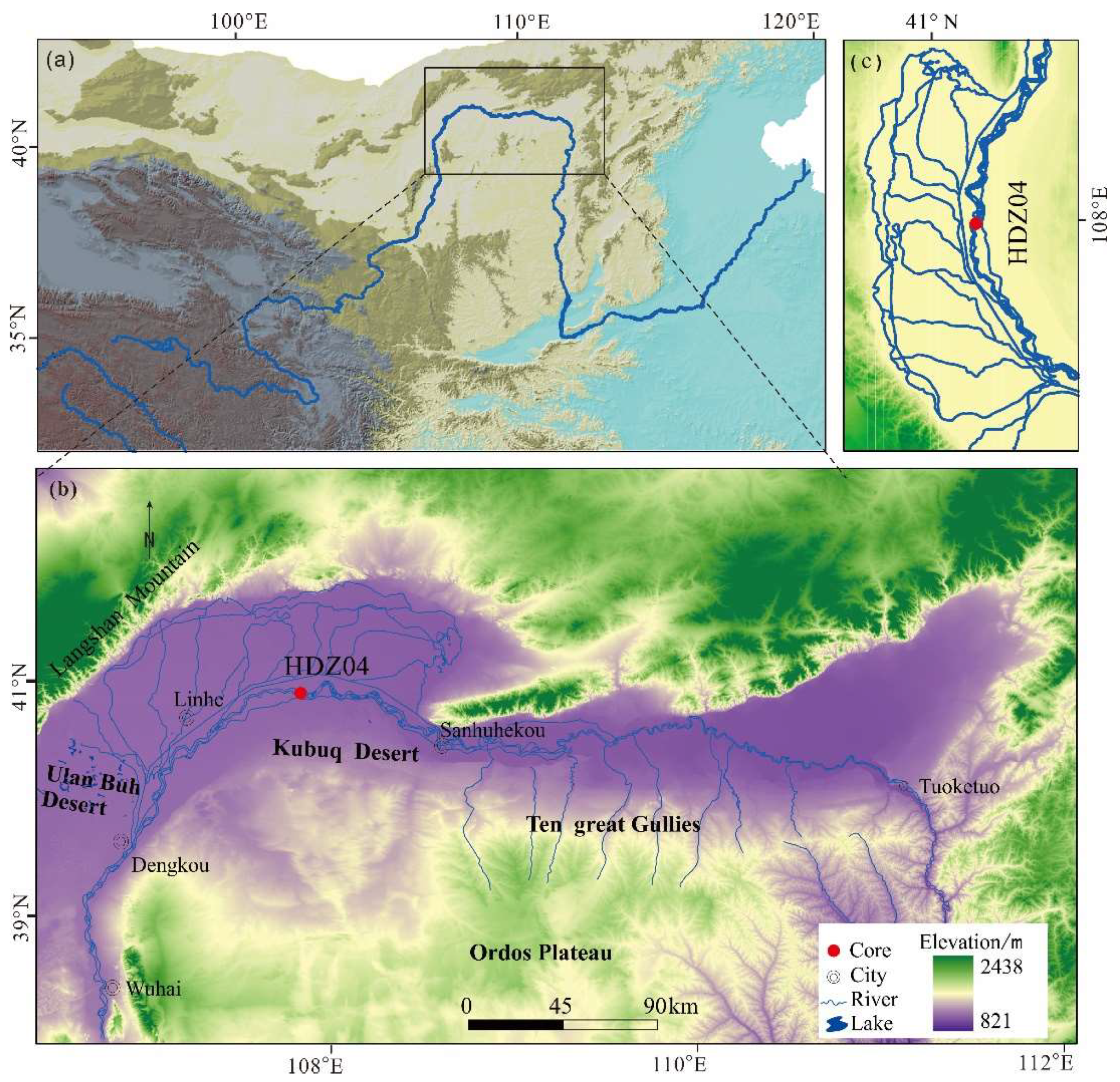
2. Study Area
3. Materials and Methods
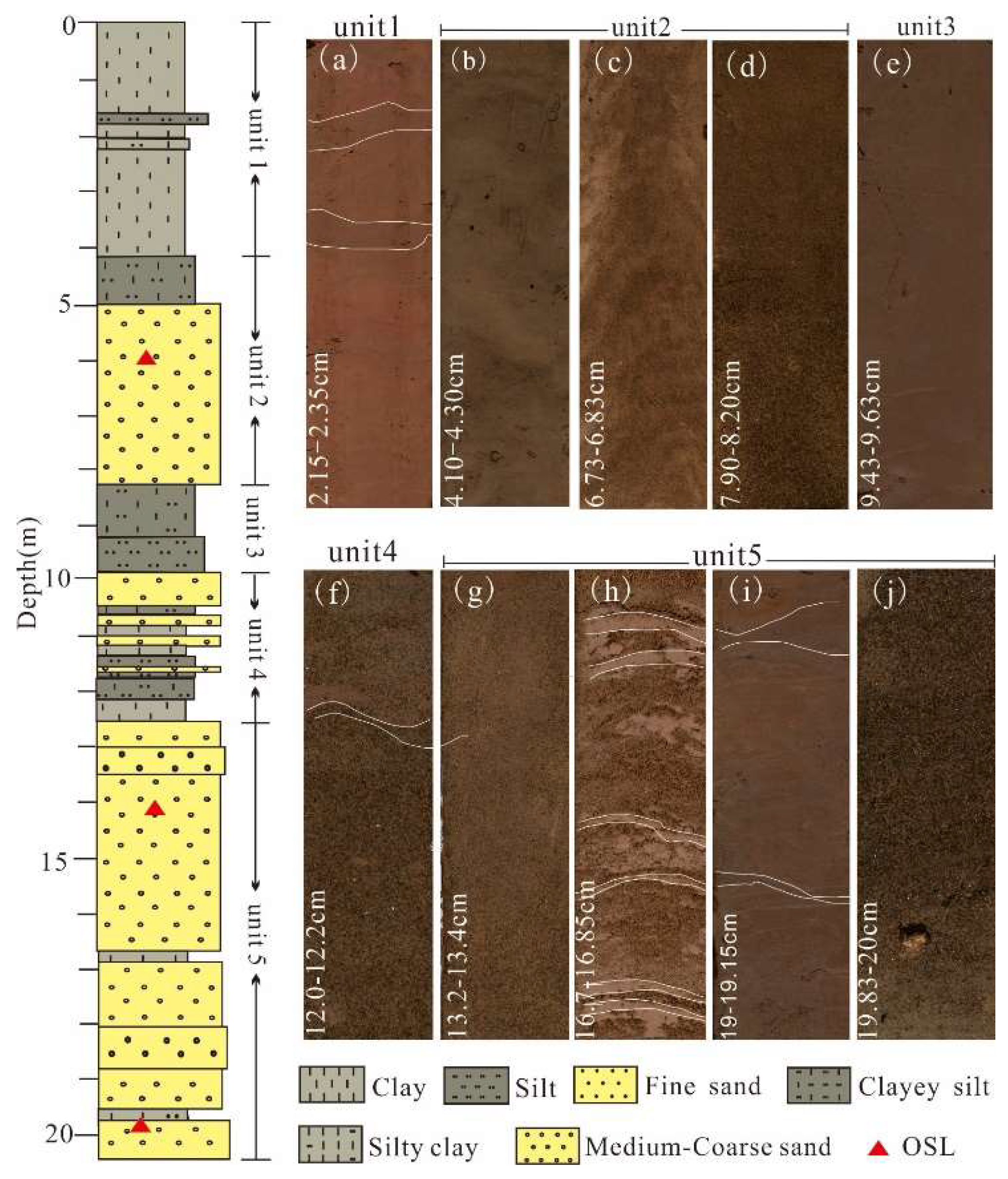
3.1. Drill and Sampling
3.2. Grain Size
3.3. OSL Age
3.4. Hierarchical Clustering End-Member Modeling Analysis (CEMMA)
4. Results
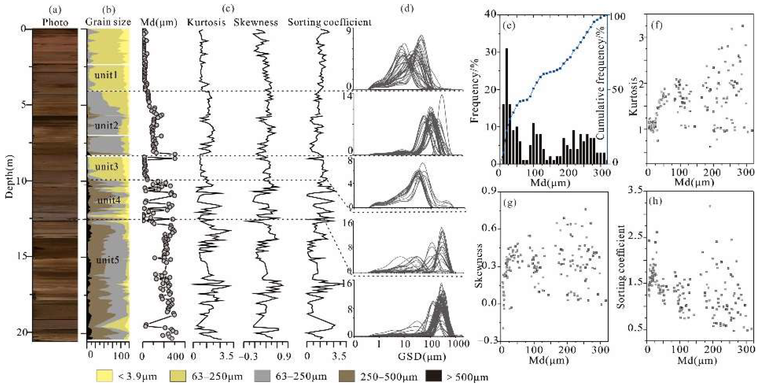
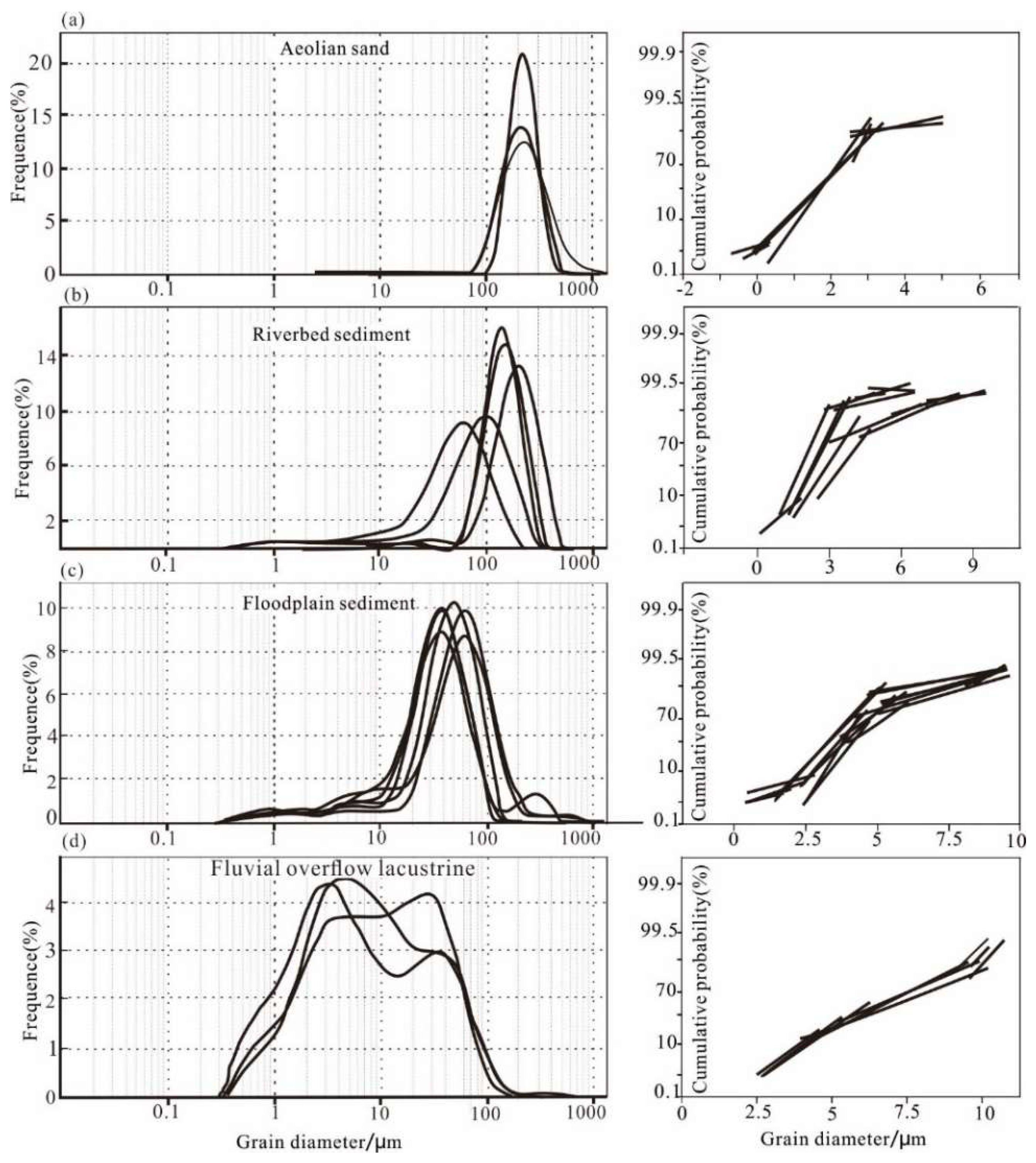
4.1. Grain-Size Characteristics of Core HDZ04
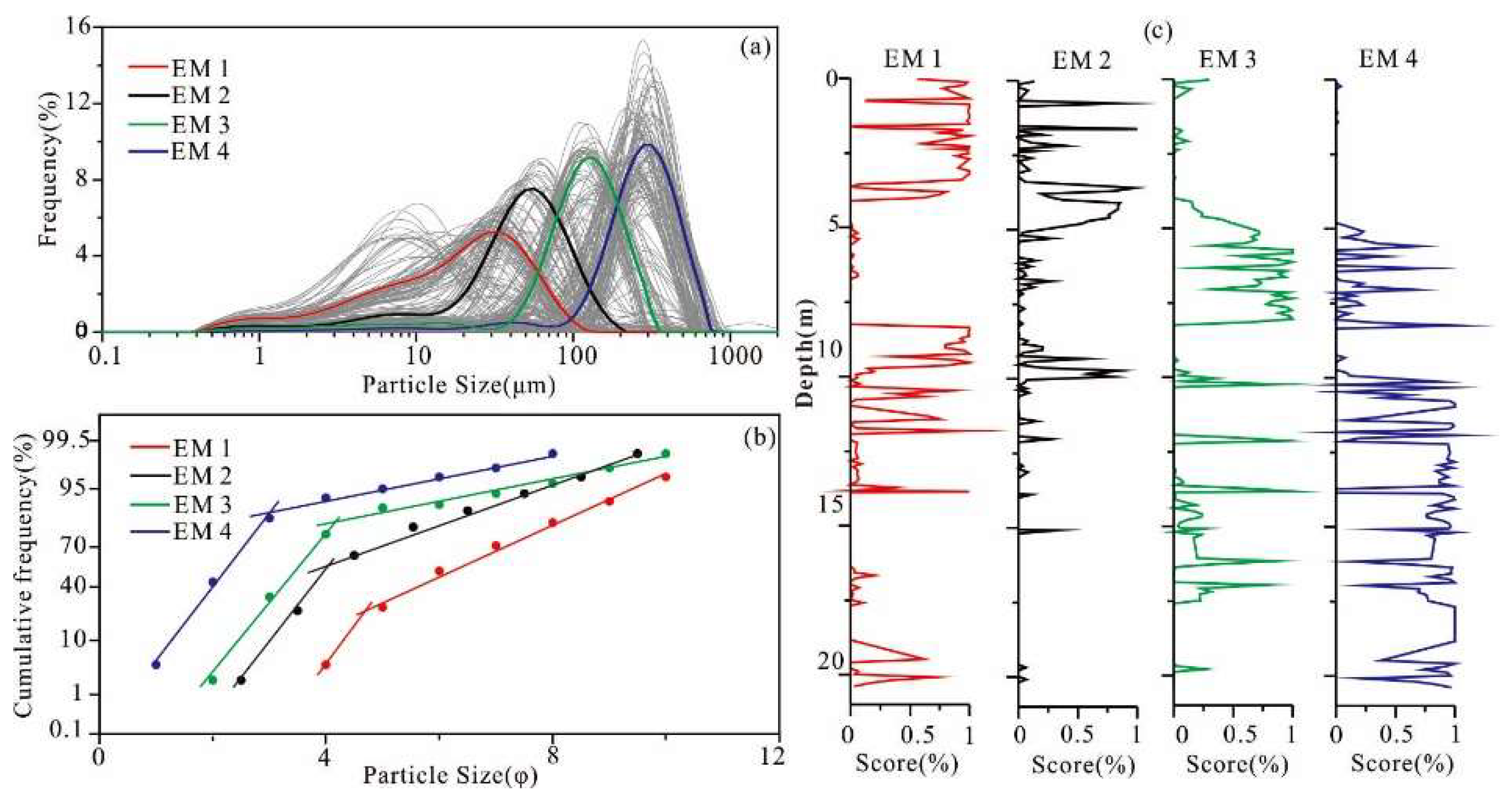
4.2. End-Member Analysis
5. Discussion
5.1. Interpretation of End Members
5.2. Reconstruction of Depositional Environment in HDZ04
5.3. Evolution of Depositional Environment
6. Conclusions
Author Contributions
Funding
Institutional Review Board Statement
Informed Consent Statement
Data Availability Statement
Acknowledgments
Conflicts of Interest
References
- Coulthard, T.J.; Macklin, M.G. How sensitive are river systems to climate and land-use changes? A model-based evaluation. J. Quat. Sci. 2001, 16, 347–351. [Google Scholar] [CrossRef]
- Apollaro, C.; Marini, L.; De Rosa, R.; Settembrino, P.; Scarciglia, F.; Vecchio, G. Geochemical features of rocks, stream sediments, and soils of the Fiume Grande Valley (Calabria, Italy). Environ. Geol. 2007, 52, 719–729. [Google Scholar] [CrossRef]
- Singh, P.; Rajamani, V. Geochemistry of the Floodplain Sediments of the Kaveri River, Southern India. J. Sediment. Res. 2001, 71, 50–60. [Google Scholar] [CrossRef]
- Radoane, M.; Radoane, N.; Dumitriu, D.; Crina Miclaus, C. Downstream variation in bed sediment size along the East Carpathian rivers: Evidence of the role of sediment sources. Earth Surf. Processes Landf. 2008, 33, 674–694. [Google Scholar] [CrossRef]
- Snelder, T.H.; Lamouroux, N.; Pella, H. Empirical modelling of large scale patterns in river bed surface grain size. Geomorphology 2011, 127, 189–197. [Google Scholar] [CrossRef]
- Walling, D.E. The evolution of sediment source fingerprinting investigations in fluvial systems. J. Soil Sediments 2013, 13, 1658–1675. [Google Scholar] [CrossRef]
- Folk, R.L.; Ward, W.C. Brazos river bar A study in the significance of grain size parameters. J. Sediment. Petrol. 1957, 27, 3–26. [Google Scholar] [CrossRef]
- Ashley, G.M. Interpretation of polymodal sediments. J. Geol. 1978, 86, 411–421. [Google Scholar] [CrossRef]
- Bagnold, R.A.; Barndorff-Nielsen, O. The pattern of natural size distributions. Sedimentology 1980, 27, 199–207. [Google Scholar] [CrossRef]
- Sahu, B.K. Depositional Mechanisms from the Size Analysis of Clastic Sediments. J. Sediment. Res. 1964, 34, 73–83. [Google Scholar]
- Sheridan, M.F.; Wohletz, K.H.; Dehn, J. Discrimination of grain size subpopulations in pyroclastic deposits. Geology 1987, 15, 367. [Google Scholar] [CrossRef]
- Shih, S.; Komar, P.D. Sediments, beach morphology and sea cliff erosion within an Oregon coast littoral cell. J. Coast. Res. 1994, 10, 144–157. [Google Scholar]
- Prins, M.A.; Vriend, M.; Nugteren, G.; Vandenberghe, J.; Lu, H.; Zheng, H.; Wetje, G.J. Late Quanternary aeolian input variability on the China Loess Plateau: Inference from unmixing of loess grain-size records. Quat. Sci. Rev. 2007, 26, 230–242. [Google Scholar] [CrossRef]
- Van Hateren, J.A.; Prins, M.A.; Balen, R.V. On the genetically meaningful decomposition of grain-size distributions: A comparison of different end-member modelling algorithms. Sediment. Geol. 2017, 375, 1–23. [Google Scholar] [CrossRef]
- Middleton, G.V. Hydraulic interpretation of sand size distributions. J. Geol. 1976, 84, 405–426. [Google Scholar] [CrossRef]
- IJmker, J.; Stauch, G.; Hartmann, K.; Diekmann, B.; Dietze, E.; Opitz, S.; Wϋnnemann, B.; Lehmkuhl, F. Environmental conditions in the Donggi Cona lake catchment, NE Tibetan Plateau, based on factor analysis of geochemical data. J. Asian Earth Sci. 2012, 44, 176–188. [Google Scholar] [CrossRef]
- Paterson, G.A.; Heslop, D. New methods for unmixing sediment grain size data. Geochem. Geophys. Geosyst. 2015, 16, 4494–4506. [Google Scholar] [CrossRef] [Green Version]
- Wejie, G.J. End-member modeling of compositional data Numerical-statistical algorithms for solving the explicit mixing problem. Math. Geol. 1997, 29, 503–549. [Google Scholar] [CrossRef]
- Dietze, E.; Hartmann, K.; Diekmann, B.; Ijmker, J.; Lehmkuhl, F.; Opitz, S.; Stauch, G.; Wϋnnemann, B.; Borchers, A. An end- member algorithm for deciphering modern detrital modern processes for lake sediments of Lake Donggi Cona, NE Tibetan Plateau, China. Sediment. Geol. 2012, 243, 169–180. [Google Scholar] [CrossRef]
- Yu, S.; Colman, S.M.; Li, L. BEMMA: A Hierarchical Bayesian End-Member Modeling Analysis of sediments grain size distributions. Math. Geosci. 2016, 48, 723–741. [Google Scholar] [CrossRef]
- Zhang, X.; Zhou, A.; Wang, X.; Song, M.; Zhao, Y.; Xie, H.C.; Russell, J.M.; Chen, F. Unmixing grain size distribution in lake sediments: A new method of end member modeling using hierarchical clustering. Quat. Res. 2018, 89, 365–373. [Google Scholar] [CrossRef]
- Andrews, J.T.; Eberl, D.D. Determination of sediment provenance by unmixing the mineralogy of source-area sediments: The “SedUnMix” program. Mar. Geol. 2012, 291–294, 24–33. [Google Scholar] [CrossRef]
- Peng, F.; Prins, M.A.; Kasse, C.; Cohen, K.M.; Van der Putten, N.; Van der Lubbe, J.; Toonen, W.; Ban, R.T. An improved method for paleoflood reconstruction and flooding phase identification, applied to the Meuse River in the Netherlands. Glob. Planet. Change 2019, 177, 213–224. [Google Scholar] [CrossRef]
- Wang, S.J.; Yan, Y.X.; Li, Y.K. Spatial and temporal variations of suspended sediment deposition in the alluvial reach of the upper Yellow River from 1952 to 2007. Catena 2012, 92, 30–37. [Google Scholar] [CrossRef]
- Hu, Z.B.; Pan, B.T.; Guo, L.Y.; Vandenberghe, J.; Liu, X.; Wang, J.; Fan, Y.; Mao, J.; Gao, H.; Hu, X. Rapid fluvial incision and headward erosion by the Yellow River along the Jinshaan gorge during the past 1.2 Ma as a result of tectonic extension. Quat. Sci. Rev. 2016, 133, 1–14. [Google Scholar] [CrossRef]
- Li, G.Q.; Jin, M.; Chen, X.M.; Wen, L.; Zhang, J.; Madsen, D.; Zhao, H.; Wang, X.; Fan, T.; Duan, Y.; et al. Environmental changes in the Ulan Buh Desert, southern Inner Mongolia, China since the Middle Pleistocene based on sedimentology, chronology and proxy indexes. Quat. Sci. Rev. 2015, 128, 69–80. [Google Scholar] [CrossRef]
- Li, F.Q.; Gao, H.S.; Zhang, L.K.; Li, Z.M.; Pang, H.L.; Pan, B.T. Grain size Characteristics and Evolution of Core Sedimentary Environment in the Houtao Plain Reach of the Yellow River. Acta Sedimentol. Sin. 2019, 37, 1234–1243, (In Chinese with English abstract). [Google Scholar] [CrossRef]
- Toonen, W.T.G.; Winkels, T.G.; Cohen, K.M.; Prins, M.A.; Middelkoop, H. Lower Rhine historical flood magnitudes of the last 450 years reproduced from grain-size measurements of flood deposits using End Member Modelling. Catena 2015, 130, 69–81. [Google Scholar] [CrossRef]
- Ta, W.Q.; Wang, H.B.; Jia, X.P. Downstream fining in contrasting reaches of the sand-bedded Yellow River. Hydrol. Process. 2011, 25, 3693–3700. [Google Scholar] [CrossRef]
- Wang, S.J. Analysis of River Pattern Transformations in the Yellow River Basin. Process Geogr. 2008, 27, 10–17, (In Chinese with English abstract). [Google Scholar]
- Yang, G.S.; Ta, W.Q.; Dai, F.N. Contribution of sand sources to the silting of riverbed in Inner Mongolia section of Huanghe River. J. Desert Res. 2003, 23, 152–159, (In Chinese with English abstract). [Google Scholar] [CrossRef]
- Li, F.Q.; Pan, B.T.; Lai, Z.P.; Gao, H.S.; Ou, X.J. Identifying the degree of luminescence signal bleaching in fluvial sediments from the Inner Mongolian reaches of the Yellow River. Geochronometria 2018, 45, 82–96. [Google Scholar] [CrossRef] [Green Version]
- Murray, A.S.; Wintle, A.G. Luminescence dating of quartz using an improved single-aliquot regenerative-dose protocol. Radiat. Meas. 2000, 32, 57–73. [Google Scholar] [CrossRef]
- Lai, Z.P. Testing the use of an OSL standardised growth curve (SGC) for De determination on quartz from the Chinese Loess Plateau. Radiat. Meas. 2006, 41, 9–16. [Google Scholar] [CrossRef]
- Lai, Z.P.; Ou, X. Basic procedures of optically stimulated luminescence (OSL) dating. Prog. Geogr. 2013, 32, 683–693, (In Chinese with English abstract). [Google Scholar] [CrossRef]
- Weltje, G.J.; Prins, M.A. Genetically meaningful decomposition of grain-size distributions. Sediment. Geol. 2007, 202, 409–424. [Google Scholar] [CrossRef]
- Vandenberghe, J. Grain size of fine-grained windblown sediment: A powerful proxy for process identification. Earth-Sci. Rev. 2013, 121, 18–30. [Google Scholar] [CrossRef]
- Sun, D.; Bloemendal, J.; Rea, D.K.; Vandenberghe, J.; Jiang, F.; An, Z.; Ruixia, S. Grain-size distribution function of polymodal sediments in hydraulic and aeolian environment, and numerical partitioning of the sedimentary component. Sediment. Geol. 2002, 152, 263–277. [Google Scholar] [CrossRef]
- Yang, X.; Wang, X.Y.; Balen, R.V.; Prins, M.; Wang, S.J.; Buuren, U.V.; Lu, H.Y. Fluvial terrace formation and itsimpacts on early human settlement in the Hanzhong Basin, Qingling mountains, central China. Glob. Planet. Change 2019, 178, 1–14. [Google Scholar] [CrossRef]
- Walker, R.G.; Cant, D.J. Sandy fluvial systems. Facies Models 1984, 1, 71–89. [Google Scholar]
- Kanhaiya, S.; Singh, B.P.; Tripathi, M.; Sahu, S.; Tiwari, V. Lithofacies and particle-size characteristics of late Quaternary floodplain deposits along the middle reaches of the Ganga river, central Ganga plain, India. Geomorphology 2016, 284, 220–228. [Google Scholar] [CrossRef]
- Erkens, G.; Toonen, W.H.J.; Cohen, K.M.; Prins, M.A. Unravelling Mixed Sediment Signals in the Floodplains of the Rhine Catchment Using End Member Modelling of Grain Size Distributions; University of Leeds: Leeds, UK, 2013; pp. 109–110. [Google Scholar]
- Pang, H.L.; Pan, B.T.; Garzanti, E.; Gao, H.S.; Zhao, X.; Chen, D.B. Mineralogy and geochemistry of modern Yellow River sediments: Implications for weathering and provenance. Chem. Geol. 2018, 488, 76–86. [Google Scholar] [CrossRef]
- Dunne, T.; Mertes, L.A.K.; Meade, R.H.; Richey, J.E.; Forsberg, B.R. Exchanges of sediment between the flood plain and channel of the Amazon River in Brazil. GSA Bull. 1998, 110, 450. [Google Scholar] [CrossRef]
- Vandenberghe, J.; Sun, Y.B.; Wang, X.Y.; Abel, H.A.; Liu, X.X. Grain-size characterization of reworked fine-grained aeolian deposits. Earth-Sci. Rev. 2018, 177, 43–52. [Google Scholar] [CrossRef]
- Hoffmanna, T.; Erkensb, G.; Gerlachc, R.; Klostermannd, J.; Lang, A. Trends and controls of Holocene floodplain sedimentation in the Rhine catchment. Catena 2009, 77, 96–106. [Google Scholar] [CrossRef]
- Macklin, M.G.; Jones, A.F.; Lewin, J. River response to rapid Holocene environmental change: Evidence and explanation in British catchments. Quat. Sci. Rev. 2010, 29, 1555–1576. [Google Scholar] [CrossRef]
- Li, B.Y.; Ge, Q.S.; Zheng, J.Y. Evolution of the Yellow River in the Houtao plain of Inner Mongolia in the past 2000 years. Acta Geogr. Sin. 2003, 58, 239–246, (In Chinese with English abstract). [Google Scholar]


| Depth (m) | K (%) | Th (ppm) | U (ppm) | Water Content (%) | Dose Rate (Gy/ka) | De (Gy) | OSL Age (ka) |
|---|---|---|---|---|---|---|---|
| 6.1 | 1.54 ± 0.07 | 8.51 ± 0.26 | 1.89 ± 0.14 | 22 ± 5 | 2.2 ± 0.17 | 3.01 ± 0.21 | 1.4 ± 0.1 |
| 14.2 | 1.47 ± 0.06 | 5.1 ± 0.19 | 1.18 ± 0.13 | 15 ± 5 | 1.94 ± 0.16 | 51.14 ± 1.49 | 26.3 ± 0.23 |
| 19.9 | 1.53 ± 0.06 | 4.47 ± 0.18 | 1.09 ± 0.13 | 21 ± 5 | 1.72 ± 0.14 | 51.21 ± 1.53 | 29.7 ± 2.5 |
| Unit | Depth (m) | Mz (μm) | Sand % | Silt % | Clay % | PEM1 | PEM2 | PEM3 | PEM4 |
|---|---|---|---|---|---|---|---|---|---|
| 1 | 0–4.0 | 18.1 | 7.5 | 75.7 | 16.8 | 0.80 | 0.17 | 0.02 | 0.00 |
| 2 | 4.0–8.3 | 104 | 71 | 25.3 | 3.7 | 0.01 | 0.17 | 0.67 | 0.15 |
| 3 | 8.3–9.9 | 41.5 | 9.6 | 76.1 | 14.3 | 0.74 | 0.23 | 0.01 | 0.02 |
| 4 | 9.9–12.5 | 147.4 | 60.5 | 31.1 | 8.4 | 0.28 | 0.02 | 0.13 | 0.56 |
| 5 | 12.5–20.4 | 217.8 | 86.6 | 10.1 | 3.3 | 0.04 | 0.01 | 0.10 | 0.84 |
Publisher’s Note: MDPI stays neutral with regard to jurisdictional claims in published maps and institutional affiliations. |
© 2022 by the authors. Licensee MDPI, Basel, Switzerland. This article is an open access article distributed under the terms and conditions of the Creative Commons Attribution (CC BY) license (https://creativecommons.org/licenses/by/4.0/).
Share and Cite
Pang, H.; Li, F.; Gao, H.; Jia, Y.; Chen, D.; Zhang, X. Application of Hierarchical Clustering Endmember Modeling Analysis for Identification of Sedimentary Environment in the Houtao Section of the Upper Yellow River. Water 2022, 14, 1025. https://doi.org/10.3390/w14071025
Pang H, Li F, Gao H, Jia Y, Chen D, Zhang X. Application of Hierarchical Clustering Endmember Modeling Analysis for Identification of Sedimentary Environment in the Houtao Section of the Upper Yellow River. Water. 2022; 14(7):1025. https://doi.org/10.3390/w14071025
Chicago/Turabian StylePang, Hongli, Fuqiang Li, Hongshan Gao, Yunxia Jia, Dianbao Chen, and Xiaonan Zhang. 2022. "Application of Hierarchical Clustering Endmember Modeling Analysis for Identification of Sedimentary Environment in the Houtao Section of the Upper Yellow River" Water 14, no. 7: 1025. https://doi.org/10.3390/w14071025