Article

Evaluating the Impact of Explosive Volcanic Eruptions on a Groundwater-Fed Water Supply System: An Exploratory Study in Ponta Delgada, São Miguel (Azores, Portugal)

1
AmbiValente—Engenharia e Serviços, Unipessoal, Lda, 9504-535 Ponta Delgada, Portugal
2
IVAR—Instituto de Investigação em Vulcanologia e Avaliação de Riscos, Universidade dos Açores, 9500-321 Ponta Delgada, Portugal
3
CIVISA—Centro de Informação e Vigilância Sismovulcânica dos Açores, Universidade dos Açores, 9500-321 Ponta Delgada, Portugal
4
SMAS—Serviços Municipalizados de Água e Saneamento de Ponta Delgada, 9504-507 Ponta Delgada, Portugal
*
Author to whom correspondence should be addressed.
Water 2022, 14(7), 1022; https://doi.org/10.3390/w14071022
Submission received: 11 February 2022 / Revised: 16 March 2022 / Accepted: 19 March 2022 / Published: 23 March 2022

Abstract

:
Tephra fall is among the set of hazardous phenomena associated with volcanic activity that can impact water resources and services. The aim of this paper is to characterize the potential impacts of tephra fall on the groundwater-fed water supply system of Ponta Delgada (São Miguel, Azores) by comparing two scenarios of explosive eruptions. Vulnerability matrices were used to compute indexes, by multiplying the thickness of tephra fall deposits, corresponding to increasing hazard levels, by descriptors of the water supply system, representing the elements at risk. In a worst-case scenario, tephra covers a large area inland, severely constraining the abstraction of water to public supply, as 84.8% of the springs are affected. In 12 springs the expected hazard level is of perturbation (5157 m3/day; 12.1% of the daily abstraction) or damage (16,094 m3/day; 37.8%). The same trend is observed considering the storage capacity, as 75.4% of the reservoirs may be somehow affected. Moreover, 72.4% of the 68,392 inhabitants served by the water supply system will be in a zone where the damage level will be achieved. Results point out to the need of preparedness measures to mitigate consequences of a volcanic crisis over the water supply.

1. Introduction

The impacts of volcanic activity on society and the environment are widely recognized, both by the scientific community and by the public. Nevertheless, and despite the growing awareness, the vulnerability of societies is increasing due to several reasons that lead to the rising settlement in active volcanic areas [1]. A large set of hazardous phenomena is directly and indirectly associated with volcanic activity, such as in the former group lava flows, pyroclastic density currents, tephra fall, gas and acid particle emissions, and in the latter group earthquakes, landslides, tsunamis, ground deformation, lahars and debris flows and acid rain [2]. Regarding tephra fall, the effects on water resources are the most widespread, when compared to other elements at risk, and besides the destruction of water services infrastructure, water quality may also be affected by volatiles or ash particles and may lead to indirect impacts on agricultural activity and food production. Moreover, among other hazardous volcanic phenomena that may impact water supply, such as pyroclastic density currents or lahars, the available reports suggest that tephra fall explains most of the constraints and damages recorded [3].
Water supply systems may be constrained through tephra fall due to four main processes, namely physical damages, disruption of water treatment, water quality deterioration and water shortages [3,4,5], and several case studies have been published on this subject [6,7]. Physical damages may occur in the water sources or on treatment and distribution facilities, and tephra fall or tephra-water slurries may cause abrasion of moving parts or metal corrosion [5,8]. Water treatment capacity may also be constrained due to blockage of water intake, filters and pipes [5], but in the present study the effects over storage are indirectly analyzed considering the potential damages in reservoirs to which chlorination stations are coupled. The deposition of tephra in the water source areas may deteriorate water quality, both in terms of overall chemical content and turbidity [5,8,9]. Water shortages are also a consequence of tephra fall, resulting from water supply disruption or from the increasing water use for cleaning operations [3], and may lead to the reduction of human consumption or even to infectious disease outbreaks when the amount of water needed for hygiene and sanitation is also lower [4]. Agriculture activities may also be affected by the impact of tephra fall on water availability and quality [10], and studies have shown these effects over the dairy industry [11], the latter being an important economic sector in the Azores archipelago.
With an area of 744.6 km2, São Miguel is the largest and most populated (137,307 inhabitants) island of the Azores archipelago, located in the North Atlantic Ocean between latitudes 37°42′13″ N and 37°54′38″ N, and longitudes 25°08′03″ W and 25°51′17″ W (Figure S1—electronic supplementary material—and Figure 1A). Ponta Delgada municipality occupies the westernmost part on the island, corresponding to an area of 233 km2 and a population of 68,392 inhabitants.
The geology of São Miguel is dominated by three active quaternary central volcanoes (Sete Cidades, Fogo and Furnas), associated with highly explosive trachytic eruptions that produced widespread tephra fall deposits across the island [12,13,14,15]. Besides the characterization of the different types of eruptions associated with these central volcanoes, already addressed in detail in the cases of Sete Cidades [16], Fogo [17] and Furnas [18], or in what regards the fissural volcanic systems on the island [19], other hazardous phenomena have been also described in the last decades, such as gas emanations both in the ground [20,21] or in water bodies [22,23,24,25], tsunamis [26], atmospheric processes, floods and mass wasting [26,27,28,29,30,31] or abnormal content of minor and trace elements [32].
Despite all the knowledge regarding hazardous processes in São Miguel, the first attempt to quantify the economic loss resulting from explosive volcanic eruptions on an important economic activity, such as the tourism industry, was only accomplished recently [33]. Before that, some studies on potential damages on buildings in São Miguel Island were carried out [34], or widespread vulnerability analysis of specific islands or volcanoes [35,36,37].
The objective of this paper is to characterize the potential impacts of tephra fall deposition on the water supply system of the municipality of Ponta Delgada, through the comparison of two scenarios of explosive eruptions sourced from Sete Cidades Volcano which can be taken as a proxy for future eruptive events. The effects are characterized in terms of the volume of water abstracted, the storage capacity affection and the inhabitants that may suffer water supply disruption.
The present study is the first research regarding the impact of volcanic eruptions on critical infrastructure in the Azores archipelago, and further studies should take into account other possible scenarios for explosive eruptions (in terms of the location of the eruptive centers, eruptive source parameters and wind conditions), as well as scenarios of effusive eruptions (location of the source, effusive rate and main flow path of the lava flows).

2. Materials and Methods

2.1. Study Area

São Miguel Island is formed by seven volcanic systems (Figure 1B), namely, from the west to the east, Sete Cidades Volcano, Picos Fissural Volcanic System, Fogo Volcano (also known as Água de Pau Volcano), Congro Fissural Volcanic System, Furnas Volcano, Povoação Volcano and Nordeste Volcanic System [38]. All these systems are active, except for the Nordeste Volcanic System and Povoação Volcano, which are considered extinct [40].
The latter eruptive scenarios presented are associated with explosive eruptions in the Sete Cidades Volcano, which is the westernmost central volcano on São Miguel Island. This volcanic edifice has an area of 110 km2, a mean subaerial diameter of approximately 12 km and reaches a maximum altitude of 845 m a.s.l. [13,41]. In the summit of the volcano a 5 km-diameter sub-circular caldera can be observed with walls as high as 350 m [41].
The growth of the Sete Cidades Volcano started approximately 200,000 years ago, and its stratigraphy comprises two main geological groups, according to reference [42]: The Inferior Group, consisting of lava flows and pyroclastic deposits, which date from more than 200,000 years ago to 36,000 years BP, and the Superior Group, comprising all volcanic products erupted in the last 36,000 years.
The last major explosive eruption of Sete Cidades occurred 16,000 years BP and was related to the last stage of formation of the summit caldera. The products of this eruption are recorded by the Santa Bárbara Formation and include trachytic tephra fall and pyroclastic density current deposits [43,44]. Over the past 5000 years at least 17 trachytic explosive eruptions took place in Sete Cidades, the last one about 500–600 years BP [42]. These recent eruptions, some of which of sub-Plinian dimensions, were sourced from the summit caldera and their products are dominated by tephra fall deposits. This high eruptive frequency of Sete Cidades makes it the most active and hazardous central volcano of São Miguel [38].
The mean annual precipitation in São Miguel amounts to 1722 mm [45], and the mean annual runoff is 686 mm, corresponding to a total discharge of 5.11 × 10⁸ m3/a [45]. According to the Azores Regional Water Plan and the River Basin Management Plan, made to comply with the EU Water-Framework Directive requirements, there are six main groundwater bodies on São Miguel (Figure 1C) [39], which are closely related to the volcanic systems on the island. A comprehensive description of the hydrogeology of São Miguel can be found in the papers [46,47].

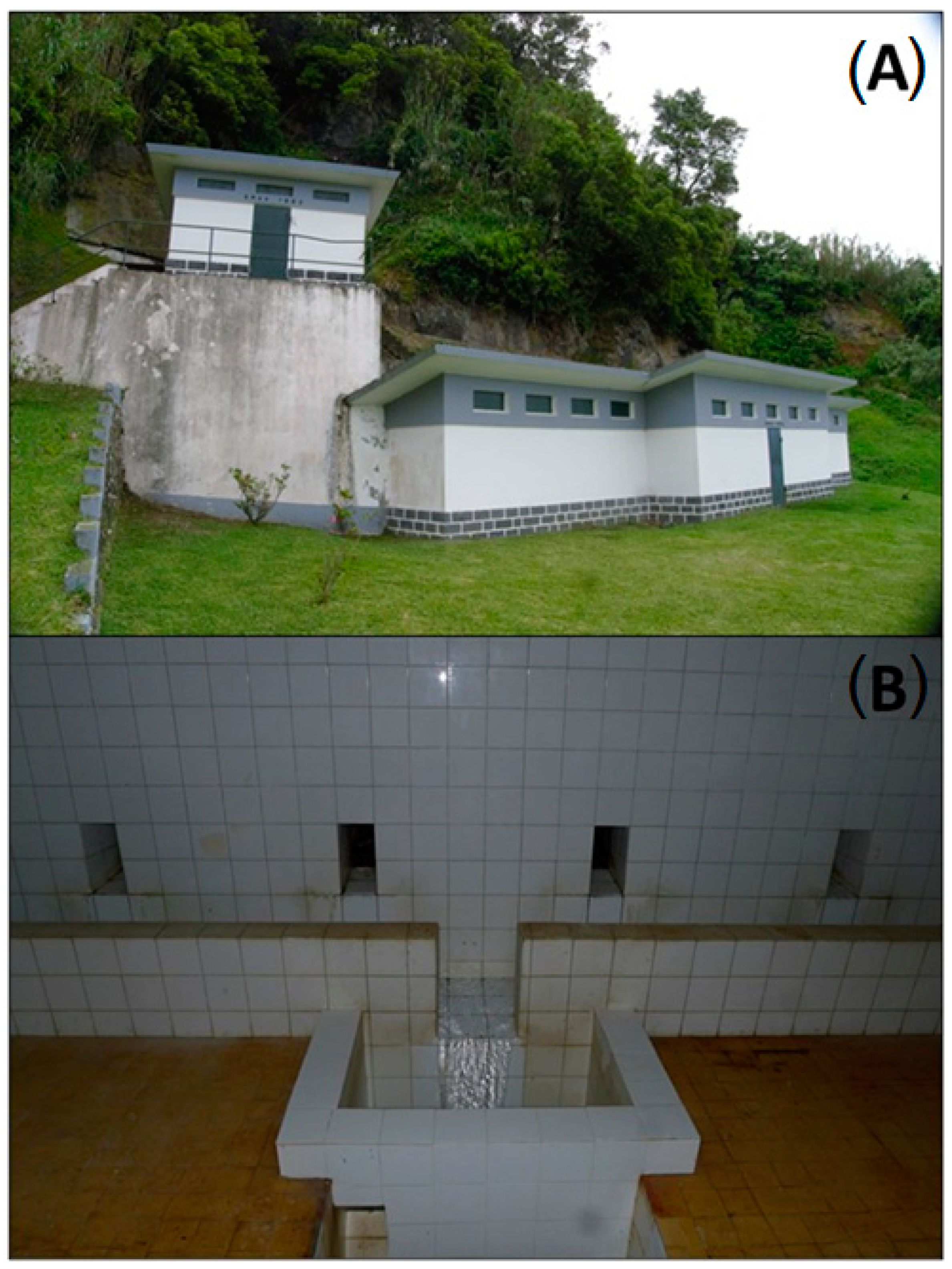
2.2. The Water Supply System of Ponta Delgada

The water supply on São Miguel is fully assured by the six municipalities, with 100% of the 137,307 inhabitants being served. The 60 water supply zones on the island are vertically integrated and are run directly by four municipalities (Lagoa, Ribeira Grande, Vila Franca do Campo and Povoação), while the other two are run indirectly through a municipal company and a semi-autonomous service provider [48]. The mean number of inhabitants per water system is equal to 2311. On the island, a total of 157 groundwater sources are nowadays abstracted, corresponding to a volume of 2.53 × 10⁷ m3/a, contrasting to a single surface water source exploited for human supply (6.23 × 10⁷ m3/a) [39].
The Ponta Delgada water supply system serves a total of 68,392 inhabitants and corresponds to a vertically integrated system run indirectly by the Ponta Delgada municipality through a semi-autonomous water services utility company (Serviços Municipalizados de Água e Saneamento de Ponta Delgada—SMAS).
The supply system is divided into 18 zones (Figure 1D), based on the homogeneity of the water sources that feed the system. All the water is abstracted from groundwater bodies, namely through 46 springs or groups of springs and four drilled wells (despite a larger number that can be exploited), corresponding to a mean volume of about 42,545 m3/day (2019; SMAS). The volume of water abstracted has been relatively constant since 2003, reflecting the influence of the springs presenting higher discharge rates, where seasonal variations are nonexistent [32], and in 2018 the overall abstracted volume was estimated as equal to 1.42 × 10⁷ m3/a [49].
Springs correspond to discharges from perched aquifers in the Sete Cidades and Água de Pau groundwater bodies (Figure 1C), respectively, toward the west and the east, with the latter being used also to transfer water to systems run by the Ribeira Grande and Lagoa municipalities. These springs are located at various altitudes on the flanks of the quaternary central volcanoes of Sete Cidades and Fogo, such as, for example, the so-called Chã dos Tanques (Figure 2). Hydrogeological studies have shown that in the Azores discharge is generally higher in springs from lava flow aquifers, basaltic or trachytic in nature, compared to discharges from aquifers made of pyroclastic deposits. Discharge is also often higher in winter than in summer [50], presenting an inverse linear relationship between the elevation of the discharge and the water conductivity, which suggests that groundwater discharging at the high-altitude springs have a lower residence time [51].
The Sete Cidades and Fogo central volcanoes are linked by a volcanic fissural zone (Picos Fissural Volcanic System), corresponding to a flatter area at a lower altitude where wells were drilled in the last decades, abstracting groundwater from perched or from basal aquifers. This fissural system corresponds to the so-called Ponta Delgada–Fenais da Luz groundwater body, and drilled wells present depths in the range 89 m up to 284 m, with a mean transmissivity of 3 × 10⁻² m2/s.
Water storage is ensured by using 61 reservoirs, mainly ground reservoirs, corresponding to a total capacity of 48,790 m3 and the system also includes nearly 710 km of pipes. Coupled to reservoirs, water treatment is made in 33 treatment stations through chlorination. As the groundwater abstracted in springs is mainly of acid soft waters type, it requires only a simple correction of pH and hardness, which is typically made in the spring capture using tanks with limestone fragments in the bottom. Generally, the supplied water is of very good quality, complying to normative values and monitoring demands, despite some concerns about abnormal fluoride content in some springs [32].
Water usage in Ponta Delgada is dominated by domestic supply, which corresponds to about 3.34 × 10⁶ m3/a (year 2018; [52]), to which 3.39 × 10⁵ m3/a (commerce and services) must be added to estimate urban water services. The water supply system managed by SMAS also provided 9.03 × 10⁵ m3/a for social purposes and temporary supplies, about 7.53 × 10⁵ m3/a to other public demands, as well as 8.36 × 10⁵ m3/a and 5.42 × 10⁵ m3/a to agriculture and industry, respectively [52]. The volume of water charged by SMAS to water users in 2018 was equal to 6.54 × 10⁶ m3/a [52], and the leaks in the system were computed at more than 40%, which justifies the gap to the volume of water being abstracted annually [49].

2.3. Methodology

The potential impact of explosive volcanic eruptions on the water supply system of Ponta Delgada was evaluated through the application of vulnerability matrices. In the present paper mainly the physical vulnerability is approached, in the sense presented by [53], representing the susceptibility to tephra fall associated with trachytic explosive eruptions from the Sete Cidades Volcano.
The first step in the assessment of the impact of tephra fall deposition on the water supply systems was the definition of eruptive scenarios. This is a common approach used to assess volcanic hazard, as it helps to mitigate the impacts of future eruptions by anticipating the consequences that may occur [54]. For this paper, two of the eruptive scenarios of [44] were selected, which were obtained from the reconstruction of the violent sub-Plinian phase of the Santa Bárbara eruption [43,44]. The numerical simulations of tephra fall scenarios were obtained using an advection–diffusion model (for details see [55]) in the Volcanic Risk Information System (VORIS) 2.0.1 tool [56], implemented in a GIS framework, which allows for the rapid visualization of the simulation results. This methodology has been successfully applied to other cases, such as of Deception Island, Antarctica [57], El Hierro and Lanzarote, Canary Islands [54,58] and Fogo Volcano (São Miguel) [33].
Eruptive scenario A (corresponding to scenario 2 of [44]) reconstructs the known distribution and thickness of the tephra fall deposit of the Santa Bárbara eruption. The main eruptive source parameters used in scenario A were an erupted bulk volume of 0.27 km3 and an eruption column height of 17,000 m, which are in the same range of values estimated for some of the recent (<5000 years) sub-Plinian eruptions of the Sete Cidades Volcano [42,59]. Therefore, it can be taken as a proxy for future explosive eruptions. The wind conditions used correspond to a vertical profile with wind directions ranging from SW-blowing winds at lower altitudes to WNW-blowing winds at higher altitudes.
Eruptive scenario B (corresponding to scenario 3 of [44]) simulates a hypothetical future explosive eruption with the same eruptive source parameters as in scenario A, but with a unidirectional NW-blowing wind profile. It reproduces a worst-case scenario of a violent sub-Plinian eruption of the Sete Cidades Volcano under wind conditions blowing toward Ponta Delgada city. Given the westerly prevailing winds throughout most of the year in the Azores region (see wind statistical analysis in [33,38]), scenario B is a plausible most hazardous scenario with the highest impact on critical infrastructure of Ponta Delgada municipality.
The main input parameters used for the simulations of eruptive scenarios A and B with the VORIS 2.0.1 tool are shown in Table 1 (for further details see [44]).
Vulnerability matrices were applied to compute indexes, as through these matrices, the thickness of tephra fall deposits, corresponding to an increasing hazard level, is multiplied by descriptors of the water supply system, representing the elements at risk. For this latter purpose, the elements at risk considered in this study were the volume of water being abstracted (Table 2), the storage capacity of the reservoirs (Table 3) and the number of inhabitants being served by the system (Table 4). The application of this semi-quantitative approach does not require ex-ante data [60] and may provide an important insight into the definition of strategies and structural measures for risk mitigation [61]. Nevertheless, as only one single volcanic hazard (tephra fall) is addressed, difficulties associated with a multi-hazard analysis are avoided, despite recognizing that in volcanic regions this approach may be of higher value as these areas are affected by a large array of hazardous phenomena [62].
Threshold values for tephra fall thickness used in Table 2, Table 3 and Table 4 were taken from [3]. For springs the increasing hazard levels are, respectively, equal to 1 to 20 mm, 20 to 100 mm and higher than 100 mm, while for values lower than 1 mm no damage/disruption is expected (Table 2). If along the first level (1 to 20 mm), clogging of filters and some abrasion occurs, as well as higher water turbidity, the following levels may depict an increasing deterioration of the water quality, damages to pumping equipment, infilling of tanks and in the limit the collapse of the water source roofs [3]. The same threshold values were considered for the analysis of the number of inhabitants being affected (Table 4). Indices in the matrix were classified as representative of a tolerance status (1–4), of disturbance (5–9) and of damage (10–15). Five classes were considered for the spring discharge (Table 2), taking into account data for the several sources being abstracted [32].
For reservoirs, the hazard levels used are, respectively, equal to 10 to 100 mm, 100 to 500 mm and higher than 500 mm, and for values lower than 10 mm no damage/disruption in the building is expected (Table 3). These threshold values are the same as those proposed by [3] for buildings, more appropriate for the type of reservoirs in the Ponta Delgada water supply system. For the first level (10 to 100 mm), only light roof damages are expected, with abrasion of windows and cladding; nevertheless, tephra will infiltrate the interior of the building [3]. Roof damages will increase along the following levels, from severe to total collapse, as well as the extent of damages in the buildings. The expected amount of tephra inside the reservoirs will also be much higher. Five classes were considered for the storage capacity (Table 3), considering data for the several water reservoirs that made the water supply system of Ponta Delgada [32].
Finally, for the vulnerability matrix based on the number of inhabitants being served by the system, five classes were considered regarding the number of people served in each of the 18 water supply zones into which the system is subdivided (Table 4).
As the water treatment stations are in the main reservoirs, results for the latter structures also reflect any constraints to the treatment capability following explosive volcanic eruptions.
Despite groundwater-based water supply systems perhaps being less vulnerable to tephra fall than surface water-fed systems or wastewater facilities, which are not addressed in this paper, well-head equipment is still vulnerable [5]. Moreover, the water supply system design is instrumental in what concerns impact occurrence and severity [4], and in the present case study spring-fed sources will also be impacted as suspended ash will penetrate inside the infrastructure, which may cause blockage of the water intake, and filter and pipe clogging, besides the possibility of the damages to the overall infrastructure. Tephra-water slurries may also cause clogging [3]. Poor water quality is also to be expected due to the deposition of tephra inside the water sources infrastructure and in the recharge areas.

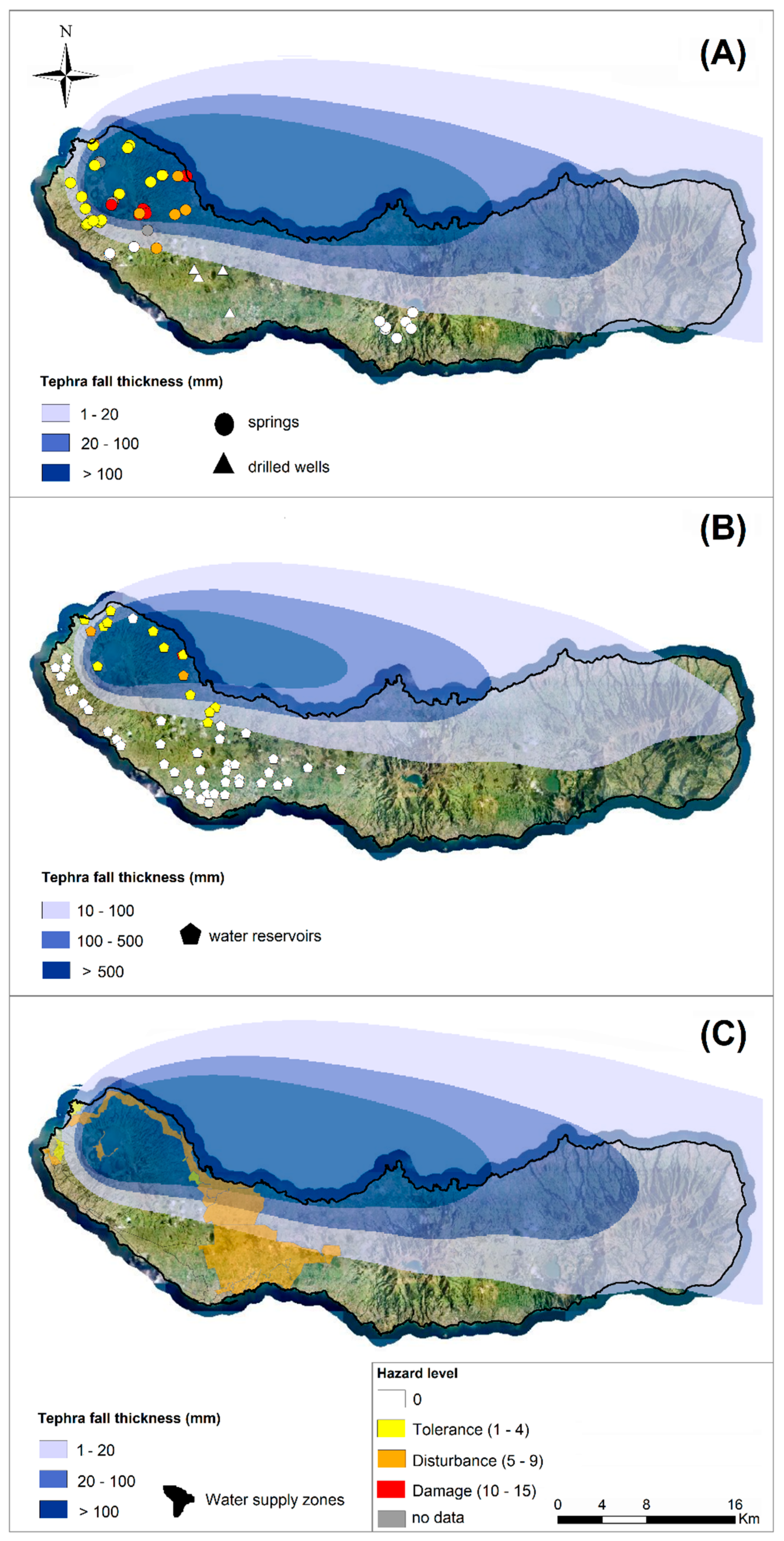
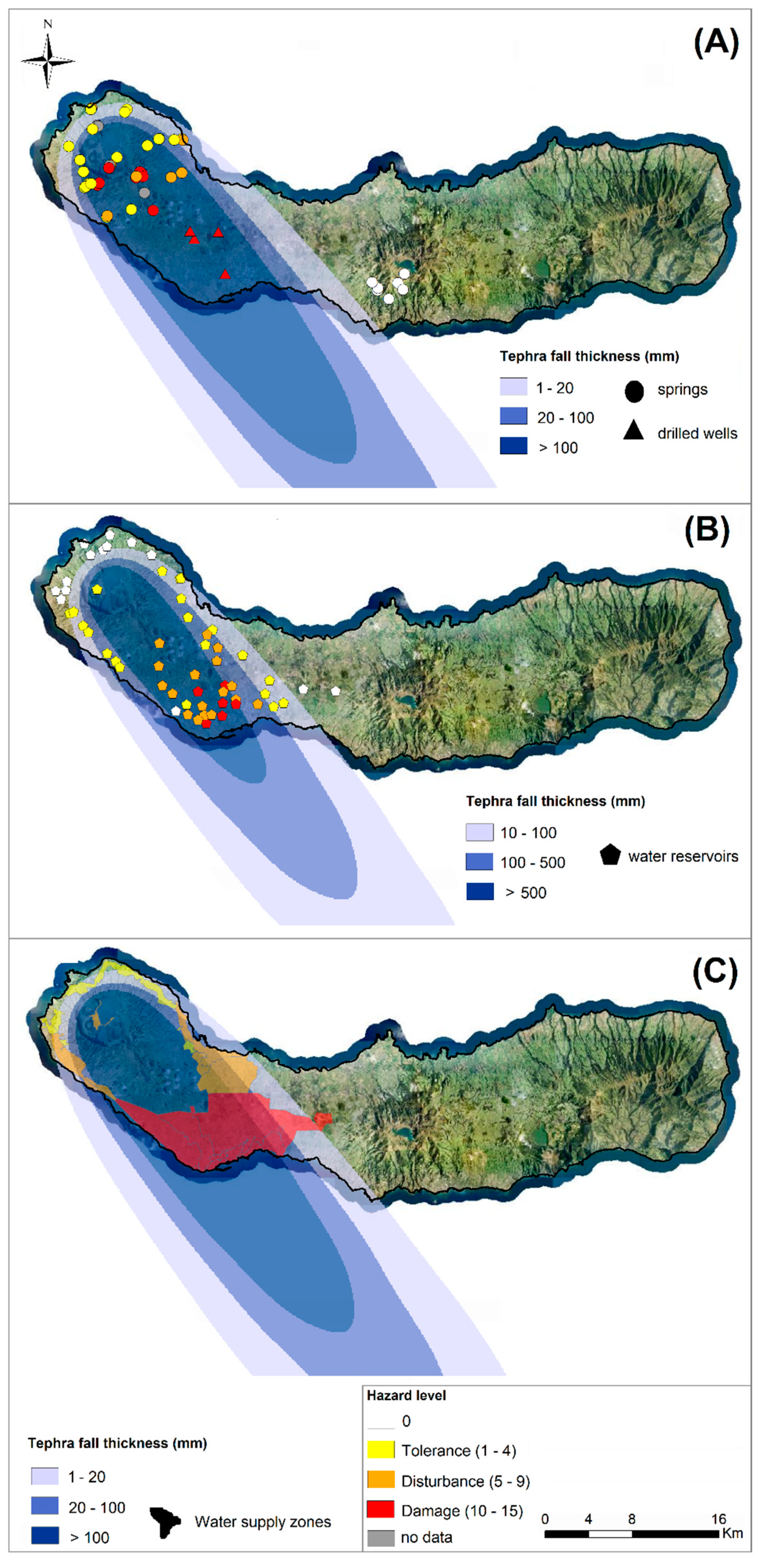
3. Results and Discussion

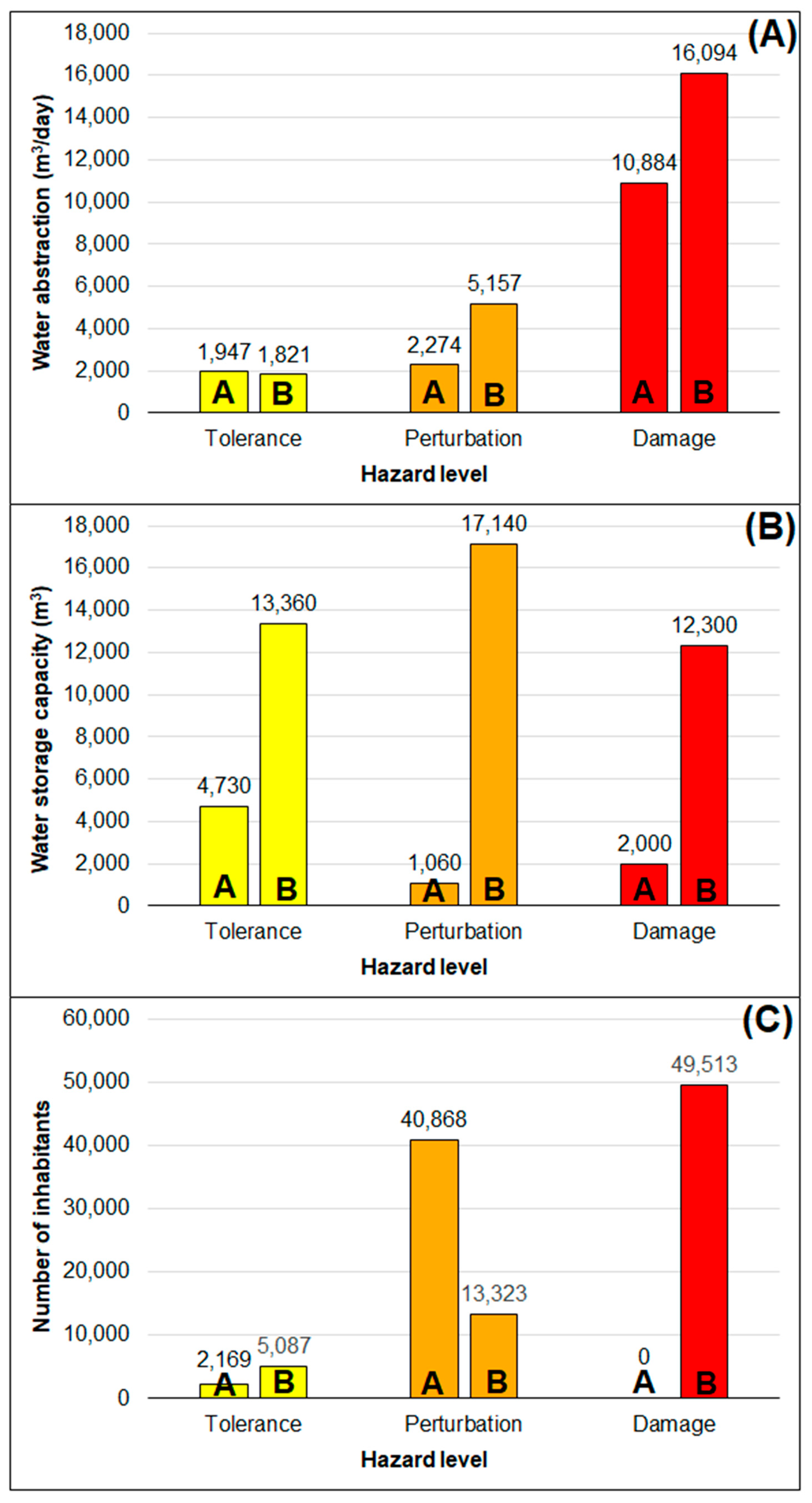
3.1. Impacts on Water Abstraction

The impacts of the two eruptive scenarios on the water supply system of Ponta Delgada are shown in Figure 3 and Figure 4, respectively, for scenarios A and B. In scenario A, tephra fall deposits extend mostly to the north coast of São Miguel, while in scenario B tephra covers a much larger area inland, thus impacting at a larger scale the water supply infrastructure.
According to scenario A, 70.5% of the springs that feed the water supply are impacted (31 springs from a total of 44); nevertheless, the remaining 29.5% (13 springs) represent a major portion of the total abstraction (Figure 3A). The latter group is responsible for 64.5% of the total daily abstraction (27,446 m3/day). In 17 springs, the hazard level is tolerable, corresponding to a volume abstracted of 1947 m3/day (4.6% of the total daily volume), in six springs the level is of perturbance (2274 m3/day; 5.3% of the total) and in seven springs the level is of damage (10,884 m3/day; 25.6% of the total) (Figure 3A and Figure 5A). The drilled wells area was not affected in this scenario.
If the tolerance level only requires an increasing frequency of maintenance operations, due to clogging of filters and equipment abrasion in the spring abstraction infrastructure, the disturbance level may imply restrictions on the water usage, due to damages to equipment or water pollution. These impacts are aggravated in the damage hazard level, where the water source infrastructure may collapse and the expected water pollution risk increases.
Scenario B reveals that only 15.2% of the springs (seven of a total of 46) are not affected at any level by tephra fall deposits, namely the ones located at Água de Pau groundwater body (Figure 1C,D and Figure 4A). Instead, springs spread over Sete Cidades groundwater body, as well as all the drilled wells in the Ponta Delgada–Fenais da Luz groundwater body, are affected by the deposition of tephra. In 18 springs the hazard level is tolerable, corresponding to 1821 m3/day (4.3% of the total daily volume), but in 12 springs the expected level is of perturbation (5157 m3/day; 12.1%) or damage (16,094 m3/day; 37.8%) (Figure 4A and Figure 5A). The latter percentages show how scenario B has a much larger impact compared to scenario A, severely constraining the daily abstraction of water to public supply.

3.2. Impacts on Water Storage

The water storage capacity is also strongly impacted on both scenarios, but with different magnitudes. According to scenario A, in 12 reservoirs the hazard level is of tolerance, corresponding to a storage capacity of 4730 m3 (9.7% of the total capacity), and in the other two the hazard is of perturbation (1060 m3; 2.2%) (Figure 3B and Figure 5B). The damage level only occurs in a single reservoir, corresponding to a storage volume of 2000 m3 (4.1%).
If within the tolerance level only small damage in the roofs and abrasion of doors, windows and cladding of the reservoirs is to be expected, thus not constraining the storage capacity, with the perturbation level partial collapses of the infrastructure may occur, as well as serious damage in roofs and vertical structures, thus compromising water storage volume. The water storage is fully compromised at the damage level, as damages are beyond repair, as total roof collapse may occur as well as severe damage to the remaining structures.
The overall storage volume is strongly aggravated with scenario B, as 75.4% of the reservoirs may be affected, corresponding to 87.7% of the overall storage capacity of the water supply system (Figure 4B and Figure 5B). A total of 22 reservoirs are at the tolerance level (13,360 m3; 27.4% of the total), 18 at the perturbance level (17,140 m3; 35.1%) and six at the damage level (12,300 m3; 25.2%).

3.3. Impacts on Water Supply Zones

Using the same hazard levels applied for the water sources and considering the overall number of inhabitants served by each water supply zone, scenario A reveals that in four zones the level is of tolerance, with 2169 inhabitants affected (3.2% of the total). In other eight water supply zones the level is of perturbance (40,868 inhabitants; 59.6%) (Figure 3C and Figure 5C).
Scenario B affects six zones (33% of the total) with a tolerance hazard level (5087 inhabitants; 7.4%), another six zones depict a perturbation level (13,323; 19.5%) and five present a damage hazard level (Figure 4C and Figure 5C). The latter ones correspond to 49,513 inhabitants, 72.4% of the total population served by the Ponta Delgada water supply system.

3.4. Prepradness Measures and Forthcoming Research

The main findings suggest that the water supply system of Ponta Delgada can be severely impacted by an explosive eruption at the Sete Cidades Volcano. Moreover, despite not being analyzed in the present paper, an explosive eruption at the nearby Fogo Volcano also has the potential to disrupt the water supply system, as suggested by volcanological studies [12,33], both by directly affecting springs located in the Água de Pau groundwater body or by tephra deposition toward the west if the wind conditions are favorable. Therefore, a set of preventive measures must be adopted to mitigate the potential effects of a future explosive eruption. Several actions have been recommended to water supply managers in the literature [63], such as further protection of the water intakes and the empowerment of water monitoring, besides the increase of spare technical components.
Taken as priority criteria for the springs/wells, or similarly the reservoirs, that depict a higher hazard index for both eruptive scenarios, the water intake protection should be reinforced to prevent physical damages and avoid water turbidity increase, maintaining the interiors as cleanly as possible. Moreover, air thigh conditions will also allow a higher protection of any indoor equipment, such as electrical control panels or chlorination devices (in reservoirs).
An overall increase of the storage capacity, as well as creating conditions for water transfer between water supply zones in the system, also have to be prepared to allow a response to a volcanic crisis, or to anticipate the increasing water demand for cleaning operations in the aftermath of the eruption. The identification of alternative routes toward water intakes and reservoirs, facilitating cleaning operations in the facilities and personnel training will also be useful for a prompt response.
Monitoring of water quality is also to be reinforced during and in the aftermath of the eruption, to allow any adjustment to be made in the water treatment operations, for example, due to acidity decrease or higher water turbidity, or to control some elemental contamination from toxic elements (e.g., fluoride). Preparedness should also include analyzing tephra to characterize those toxic elements’ leaching (Al, As, Cd, Cr, Cu, F, Fe, Mn, Ni, Pb, Zn) to which some protocols have been already developed [64].
The geology of the Azores depicts a large array of eruptive styles, from more effusive eruptions to highly explosive events, thus other eruptive scenarios must be fully investigated in the future to consider water supply as a major issue of civil defense in the Azores archipelago, in general, and in São Miguel Island, in particular.
Figure 3. Cartographic representation of the impacts of eruptive scenario A, respectively, for: (A) Volume of water being abstracted; (B) storage capacity of the reservoirs; (C) number of inhabitants being served by the system over the water supply system of Ponta Delgada.
Water 14 01022 g003
Figure 4. Cartographic representation of the impacts of eruptive scenario B, respectively, for: (A) Volume of water being abstracted; (B) storage capacity of the reservoirs; (C) number of inhabitants being served by the system over the water supply system of Ponta Delgada.
Water 14 01022 g004
Figure 5. Comparison of the two eruptive scenarios (A,B), respectively, for: (A) Volume of water being abstracted; (B) storage capacity of the reservoirs; (C) number of inhabitants being served by the system over the water supply system of Ponta Delgada.
Water 14 01022 g005

4. Conclusions

Ponta Delgada is the municipality with the largest population in the Azores and is located in the vicinity of two active central volcanoes (Sete Cidades and Fogo). Therefore, the water supply system in this area, which serves a total of 68,392 inhabitants, may be affected by volcanic eruptions in the future, with severe consequences if the supply is partially or totally interrupted. Moreover, the location of the water captures, mainly spread in the flanks of these volcanoes, as well as the widespread distribution of the urban areas along the coastal area of the municipality, poses additional difficulties in preventing or mitigating the consequences of an eruption over the water supply system.
The present study also points to the need for the municipal emergency plan to provide measures specifically focused on protecting the water supply, to maintain it during and after a volcanic crisis with a minimum of constraints. The results of this paper can serve as a benchmark for other municipalities in the Azores, where the issue of water supply during and after a volcanic event is equally crucial and stresses the need to develop such studies in the near future.

Supplementary Materials

The following supporting information can be downloaded at: https://www.mdpi.com/article/10.3390/w14071022/s1, Figure S1: Location of the Azores archipelago in the North Atlantic Ocean.

Author Contributions

Conceptualization, J.V.C. and F.V.; methodology, J.V.C., F.V., A.P., C.A., J.N. and S.C.; software, C.A.; investigation, F.V. and J.V.C.; validation, J.V.C.; writing—original draft preparation, J.V.C., F.V. and A.P.; writing—review and editing, J.V.C. and R.C.; visualization, C.A.; supervision, J.V.C. All authors have read and agreed to the published version of the manuscript.

Funding

This research received no external funding.

Institutional Review Board Statement

Not applicable.

Informed Consent Statement

Not applicable.

Data Availability Statement

The data presented in this study are available on request from the corresponding author.

Acknowledgments

The authors wish to express their gratitude to the Serviços Municipalizados de Água e Saneamento de Ponta Delgada for their valuable support to the research, namely by the data kindly made available.

Conflicts of Interest

The authors declare no conflict of interest.

References

  1. Schmincke, H.-U. Volcanism; Springer: Berlin/Heidelberg, Germany, 2004; p. 324. [Google Scholar]
  2. Francis, P.; Oppenheimer, C. Volcanoes, 2nd ed.; Oxford University Press: Oxford, UK, 2004; p. 521. [Google Scholar]
  3. Wilson, G.; Wilson, T.M.; Deligne, N.I.; Cole, J.W. Volcanic hazard impacts to critical infrastructure: A review. J. Volcanol. Geotherm. Res. 2014, 286, 148–182. [Google Scholar] [CrossRef] [Green Version]
  4. Stewart, C.; Wilson, T.M.; Leonard, G.S.; Johnston, D.M.; Cole, J.W. Volcanic hazards and water shortages. In Water Shortages: Environmental Economic and Social Impacts; Briggs, A.C., Ed.; Nova Publishing: New York, NY, USA, 2010; pp. 105–124. [Google Scholar]
  5. Wilson, T.M.; Stewart, C.; Sword-Daniels, V.; Leonard, G.S.; Johnston, D.M.; Cole, J.W.; Wardman, J.; Wilson, G.; Barnard, S.T. Volcanic ash impacts on critical infrastructure. Phys. Chem. Earth 2012, 45–46, 5–23. [Google Scholar] [CrossRef]
  6. Johnston, D.; Stewart, C.; Leonard, G.S.; Hoverd, J.; Thordasson, T.; Cronin, S. Impacts of Volcanic Ash on Water Supplies in Auckland: Part I. Institute of Geological & Nuclear Sciences Science Report 2004/25; Institute of Geological & Nuclear Sciences Limited: Lower Hutt, New Zealand, 2004. [Google Scholar]
  7. Michaud-Dubuy, A.; Carazzo, G.; Kaminski, E. Volcanic hazard assessment for tephra fallout in Martinique. J. Appl. Volcanol. 2021, 10, 8. [Google Scholar] [CrossRef]
  8. Stewart, C.; Johston, D.M.; Leonard, G.; Horwell, C.J.; Thordason, T.; Cronin, S. Contamination of water supplies by volcanic ashfall: A literature review and simple impact modelling. J. Volcanol. Geotherm. Res. 2006, 158, 296–306. [Google Scholar] [CrossRef]
  9. Wilson, G.; Wilson, T.M.; Deligne, N.I.; Blake, D.M.; Cole, J.W. Framework for developing volcanic fragility and vulnerability functions for critical infrastructure. J. Appl. Volcanol. 2017, 6, 14. [Google Scholar] [CrossRef] [Green Version]
  10. Wilson, T.M.; Cole, J.W.; Stewart, C.; Cronin, S.J.; Johnston, D.M. Ash storms: Impacts of wind-remobilised volcanic ash on rural communities and agriculture following the 1991 Hudson eruption, southern Patagonia, Chile. Bull. Volcanol. 2010, 73, 223–239. [Google Scholar] [CrossRef]
  11. Wild, A.J.; Wilson, T.M.; Bebbington, M.S.; Cole, J.W.; Craig, H.M. Probabilistic volcanic impact assessment and cost-benefit analysis on network infrastructure for secondary evacuation of farm livestock: A case study from the dairy industry, Taranaki, New Zealand. J. Volcanol. Geotherm. Res. 2019, 387, 106670. [Google Scholar] [CrossRef]
  12. Booth, B.; Croasdale, R.; Walker, G. A quantitative study of five thousand years of volcanism on São Miguel, Azores. Philos. Trans. R. Soc. Lond. 1978, 288, 271–319. [Google Scholar]
  13. Moore, R.B. Volcanic geology and eruption frequency, São Miguel, Azores. Bull. Volcanol. 1990, 52, 602–614. [Google Scholar] [CrossRef]
  14. Guest, J.E.; Gaspar, J.L.; Cole, P.D.; Queiroz, G.; Duncan, A.M.; Wallenstein, N.; Ferreira, T.; Pacheco, J.M. Volcanic geology of Furnas volcano, São Miguel, Azores. J. Volcanol. Geotherm. Res. 1999, 92, 1–29. [Google Scholar] [CrossRef]
  15. Pacheco, J.M.; Ferreira, T.; Queiroz, G.; Wallenstein, N.; Coutinho, R.; Cruz, J.V.; Pimentel, A.; Silva, R.; Gaspar, J.L.; Goulart, C. Notas sobre a geologia do arquipélago dos Açores. In Geologia de Portugal; Dias, R., Araújo, A., Terrinha, P., Kullberg, J.C., Eds.; Escolar Editora: Lisboa, Portugal, 2013; pp. 595–690. (In Portuguese) [Google Scholar]
  16. Queiroz, G.; Gaspar, J.L.; Guest, J.E.; Gomes, A.; Almeida, M.H. Eruptive history and evolution of Sete Cidades Volcano, São Miguel Island, Azores. In Volcanic Geology of São Miguel Island (Azores Archipelago); Gaspar, J.L., Guest, J.E., Duncan, A.M., Barriga, F., Chester, D.K., Eds.; Geological Society: London, UK, 2015; Memoirs 44; pp. 87–104. [Google Scholar]
  17. Wallenstein, N.; Chester, D.; Coutinho, R.; Duncan, A.; Dibben, C. Volcanic hazard vulnerability on São Miguel Island, Azores. In Volcanic Geology of São Miguel Island (Azores Archipelago); Gaspar, J.L., Guest, J.E., Duncan, A.M., Barriga, F., Chester, D.K., Eds.; Geological Society: London, UK, 2015; Memoirs 44; pp. 213–225. [Google Scholar]
  18. Guest, J.E.; Pacheco, J.M.; Cole, P.D.; Duncan, A.M.; Wallenstein, N.; Queiroz, G.; Gaspar, J.L.; Ferreira, T. The volcanic history of Furnas Volcano, São Miguel, Azores. In Volcanic Geology of São Miguel Island (Azores Archipelago); Gaspar, J.L., Guest, J.E., Duncan, A.M., Barriga, F., Chester, D.K., Eds.; Geological Society: London, UK, 2015; Memoirs 44; pp. 125–134. [Google Scholar]
  19. Ferreira, T.; Gomes, A.; Gaspar, J.L.; Guest, J. Distribution and significance of basaltic eruptive centres: Sâo Miguel, Azores. In Volcanic Geology of São Miguel Island (Azores Archipelago); Gaspar, J.L., Guest, J.E., Duncan, A.M., Barriga, F., Chester, D.K., Eds.; Geological Society: London, UK, 2015; Memoirs 44; pp. 135–146. [Google Scholar]
  20. Viveiros, F.; Ferreira, T.; Cabral Vieira, J.; Silva, C.; Gaspar, J.L. Environmental influences on soil CO2 degassing at Furnas and Fogo volcanoes (São Miguel Island, Azores archipelago). J. Volcanol. Geotherm. Res. 2008, 177, 883–893. [Google Scholar] [CrossRef]
  21. Viveiros, F.; Cardellini, C.; Ferreira, T.; Caliro, S.; Chiodini, G.; Silva, C. Soil CO2 emissions at Furnas volcano, São Miguel Island, Azores archipelago: Volcano monitoring perspectives, geomorphologic studies, and land use planning application. J. Geophys. Res. 2010, 115, B12208. [Google Scholar] [CrossRef]
  22. Cruz, J.V.; Coutinho, R.M.; Carvalho, M.R.; Oskarsson, N.; Gislason, S.R. Chemistry of waters from Furnas volcano, São Miguel, Azores: Fluxes of volcanic carbon dioxide and leached material. J. Volcanol. Geotherm. Res. 1999, 92, 151–167. [Google Scholar] [CrossRef]
  23. Freire, P.; Andrade, C.; Coutinho, R.; Cruz, J.V. Spring geochemistry in an active volcanic environment (São Miguel, Azores): Source and fluxes of inorganic solutes. Sci. Total Environ. 2013, 454–455, 154–169. [Google Scholar] [CrossRef]
  24. Andrade, C.; Viveiros, F.; Cruz, J.V.; Coutinho, R. Global carbon dioxide output of volcanic lakes in the Azores archipelago, Portugal. J. Geochem. Explor. 2021, 229, 106835. [Google Scholar] [CrossRef]
  25. Branco, R.; Cruz, J.V.; Silva, C.; Coutinho, R.; Andrade, C.; Zanon, V. Radon (222Rn) occurrence in groundwater bodies on São Miguel Island (Azores archipelago, Portugal). Environ. Earth Sci. 2021, 80, 609. [Google Scholar] [CrossRef]
  26. Andrade, C.; Trigo, R.M.; Freitas, M.C.; Gallego, M.C.; Borges, P.; Ramos, A.M. Comparing historic records of storm frequency and the North Atlantic Oscillation (NAO) chronology for the Azores region. Holocene 2008, 18, 745–754. [Google Scholar] [CrossRef] [Green Version]
  27. Valadão, P.; Gaspar, J.L.; Queiroz, G.; Ferreira, T. Landslide density map of S. Miguel Island, Azores archipelago. Nat. Hazards Earth Syst. Sci. 2002, 2, 51–56. [Google Scholar] [CrossRef]
  28. Marques, R. Estudo de Movimentos de Vertente no Concelho da Povoação (ilha de São Miguel, Açores): Inventariação, Caracterização e Análise da Susceptibilidade. Ph.D. Thesis, Universidade dos Açores, Ponta Delgada, Portugal, 2013. (In Portuguese). [Google Scholar]
  29. Wallenstein, N.; Chester, D.K.; Duncan, A.M. Methodological implications of volcanic hazard evaluation and risk assessment: Fogo Volcano, São Miguel, Azores. Z. För Geomorphol. Suppl. 2005, 140, 129–149. [Google Scholar]
  30. Wallenstein, N.; Duncan, A.; Chester, D.; Marques, R. Fogo Volcano (São Miguel, Azores): A hazardous edifice Le volcan Fogo, un édifice générateur d’aléas indirects. Géomorphologie Relief Processus Environ. 2007, 3, 259–270. [Google Scholar] [CrossRef] [Green Version]
  31. Pacheco, D.; Mendes, S.; Cymbron, R. Azores assessment and management of floods risks. In Advances in Natural Hazards and Hydrological Risks: Meeting the Challenge, Proceedings of the 2nd International Workshop on Natural Hazards (NATHAZ’19), Lajes do Pico, Portugal, 9–10 May 2019; Fernandes, F., Malheiro, A., Chaminé, H., Eds.; Springer Nature: Cham, Switzerland, 2020; pp. 133–136. [Google Scholar]
  32. Cordeiro, S.; Coutinho, R.; Cruz, J.V. Fluoride content in drinking water supply in São Miguel volcanic island (Azores, Portugal). Sci. Total Environ. 2012, 432, 23–36. [Google Scholar] [CrossRef] [PubMed]
  33. Medeiros, J.; Carmo, R.; Pimentel, A.; Vieira, J.C.; Queiroz, G. Assessing the impact of explosive eruptions of Fogo volcano (São Miguel, Azores) on the tourism economy. Nat. Hazards Earth Syst. Sci. 2021, 21, 417–437. [Google Scholar] [CrossRef]
  34. Pomonis, A.; Spence, R.; Baxter, P. Risk assessment of residential buildings for an eruption of Furnas Volcano, São Miguel the Azores. J. Volcanol. Geotherm. Res. 1999, 92, 107–131. [Google Scholar] [CrossRef]
  35. Dibben, C.; Chester, D.K. Human vulnerability in volcanic environments: The case of Furnas Volcano, São Miguel, Azores. J. Volcanol. Geotherm. Res. 1999, 92, 133–150. [Google Scholar] [CrossRef]
  36. Baxter, P.J.; Baubron, J.C.; Coutinho, R. Health hazards and disaster potential of ground gas emission at Furnas Volcano, São Miguel, Azores. J. Volcanol. Geotherm. Res. 1999, 92, 95–106. [Google Scholar] [CrossRef]
  37. Wallenstein, N.; Duncan, A.; Guest, J.E.; Almeida, M.H. Eruptive history of Fogo Volcano, São Miguel, Azores. In Volcanic Geology of São Miguel Island (Azores Archipelago); Gaspar, J.L., Guest, J.E., Duncan, A.M., Barriga, F., Chester, D.K., Eds.; Geological Society: London, UK, 2015; Memoirs 44; pp. 105–123. [Google Scholar]
  38. Gaspar, J.L.; Guest, J.E.; Queiroz, G.; Pacheco, J.M.; Pimentel, A.; Gomes, A.; Marques, R.; Felpeto, A.; Ferreira, T.; Wallenstein, N. Eruptive frequency and volcanic hazards zonation in São Miguel Island, Azores. In Volcanic Geology of São Miguel Island (Azores Archipelago); Gaspar, J.L., Guest, J.E., Duncan, A.M., Barriga, F., Chester, D.K., Eds.; Geological Society: London, UK, 2015; Memoirs 44; pp. 155–166. [Google Scholar]
  39. AHA-DRA. Plano de Gestão da Região Hidrográfica dos Açores—RH9. Versão para consulta pública (Azores River Basin Management Plan). In Report AHA-SRAM; Direção Regional do Ordenamento do Território e dos Recursos Hídricos: Ponta Delgada, Portugal, 2015. (In Portuguese) [Google Scholar]
  40. Duncan, A.M.; Guest, J.E.; Wallenstein, N.; Chester, D.K. The older volcanic complexes of São Miguel, Azores: Nordeste and Povoação. In Volcanic Geology of São Miguel Island (Azores Archipelago); Gaspar, J.L., Guest, J.E., Duncan, A.M., Barriga, F., Chester, D.K., Eds.; Geological Society: London, UK, 2015; Memoirs 44; pp. 147–153. [Google Scholar]
  41. Queiroz, G. Vulcão das Sete Cidades (S.Miguel, Açores)—História Eruptiva e Avaliação do Hazard. Ph.D. Thesis, Universidade dos Açores, Ponta Delgada, Portugal, 1998. (In Portuguese). [Google Scholar]
  42. Queiroz, G.; Pacheco, J.M.; Gaspar, J.L.; Aspinall, W.P.; Guest, J.E.; Ferreira, T. The last 5000 years of activity at Sete Cidades volcano (São Miguel Island, Azores): Implications for hazard assessment. J. Volcanol. Geotherm. Res. 2008, 178, 562–573. [Google Scholar] [CrossRef]
  43. Porreca, M.; Pimentel, A.; Kueppers, U.; Izquierdo, T.; Pacheco, J.; Queiroz, G. Event stratigraphy and emplacement mechanisms of the last major caldera eruption on Sete Cidades Volcano (São Miguel, Azores): The 16 ka Santa Bárbara Formation. Bull. Volcanol. 2018, 80, 76. [Google Scholar] [CrossRef]
  44. Kueppers, U.; Pimentel, A.; Ellis, B.; Forni, F.; Neukampf, J.; Pacheco, J.; Perugini, D.; Queiroz, G. Biased Volcanic Hazard Assessment Due to Incomplete Eruption Records on Ocean Islands: An Example of Sete Cidades Volcano, Azores. Front. Earth Sci. 2019, 7, 122. [Google Scholar] [CrossRef] [Green Version]
  45. DROTRH-INAG. Plano Regional da Água. Relatório Técnico; DROTRH-INAG: Ponta Delgada, Portugal, 2001. (In Portuguese)
  46. Cruz, J.V.; Freire, P.; Costa, A.; Fontiela, J.; Cabral, L.; Coutinho, R. Hydrogeochemical characterization of mineral waters in São Miguel Island, Azores. In Volcanic Geology of São Miguel Island (Azores Archipelago); Gaspar, J.L., Guest, J.E., Duncan, A.M., Barriga, F., Chester, D.K., Eds.; Geological Society: London, UK, 2015; Memoirs 44; pp. 257–269. [Google Scholar]
  47. Coutinho, R.; Fontiela, J.; Freire, P.; Cruz, J.V. Hydrogeology of São Miguel Island, Azores: A review. In Volcanic Geology of São Miguel Island (Azores Archipelago); Gaspar, J.L., Guest, J.E., Duncan, A.M., Barriga, F., Chester, D.K., Eds.; Geological Society: London, UK, 2015; Memoirs 44; pp. 289–296. [Google Scholar]
  48. Cruz, J.V.; Melo, M.; Medeiros, D.; Costa, S.; Cymbron, R.; Rocha, S.; Medeiros, C.; Valente, A.; Mendes, S.; Silva, D.; et al. Water management and planning in a small island archipelago: The Azores case study (Portugal) in the context of the Water Framework Directive. Water Policy 2017, 19, 1097–1118. [Google Scholar] [CrossRef]
  49. DROTRH. Plano Regional da Água. Relatório técnico. In Report DROTRH; Direção Regional do Ordenamento do Território e dos Recursos Hídricos: Ponta Delgada, Portugal, 2020. (In Portuguese) [Google Scholar]
  50. Freire, P.; Andrade, C.; Coutinho, R.; Cruz, J.V. Fluvial geochemistry in São Miguel Island (Azores, Portugal): Source and fluxes of inorganic solutes in an active volcanic environment. Sci. Total Environ. 2014, 466–467, 475–489. [Google Scholar] [CrossRef]
  51. Cabral, L.; Andrade, C.; Coutinho, R.; Cruz, J.V. Groundwater composition in perched-water bodies in the north flank of Fogo volcano (São Miguel, Azores): Main causes and comparison with river water chemistry. Environ. Earth Sci. 2015, 73, 2779–2792. [Google Scholar] [CrossRef]
  52. DROTRH. Plano de Gestão da Região Hidrográfica dos Açores—RH9. Versão para consulta pública (Azores River Basin Management Plan). In Report DROTRH; Direção Regional do Ordenamento do Território e dos Recursos Hídricos: Ponta Delgada, Portugal, 2021. (In Portuguese) [Google Scholar]
  53. Fuchs, S.; Ornetsmüller, C.; Totschnig, R. Spatial scan statistics in vulnerability assessment: An application to mountain hazards. Nat. Hazards 2012, 64, 2129–2151. [Google Scholar] [CrossRef] [Green Version]
  54. Becerril, L.; Martí, J.; Bartolini, S.; Geyer, A. Assessing qualitative long-term volcanic hazards at Lanzarote Island (Canary Islands). Nat. Hazards Earth Syst. Sci. 2017, 17, 1145–1157. [Google Scholar] [CrossRef] [Green Version]
  55. Folch, A.; Felpeto, A. A coupled model for dispersal of tephra during sustained explosive eruptions. J. Volcanol. Geoth. Res. 2005, 145, 337–349. [Google Scholar] [CrossRef]
  56. Felpeto, A.; Martí, J.; Ortiz, R. Automatic GIS-based system for volcanic hazard assessment. J. Volcanol. Geotherm. Res. 2007, 166, 106–116. [Google Scholar] [CrossRef]
  57. Bartolini, S.; Geyer, A.; Martí, J.; Pedrazzi, D.; Aguirre-Díaz, G. Volcanic hazard on deception Island (South Shetland Islands, Antarctica). J. Volcanol. Geotherm. Res. 2014, 285, 150–168. [Google Scholar] [CrossRef] [Green Version]
  58. Becerril, L.; Bartolini, S.; Sobradelo, R.; Martí, J.; Morales, J.M.; Galindo, I. Long-term volcanic hazard assessment on El Hierro (Canary Islands). Nat. Hazards Earth Syst. Sci. 2014, 14, 1853–1870. [Google Scholar] [CrossRef] [Green Version]
  59. Cole, P.; Pacheco, J.M.; Gunasekera, R.; Queiroz, G.; Gonçalves, P.; Gaspar, J.L. Contrasting styles of explosive eruption at Sete Cidades, São Miguel, Azores, in the last 5000 years: Hazard implications from modeling. J. Volcanol. Geotherm. Res. 2008, 178, 574–591. [Google Scholar] [CrossRef]
  60. Papathoma-Köhle, M.; Gems, B.; Sturm, M.; Fuchs, S. Matrices, curves and indicators: A review of approaches to assess physical vulnerability to debris flows. Earth-Sci. Rev. 2017, 171, 272–288. [Google Scholar] [CrossRef]
  61. Papathoma-Köhle, M. Vulnerability curves versus vulnerability indicators: Application of an indicator-based methodology for debris-flow hazards. Nat. Hazards Earth Syst. Sci. 2016, 16, 1771–1790. [Google Scholar] [CrossRef] [Green Version]
  62. Kappes, M.S.; Papathoma-Köhle, M.; Keiler, M. Assessing physical vulnerability for multi-hazards using an indicator-based methodology. Appl. Geogr. 2012, 32, 577–590. [Google Scholar] [CrossRef]
  63. Wilson, T.M.; Stewart, C.; Wardman, J.B.; Wilson, G.; Johnston, D.M.; Hill, D.; Hampton, S.J.; Villemure, M.; McBride, S.; Leonard, G.; et al. Volcanic ashfall preparedness poster series: A collaborative process for reducing the vulnerability of critical infrastructure. J. Appl. Volcanol. 2014, 3, 10. [Google Scholar] [CrossRef] [Green Version]
  64. Stewart, C.; Damby, D.E.; Tomašek, I.; Horwell, C.J.; Plumlee, G.S.; Armienta, M.A.; Hinojosa, M.G.; Appleby, M.; Delmelle, P.; Cronin, S.; et al. Assessment of leachable elements in volcanic ashfall: A review and evaluation of a standardized protocol for ash hazard characterization. J. Volcanol. Geotherm. Res. 2020, 392, 106756. [Google Scholar] [CrossRef]
Figure 1. Study area setting: (A) Location of São Miguel Island in the Azores archipelago; (B) volcanic systems of São Miguel from west to east (1—Sete Cidades Volcano; 2—Picos Fissural Volcanic System; 3—Fogo Volcano, also known as Água de Pau Volcano; 4—Congro Fissural Volcanic System; 5—Furnas Volcano; 6—Povoação Volcano; 7—Nordeste Volcanic System; according to [38]); (C) groundwater bodies delimitation from [39]; (D) layout of the water supply system from Ponta Delgada (data from SMAS) and Municipalities (PDL—Ponta Delgada; LAG—Lagoa; RG—Ribeira Grande; VFC—Vila Franca do Campo; POV–Povoação; NOR—Nordeste).
Water 14 01022 g001
Figure 2. View of the Chã dos Tanques spring (Feteiras, Sete Cidades): (A) External view; (B) interior of the spring capture.
Water 14 01022 g002
Table 1. Main input parameters for the two eruptive scenarios (adapted from [44]).
Scenario AScenario B
Eruptive source parametersErupted bulk volume (km3)0.270.27
Eruption column height (m)17,00017,000
Wind conditionsAltitude (m)Direction (°)/Intensity (m/s)Direction (°)/Intensity (m/s)
2000230/2322/2
4000245/4322/4
8000265/10322/10
13,000280/21322/21
18,000290/32322/32
Table 2. Vulnerability matrix for the volume of water being abstracted (threshold values for tephra fall thickness adapted from [3]. Tolerance status (1–4) in yellow, disturbance in orange (5–9) and damage in red (10–15).
Spring/Drilled Well Tephra Fall Thickness (mm)
Discharge (m3/day) 1–2020–100>100
Value123
0–1251123
125–2502246
251–5003369
501–100044812
>1000551015
Table 3. Vulnerability matrix for the storage capacity of the water reservoirs (threshold values for tephra fall thickness adapted from [3]. Tolerance status (1–4) in yellow, disturbance in orange (5–9) and damage in red (10–15).
Reservoir Tephra Fall Thickness (mm)
Storage Capacity (m3) 10–100100–500>500
Value123
0–2501123
251–5002246
501–10003369
1001–200044812
>2000551015
Table 4. Vulnerability matrix for the number of inhabitants being served by the system (threshold values for tephra fall thickness adapted from [3]. Tolerance status (1–4) in yellow, disturbance in orange (5–9) and damage in red (10–15).
Water Supply Zone Tephra Fall Thickness (mm)
Inhabitants (no.) 1–2020–100>100
Value123
0–5001123
501–20002246
2001–60003369
6001–800044812
>8000551015
Publisher’s Note: MDPI stays neutral with regard to jurisdictional claims in published maps and institutional affiliations.

