
History of Using Hydropower in the Moravice River Basin, Czechia
by
 , and
, and
Marek Havlíček
1,*, 
Aleš Vyskočil
2,
Martin Caletka
3,
Zbyněk Sviták
2,
Miriam Dzuráková
3,
Hana Skokanová
1 and
Marta Šopáková
2,3 1
Silva Tarouca Research Institute for Landscape and Ornamental Gardening, Lidická 25/27, 60200 Brno, Czech Republic
2
Institute of History of the Czech Academy of Sciences, Veveří 967/97, 60200 Brno, Czech Republic
3
T. G. Masaryk Water Research Institute, Mojmírovo náměstí 2997/16, 61200 Brno, Czech Republic
*
Author to whom correspondence should be addressed.
Water 2022, 14(6), 916; https://doi.org/10.3390/w14060916
Submission received: 3 January 2022
/
Revised: 1 March 2022
/
Accepted: 4 March 2022
/
Published: 15 March 2022
(This article belongs to the Special Issue Water Energy Use of Rivers in the Historical Context and Water Return to the (Urban/Agricultural) Landscape)
Abstract
:Water-powered facilities (WPFs) have traditionally been a pillar of the economy and social development. Therefore, the state took an interest in having these objects recorded and mapped in relevant maps and registers. This article focuses on identifying and localizing WPFs in the Moravice River basin in the so-called Sudetenland, Czechia, between the years 1763 and 2021. Specifically, the evolution and (dis)continuity of the WPFs are assessed through an analysis of cartographic and archival sources, reflecting the wider socioeconomic and demographic context as explanatory variables. The cartographic sources included old military topographic maps of Austria-Hungary and Czechoslovakia from four periods (the mid-18th century, mid-19th century, end of the 19th century, and mid-20th century) on the one hand and two state water-powered facility registers from 1930 and 1953 on the other. The archival sources included funds from regional and state archives. The results show that the count of WPFs peaked during the 19th century, after which there occurred a steep decline caused by societal and economic changes, namely, the expulsion of the local German population, nationalization in the postwar period, and economic and organizational transformations in the socialist era. Special attention is paid to hydropower plants, whose evolution reflects the outlined economic processes.
1. Introduction
The use of hydropower independent of human or animal power embodied an essential precondition for the technological and economic development of society [1]. The knowledge of using hydropower was transferred to Europe from the Middle East. During the Middle Ages, thanks to the monastic orders of the Mediterranean, it spread throughout Europe [2,3,4,5]. Hydropower was primarily employed to power grain mills and woodworking, iron, and mining workshops or plants [6,7]. Later, it was also employed in manufacturing and industrial operations [8]. In connection with new energy sources, the share of hydropower decreased. Many water-powered facilities (WPF) underwent functional changes and became part of the energy network in the form of small hydropower stations [9]. The potential for the reuse of hydropower in former WPFs strongly resonates across Europe [10] and is in line with the efforts to utilize hydropower as a renewable energy source more intensively [11].
In the Czech lands (the present Czech Republic), the knowledge of the waterwheel as a source of hydropower was first documented in the 12th century, and its use corresponds to the Pan-European trends [12]. Hydropower was employed at, for instance, grain mills, sawmills, tilt hammers, and paper, grinding, oil, and weaving mills. The dominance of hydropower persevered until the industrial revolution of the 19th century. Since then, steam, diesel, and electric power supplies have gradually replaced it. However, in several industrial segments (e.g., the food industry), hydropower embodied a significant source of energy until the mid-20th century. During that century, the role of hydropower in electricity generation gained significant importance. The development of hydropower and the creation of the first hydropower plants at the turn of the 19th and the 20th centuries were related to, among other aspects, the availability of efficient water turbines and the possibility of transmitting electricity remotely [13]. In connection with the major social and economic changes that took place in the Czech lands (Czechoslovakia) in the mid-20th century, and in association with the new energy policy of the state, the vast network of small hydropower plants was abolished as ineffective [14,15]. This trend stopped at the end of the same century, and now water energy in the Czech Republic is on the rise again. This change stemmed from several factors. The overloaded central power grid and its technical underdevelopment, which manifested itself in frequent power outages, prompted the state authorities to re-establish a number of small hydroelectric power plants, which had served as a backup element of the power grid from the late 1970s and early 1980s. At the same time, these plants constituted a source of clean energy, and their introduction was a response to the increasingly obvious environmental burden caused by a preference for coal-fired power stations. The demand for greener energy sources became even stronger after 1989 when the issue began to be publicly (and freely) discussed. At that time, a fundamental change in the business domain also made it possible to operate these energy facilities privately [16].
In studying WPFs and their conditions, i.e., whether or not they exist, in what state they are, and where they are located, both cartographic and other archival materials find broad application. Old military topographic maps, in particular, have been of special importance since the mid-18th century; from the 19th century onwards, they have achieved a relatively solid positional accuracy by exploiting triangulation methods [17,18]. True to their name, these precise maps were drawn mainly for military purposes: capturing objects strategic for the relocation of armies, the use of economic facilities, accommodation capacities, transport routes, or river crossings [17,19]. Old topographic maps, however, also provide a basic overview of land use or settlement structure [20]; therefore, they can be utilized in studies of land-use changes [21,22] or archaeology [23]. In relation to the WPFs, let us also note that they can be applied in reconstructions or renewals of water management systems [24,25,26].
This article exposes the more than 250-year long history of hydropower in a central European region with a tumultuous socioeconomic development. This area—the Moravice river basin, a part of the so-called Sudetenland—was affected by the interweaving of both the Czech/Czechoslovak and the dominant German population, thus also being strongly affected by the postwar (after 1945) development and the associated population changes. The aim of the research is to:
- -
- Assess the transformations of the WPFs in the study area from the mid-18th century till the present, based on an analysis of available cartographic and historical (archival) sources;
- -
- Demonstrate on selected examples of WPFs the (dis)continuity of production and its varied typology determined by the local and society-wide conditions;
- -
- Capture the broader context of the economic development of this area and establish whether and to what extent the development of WPFs was influenced by the fundamental change in the socioeconomic and national structures of the post-WW II population.
2. Study Area
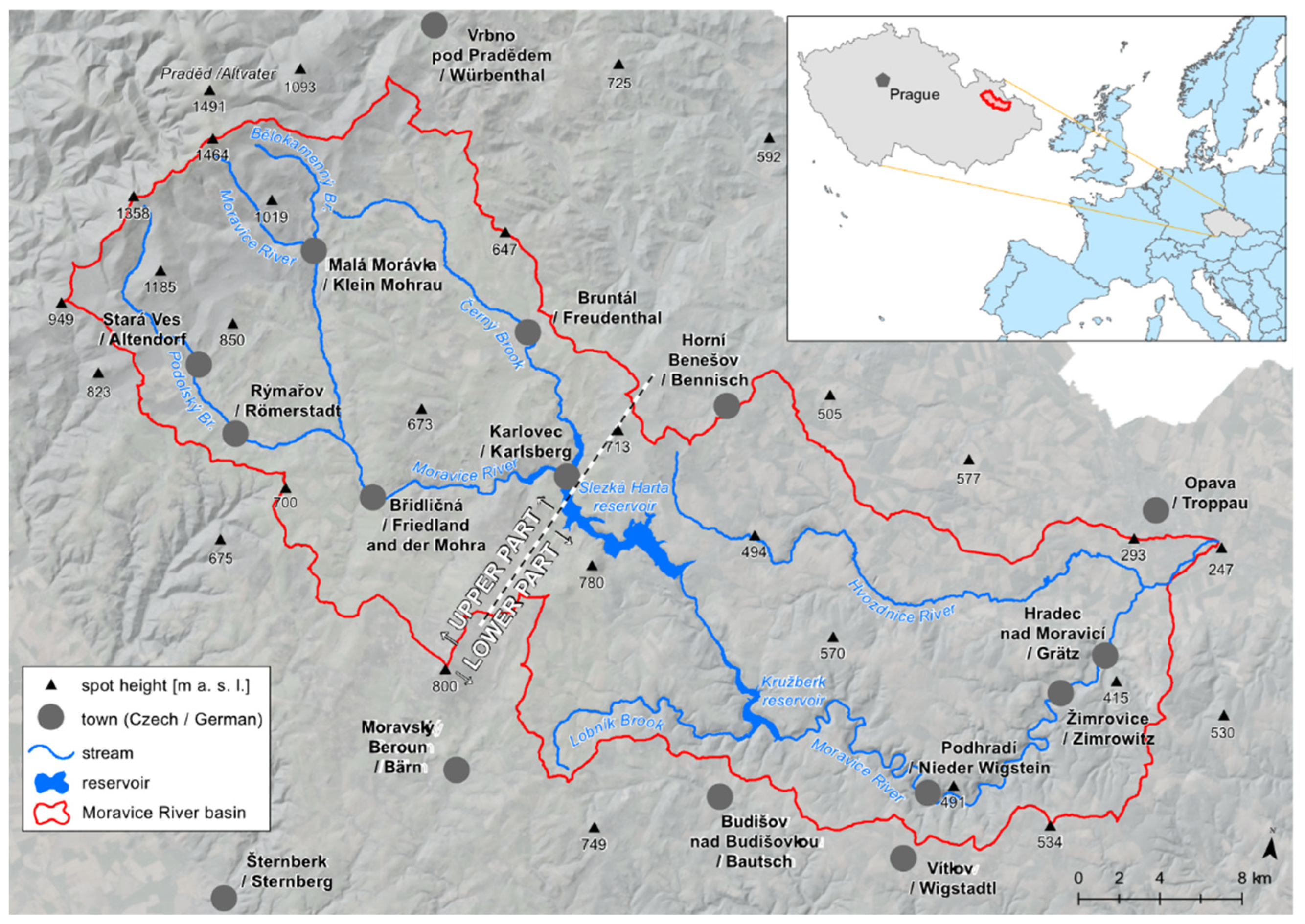
The Moravice river basin is located in the northeast of the Czech Republic and stretches predominantly in the west–east direction. The basin’s area equals 945 km2, and its main stream is the Moravice river, a waterway about 102 km long, whose springs are located in the Hrubý Jeseník Mountains at an altitude of 1150 m. The rugged mountainous relief in the western portion of the basin passes into a gently undulating plateau with the deep valley of the Moravice river. The lowest part of the basin, below the town of Hradec nad Moravicí, has a mainly hilly or lowland relief and a predominantly agricultural character. The watercourse empties into the Opava river, east of the town of Opava. The main tributaries of the Moravice river are the Podolský creek, the Černý creek, and the Hvozdnice river.
Due to the high runoff, the Moravice river and its tributaries have always been used for water management. From the perspective of using natural sources and land, the Moravice river basin can be divided into two segments, namely, the upper and the lower parts (Figure 1). In the upper portion, the largest settlement centers—Bruntál and Rýmařov—were established primarily in connection with the mining of precious metals and ore processing. At the beginning of the 19th century, ore mining experienced a decline, and the region switched to flax production. In contrast to the upper part of the basin, the lower segment was used predominantly for agriculture. In this area, the Moravice river has a relatively large longitudinal slope, resulting in significant hydropower potential, unlike other comparable streams in the Czech Republic.
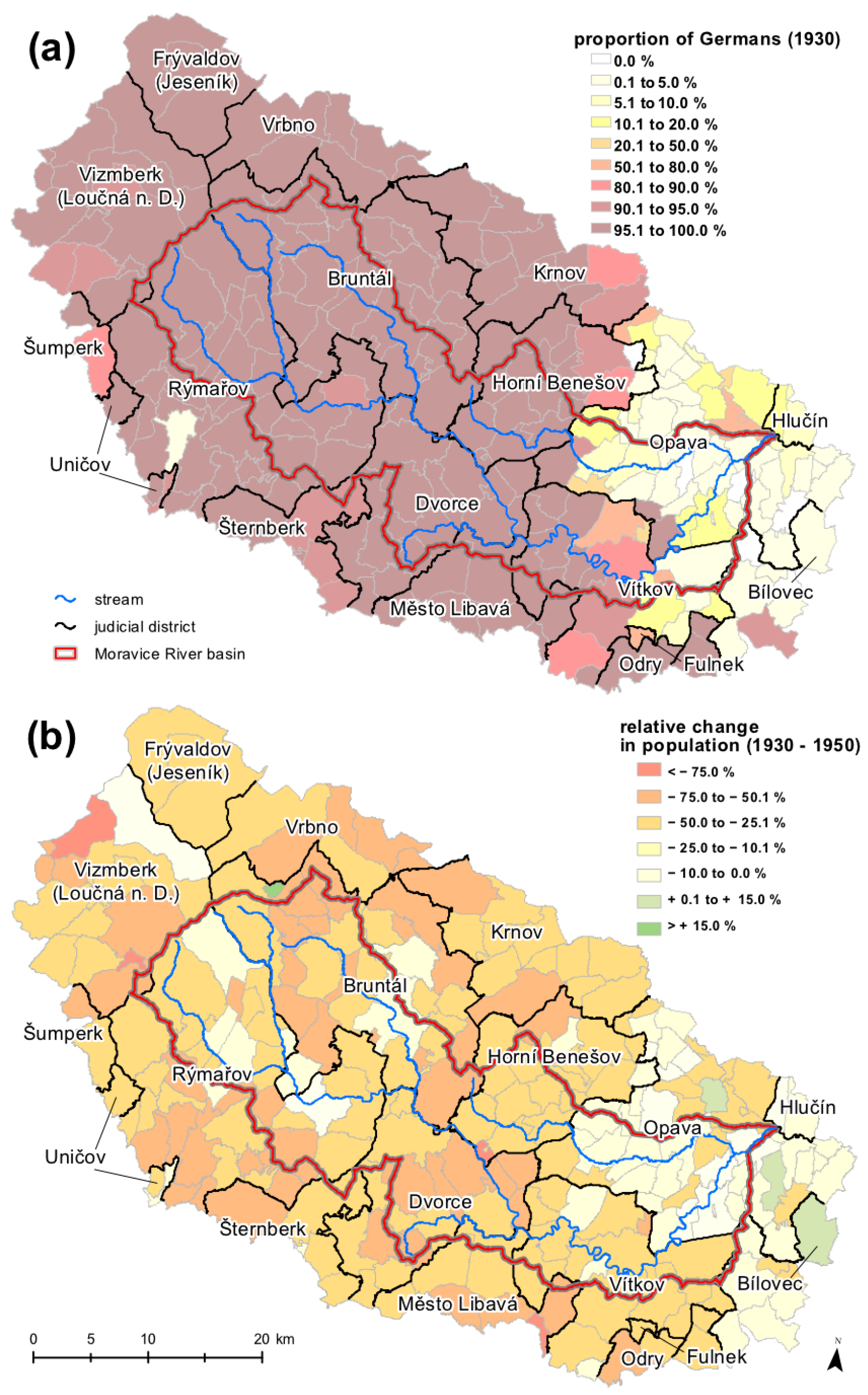
From the demographic point of view, the river basin embodies a less populated region. This is due to the specific geographical conditions and historical context. The basin is a part of the so-called Sudetenland, which had been inhabited mainly by the German population for centuries. This concerns mainly the regions around the towns of Rýmařov, Bruntál, and Vítkov. A much smaller proportion of Germans lived in the Opava region (Figure 2a). A demographic regression, already evident in the interwar period, was later exacerbated by the postwar events when the population often decreased by more than 20% compared with 1930 (Figure 2b). As a result of the expulsion of the German population after World War II, there occurred a fundamental and unprecedented change in the population number and structure [27]. The number of people of German nationality dropped conspicuously low, comprised virtually exclusively of persons with a declared antifascist attitude, people indispensable to the state (e.g., forestry experts), and mixed Czech–German marriages. The original German population was replaced with Czechs or Slovaks, often from the interior, or repatriates from abroad [28,29]. In the cases of Bruntál and Rýmařov, however, the rate of immediate replacement of the original population was around 45% and decreased further in the following years because of the departure of the settlers (Table 1). The total count in the region never returned to prewar levels, not even in connection with the enormous natural population increase during the 1970s and 1980s, which was a state-wide Czechoslovak demographic phenomenon. The concentration of manufacturing to large plants, in the spirit of the concept of an even distribution of industry, and the diversity of transport connections affected the population density. Industrial and traditional administrative centers with more diversified infrastructures grew, while the countryside remained sparsely populated. Some regions were even affected by emigration, which was related to the demise of small and medium-sized establishments, among other factors. The region can be characterized as a socioeconomic periphery [28,30,31].
3. Materials and Methods
3.1. Cartographic and Evidence Sources
Several cartographic sources and related registers were employed to identify the water-powered facilities: old topographic maps, old cadastral maps, the list of small water works from 1930, the State Water Management Plan of 1953, and a database of water mills in the Czech Republic. The characteristics of the cartographic sources are given in Table 2.
The rather poor positional accuracy of the 1st Austrian Military Survey maps stemmed from the insufficient cartographic methods and geodetic foundations with the transformation of the polynomial type [18]. However, these maps can be utilized in identifying point WPFs thanks to their continuity or continuity of other objects in their near vicinity (e.g., significant buildings such as churches). The search for specific localities on watercourses can be systematically specified according to the spacing of individual facilities on watercourses in connection with tributaries, raceways, or the road network. A similar procedure was followed in, e.g., the identification of river ferries in the Czech Republic [19].
To identify the WPFs, we analyzed the map keys of the old topographic maps and created a procedure for working in geographic information systems. The ArcGIS software, version 10.x, was employed to facilitate the analyses. The accuracy of the topographic maps (Table 2) is based on experience with georeferencing old cartographic sources from Central Europe, namely, the Austro–Hungarian empire [17,18], and georeferencing maps from 1876, 1955–1956, 1986–1987, and 1995–1996. Maps of the stable cadastre at a more detailed scale were used predominantly for refining the localization of the WPFs in the maps from the 19th century. Based on the experience with the accuracy, the WPFs were first identified on the 3rd Austrian military survey maps, and their database was created. We then compared the facilities with maps from the previous periods (1763–1768 and 1837–1840) and incorporated any and all additional WPFs in the database. The database contains the type of facility, its functionality in the individual mapped periods, name, location according to cadaster, and use at present. There is also a relation to two separate historical databases of WMSs from 1930 and 1953.
The database from 1930 [32] constitutes the first comprehensive list of water-powered facilities in what is now the Czech Republic. This register, produced by the Ministry of Finance for tax purposes, contains the name of the watercourse, address of the facility, information about the operator or owner, type, flow, and power of the facility, number and type of the water drive, and raceway-related information. The information is registered according to the territorial jurisdiction of the district financial directorates. The database from 1953 [33] contains similar data, as it embodied a part of the comprehensive state water management plan of Czechoslovakia, published by the Water management development and investment center in Brno. The information was published according to the most important river basins or parts thereof.
When interpreting the results based on the old topographic maps, we have to take into account the limitations inherent in these documents [34,35]. These deficiencies include the spatial accuracy, ambiguity of the drawn object, and inferior readability of the map due to its age, storage conditions, and manipulation. A reasonable degree of spatial accuracy can be achieved via backward editing, where the most recent and, therefore, the most spatially accurate map serves as a source for the older maps [36]. The ambiguity of the drawn object and worsened readability are more serious problems, especially in connection with WPFs and their types. A substantial number of WPFs were thus either assigned only a pictogram for a waterwheel without a closer specification or given the pictogram was hard to read.
3.2. Archive Sources
To describe the development of the facilities, we used primarily archival sources. The main sources were embodied in the fonds of the Provincial Archive in Opava (the fonds of large estates in particular) and in the fonds of the State District Archives in Bruntál and Opava (including, in particular, the fonds of the district authorities, together with those of the local and district national committees). Additional sources comprised, for instance, water books on the individual facilities, municipality chronicles, and estate funds. Cadastres from the Moravian Provincial Archive in Brno were used too. To place the history of the study area into a wider context, we investigated expert literature, focusing on the economic development of Czechoslovakia (especially in the modern era), the expulsion of the German population, and the fates of the border areas after 1945. We also utilized regional literature and specialized studies in relevant scientific journals. The statistical data were provided by topographic maps and population surveys (the 1930 and 1950 censuses in particular).
4. Results and Discussion
4.1. Water-Powered Facilities Recorded on Old Topographic Maps
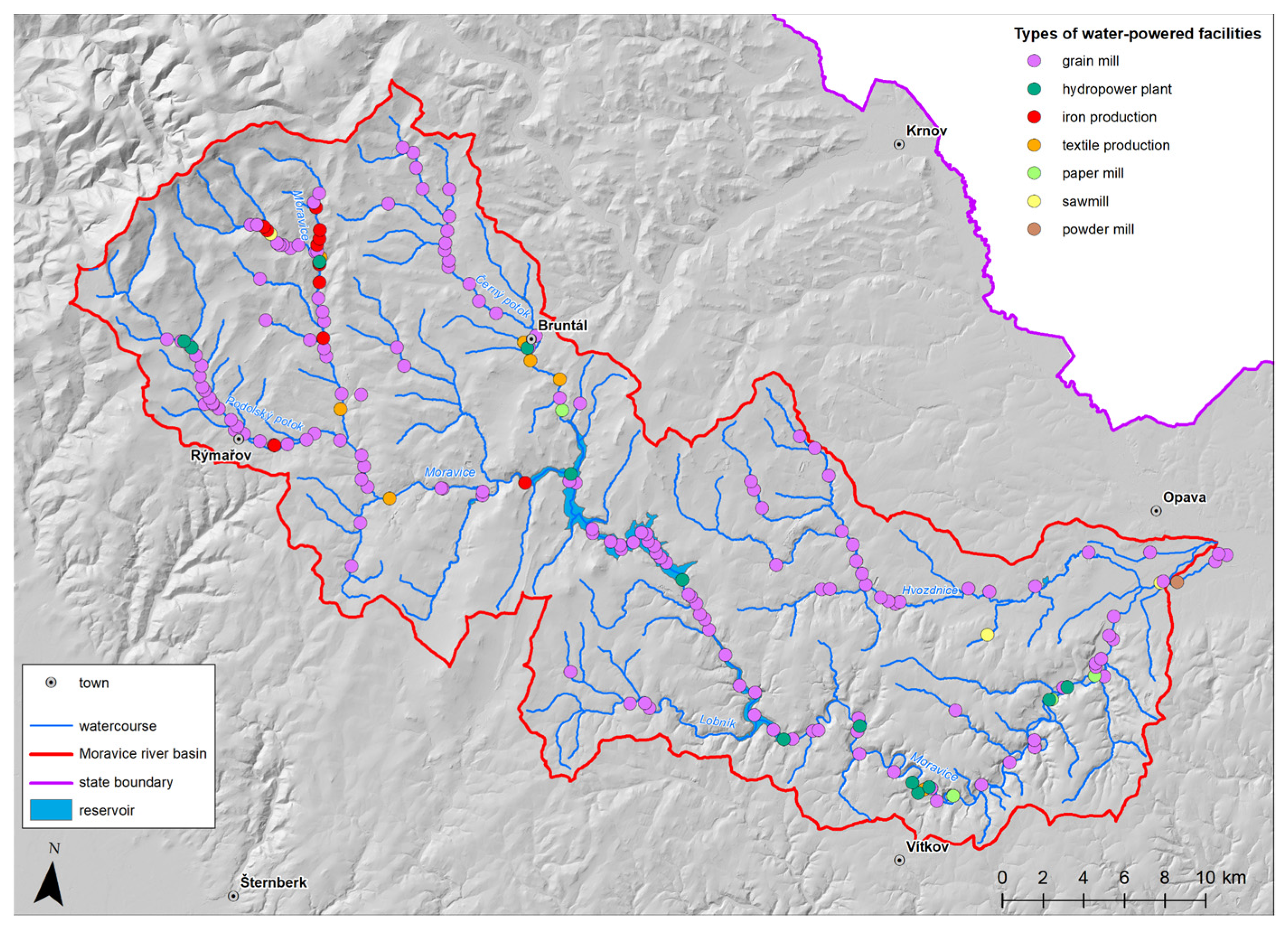
In total, 194 WPFs were recorded on the old topographic maps. Generally, maps from the 18th and the 19th centuries contained more of the WPFs than the 20th century ones, with the majority of the recorded WPFs (155) found in the period of 1837–1840. The distribution of WPFs in the upper, middle, and lower parts of the study area was more or less balanced, with fluctuations in the individual periods.
The results from the old topographic maps exhibit the main trends in the development of the number and typology of the WPFs in the study area (Table 3). The peak in the number of the WPFs recorded in the mid-19th century had most likely been caused by the agricultural revolution at the end of the 18th and the beginning of the 19th centuries [34]. A slight decline at the end of the 19th century was caused by the concentration of many WPFs into larger industrial units. The relatively stable number and structure of the WPFs were significantly interrupted after 1945, as is reflected in the maps from 1955–1956. Concerning the types of WPFs, grain mills dominated in all of the researched periods. Iron processing facilities, wire mills, in particular, were also common (Figure 3). Small hydropower plants (13 facilities) were captured for the first time on the 1955–1956 topographic maps. The paper mills in the upper part and the textile production facilities in the lower portion of the study area had ceased to exist. Further, the number of grain mills and iron production facilities had declined steeply, but this was compensated to some extent by their conversion to hydropower plants. At present, only hydropower plants use water as their propulsion medium, and other WPFs do not exist.
Due to the problems associated with the old maps (see Section 3.1), a substantial quantity of the identified WPFs were assigned the general category of grain mill, leading to a probable overestimation of their number. On the other hand, the dominance of grain mills was also recorded in those historical databases that provide more detailed information about the individual WPFs (see Section 4.2), giving some validity to the results from the topographic maps.
4.2. Water-Powered Facilities Recorded in the Historical Databases from 1930 and 1953
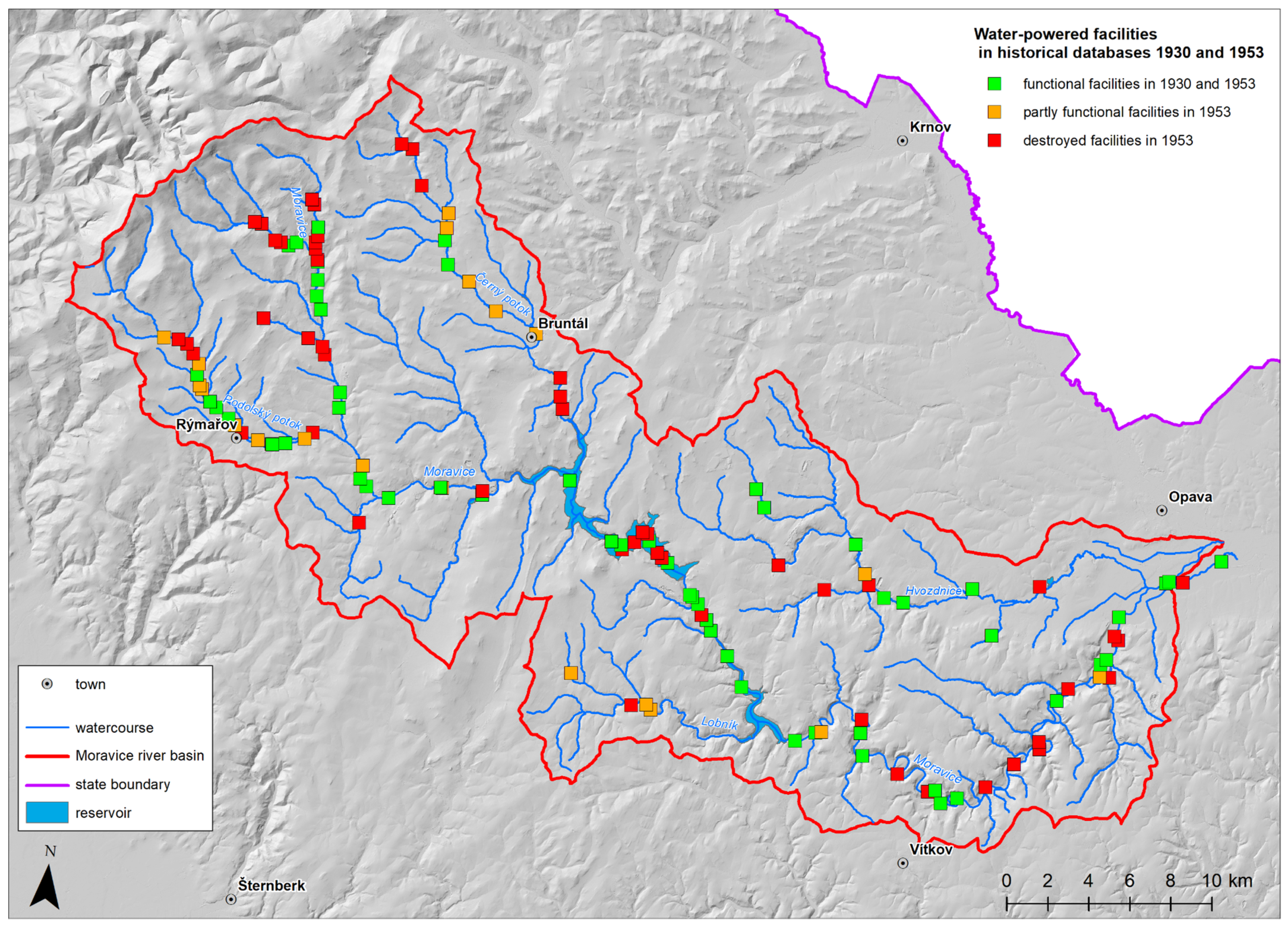
The historical database from 1930 recorded 144 WPFs in the study area, while 1953 one recorded 83 WPFs. Grain mills dominated, in agreement with the trends regarding the types of WPFs recorded on the topographic maps. Unlike the topographic maps, both databases incorporated more than one type for each facility and (in the case of the 1953 database) also conveyed whether the waterpower source was functional or not and whether the facility was in operation. Therefore, out of the 83 WPFs, only 60 had remained fully functional in 1953. This fact was most likely reflected in the 1955–1956 topographic maps, where only 45 WPFs were recorded. The destroyed or only partly functional facilities were situated mostly in the upper part of the study area (Figure 4). The fully functional WPFs could be found on the Moravice river and its more significant tributaries that exhibited a higher concentration of these WPFs. The findings reflect the socioeconomic changes that occurred after 1945 and are described in detail within Section 4.5.
The unique information obtained from the historical databases concerned not only the state of the functionality of the recorded WPFs but also their types and information about the water engine. In 1930, 21 facilities combined 2 functions, and 3 facilities combined three functions (e.g., grain mill, hydropower plant, and sawmill). In 1953, a combination of two functions was recorded in 11 facilities, and a combination of three functions in 1 facility. In relative terms, there was a decrease in the number of multitype WPFs (17% of the WPFs in 1930 and 14% in 1953), pointing to a simplification and specialization of the WPFs and a production concentration into larger units.
Regarding the water engines, 168 were functional in 1930, and their number dropped to 106 in 1953. While in 1930, overshot waterwheels dominated (81), in 1953, only 26 items of this type remained. Further, the number of breast and undershot waterwheels had declined. Francis turbines dominated, and their number increased from 54 in 1930 to 62 in 1953. The number of plants with specific engine types includes plants with a combination of several engines, e.g., a plant with a breastshot waterwheel and a Francis turbine. The total number of plants, therefore, includes a combination of 147 plants in 144 WPFs in 1930 and 94 plants in 83 WPFs in 1953. In both periods, using a combination of two identical engines was typical. While in 1930, the engine type was represented by two overshot waterwheels, in 1953, Francis turbines had come to dominate. Thus, the more efficient technology prevailed. Regarding the power capacity, the water engines installed in 1930 generated 4235 kW, while those installed in 1953 generated 4154 kW, despite their smaller number. This shows that a more efficient technology was used in 1953. By contrast, 23 hydropower plants running in 2021 produced 5852 kW.
4.3. Hydropower Plants in 1930–2021
Waterwheels had traditionally been employed to drive production facilities. Towards the end of the 19th century, more efficient water turbines began gradually to supplement and replace the wheels. Both waterwheels and turbines started to be employed for electricity generation from the beginning of the 20th century. A comprehensive overview of hydropower plants in the area of interest (Figure 5 and Table 4) was compiled using the 1930 and 1953 state databases and the current list of licenses provided by the Energy Regulatory Office. There is no sufficient evidence for the second half of the 20th century; however, the existence of hydropower plants could be derived from the topographic maps from 1986–1987 and 1995–1996.
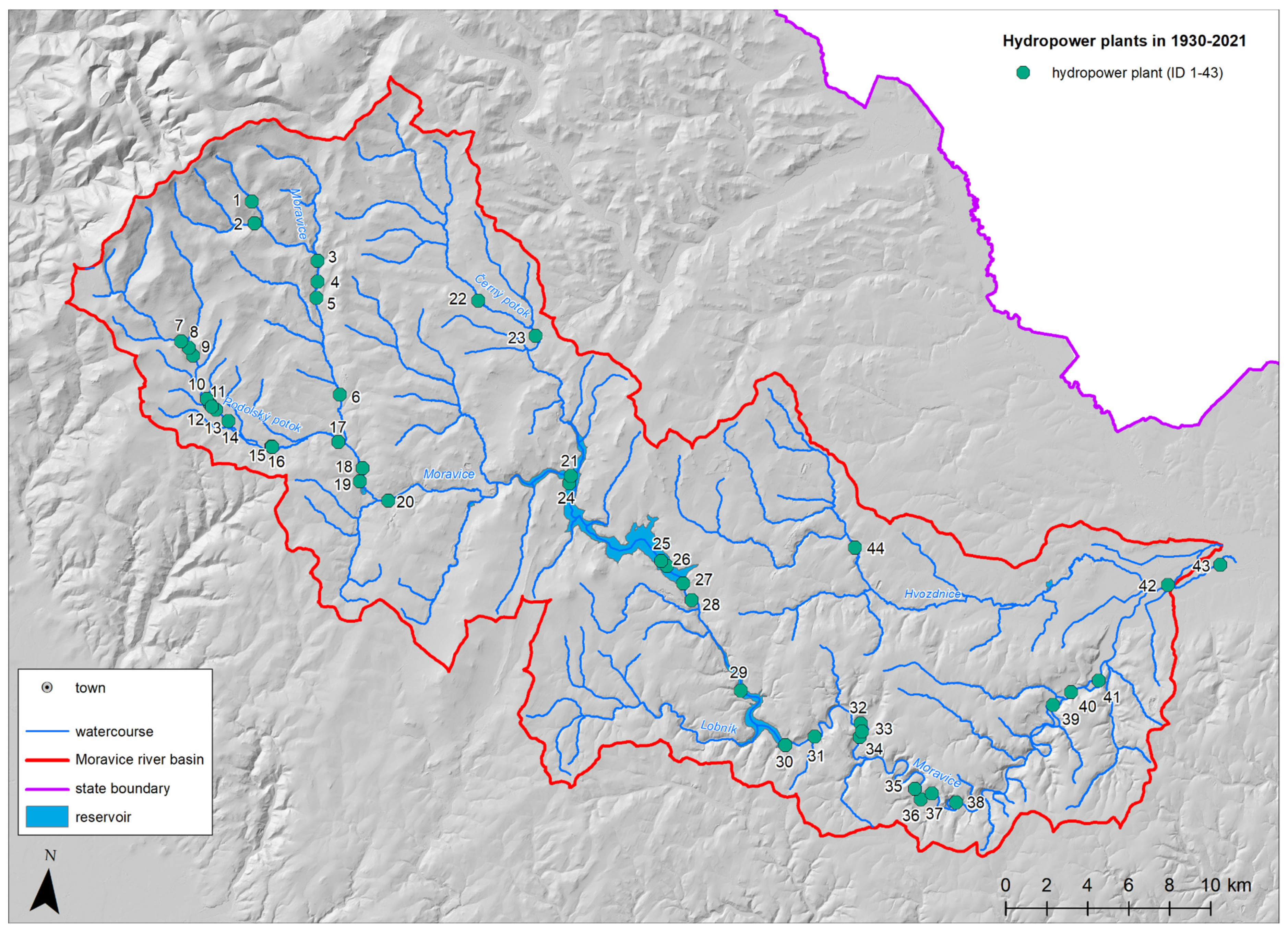
The continuity of hydropower plants is expressed in Table 4. In total, 33 hydropower plants existed in 1930, with 2 out of order. With the exception of 3, all plants were established in already running WPFs, and 11 were propelled by waterwheels. Due to the postwar events, some of the plants stopped functioning, and by 1953 only 25 plants existed (of which 1 was nonfunctioning). The number of waterwheels had dropped to six. A more significant decline in electricity generation during the postwar period was caused by changes in the population and economy and also by connecting settlements to the central distribution network (see Section 4.5). The decline in the number of hydropower plants continued in the later period. The only exception was the Lhotka power plant (put into operation in 1960), built on a pressure pipeline connecting the Kružberk reservoir with the water treatment plant in Vítkov-Podhradí. In 1986–1987, only nine hydropower plants were represented in the topographic map in the Moravice river basin. Nevertheless, because of the growing demand for electricity in the second half of the 1980s [15], old hydropower plants started to be restored, usually along with the corresponding water management infrastructure (weirs, raceways). In this context, it must be acknowledged that the actual number of hydropower plants in 1995–1996 was probably higher than that (ten) shown in the corresponding topographic map. At present, 23 hydropower plants are operating in the study area. Most of these were built through restoration at places with a history of hydropower use; only four were constructed at locations with no WPF history.
4.4. The (dis)Continuity of Water-Powered Facilities between 1763 and 2021
The continuity of the operation of the individual WPFs was assessed according to their presence in all researched sources, i.e., five topographic maps and two state registers. Out of the 194 WPFs, only four existed through all the study periods. In the past, they were operated as grain mills and later changed their function to become paper mills or machine works. In addition to these, there are 18 facilities whose operation had been interrupted in the past but was eventually restored; these WPFs thus follow the historical use of hydropower. Including one hydroelectric plant that was established in the latest period, there are only 23 WPFs (all serving as hydropower plants) operated in the Moravice river basin; this then illustrates the massive reduction of WPFs in the region.
The most significant drop in the quantity of the WPFs appeared between the 1930s and the 1950s (41 facilities) and, subsequently, after the 1950s (69 facilities). Often, these facilities had a long history that was disrupted by the impacts of WWII, namely, the aforementioned expulsion of German inhabitants and the emergence of a socialist economy that concentrated the production into larger facilities, making many smaller ones shut down. These facilities assumed different functions over time or had combined functions. In addition, some of the facilities existed only for a shorter period of time and were never reopened. The demise of these enterprises was linked to normal location aspects and a competitive environment, mainly in the upper part of the basin.
4.5. Societal and Economic Changes Affecting Water-Powered Facilities
The changes after 1945, reflected in the number and structure of the WPFs, had a broader socioeconomic dimension. The study area is situated in a region (Sudetenland) that was strongly affected by the expulsion of the German population after World War II. Before the war, the local Germans owned a majority of the production facilities. These facilities were then confiscated after 1945. The newcomers, however, lacked a mental connection with the region and often also the knowledge and predispositions to continue the local production. The knowledge of the historical context of (not only) the water-powered facilities before the mid-20th century, therefore, disappeared from the collective memory. The different socioeconomic structure of the population and its steep decline resulted in a massive production discontinuity. Another change in the ownership structure occurred after the communist coup of 1948 when the facilities were nationalized. The new state economic policy did not reflect the production continuity, leading to radical changes in the economy of the region during the second half of the 20th century. The production underwent reorganization and restructuralization, during which a part of the production facilities was closed due to redundancy and unprofitability (namely, owing to a lack of employees and interest in working in industrial sectors). This concerned mainly solitary facilities with difficult accessibility or a high war damage rate. Unused facilities—both buildings and machinery—fell into disrepair, and in the 1950s, their revitalization was no longer profitable; thus, a substantial portion of them were demolished. In some cases, a whole industry sector was abandoned, and the related village became a popular tourist center throughout the year. A part of the production was then moved to the hinterland or Slovakia within the new state economic policy [28]. The companies that continued operating were usually more efficient facilities with high-quality transport connections, and they provided for state-organized employment in the investigated area. The preferred production facilities concentrated in, among other locations, the larger towns (Bruntál, Rýmařov, Břidličná or the Opava agglomeration). These localities had also been resettled, with the exception of the Opava region, where the population structure and count did not change much due to the prevalent non-German population (Figure 2). The concentration of production since the early 1970s was also deepened by the state concept of spatial development, i.e., the so-called central system, abandoned in the 1990s. The production decline in this region was also related to the increased recreational potential (primarily for the population of the nearby Ostrava industrial agglomeration) and the strengthened protection of the local landscape (designation of a Protected Landscape Area in 1969).
Besides the fundamental societal and macroeconomic changes, a natural decline of the WPFs has occurred since the end of the 19th century due to replacing waterpower with modern power sources (oil, electricity). The onset of electricity was associated with processes such as transforming some of the WPFs (grain mills in particular) to small hydropower plants that incorporated a system of water turbines. Electricity was used for the mechanical propulsion of factories or their lighting. Later, the hydropower plants became local energy sources for the surrounding areas. The connection of settlements to the central energy network led to a gradual reduction in the count of functional waterpower plants. The attitude of large state companies, which refused to use local, small electricity producers [15], and the state support of large hydropower plants, played a significant role in this trend. Many of the WPFs were also destroyed during the construction of two important water reservoirs, namely, Kružberk (built 1948–1955) and Slezská Harta (1987–1997). The decline of the small hydropower plants ended with the waning 1970s and the turn of the 1980s (see Section 4.3).
4.6. Examples of Water-Powered Facilities and Their History
Despite the turbulent socioeconomic changes that affected the region after 1945, there are a lot of WPFs with a tradition of over a hundred years. Some changed their field of activity because of the ownership transfer or the economic and societal demand (a typical change was grain mill—sawmill, tilt hammer—small hydropower plant), while others showed long-term stability in preserving one particular type of production. Such stability was nevertheless typical, above all, of large facilities with high economic potential. By contrast, medium-sized and small facilities changed their production or even ceased to exist in the postwar period because of a lack of trained staff and a fundamental transformation of the state’s economic strategy (see Section 2). Consequently, it is possible to find facilities with different types of development, including those whose operation with a water-management function has never been interrupted.
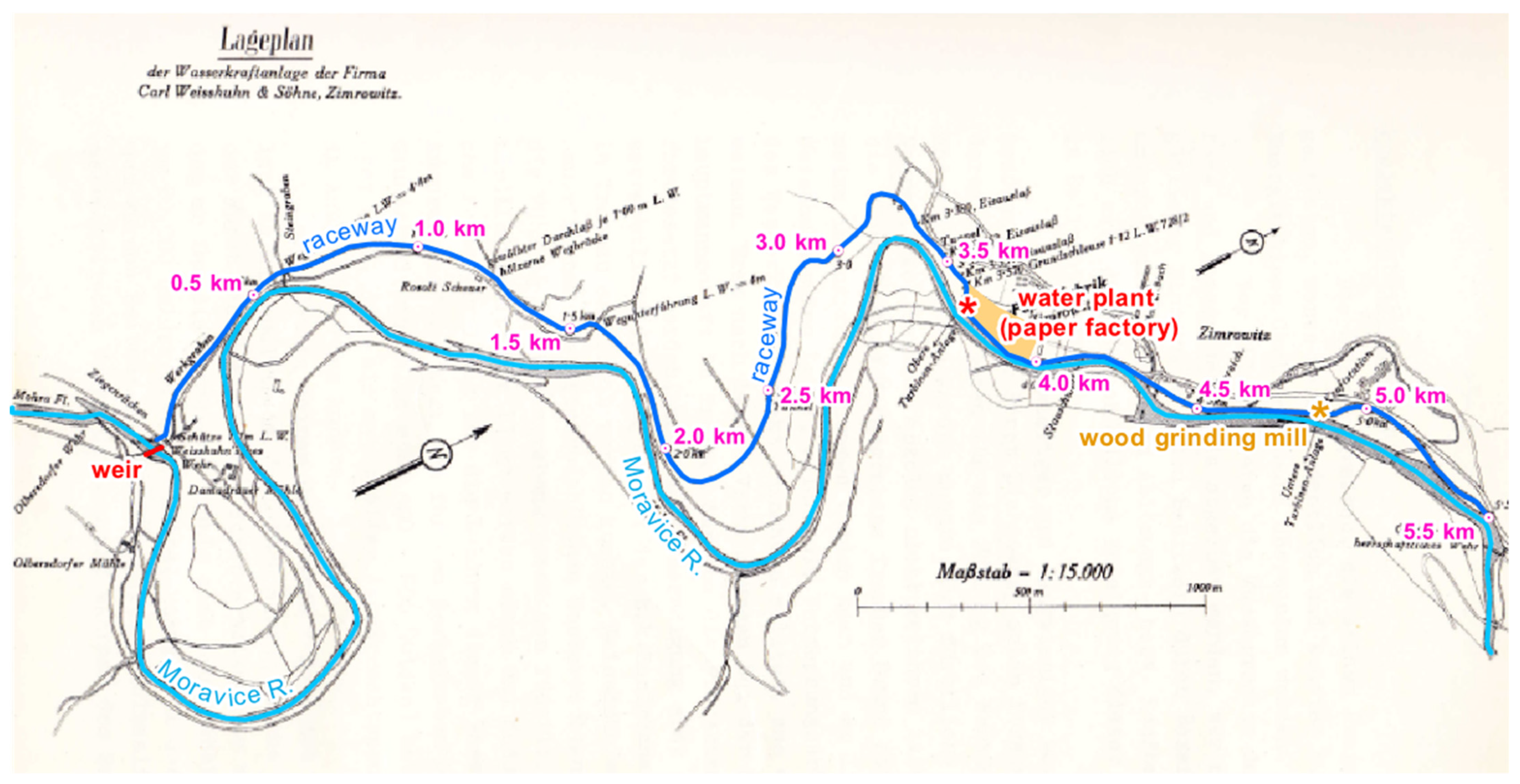
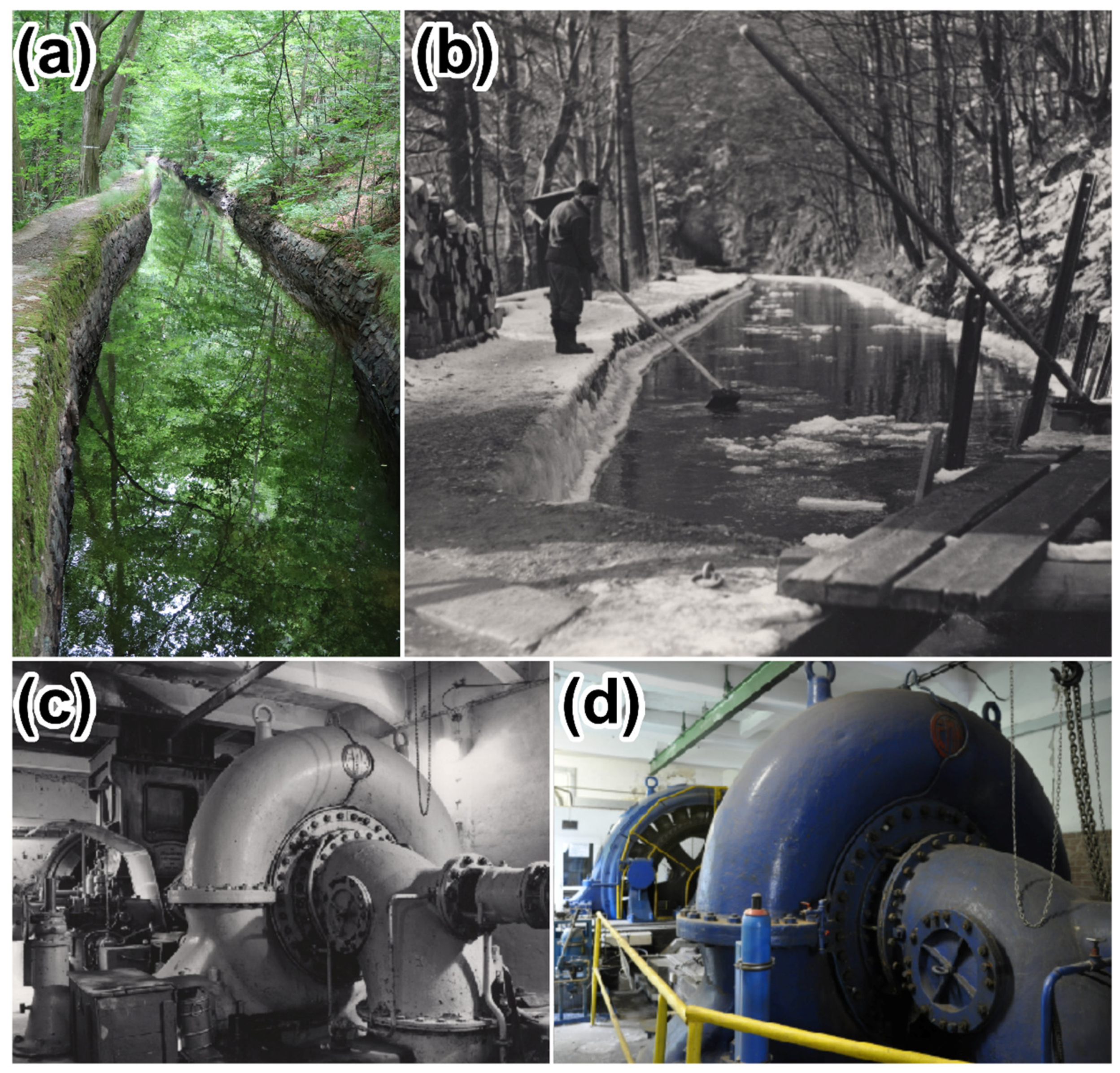
An example of a plant that has retained its function and manufacturing tradition until the present is the paper factory in Žimrovice. This WPF came into being in 1891 and very soon ranked among the efficient Austrian (Czech) Silesia-based paper manufacturers, such as those established in Krnov, Opava, and Hradec nad Moravicí, that were converted from grain mills to paper mills [37]. To promote the energy self-sufficiency and overall economy of the company, a unique, 5.5 km long raceway with tunnels and aqueducts was built (Figure 6). The upper part of the raceway brought water for technical and energy generation purposes and allowed wood transportation (Figure 7). The lower portion was shortly employed to support woodwork; after that, however, its role shifted to solely generating electricity in the paper mill. Girard turbines, later substituted with Francis turbines, were utilized to power the machines. The premises were comprised of two hydropower plants: one directly in the main part of the industrial zone the other on the lower raceway. The plants initially powered smaller machines and provided lighting and then also ensured overall electrification of the premises. After being connected to the central distribution network, the paper mill began to be capable of supplying the generated electricity to Opava in the event of a surplus or a shutdown. The lower hydropower plant existed until 1957, whereas the upper one has survived to this day to support the production. In 1945, the mill became part of a large national company consisting of several originally independent constituents. The mill is currently owned by a large multinational company [38,39].
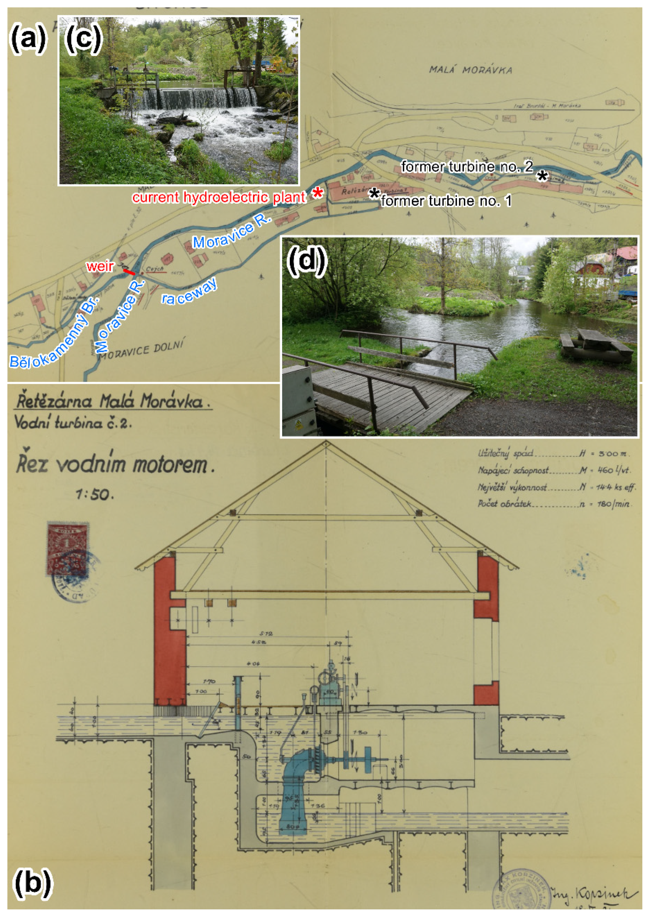
Another facility that has maintained its manufacturing importance rests in the Malá Morávka ironworks. The wider area of the village embodies one of the largest iron ore districts in northern Moravia, active as early as the 16th century. The blast furnaces are traced to 1618, thus being among the oldest of their kind in the Czech lands [39]. In the mid-19th century, the ironworks consisted of a chain sawmill, a sawmill, and a grinding mill. Later, a wire and nail factory completed the set. At the beginning of the 20th century, the three waterwheels were replaced with an 85 horsepower (hp) spiral turbine in the wire factory. Similarly, a 14.4 hp turbine that substituted one of the waterwheels found use also in the chain factory (Figure 8). The highest production rate and count of employees were reached in the 1930s. The iron processing plant remained operative even after 1945, turning into a subsidiary that changed affiliation several times. The manufacturing of chains was terminated in 1967, and the new program focused on components for the automotive industry; iron production, however, has been preserved and continues till the present day [40,41,42,43]. A modern hydropower station near the ironworks was built after 2000. The water is supplied through a 400 m long raceway, which follows the original—albeit shortened—track. The electricity to enter the public grid is generated by three turbines with a total output of 49 kW.
In the investigated area, similarly to other regions of the Czech lands, the key energy companies were nationalized. This concerned, above all, the power plants and distribution infrastructure. During 1945–1946, the state took over the municipal power plants in, for instance, Bruntál, Rýmařov, and Horní Benešov. The ownership status then changed accordingly also in the private (corporate) power plants, such as those of Karlov, Velká Štáhl, or Janušov. Organizationally, these works all merged into the newly established national energy company [28].
The hydropower plant in the village of Karlovec exemplifies a nationalized energy company and, at the same time, illustrates the postwar chaos. The station was functional already in the interwar period. In 1934, the waterwheels were substituted with a Francis turbine having an output of 35 hp and a slope of about 4.3 m. The water coming to the facility had previously powered a sawmill. The produced electricity served the villagers for operating purposes during the day and enabled lighting during the night. In 1946, the plant was confiscated (the owner had been of German origin); however, only the electricity production was nationalized. The facility became part of an electricity company that was not interested in running the plant, putting it out of use in 1949. The village authority took an interest in supporting the connected sawmill, which would use the hydropower plant; however, due to the confiscation-related confusion (potential return of the original owners) and the unfeasibility of private business after 1948, the intention did not materialize. Despite the local government appealing to the authorities, the entire hydropower facility eventually deteriorated to be demolished in the mid-1950s [41]. The village, moreover, had to give way to the Slezská Harta reservoir, a project completed in the 1990s.
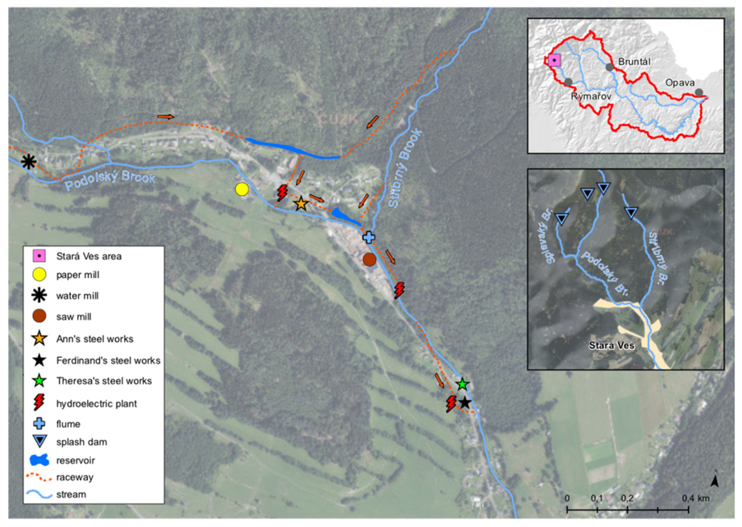
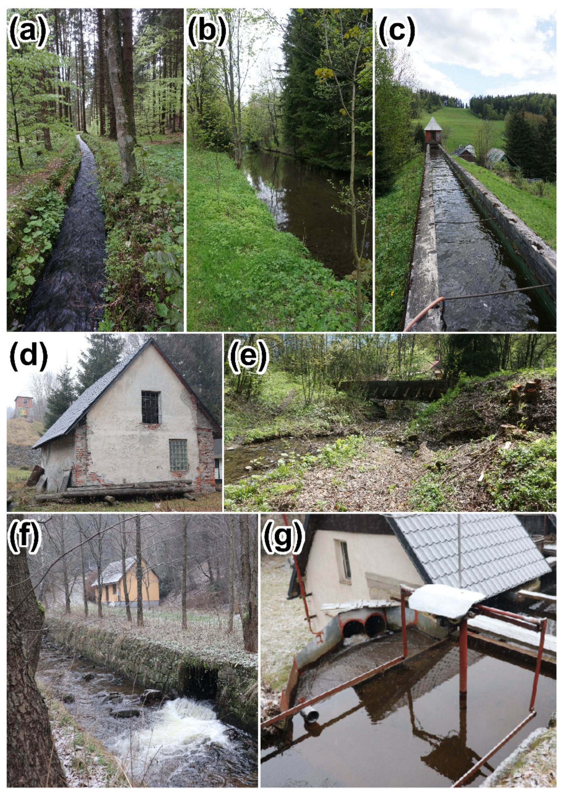
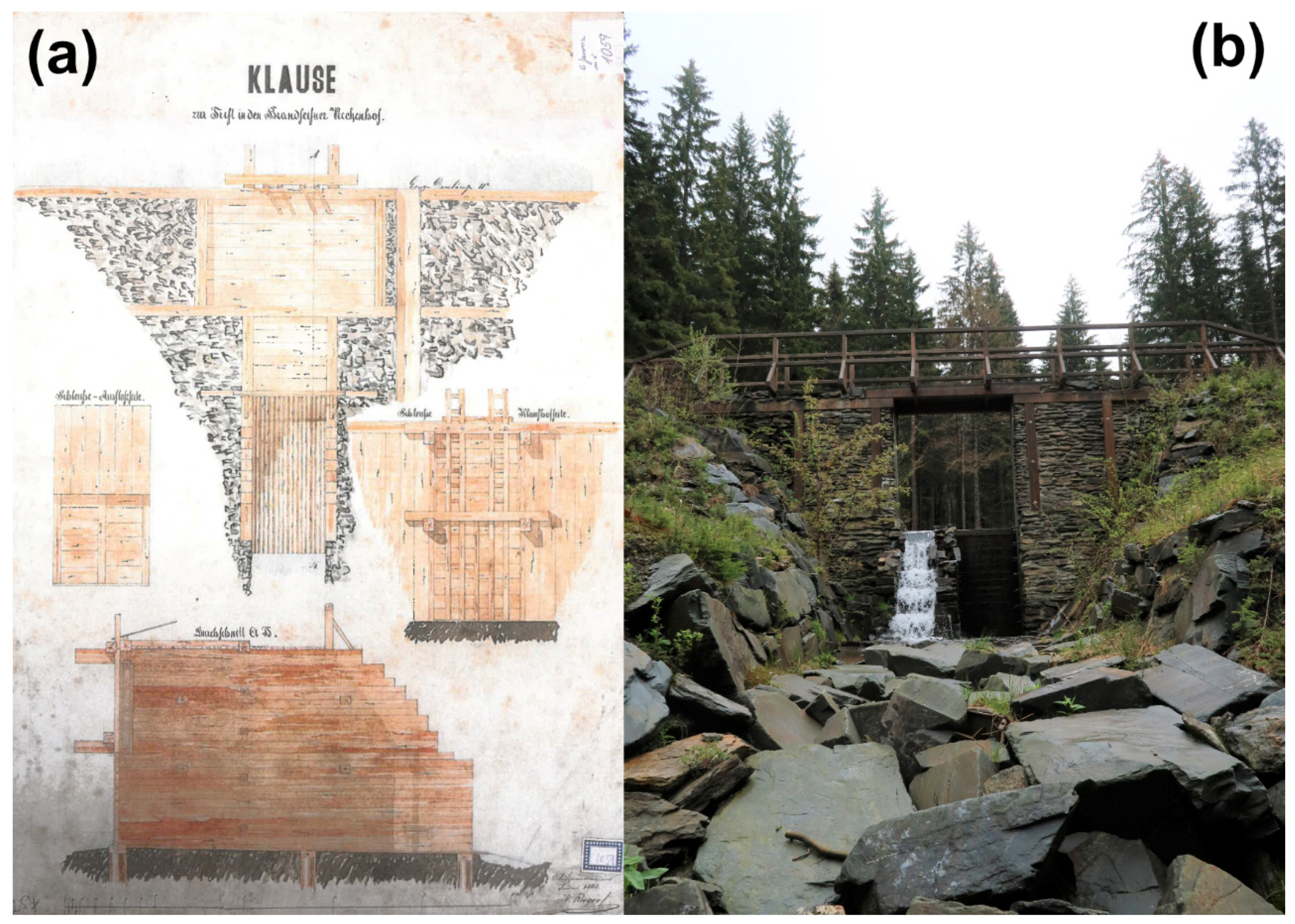
A locality with multiple hydropower facilities scattered across is a part of village area of Stará Ves at the confluence of Podolský and Stříbrný creeks. Although largely abandoned in the later periods, Stará Ves had long profited from the hydrological mode of both creeks and the rich sources of minerals (iron in particular), hosting many WPFs that were established to support the iron processing and woodworking sectors. The oldest facility rested in the currently defunct paper mill, built together with a raceway in 1682. The mill’s productivity reached a peak during the 18th century, only to fall through a steady decline by the mid-19th century. At that time, a new steelworks was built, locally referred to as Anna’s steel mill (Figure 9 and Figure 10). Due to a markedly increased demand for waterpower, a prolate reservoir—existing to this day—was constructed to receive water from Podolský creek (via an approximately 700 m long underground raceway) and Stříbrný creek (by an open raceway). The water from the reservoir then flew along a trough to reach the inlet, from which it was conducted through an underground feeder towards the propulsion unit. A gradient of several meters allowed operating the steelworks (rolling mill) and the adjoining production units. Currently, these channels supply a small hydropower plant restored in 1956. The wastewater was discharged via an underground tunnel into another reservoir, one near the confluence of the creeks. The pond enabled the users to enhance the discharge in a stream powering a sawmill. Such a system of reservoirs and raceways, albeit designed gradually, embodied an inovative project that led to a strengthening of the water flow in the individual raceways, an effect achieved with bridging trunks. The steelworks were originally powered by waterwheels, later substituted with a 150 hp Francis turbine. The works closed down after the war and were demolished. The sawmill first employed a waterwheel, integrated a portable engine in 1872, and finally accommodated a Francis turbine in 1923. The mill has remained operative to this day and is supplied by a small, modern hydropower plant. Other water-powered facilities in Stará huť included Tereza’s steelworks (initially a wire and a stamping mills, later also ironworks and fittings), running a Girad turbine since 1887, and Ferdinand’s steelworks (whose constituents comprised, among others, a wire mill and, later, a chain mill), powered by a Francis turbine. The postwar histories of these works remain effectively unknown [41,42]. The WPF in the village of Stará Ves needed utility wood to function; therefore, several reservoirs (splash dams) were built in the upper reaches of Podolský creeks and its tributaries to deliver such wood to the WPF. One of these water areas was restored to its original character in 2014 (Figure 11); other splash dams, however, progressively disappeared and can be only partly identified in the present-day landscape. The old creek beds were modified to support wood rafting, but due to them not being used in this manner for a long time, there are no traces of the modifications anymore [41].
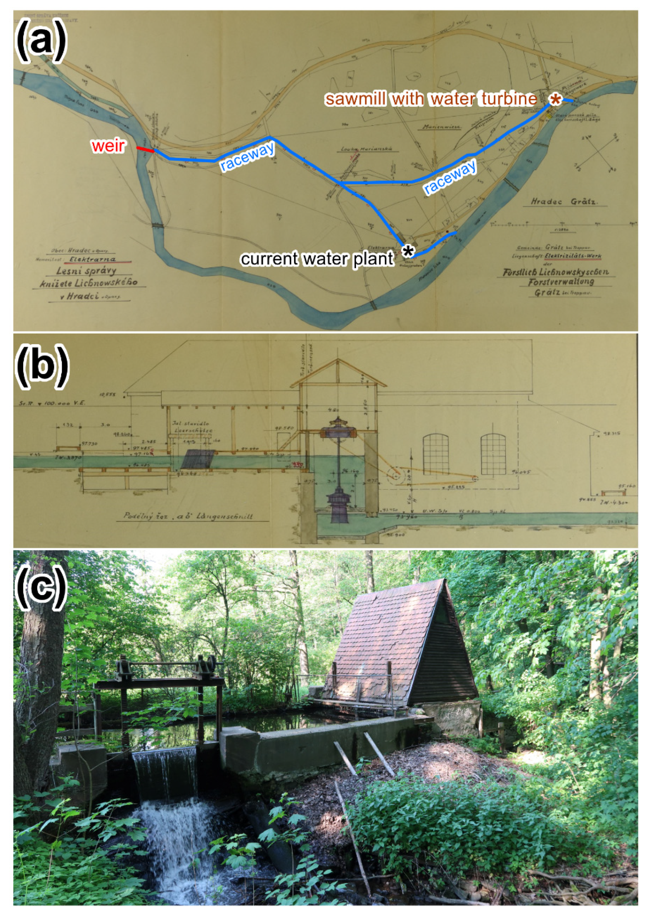
After 1989, in connection with another major social and economic shift, many facilities or premises were restored. Small hydropower plants, such as that in Hradec nad Moravicí, illustrate the process. The plant named herein is situated in an area where a sawmill and a paper mill were established already in the mid-18th century. A textile-spinning mill was added to the set in 1827. The water was delivered from the Moravice river via a forked, 857 m long raceway. One of the branches led to the sawmill, while the other ended at the paper mill. The water from the raceway also irrigated the surrounding meadows. In 1912, a hydropower plant was launched within the paper mill, employing a Francis turbine that had been installed in 1909. Expanding the plant caused the mill’s productivity to decrease. The hydropower station was then modernized several times (1922, 1935); during the second overhaul, the original turbine was replaced with a Kaplan one. The plant supplied electricity to households and businesses and provided lightning until 1949 when it ceased operating. The initial raceway nevertheless continued to service the local chateau, watering its gardens and meadows; the paper mill, restored in the 1950s (and still operating); and, later, the public swimming pool [41]. The hydropower plant was restored in 1985 at its previous location (handling regulations, 2014) (Figure 12); presently, it is supplied through an 850 m long raceway and utilizes two turbines with a total output of 10 kW.
4.7. Discussion
The Moravice river basin was selected for the analysis because it constitutes a region with a centuries-old manufacturing tradition in which water played a central role as a dominant energy source. At the same time, the basin can be considered a region where the production continuity was fundamentally disrupted in the middle of the 20th century. The study area is located in the Sudetenland, a part of the Czech lands (Czechoslovakia, later the Czech Republic) and Poland; the province is mostly hilly, encompassing foothills and mountains. These predispositions then determined the livelihood of the local people: textile, glass, and iron processing dominated, together with the well-developed mining of various ores. From the perspective of agriculture, flax and fodder cultivation was the focus, with grain becoming a complementary activity [44]. The study area differed from other parts of the Czech lands not only in the preferred production segments but also in the ethnic composition: the borderland, where the Moravice river basin is situated, was populated predominantly by Germans.
The target region exhibits a high concentration of water-powered facilities. For centuries, water was the only source of energy for the grain mills, tilt hammers, paper mills, and ironworks. The transition to modern energy sources, i.e., steam and electricity, occurred in the second half of the 19th and at the beginning of the 20th centuries [45,46]. This trend arose from technological advancement and developed across not only the study area and other parts of the Sudetenland but also the Czech lands in general and, in the broader context, Central and Western Europe [47,48,49,50]. Concurrently, the waterwheel was replaced with more powerful turbines of various types [46].
The natural evolution and manufacturing traditions of the study area were interrupted in the mid-20th century through the abovementioned social and economic changes (see Section 4.5). In this connection, two factors had a major impact: 1. the nearly complete expulsion of the German population, and 2. the radical transformation of property ownership, associated with the nationalization of all large-scale and later also small-scale enterprises. While the nationalization was a nationwide process, the expulsion affected the border regions or large hinterland cities (such as Brno and Olomouc) in particular. In this respect, the fates of the study area, the Sudetenland, differed significantly from the interior of Bohemia and Moravia. The expulsion of the Germans had a pronounced effect in terms of production discontinuity. Similar factors with comparable impacts on the development of WPFs were also identified in the neighboring countries, namely, Poland [46] and Slovakia [51].
Property ownership-related transitions took place throughout the Eastern bloc but were not uniform, involving fundamental differences. The study area is a part of the former Czechoslovakia, which at the time embodied the most industrialized country in Central Europe. This distinguishes its development from the less advanced Eastern European nations, such as Hungary or Romania [25]. Thus, the nationalization-induced changes in Czechoslovakia proved more severe than those executed farther to the east. Moreover, adjacent Poland, Hungary, and East Germany followed less straightforward paths, making the deprivatization markedly less strict; small craft trade licenses and minor agricultural enterprises were allowed to continue through the socialist era [52]. In terms of the population displacement and settlement transfer, the Czechoslovak Sudetenland resembles, to some extent, the western sectors of Poland [53].
Developing the WPFs in the upper part of the Moravice river basin differed from those European countries where the form of ownership had remained the same [50]. Within the area of interest, small WPFs (grain mills) were discontinued due to the nationalization; the buildings underwent alterations or disappeared, having been demolished, and the raceways were backfilled. Only such premises that belonged to larger factories remained operational, satisfying the aim to create large companies in a planned manner to maintain the population in the region. This was also supported by the construction of residential homes on former demolition sites. In some of the localities, we can talk about a transition from the predominantly secondary (industrial centers Rýmařov, Bruntál, Břidličná) character of the economy towards a tertiary category (the tourist centers of Karlov, Malá Morávka, and Stará Ves).
Regarding the lower section of the Moravice river basin, the concentration of the WPFs was not very high, but even here, the same processes that took place in the upper zone are discernible, at least partially. The WPFs were also preserved at large industrial facilities (to introduce an example, we can refer to the permanent operation of a small hydropower plant at the Žimrovice paper mill). However, the lower sectors of the study area later started to be considered a relaxation hub for people from the Ostrava agglomeration, who faced a permanently deteriorating quality of the environment. At the same time, it was necessary to provide a sufficient amount of potable water for the Ostrava districts, leading to the construction of a supraregional water supply system and two large reservoirs. Similar trends occurred in other parts of Europe, too [54,55].
5. Conclusions
Based on a combination of cartographic, statistical, and archival sources, we identified and assessed the development of hydropower facilities in the Moravice River basin from the mid-18th century to the present. Overall, the popularity and prosperity of the facilities reached a peak in the 19th century. From that time on, however, a gradual retreat of hydropower began to be apparent, especially with the advent of new energy manufacturing methods, which relied on diesel and electrical engines. Utilizing the materials available, we established that nearly 200 water-powered stations had been recorded, three-quarters of these being active in the first half of the 19th century. Watermills dominated in all of the reported periods, while steelworks, textile factories, and wood and paper mills were also frequent.
The number and structure of water-powered facilities were relatively stable until WWII. After 1945, the traditional use of hydropower (and, by extension, the economy in general) was ominously disrupted in the region due to the expulsion of the native German population, a process that involved confiscating and nationalizing the property. This program resulted in a massive production discontinuity, an effect that manifested itself through an overall reduction in the count of the water-powered facilities as evidenced by the state hydropower registers for 1930 and 1953 as well as the topographic maps of 1955–1956 (ca.—40%). Within the socialist economy (in the years following 1948), the production was concentrated in larger factories and industrial facilities, and these consumed the energy from the developing central grid; thus, the interest in exploiting the electricity manufactured by small-sized enterprises declined. At the same time, however, the water engine technology improved, as the old-fashioned waterwheels were progressively replaced with modern turbines.
Currently, hydropower is only employed in hydroelectric plants, whose numbers started to grow in the 1980s due to the rising demands for electricity. The increased count of the stations in the area of interest confirms the general trend that applies to the entire Czech Republic. Simultaneously, the restored small hydropower plants are becoming tourist destinations (situated in private buildings), and they still embody an additional source of energy for small-scale hydropower plant companies. At present, 23 hydroelectric stations are registered in the Moravice river basin; of these, 18 are linked to older hydropower facilities. Seven plants operate at locations where hydro-powered facilities were documented already in the mid-18th century. Assuming the increasingly more vivid preference for renewable energy sources and considering the favorable natural conditions in the Moravice river basin, new or renewed hydroelectric plants using the preserved water management infrastructures (such as weirs and raceways) are likely to be established along the Moravice river in the years to come.
The novelty of the research within this article lies in capturing 250 years of hydropower history within the context of tumultuous socioeconomic changes. The presented results also have a major potential for restoring relevant facilities in response to the current emphasis on increasing the share of clean, environmentally friendly energy.
Author Contributions
Conceptualization, M.H., M.C. and A.V.; methodology, M.H., M.C. and A.V.; software, M.H. and M.C.; validation, Z.S., M.D. and H.S.; formal analysis, M.H., M.C., A.V. and M.D.; investigation, M.H., M.C., A.V., M.D., Z.S. and M.Š.; sources, M.H., M.C., A.V., M.D., Z.S. and M.Š.; data curation, M.H., M.C., M.D. and H.S.; writing—original draft preparation, M.H., M.C. and A.V.; writing—review and editing, M.D. and H.S.; visualization, M.H. and M.C. All authors have read and agreed to the published version of the manuscript.
Funding
This research was funded by the Ministry of Culture of the Czech Republic, grant number NAKI II–DG18P02OVV019.
Institutional Review Board Statement
Not applicable.
Informed Consent Statement
Not applicable.
Data Availability Statement
Not applicable.
Conflicts of Interest
The authors declare no conflict of interest. The funders had no role in the design of the study; in the collection, analyses, or interpretation of data; in the writing of the manuscript, or in the decision to publish the results.
References and Note
- Buonora, P. Water management: The central Italy model and its dissemination. In The Basis of Civilization—Water Science?, Proceedings of the UNESCO/IAHS/IWHA Symposium: Rome, Italy, December 2003; IAHS Publication: Perugia, Italy, 2003; pp. 31–48. [Google Scholar]
- Böhme, A. Wassermühlen der Römerzeit. In Die Regnersche Mühle in Bretzenheim: Beiträge zur Geschichte der Wassermühle; Böhme, A., Ed.; Verein für Heimatgeschichte Bretzenheim und Zahlbach: Mainz, Germany, 1999; Volume 1, pp. 11–25. [Google Scholar]
- Böhme, H.W. Wassermühlen im frühen Mittelalter. In Die Regnersche Mühle in Bretzenheim: Beiträge zur Geschichte der Wassermühle; Böhme, A., Ed.; Verein für Heimatgeschichte Bretzenheim und Zahlbach: Mainz, Germany, 1999; Volume 1, pp. 26–55. [Google Scholar]
- Muigg, B.; Tegel, W.; Rohmer, P.; Schmidt, U.E.; Büntgen, U. Dendroarchaeological evidence of early medieval water mill technology. J. Archaeol. Sci. 2018, 93, 17–25. [Google Scholar] [CrossRef]
- Woods, T.E. Jak Katolická Církev Budovala Západní Civilizaci; Res Claritatis: Praha, Czech Republic, 2008. [Google Scholar]
- Lucas, A.R. Industrial milling in the ancient and medieval worlds: A survey of the evidence for an industrial revolution in medieval Europe. Technol. Cult. 2005, 46, 1–30. [Google Scholar] [CrossRef]
- Kalicki, T.; Frączek, M.; Przepióra, P.; Kusztal, P.; Kłusakiewicz, E.; Malęga, E. Late Quaternary geomorphology and geoarchaeology in the rivers of the Holy Cross mountains region, central Europe. Quart. Res. 2018, 91, 584–599. [Google Scholar] [CrossRef]
- Derry, T.K.; Williams, T.I. A Short History of Technology: From the Earliest Times to A.D. 1900; Oxford University Press: Oxford, UK, 1993. [Google Scholar]
- Salgot, M.; Soler, M.A. Old mills’ hydraulics in the upper Amadorio River, Relleu (Marina Baixa), Alacant, Spain. Int. J. Glob. Environ. 2015, 14, 275–285. [Google Scholar] [CrossRef]
- Punys, P.; Kvaraciejus, A.; Dumbrauskas, A.; Šilinis, L.; Popa, B. An assessment of micro-hydropower potential at historic watermill, weir, and non-powered dam sites in selected EU countries. Renew. Energy 2019, 133, 1108–1123. [Google Scholar] [CrossRef]
- Yuksel, I.; Arman, H.; Demirel, I.H. Water resources planning hydropower for sustainable and green energy in Turkey. In Proceedings of the 5th International Conference on Renewable Energy: Generation and Application, ICREGA 2018, Al Ain, United Arab Emirates, 25–28 February 2018; pp. 319–322. [Google Scholar] [CrossRef]
- Štěpán, L.; Křivanová, M. Dílo a Život Mlynářů a Sekerníků v Čechách; Argo: Praha, Czech Republic, 2000; 307p. [Google Scholar]
- Anonymous. Technické Památky v Čechách, na Moravě a ve Slezsku, Vol. I; Nakladatelství Libri: Praha, Czech Republic, 2001. [Google Scholar]
- Průcha, V. Hospodářské a Sociální Dějiny Československa 1918–1992, Vol. I; Doplněk: Brno, Czech Republic, 2004. [Google Scholar]
- Bouška, J. Poznámky k Historii Výroby Elektřiny v Českých Zemích. Available online: http://www.spvez.cz/files/Historie_energetiky.pdf (accessed on 31 December 2021).
- Bufka, A.; Veverková, J.; Modlík, M. Obnovitelné Zdroje Energie v Roce 2018; Ministerstvo Průmyslu a Obchodu ČR: Praha, Czech Republic, 2019; 66p.
- Timár, G.; Molnár, G.; Székely, B.; Biszak, S.; Varga, J.; Jankó, A. Digitized Maps of the Habsburg Empire—The Map Sheets of the Second Military Survey and their Georeferenced Version. Acta Geod. Geophys. 2009, 44, 115–120. [Google Scholar]
- Janata, T.; Cajthaml, J. Georeferencing of multi-sheet maps based on least squares with constraints—First military mapping survey maps in the area of Czechia. Appl. Sci. 2021, 11, 299. [Google Scholar] [CrossRef]
- Dostál, I.; Havlíček, M.; Svoboda, J. There used to be a river ferry: Identifying and analyzing localities by means of old topographic maps. Water 2021, 13, 2689. [Google Scholar] [CrossRef]
- Hohensinner, S.; Atzler, U.; Berger, M.; Bozzetta, T.; Höberth, C.; Kofler, M.; Rapottnig, L.; Sterle, Y.; Haidvogl, G. Land Use and Cover Change in the Industrial Era: A Spatial Analysis of Alpine River Catchments and Fluvial Corridors. Front. Environ. Sci. Eng. 2021, 9, 647247. [Google Scholar] [CrossRef]
- Bürgi, M.; Salzmann, D.; Gimmi, U. 264 years of change and persistence in an agrarian landscape: A case study from the Swiss lowlands. Landsc. Ecol. 2015, 30, 1321–1333. [Google Scholar] [CrossRef]
- Havlíček, M.; Skokanová, H.; Dostál, I.; Vymazalová, M.; Pavelková, R.; Petrovič, F. The consequences of establishing military training areas for land use development—A case study of Libavá, Czech Republic. Land Use Policy 2018, 73, 84–94. [Google Scholar] [CrossRef]
- Zubarev, V.; Smekalov, S.; Yartsev, S. Materials for ancient landscape reconstruction in the Adzhiel landscape compartment in the Eastern Crimea (the first stage research results). J. Archaeol. Sci. Rep. 2019, 23, 993–1013. [Google Scholar] [CrossRef]
- Pavelková, R.; Frajer, J.; Havlíček, M.; Netopil, M.; Rozkošný, M.; David, V.; Dzuráková, M.; Šarapatka, B. Historical ponds of the Czech Republic: An example of the interpretation of historic maps. J. Maps 2016, 12 (Suppl. 1), 551–559. [Google Scholar] [CrossRef] [Green Version]
- Hognogi, G.-G.; Marian-Potra, A.-C.; Pop, A.-M.; Mălăescu, S. Importance of watermills for the Romanian local community. J. Rural Stud. 2021, 86, 198–207. [Google Scholar] [CrossRef]
- Mărgărint, M.C.; Niculiţă, M.; Németh, A.; Cristea, A.I.; Doru, S.C. The reconstruction of an abandoned historical reservoir network in a continental temperate climate region using a multi-method approach. Appl. Geogr. 2021, 130, 102447. [Google Scholar] [CrossRef]
- Staněk, T. Odsun Němců z Československa 1945–1947; Academia: Praha, Czech Republic, 1991. [Google Scholar]
- Káňa, O. Historické Proměny Pohraničí. Vývoj Pohraničních Okresů Jeseník, Rýmařov, Bruntál a Krnov po roce 1945; Profil: Ostrava, Czech Republic, 1976. [Google Scholar]
- Čapka, F.; Slezák, L.; Vaculík, J. Nové Osídlení Pohraničí Českých Zemí po Druhé Světové Válce; CERM: Brno, Czech Republic, 2005. [Google Scholar]
- Maur, E.; Horská, E.; Musil, J.; Fialová, L.; Stloukal, M.; Kučera, M. Dějiny Obyvatelstva Českých Zemí; Mladá Fronta: Praha, Czech Republic, 1996; 400p. [Google Scholar]
- Ivánek, J.; Smolka, Z. (Eds.) Kulturně-Historická Encyklopedie Českého Slezska a Severovýchodní Moravy; Ostravská univerzita, Filozofická fakulta: Ostrava, Czech Republic, 2013; Volume 1–2, p. 575. [Google Scholar]
- Jirák, E. (Ed.) Seznam a Mapa Vodních děl Republiky Československé: Stav Koncem Roku 1930; Ministerstvo veřejných prací: Praha, Czechoslovakia, 1932. [Google Scholar]
- Anonymous. Energetická Vodní Díla v Roce 1953; Státní Vodohospodářský Plán Republiky Československé. Hlavní Povodí Odry, XIV—Opava; Vodohospodářské Rozvojové a Investiční Středisko: Brno, Czech Republic, 1955; 16p. [Google Scholar]
- Skokanová, H.; Falťan, V.; Havlíček, M. Driving forces of main landscape change processes from past 200 years in Central Europe—Differences between old democratic and post-socialist countries. Ekol. Bratisl. 2016, 35, 50–65. [Google Scholar] [CrossRef] [Green Version]
- Skokanová, H.; Havlíček, M.; Unar, P.; Janík, D.; Šimeček, K. Changes of Ortolan Bunting (Emberiza hortulana L.) habitats and implications for the species presence in SE Moravia, Czech Republic. Pol. J. Ecol. 2016, 64, 98–112. [Google Scholar] [CrossRef]
- Leyk, S.; Boesch, R.; Weibel, R. A conceptual framework for uncertainty investigation in map-based land cover change modelling. Trans. GIS 2005, 9, 291–322. [Google Scholar] [CrossRef]
- Janák, J. Dějiny Moravy 3/1, Hospodářský Rozmach Moravy 1740–1918; Vlastivěda Moravská: Brno, Czech Republic, 1999; 321p. [Google Scholar]
- Obrusníková, A. Weisshuhnův Náhon a Papírna v Žimrovicích; Sborník Národního Památkového Ústavu v Ostravě: Ostrava, Czech Republic, 2012; pp. 69–77. [Google Scholar]
- Král, Z. Vodní Energie a Její Využití Při Výrobě Papíru v Žimrovicích; Sborník Památkové péče v Severomoravském Kraji: Ostrava, Czechoslovakia, 1990; 171p. [Google Scholar]
- Myška, M. Proto-Industriální Železářství v Českých Zemích: Robota a Jiné Formy Nucené Práce v Železářských Manufakturách; Spisy Ostravské Univerzity; Ostravská Univerzita: Ostrava, Czech Republic, 1992. [Google Scholar]
- Archives sources: Opava Provincial Archives, Demesne Sovinec; State Disctrict Archives in Bruntál, Rýmařov District Office, Dolní Moravice Municipality Archives; Moravian Provincial Archives in Brno, Land yield registry; Historie železářství v Malé Morávce; State Disctrict Archives in Bruntál, Local National Committee in Karlovec; Stará Ves Municipality Archives; Rýmařov District Office; Opava Provincial Archives, branch Olomouc, Demesne Janovice; Municipal Office in Rýmařov, handling regulations of hydropower plant Ferdinandova huť 2010; Moravian Provincial Archives in Brno, Stable cadastre.
- Karel, J. Stará ves a Žďárský Potok v Dějinách Moravy; Stará Ves, Obecní úřad ve Staré Vsi. 2010; 328p. Available online: https://biblio.hiu.cas.cz/records/bc94be8d-bea8-4012-85db-5a6af5ed371c?locale=en (accessed on 31 December 2021).
- Anonymous. Historie Železářství v Malé Morávce; Morávecký zpravodaj 5, září; Malá Morávka Municipal Office: Malá Morávka, Czech Republic, 2018; pp. 10–11. Available online: https://www.malamoravka.cz/moravecky-zpravodaj/ (accessed on 31 December 2021).
- Semotanová, E.; Cajthaml, J. Akademický Atlas Českých Dějin; Academia: Praha, Czech Republic, 2014; 559p. [Google Scholar]
- Brykała, D.; Podgórski, Z. Evolution of landscapes influenced by watermills, based on examples from Northern Poland. Landsc. Urban Plan. 2020, 198, 103798. [Google Scholar] [CrossRef]
- Fajer, M. Watermills—A Forgotten River Valley Heritage—Selected examples from the Silesian voivodeship, Poland. Environ. Socio-Econ. Stud. 2015, 2, 1–9. [Google Scholar] [CrossRef] [Green Version]
- Sandgruber, R. Ökonomie und Politik. Österreichische Wirtschaftsgeschichte vom Mittelalter bis zur Gegenwart; Ueberreuter: Wien, Austria, 1995; 669p. [Google Scholar]
- Schaule-Lohe, S. Mühle—Brennerei—Schiffszwiebackfabrik. Die Unternehmerfamilie Lange: Netzwerk und Integration ins Wirtschaftsbürgertum in Holstein 1777–1866; Studien zur Wirtschafts- und Socialgeschichte Schleswig-Holsteins, Band 58; Franz Steiner: Stuttgart, Germany, 2021; 460p. [Google Scholar]
- Hartstock, E. Wirtschaftsgeschichte der Oberlausitz 1547–1945; Lusatia: Bautzen, Germany, 2007; 511p. [Google Scholar]
- Fuentes, J.M.; García, A.I.; Ayuga, E.; Ayuga, F. The development of the flour-milling industry in Spain: Analysis of its historical evolution and architectural legacy. J. Hist. Geogr. 2011, 37, 232–241. [Google Scholar] [CrossRef]
- Glaser-Opitz, Z.; Kulla, M.; Spišiak, P. Water Mills in Slovakia as a Cultural Heritage Phenomenon. Geogr. Inf. 2012, 16, 67–76. [Google Scholar] [CrossRef] [Green Version]
- Kukić, L. The Nature of Technological Failure: Patterns of biased Technical Change in Socialist Europe. J. Econ. Surv. 2021, 35, 895–925. [Google Scholar] [CrossRef]
- Dvořák, T. Odsun Němců z Polska a Československa: Rozdílná Stanoviska pro Vyrovnávání se s Minulostí; Konec soužití Čechů a Němců v Československu. Sborník k 60. Výročí Ukončení II. Světové Války. Vydání 1; Centrum pro Studium Demokracie a kultury: Brno, Czech Republic, 2005. [Google Scholar]
- Jagus, A. Water treatment in a natural mountain catchment (Wapienica dam reservoir, southern Poland). Desalination Water Treat. 2015, 55, 3547–3553. [Google Scholar] [CrossRef]
- Rudolph, K.U.; Block, T. The German Water Sector—Policies and Experiences; Federal Ministry for Environment, Nature Conservation and Nuclear Safety, Federal Environmental Agency: Bonn/Berlin, Germany, 2001; 150p.
Figure 1.
An overview map of the Moravice river basin.

Figure 2.
The characteristics of the population in the Moravice river basin: (a) the proportion of Germans in the municipalities in 1930; (b) the relative change in the population between 1930 and 1950 (source: Statistický lexikon obcí v republice Československé, II. Země Moravskoslezská, 1930; Historický lexikon obcí České republiky 1869–2005, I. díl, 2006).

Figure 3.
The types of water-powered facilities in the Moravice river basin, as defined in the topographic maps (the type reflects the first occurrence of the facility).
Figure 3.
The types of water-powered facilities in the Moravice river basin, as defined in the topographic maps (the type reflects the first occurrence of the facility).

Figure 4.
The preservation of the facilities, based on the data from the 1930 and 1953 historical databases.
Figure 4.
The preservation of the facilities, based on the data from the 1930 and 1953 historical databases.

Figure 5.
Hydropower plants between 1930 and 2021. The numbers refer to those in Table 4.
Figure 5.
Hydropower plants between 1930 and 2021. The numbers refer to those in Table 4.

Figure 6.
A plan of the raceway in Žimrovice with the position of the paper factory and water turbines (source: State District Archives in Opava, estate of Ladislav Sonnek).
Figure 6.
A plan of the raceway in Žimrovice with the position of the paper factory and water turbines (source: State District Archives in Opava, estate of Ladislav Sonnek).

Figure 7.
The raceway and the Francis turbine in the hydropower plant of the Žimrovice paper factory: (a) the raceway trough, (b) a historical photo—ice removal during winter, (c) the Francis turbine with a generator—a historical photo, and (d) as of 2019 (source: State District Archives in Opava, collection of documentary material).

Figure 8.
The Malá Morávka ironworks: (a) the historical layout from 1934, (b) a 1934 technical drawing of water turbine no. 2, (c) the weir right under the confluence of the Moravice river and the Bělokamenný creek, (d) the confluence with the initial section of the raceway towards the hydropower plant (source: State District Archives in Bruntál, Rýmařov District Office).

Figure 9.
A map of the Stará Ves water management scheme.

Figure 10.
The water management components in Stará Ves: (a) the raceway from Stříbrný creek towards the reservoir (b), from which the water is conducted through a concrete raceway (c) in the direction of Ann’s melter power plant (d); (e) the flume of the lower raceway, crossing Stříbrný creek and taking the water towards the waterpower plant (f); and (g) the lowermost waterpower plant at the former Ferdinand‘s smelter.

Figure 11.
The splash dam on Splavský creek: (a) a historical technical drawing from 1863, and (b) the current state after a 2014 reconstruction.
Figure 11.
The splash dam on Splavský creek: (a) a historical technical drawing from 1863, and (b) the current state after a 2014 reconstruction.

Figure 12.
The Hradec nad Moravicí hydropower plant: (a) a historical situation plan from 1933; (b) a 1933 technical drawing of the former water turbine in the grain mill; (c) the current waterpower plant at the defunct grain mill (source: State District Archives in Opava, Opava District Office).
Figure 12.
The Hradec nad Moravicí hydropower plant: (a) a historical situation plan from 1933; (b) a 1933 technical drawing of the former water turbine in the grain mill; (c) the current waterpower plant at the defunct grain mill (source: State District Archives in Opava, Opava District Office).


Table 1.
The population in selected former judicial districts between 1930 and 1950.
| Judicial District (1930) Czech/* German name | 1930 | 1950 | Rel. Change [%] 1930 to 1950 | |
|---|---|---|---|---|
| All | Germans [%] | All | ||
| Rýmařov/* Römerstadt | 27,227 | 98.3 | 20,947 | −23.1 |
| Bruntál/* Freudenthal | 23,339 | 97.3 | 17,447 | −25.2 |
| Horní Benešov/* Bennisch | 15,176 | 97.5 | 6992 | −53.9 |
| Dvorce/* Hof | 11,297 | 98.4 | 8887 | −21.3 |
| Vítkov/* Wigstadtl | 14,151 | 79.4 | 9542 | −32.6 |
| Opava/* Troppau | 77,968 | 34.3 | 89,737 | +15.1 |
* German name.
Table 2.
A summary of the cartographic sources applied in the identification procedures.
| Mapping | Period | Scale | Approximate Accuracy [m] |
|---|---|---|---|
| 1st Austrian military survey | 1763–1768 | 1:28,800 | 300 |
| 2nd Austrian military survey | 1837–1840 | 1:28,800 | 30 |
| 3rd Austrian military survey | 1876 | 1:25,000 | 25 |
| Czechoslovakian military mapping | 1955–1956; 1986–1987 *, 1995–1996 * | 1:25,000 | 15 |
| Stable Cadastre | 1826–1843 | 1:2880 | 3 |
* Czechoslovak military maps from 1986–1987 and 1995–1996 were used only for the research of hydroelectric power stations.
Table 3.
The types of water-powered facilities recorded in the topographic maps of the upper and the lower parts of the Moravice river basin.
Table 3.
The types of water-powered facilities recorded in the topographic maps of the upper and the lower parts of the Moravice river basin.
| Type of Facility | 1763–1768 | 1837–1840 | 1876 | 1955–1956 | 2021 | |
|---|---|---|---|---|---|---|
| upper part | Paper mill | 0 | 3 | 5 | 0 | 0 |
| Sawmill | 0 | 1 | 4 | 2 | 0 | |
| Powder mill | 0 | 0 | 0 | 0 | 0 | |
| Textile production a | 2 | 1 | 2 | 3 | 0 | |
| Hydropower plant | 0 | 0 | 0 | 6 | 11 | |
| Grain mill | 50 | 66 | 44 | 7 | 0 | |
| Iron production b | 7 | 10 | 10 | 3 | 0 | |
| lower part | Paper mill | 0 | 3 | 5 | 0 | 0 |
| Sawmill | 0 | 1 | 2 | 1 | 0 | |
| Powder mill | 1 | 1 | 1 | 0 | 0 | |
| Textile production a | 0 | 1 | 2 | 0 | 0 | |
| Hydropower plant | 0 | 0 | 0 | 7 | 12 | |
| Grain mill | 65 | 70 | 65 | 16 | 0 | |
| Iron production b | 0 | 0 | 0 | 0 | 0 | |
| TOTAL upper/lower | 59/66 | 81/74 | 65/72 | 21/26 | 11/12 | |
a Rolling mill, bleach mill, spinning mill, textile factory; b wire mill, tilt hammer, ironworks mill, forge mill, engineering.
Table 4.
A list of the hydropower plants in the Moravice river basin between 1930 and 2021, including the types of water engines * and power, where available (sorted alphabetically).
Table 4.
A list of the hydropower plants in the Moravice river basin between 1930 and 2021, including the types of water engines * and power, where available (sorted alphabetically).
| Location | ID in Figure 5 | Previous Function | 1930 | 1953 | 1986 | 1995 | 2021 |
|---|---|---|---|---|---|---|---|
| Bruntál | 23 | grain mill | 1 × F (18 kW) | 1 × F (14 kW) | - | - | - |
| Břidličná | 20 | none | 3 × F (100 kW) | 2 × T (371 kW) | - | - | - |
| Hor. Václavov | 5 | grain mill | 1 × W (8 kW) | 1 × W (7 kW) | existing | existing | 2 × F (112 kW) |
| Hor. Václavov | 4 | wire mill | 2 × F (unknown) | 2 × F (102 kW) | - | - | - |
| Hradec n. Mor. | 41 | paper mill | 1 × F (48 kW) | 1 × F (36 kW) | - | - | 3 × T (9.5 kW) |
| Jakartovice | 44 | grain mill | 1 × W (4.8 kW) | 1 × W (4.5 kW) | - | - | - |
| Karlov p. Prad. | 2 | grain mill | 1 × F (9.9 kW) | - | - | - | - |
| Karlov p. Prad. | 1 | unknown | 1 × W (15 kW) | - | - | - | - |
| Karlovec | 24 | sawmill | 1 × W (13 kW) | 1 × W (12 kW) | - | - | - |
| Kerhartice | 29 | grain mill | 2 × F (104 kW) | 2 × F (78 kW) | - | - | - |
| Kružberk (dam) | 30 | none | - | - | - | existing | 1 × F (430 kW) |
| Leskovec n. Mor. | 26 | grain mill | 1 × W (15.5 kW) | 1 × W (16 kW) | - | - | - |
| Leskovec n. Mor. | 25 | grain mill | 1 × W (14.2 kW) | - | - | - | - |
| Lhotka u Vítk. | 35 | none | - | - | existing | existing | 1 × F (4080 kW) |
| Malá Morávka | 3 | chain factory | - | - | - | - | 3 × T (49 kW) |
| Malá Štáhle | 6 | grain mill | 4 × W (4.15 kW) | 2 × W (23 kW) | - | - | - |
| Melč | 34 | grain mill | 1 × F (47 kW) | 1 × F (35 kW) | existing | existing | - |
| Melč | 33 | none | - | - | - | - | 1 × S (18.5 kW) |
| Moravice | 32 | grain mill | 1 × F (40.5 kW) | 1 × F (31 kW) | existing | existing | - |
| Nová Pláň | 21 | unknown | 1 × F, 1 × G (68.6 kW) | 2 × F, 1 × G (193 kW) | - | - | - |
| Opava−Komárov | 43 | none | - | unknown | - | - | 4 × T (37 kW) |
| Opava−Kylešovice | 42 | grain mill | 1 × F (45.5 kW) | 1 × F (37 kW) | existing | existing | 1 × F (45 kW) |
| Rýmařov | 15 | grain mill | 2 × F (32.8 kW) | 2 × F (37 kW) | - | - | - |
| Rýmařov | 14 | grain mill | 1 × F (15 kW) | 1 × F (11 kW) | - | - | 2 × T (33.5 kW) |
| Rýmařov | 16 | none | 1 × W (12.2 kW) | 1 × F, 1 × W (28 kW) | - | - | - |
| Rýmařov | 11 | grain mill | 1 × F (34 kW) | 1 × F (25 kW) | - | - | 1 × F (22 kW) |
| Rýmařov | 12 | unknown | 1 × F (40 kW) | - | - | - | - |
| Rýmařov | 13 | grain mill | 1 × W (2.5 kW) | 1 × F (30 kW) | - | - | 2 × B (77 kW) |
| Rýmařov | 10 | grain mill | - | - | - | - | 1 × F (12 kW) O |
| Slezská Harta | 28 | grain mill | 1 × F (28.8 kW) | 1 × T (19 kW) | - | - | - |
| Slezská Harta (dam) | 27 | none | - | - | - | - | 2 × F (3120 kW) |
| Stará Ves | 9 | wire mill | 1 × G (19 kW) | - | - | - | 1 × K, 1 × F (43 kW) |
| Stará Ves | 8 | none | - | - | - | - | unknown |
| Stará Ves | 7 | steel works | 1 × F (150 kW) | - | existing | existing | 1 × F (110 kW) |
| Staré Město | 22 | grain mill | 1 × W (3.25 kW) | - | - | - | - |
| Staré Těchanovice | 31 | grain mill | 1 × W (13.44 kW) | 1 × K (36 kW) | - | - | 1 × K (22 kW) |
| Velká Štáhle | 19 | grain mill | 1 × F (43 kW) | 1 × F (32 kW) | existing | existing | 1 × F (22 kW) |
| Velká Štáhle | 18 | sawmill | 1 × F (44.8 kW) | 1 × F (36 kW) | - | - | - |
| Velká Štáhle | 17 | grain mill | - | - | - | - | 1 × K (19 kW) |
| Vítkov−Podhradí | 38 | paper mill | 2 × F (300 kW) | 2 × F (334 kW) | - | - | 1 × F, 1 × B (130 kW) |
| Vítkov−Podhradí | 36 | none | - | - | - | - | unknown |
| Vítkov−Podhradí | 37 | none | - | - | existing | existing | 1 × V, 1 × K (248 kW) |
| Žimrovice | 39 | paper mill | 2 × F (1660 kW) | 2 × F (1235 kW) | existing U | existing U | 2 × F (950 kW) |
| Žimrovice | 40 | wood grinding mill | 2 × F (246 kW) | 2 × F (246 kW) | - | - | - |
* W—waterwheel, F—Francis turbine, G—Girard turbine, B—Bánki turbine, K—Kaplan turbine, S—screw turbine, V—gravitation water vortex turbine, T—unknown type of turbine, existing—in the map but not specified, U—not in the map, O—out of order.
Publisher’s Note: MDPI stays neutral with regard to jurisdictional claims in published maps and institutional affiliations. |
© 2022 by the authors. Licensee MDPI, Basel, Switzerland. This article is an open access article distributed under the terms and conditions of the Creative Commons Attribution (CC BY) license (https://creativecommons.org/licenses/by/4.0/).
Share and Cite
MDPI and ACS Style
Havlíček, M.; Vyskočil, A.; Caletka, M.; Sviták, Z.; Dzuráková, M.; Skokanová, H.; Šopáková, M. History of Using Hydropower in the Moravice River Basin, Czechia. Water 2022, 14, 916. https://doi.org/10.3390/w14060916
AMA Style
Havlíček M, Vyskočil A, Caletka M, Sviták Z, Dzuráková M, Skokanová H, Šopáková M. History of Using Hydropower in the Moravice River Basin, Czechia. Water. 2022; 14(6):916. https://doi.org/10.3390/w14060916
Chicago/Turabian StyleHavlíček, Marek, Aleš Vyskočil, Martin Caletka, Zbyněk Sviták, Miriam Dzuráková, Hana Skokanová, and Marta Šopáková. 2022. "History of Using Hydropower in the Moravice River Basin, Czechia" Water 14, no. 6: 916. https://doi.org/10.3390/w14060916
Note that from the first issue of 2016, this journal uses article numbers instead of page numbers. See further details here.