
Remote Real-Time Monitoring System for Mine Slope Based on Cloud Computing


1
College of Civil and Architectural Engineering, North China University of Science and Technology, Tangshan 063000, China
2
College of Civil and Architectural Engineering, Beijing University of Technology, Beijing 100124, China
3
School of Energy and Mining Engineering, China University of Mining and Technology, Beijing 100083, China
*
Author to whom correspondence should be addressed.
Water 2022, 14(5), 714; https://doi.org/10.3390/w14050714
Submission received: 22 December 2021
/
Revised: 13 February 2022
/
Accepted: 22 February 2022
/
Published: 24 February 2022
(This article belongs to the Special Issue Stability Evaluation of Underground Water Reservoir in Deep Coal Mine)
Abstract
:A remote real-time monitoring system was developed for the remote real-time monitoring of mine slope deformation and internal forces. The system is based on cloud-computing technology and a 5S multimedia streaming monitoring data transmission system. It has now been applied to an open-pit iron mine in Nanfen to monitor the horizontal displacement of potential sliding surfaces. Compared with geometric monitoring methods in traditional geodetic surveying, the results show that this monitoring system has higher accuracy (0.01 mm) and the ability to monitor in real time for 24 h. These features can realize early warnings of mine slopes from multiple dimensions, and provide a guarantee for safe, continuous and the efficient production of mines. In addition, it can provide a certain reference for the prevention and control of mine slope disasters, and is beneficial to the application of information-based early warning technology.
1. Introduction
In open-pit mining, landslides are one of the typical disasters [1,2,3,4]. There are many methods for mine slope monitoring around world. For example, surface-deformation monitoring, underground-borehole inclinometer and stress monitoring, acoustic emission and microseismic monitoring, groundwater monitoring and meteorological-parameter monitoring. Geometric monitoring for slope deformation is one of the most commonly used methods. Although the geometric monitoring methods in traditional geodetic surveying have high accuracy, they require heavy workloads and a high cost, and it is difficult to arrange points and sparse measuring points [5,6]. Under large-scale and complex terrain conditions, deformation measurement is greatly restricted. It is difficult to obtain enough essential displacement information for a large-scale open-pit mine. This makes it impossible to provide comprehensive and accurate information to guarantee mine slope-disaster prevention.
With the development of the internet and electronic information and communication technology, slope monitoring and warning systems have developed to a certain extent. Xu and Wu have moved from desktop PC software to a mobile APP and cloud platform [7,8]. The monitoring and warning PC desktop software with data display and download and warning value setting and release was developed and applied in highway, mine, railway and slope area. Kroon and Wang successfully developed cloud platforms and mobile apps for monitoring and warning systems of mountain landslides and highway slopes [9,10].
However, most of this equipment can only monitor a single item, and cannot perform real-time continuous monitoring [11,12,13,14,15,16,17]. The instability of the mine slope has the characteristics of suddenness and uncertainty. Therefore, it is highly necessary to carry out high-precision, large-scale and 24 h real-time monitoring for mine slope. In order to achieve high-precision, large-scale and continuous real-time monitoring for mine slopes under complex terrain conditions and cloud computing technology is introduced into mine slope monitoring. Combined with 5S data transmission, the system is applied to related projects to monitor the displacement of potential sliding surfaces [18,19,20,21,22,23]. In addition, cloud computing technology can store and effectively analyze massive amounts of data and provide an early warning. It also solves the problems of traditional monitoring methods that require a lot of manpower, poor monitoring accuracy, and are unable to continuously monitor [24,25,26,27,28,29,30].
In comparison with other methods of slope monitoring systems, the remote real-time monitoring system has some advantages, which are as follows: (1) The data acquisition module and data transmission module are integrated into the data acquisition and transmission module, and considering the waterproof and insect-proof functions of the module, the power supply unit and computer debugging serial port can be directly connected with the data acquisition and transmission module, which is more convenient in application. (2) There is a higher measurement accuracy of about 0.01 mm. This can make the disaster prediction of a slope more accurate, so as to prevent the excessive deformation of the mine slope and provide technical support for mine slope disaster prevention and control.
2. Materials and Methods
2.1. System Composition
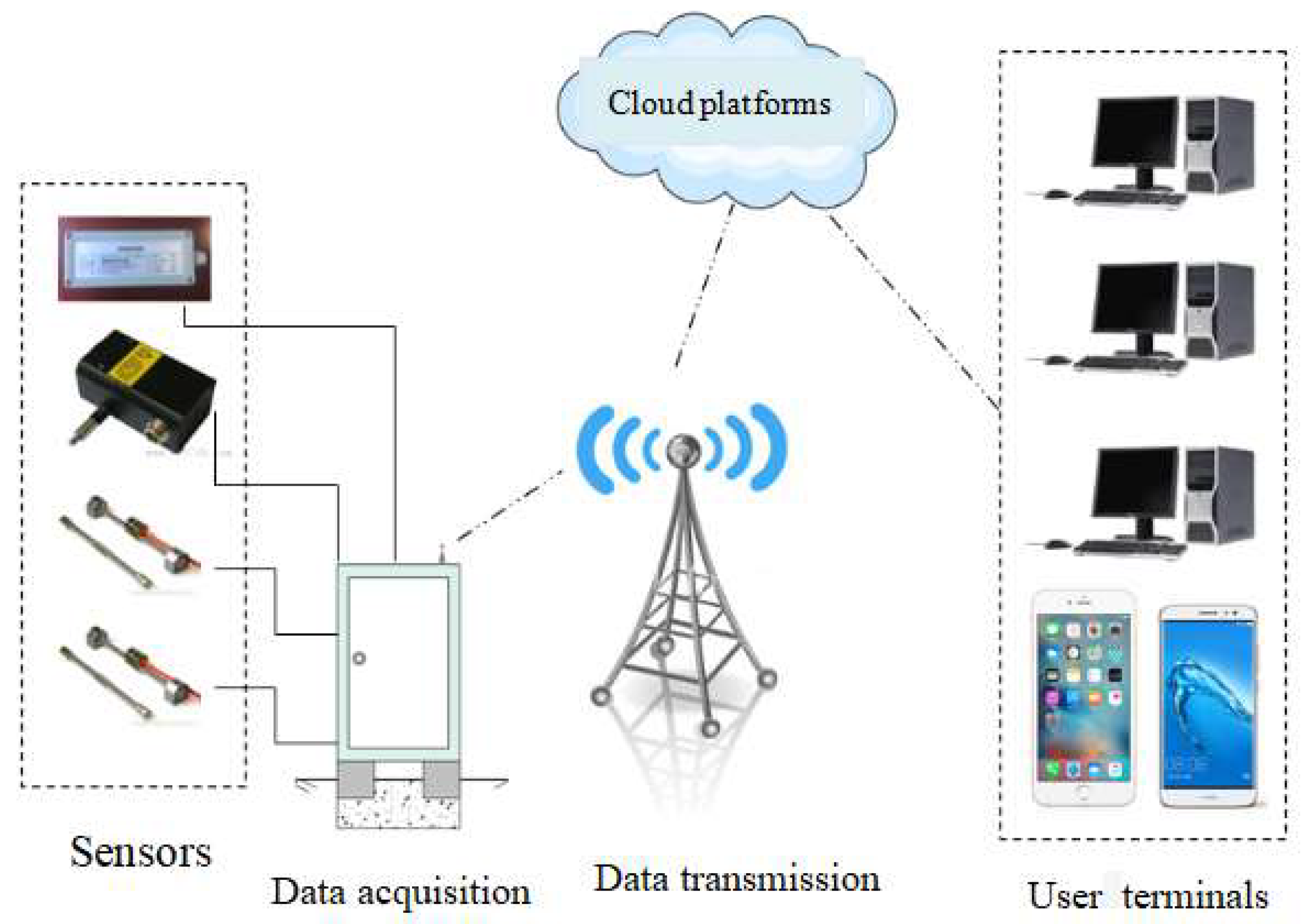
The remote real-time monitoring system uses cloud computing and 5S data transmission to complete automated monitoring, data collection, and early warning. The monitoring system is based on a cloud platform, which can collect and store massive amounts of data in real time. The system is composed of five parts, namely sensors, data acquisition modules, data transmission modules, cloud platforms, and user terminals, as shown in Figure 1.
(1) The interface of the sensing device is flexible and can be connected to displacement, deformation and force-measuring devices. It can conduct continuous or real-time continuous collection of various monitoring items of mine slopes.
(2) The data acquisition module controls the operation of the entire system, reads the sensor information and saves it.
(3) The data transmission module is based on the 5S transmission system, overcoming the drawbacks of traditional data transmission relying on a single GSM network. It is not affected by network signal sources and can transmit data in real time.
(4) The user terminal can be installed in PCs and mobile phones. The system can grant administrator permissions to different people, facilitating the viewing and changing of data and parameters at any time.
2.2. Hardware System Design
2.2.1. Sensor Hardware Design
High-Precision and Large-Range Cable Displacement Sensor
The high-precision and large-range pull-wire displacement sensor is shown in Figure 2. It is characterized by its small size, compact structure, large measuring strokes and high accuracy (0.01 mm). The high-precision and long-range pull-wire displacement sensor can measure the horizontal displacement of the mine slope with high precision. According to different working conditions, the maximum range can range from one hundred millimeters to ten meters. The relevant parameters of the sensor are shown in Table 1.
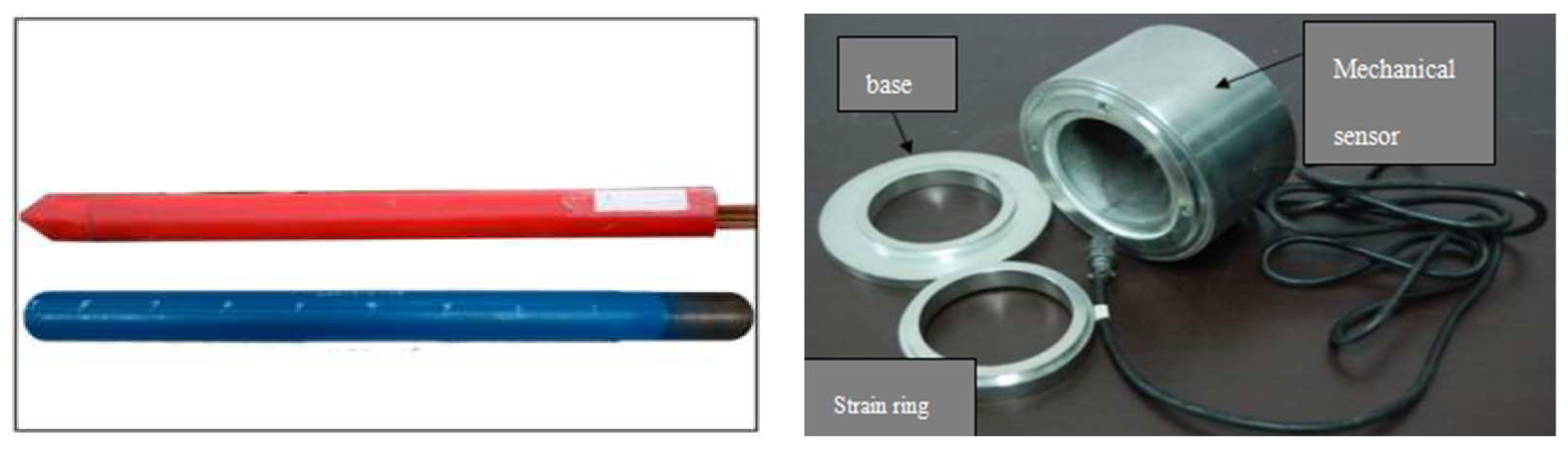
Force Sensor
The mechanical sensor mainly uses an NPR (Negative Poisson’s ratio) anchor cable and its supporting mechanical sensor device, as shown in Figure 3. The NPR cable has the characteristics of high constant resistance, large deformation and energy absorption. Its constant resistance can reach 1000 kN. The anchor cable can monitor the micro-deformation and micro-vibration of rock and soil through structural deformation and material deformation. The mechanics sensor is installed on the slope of the mine side slope, mainly to measure the mechanics of the anchor cable. It realizes the automatic collection and transmission function of the mechanical quantity, as shown in Figure 3. The technical parameters of NPR anchor cable are shown in Table 2.
2.3. Acquisition Module Hardware Design
The data-acquisition module converts and stores the monitoring data according to the control of the acquisition program and sends it to a remote monitoring computer through the data communication network for in-depth analysis and processing. In addition, the data-acquisition module can also receive control commands from the monitoring computer. It sends its own working status and the working status of the sensor to the monitoring computer. Finally, the technical engineer provides an analysis and judgment, and promptly eliminates the faults of the hardware equipment in the system. Through the selection of different measurement modules, data collection from various sensors with RS485 industrial standard interface can be realized. The acquisition module is shown in Figure 4.
2.4. Power Supply Module Design
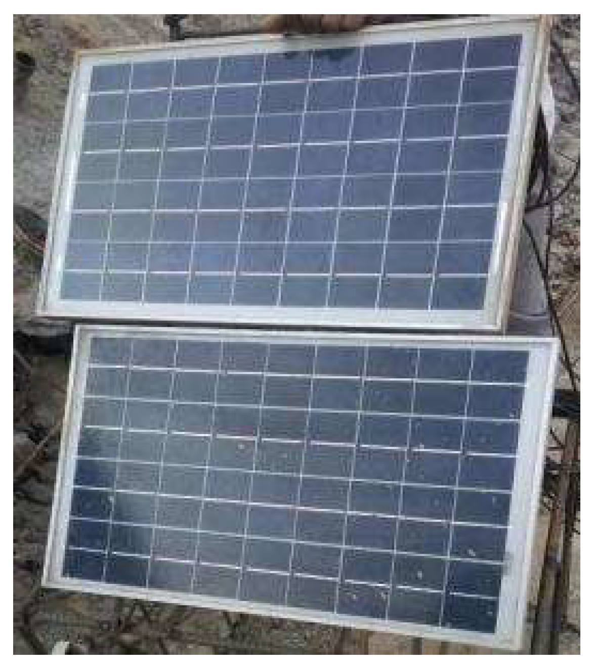
To meet the 24 h uninterrupted continuous monitoring of the monitoring station in the field, a field power supply system was designed. All the electricity required by the monitoring station comes from solar energy. The system includes three parts, i.e., solar panels, batteries, and solar controllers, as shown in Figure 5 and Figure 6. Solar panels are used to harvest solar energy and convert this into electrical energy. Batteries are used to store electricity and supply power to electrical equipment. The power controller is used to control the input and output of the battery current, which can also protect the battery.
2.5. Software System Design
5S-Based Data Transmission
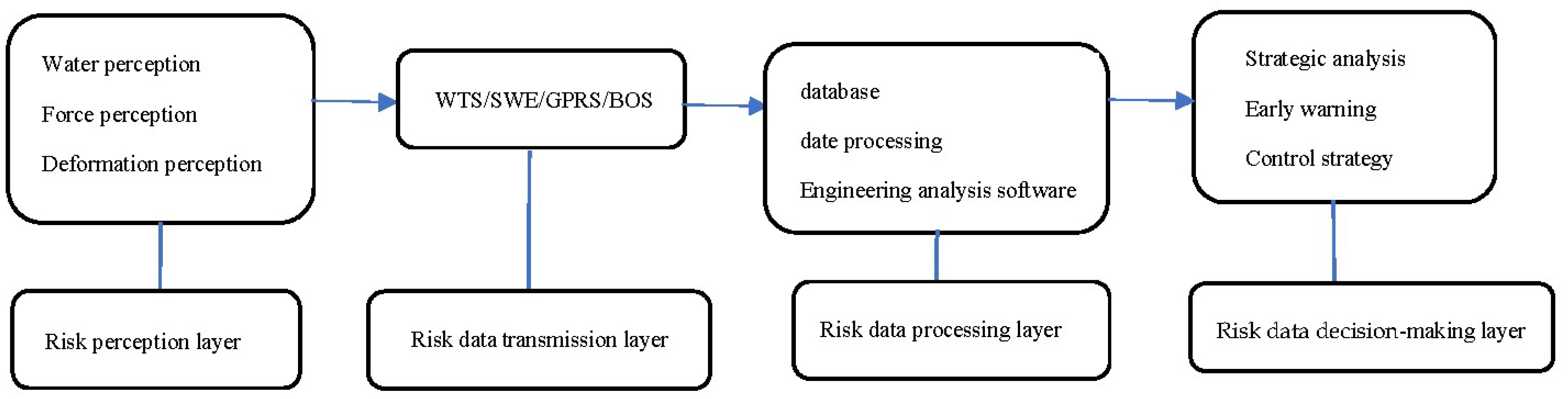
It is based on 5S technology, namely SMS (Short Message Service), WTS (Wireless transmission system), GPRS (General Packet Radio Service), GPS (Global Position System), BDS (BeiDou Navigation Satellite System), establish multiple methods (static collection, dynamic Collection), multiple locations (surface of rock and soil, deep part of rock and soil, supporting structure) and multimedia streaming monitoring data transmission system (Figure 7).
2.6. System Integration
The remote real-time monitoring system is based on .net and JAVA technology architecture, and the system classification and authority is shown in Table 3. The design and selection of technical routes follow the principles of openness, reliability, maturity, advancement, and safety. The database adopts Access and SQL together. The software adopts structured design. It has interactive functions, data-acquisition functions, analysis functions, uploading and early warning analysis functions. System users are divided into four levels, which are the super administrator, station administrator, station general user, station-browsing user. Users can query data monitoring maps and electronic maps in real time, as shown in Figure 8. Figure 8 can demonstrates whether the latest piece of data of the station is online. After the user clicks on the electronic map, a pop-up window will display the latest piece of data and basic information. The alarm is sent via SMS, and the user sets the alarm phone number by himself, and multiple phones can be set.
3. Results
3.1. Main Features
(1) This system realizes the organic integration of a cloud computing platform and 5S technology. It relies on the cloud-computing processing platform to achieve a large-capacity storage of data. It uses 5S technology to realize real-time data transmission, data processing and early warning decision-making.
(2) The system has rich interfaces, a large range and high accuracy. It adopts a high-precision and large-range pull-wire displacement sensor, which can record a greater number of data and a higher measurement accuracy of 0.01 mm.
(3) The system has a diversified power supply system. It can be powered by solar power, battery power, 220 V city power, and the power supply mode is automatically converted.
(4) Data monitoring is convenient and fast. Through computer, mobile phone and other terminal communication, users can observe, control, and query the information of the measuring points in real time anytime and anywhere. The early warning information can be sent to mobile phones of multiple people to realize the barrier-free real-time control of the monitoring information by the main person in charge of the project. The surface of the slope is mainly composed of Quaternary rock groups. The rock composition is dominated by chlorite schist and hornblende chlorite schist.
3.2. Engineering Applications
3.2.1. Topography and Lithology
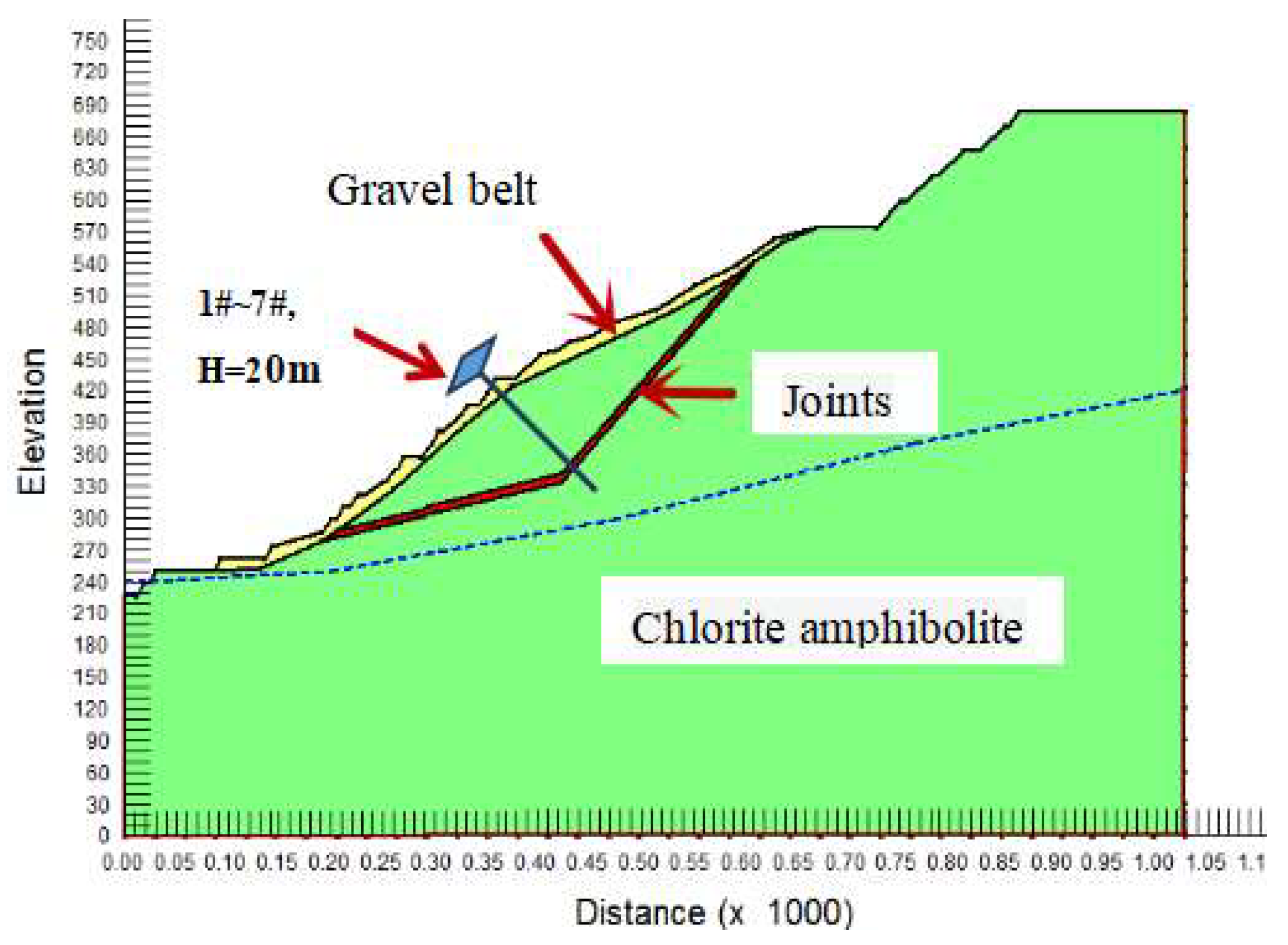
The Nanfen Open-pit Iron Mine is located on the platform of North China. The mining area belongs to the east–west eroded mid-mountain landform, the main structure is monoclinic, and the rock mass is mainly metamorphic. The average mountain height is 520–610 m, and the relative average height is 300–400 m. The joint inclination is 294°, the inclination angle is 30–60°. It intersects with the slope direction at a small angle. The entire slope belongs to the bedding stone slope (Figure 9).
3.2.2. Slope Horizontal Displacement Monitoring
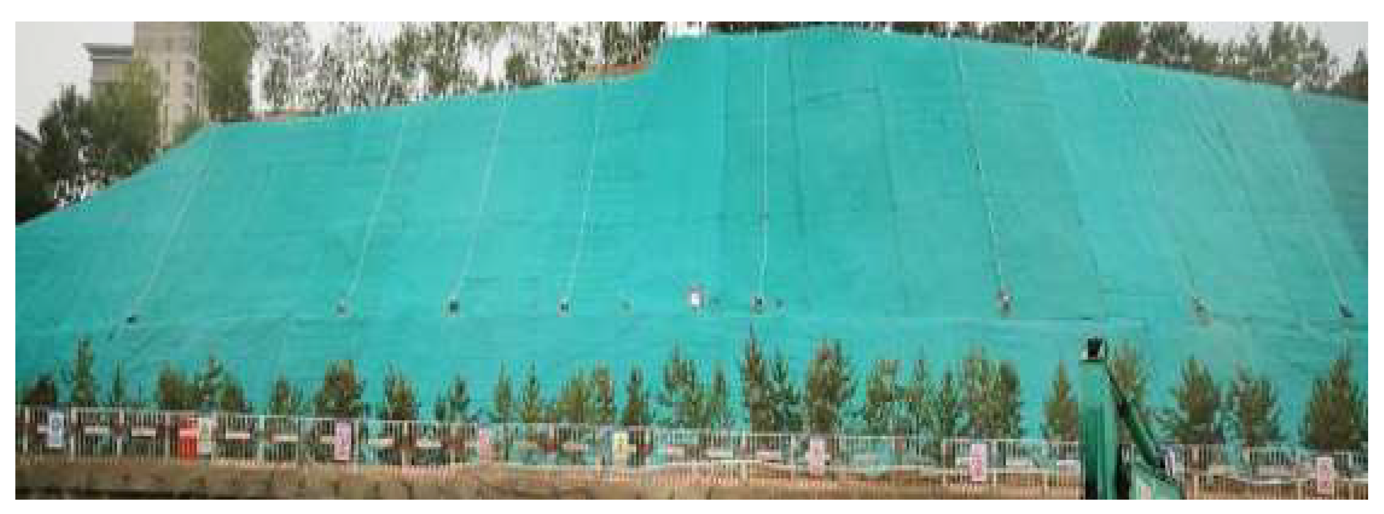
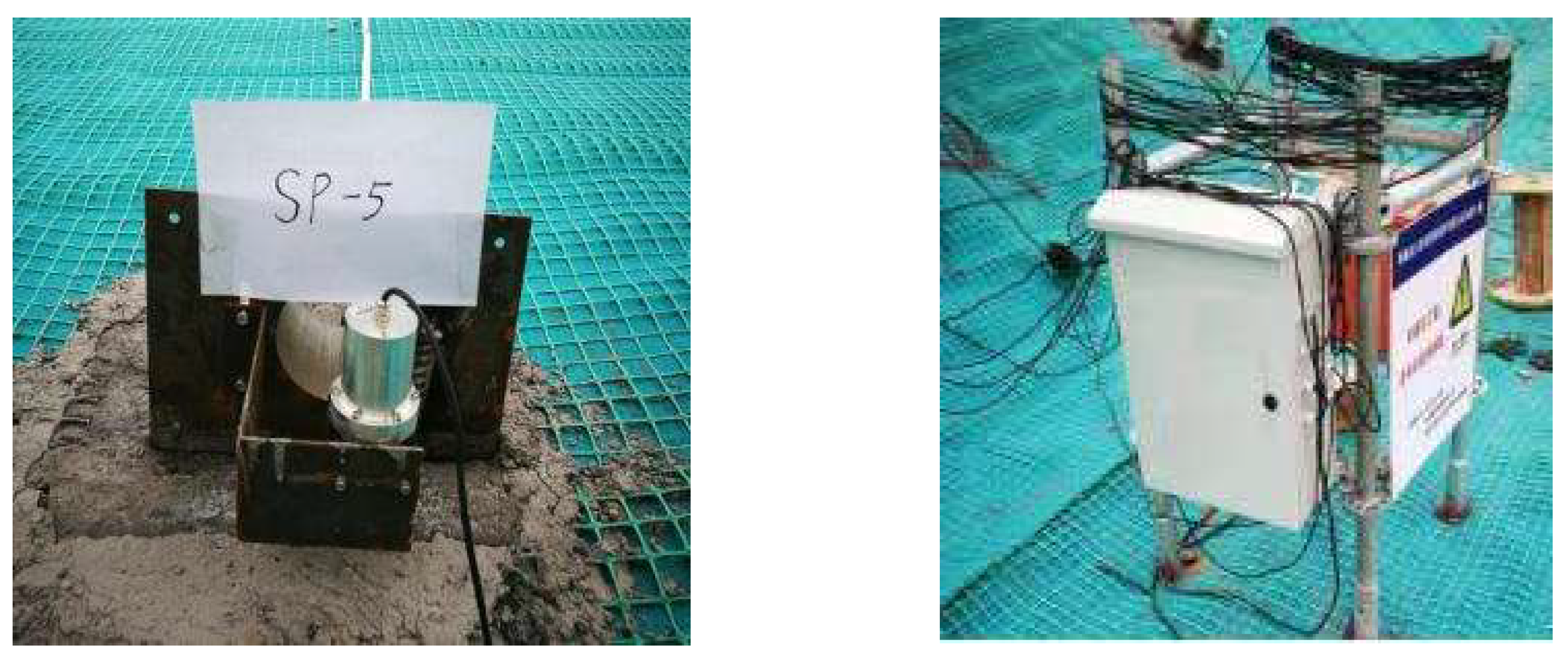
Due to the considerable height difference of the slope and the large inclination angle, the slope may have a potential sliding surface. Therefore, it is necessary to monitor the horizontal displacement of the slope surface in real time. Seven measuring points in a representative area were selected for monitoring, and the on-site measuring point layout is shown in Figure 10. The sensor and measuring station are shown in Figure 11.
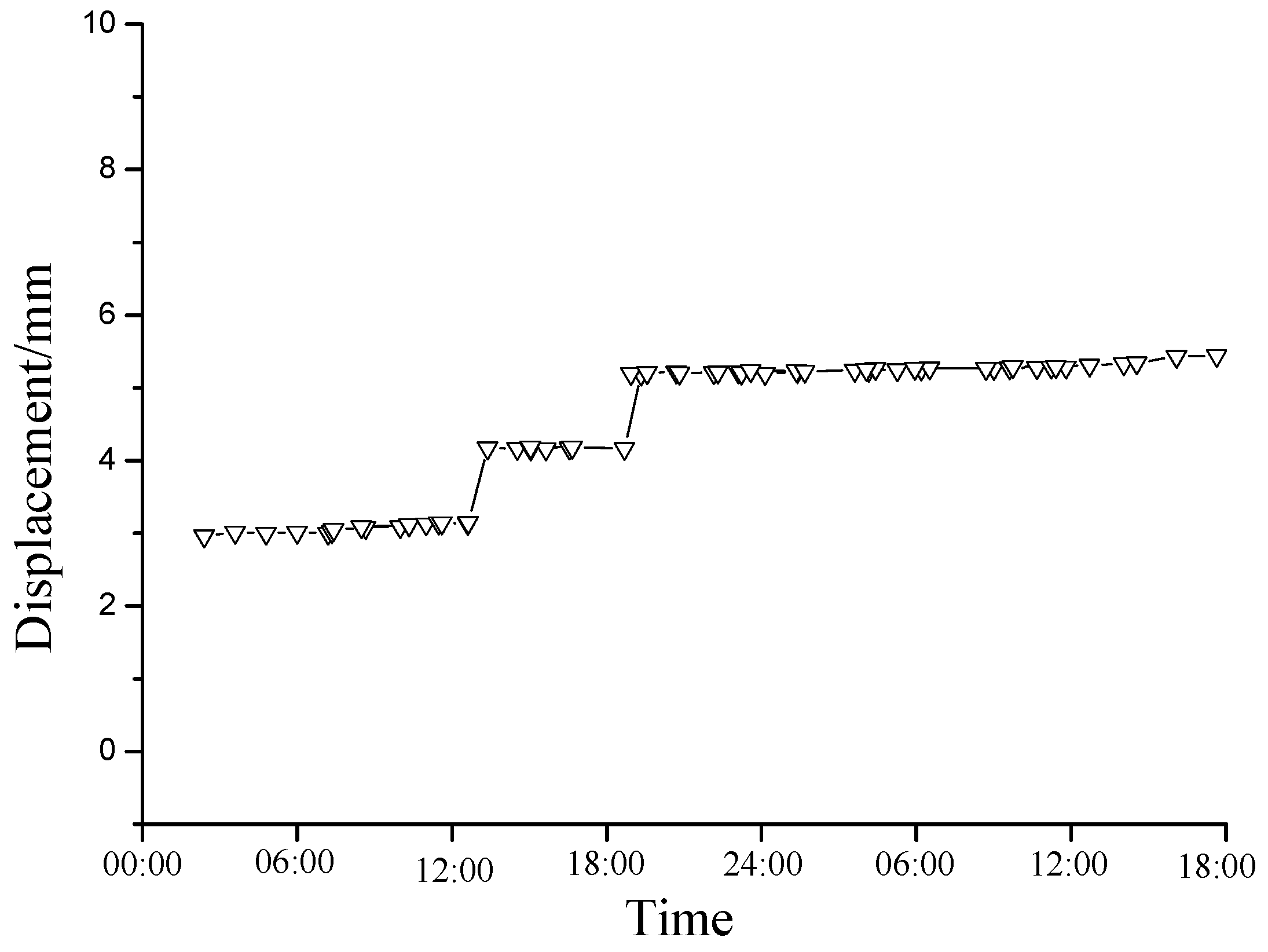
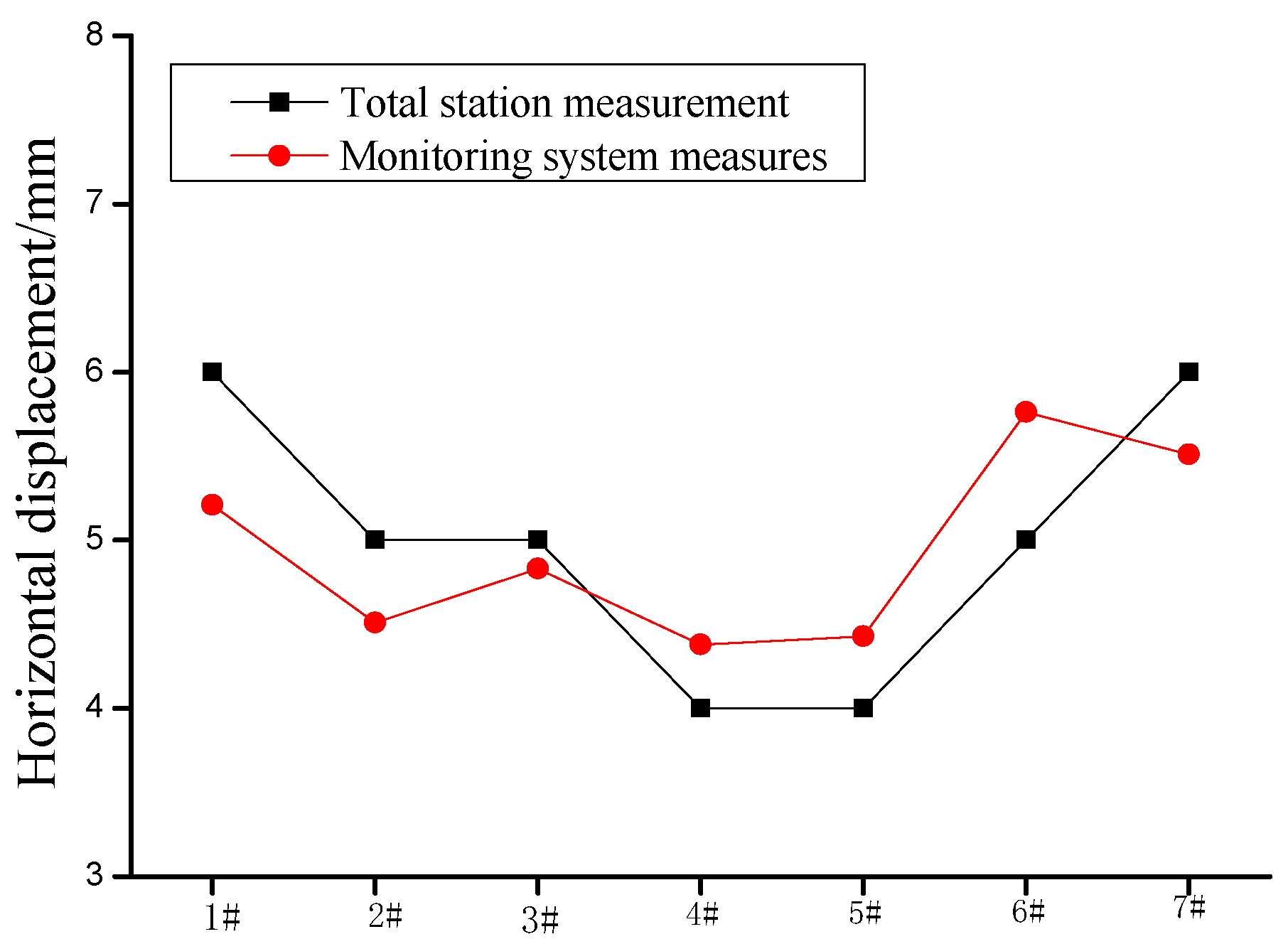
It can be seen from Figure 12 that the horizontal displacement measured by the total station and the monitoring system of the No. 1 and No. 2 measuring points gradually increased with the passing of time. The final measurement value of the total station at measuring point 1 is 6 mm, while the final measurement value of the monitoring system at measuring point 1 is 5.21 mm. The final measurement value of the total station at measuring point 2 is 5 mm, while the final measurement value of the monitoring system at measuring point 2 is 4.51 mm. It can be seen from Figure 13 that the horizontal displacement monitoring value of the 1#–7# monitoring system is from 4.38 mm to 5.76 mm. The results show that the horizontal displacement measurement results of the remote real-time monitoring system are highly reliable.
Compared with the other monitor measurement, the remote automatic monitoring system has higher accuracy, 24 h real-time measurement, saves on labor costs, and is less affected by objective factors. Therefore, it has a better monitoring and early warning effect on potential landslides, so as to prevent the excessive deformation of the mine slope and provide technical support for the mine slope disaster prevention and control.
4. Conclusions
Through experience, summary and theoretical analysis, database management and engineering analysis software suitable for 5S data transmission technology has been developed, and the early warning standard of slope has been determined by early warning values and the change mode of the monitored quantity. Through software programming, an intelligent slope warning cloud platform and APP with convenient access and high visualization degree were developed.
The system can monitor the multi-source parameters of the slope group, such as single-point displacement, two point relative displacement, anchor bolt tension, concrete strain, rainfall, temperature and humidity, inclination and groundwater level, and can automatically issue an early warning of a potential slope disasters by SMS and email.
The slope monitoring and early warning case study spanned more than two years, and verified the effectiveness of the slope remote monitoring and early warning cloud platform and app, revealing the slope horizontal displacement variation law and compared with the total station measurement results. It proved the reliability of the remote monitoring and early warning system.
In conclusion, compared with other monitoring methods, the remote slope monitoring and warning system based on cloud computing can monitor potential landslides with high precision, save human resources and also realized 24 h real-time monitoring.
Author Contributions
Y.Z. Conceptualization, Methodology, Investigation, Formal analysis, Writing—original draft. Y.L. Supervision, Validation, Funding acquisition, Writing—review& editing. Y.C. Translation and Checking the draft. All authors have read and agreed to the published version of the manuscript.
Funding
This study is supported by Hebei Provincial Universities’ Basic Scientific Research Operating Expenses (No. JQN2020027), the doctoral Research Initiation Fund of North China University of Science and Technology (No. 28418599).
Institutional Review Board Statement
Not applicable.
Informed Consent Statement
Not applicable.
Data Availability Statement
The original data that the current study was based on are first-hand, and the data is available.
Conflicts of Interest
The authors declare no conflict of interest.
References
- Jiang, S.; Tuo, X.G.; Shi, F.R.; Xing, Q.Y. A Landslide wireless network monitoring system. Met. Mine 2017, 46, 140. (In Chinese) [Google Scholar]
- Li, J.; Wu, S.C.; Gao, Y.T.; Xie, Y.L.; Ji, M.W. Review of slope micro-seismic monitoring in open-pit mine. Chin. J. Rock Mech. Eng. 2014, 33 (Suppl. S2), 3998–4013. (In Chinese) [Google Scholar]
- Lv, Z.Y.; Tuo, X.G.; Li, H.L.; Shi, F.R. Design on a new type of landslide wireless remote monitoring system. Met. Mine 2016, 10, 128–131. (In Chinese) [Google Scholar]
- Xu, X.D.; Zhu, W.C.; Zhang, P.; Li, X.X.; Li, X.; Wang, H. Construction and Preliminary Application of Cloud Platform for Monitoring and Early Warning of Mining Disasters in Metal Mines. Met. Mine 2021, 4, 160–171. (In Chinese) [Google Scholar]
- Jiang, X.X.; Li, C. Statistical analysis on coal mine accidents in China from 2013 to 2017 and discussion on the countermeasures. Coal Eng. 2019, 51, 101–105. (In Chinese) [Google Scholar]
- Lu, N.; Dong, Y.F.; Guo, S.T.; Wu, H.; Wang, X.L.; Zhang, Y. Improvement IQR Error Detection Method of Slope Deformation Monitoring of Open-pit Mine. Met. Mine 2018, 8, 114–117. (In Chinese) [Google Scholar]
- Xu, J.B.; Li, H.; Du, K.; Yan, C.; Zhao, X.; Li, W.; Xu, X. Field investigation of force and displacement within a strata slope using a real-time remote monitoring system. Environ. Earth Sci. 2018, 77, 552. [Google Scholar] [CrossRef]
- Wu, C.I.; Kung, H.Y.; Chen, C.H.; Kuo, L.-C. An intelligent slope disaster prediction and monitoring system based on WSN and ANP. Expert Syst. Appl. 2014, 41, 4554–4562. [Google Scholar] [CrossRef]
- Kroon, A.; Davidson, M.A.; Aarninkhof, S.; Archetti, R.; Armaroli, C.; Gonzalez, M.; Medri, S.; Osorio, A.; Aagaard, T.; Holman, R.; et al. Application of remote sensing video systems to coastline management problems. Coast. Eng. 2007, 54, 493–505. [Google Scholar] [CrossRef]
- Wang, Y.Q.; Zhang, S.B.; Chen, L.L.; Xie, Y.-L.; Wang, Z.-F. Field monitoring on deformation of high rock slope during highway construction: A case study in Wenzhou, China. Int. J. Distrib. Sens. Netw. 2019, 15, 1–15. [Google Scholar] [CrossRef]
- Sakurai, S.; Shimizu, N. Monitoring the stability of slopes by GPS. In Proceedings of the International Symposium on Stability of Rock Slopes in Open Pit Mining and Civil Engineering, Cape Town, South Africa, 12–14 October 2006; The South African Institute of Mining and Metallurgy: Johannesburg, South Africa, 2006; pp. 353–359. [Google Scholar]
- Cai, M. Principles of rock support in burst-prone ground. Tunn. Undergr. Space Technol. 2013, 36, 46–56. [Google Scholar] [CrossRef]
- Martín, A.; Anquela, A.B.; Dimas-Pagés, A.; Cos-Gayon, F. Validation of performance of real-time kinematic PPP. A possible tool for deformation monitoring. Measurement 2015, 69, 95–108. [Google Scholar] [CrossRef] [Green Version]
- Komac, M.; Holley, R.; Mahapatra, P.; van der Marel, H.; Bavec, M. Coupling of GPS/GNSS and radar interferometric data for a 3D surface displacement monitoring of landslides. Landslides 2015, 12, 241–257. [Google Scholar] [CrossRef]
- Zhang, Y.H.; Li, H.X.; Sheng, Q.; Wu, K.; Chen, G. Real time remote monitoring and pre-warning system for Highway landslide in mountain area. J. Environ. Sci. 2011, 23, 101–105. [Google Scholar] [CrossRef]
- Glabsch, J.; Heunecke, O.; Schuhback, S. Monitoring the Hornbergl landslide using a recently developed low cost GNSS sensor network. J. Appl. Geod. 2009, 3, 179–192. [Google Scholar] [CrossRef]
- Nunoo, S.; Tannant, D.D.; Newcomen, H.W. Slope monitoring practices at open pit porphyry mines in British Columbia, Canada. Int. J. Min. Reclam. Environ. 2016, 30, 245–256. [Google Scholar] [CrossRef]
- Panowicz, R.; Miedzińska, D. Numerical and experimental research on polyisocyanurate foam. Comput. Mater. Sci. 2012, 64, 126–129. [Google Scholar] [CrossRef]
- Pasierb, B.; Grodecki, M.; Gwóźdź, R. Geophysical and geotechnical approach to a landslide stability assessment: A case study. Acta Geophys. 2019, 67, 1823–1834. [Google Scholar] [CrossRef] [Green Version]
- Xu, G.L.; Zou, J.Y.; Yuan, H.; Liu, J.; Zhang, Y.; Liu, X.; Wu, Y.R. Rapid identification of landslide, collapse and crack based on low-altitude remote sensing image of UAV. J. Mt. Sci. 2020, 17, 66–79. [Google Scholar]
- Robet, M.K.; Arthur, E.L.; William, L.D. Determination of prestressin granular soils using AE. J. Geotech. Eng. 1984, 110, 346. [Google Scholar]
- Smith, A.D.; Fowmes, G.J. Early detection of first-time slope failures using acoustic emission measurements: Large-scale physical modeling. Géotechnique 2017, 67, 138–152. [Google Scholar] [CrossRef] [Green Version]
- Dixon, N.; Smith, A.; Spriggs, M.; Ridley, A.; Meldrum, P.; Haslam, E. Stability monitoring of a rail slope using acoustic emission. Proc. Inst. Civ. Eng.-Geotech. Eng. 2015, 168, 373–384. [Google Scholar]
- Julien, T.; Jean-Philippe, M.; Christophe, D. Image-based correlation of Laser Scanning point cloud time series for landslide monitoring. Int. J. Appl. Earth Obs. Geoinf. 2014, 32, 1–18. [Google Scholar]
- Yin, Y.P.; Zheng, W.M.; Liu, Y.P.; Zhang, J.; Li, X. Integration of GPS with In-SAR to monitoring of the Jiaju landslide in Sichuan, China. Landslides 2010, 7, 359–365. [Google Scholar] [CrossRef]
- Zhong, C.; Li, H.; Xiang, W.; Su, A.; Huang, X. Comprehensive study of land-slides through the integration of multi remote sensing techniques: Framework and latest advances. J. Earth Sci. 2012, 23, 243–252. [Google Scholar] [CrossRef]
- Xu, Q.; Peng, D.L.; He, Z.Y.; Qi, X.; Zhao, K.; Xiu, D. Study on theory and method of monitoring and early warning for sudden loess landslide:a case study on the Heifangtai terrace in Gansu. J. Eng. Geol. 2020, 28, 111–121. [Google Scholar]
- Aghda, S.M.F.; Ganjalipour, K.; Nabiollahi, K. Comparison of performance of inclinometer casing and TDR technique. J. Appl. Geophys. 2018, 150, 182–194. [Google Scholar] [CrossRef]
- Pei, H.F.; Jing, J.H.; Zhang, S.Q. Experimental study on a new FBG based and Terfenol-D inclinometer for slope displacement monitoring. Measurement 2020, 151, 1016–1046. [Google Scholar] [CrossRef]
- Chen, Y.L.; Zuo, J.P.; Liu, D.J.; Li, Y.J.; Wang, Z.B. Experimental and numerical study of coal-rock bimaterial composite bodies under triaxial compression. Int. J. Coal Sci. Technol. 2021, 8, 908–924. [Google Scholar] [CrossRef]
Figure 1.
Monitoring system composition.

Figure 2.
High-precision and large-range cable displacement sensor.

Figure 3.
Sensors for measuring force and deformation.

Figure 4.
Data acquisition module.

Figure 5.
Solar panel.

Figure 6.
Accumulator.

Figure 7.
5S-based data transmission flow chart.

Figure 8.
Real-time data monitoring chart for 42 h.

Figure 9.
Slope geological model.

Figure 10.
Layout of measuring points for slope horizontal displacement.

Figure 11.
Pull-wire displacement sensor and station.

Figure 12.
Time history curve comparison. (a) Time history curve of No. 1 measuring point, (b) Time history curve of No. 2 measuring point.
Figure 12.
Time history curve comparison. (a) Time history curve of No. 1 measuring point, (b) Time history curve of No. 2 measuring point.

Figure 13.
Comparison chart of horizontal displacement of monitoring points.


Table 1.
High-precision and large-range cable displacement sensor parameter.
| Voltage | Current | Output Interface | Resolution | Precision | Maximum Range | Temperature |
|---|---|---|---|---|---|---|
| 9–24 v | 0.1 A | RS485 | 0.025 mm | 0.1% FS | 500 mm | 35–800 °C |
Table 2.
Technical parameters of NPR cable.
| Index Name | Performance |
|---|---|
| Measuring range | 0–1500 KN |
| Power supply voltage and output sensitivity accuracy | 10 V DC output: 4 pc/N 24 V DC output: Current signal 4~20 mA, Voltage signal: 0~5 VDC |
| Precision | ±0.5% F·S, ±1% F·S |
| Zero temperature drift | <0.2% F·S/10 °C |
| Sensitivity drift | <0.2% F·S/10 °C |
| Insulation resistance | ≥100 MΩ |
| Operating temperature | −40~150 °C |
| Natural frequency | ≥55 KHz |
Table 3.
System classification and authority.
| Category | Super Administrator | Station Administrator | General User of Station | Station Browsing Users |
|---|---|---|---|---|
| Authority | All permissions | Add, edit, delete general users of the station | View, add, delete and modify station | View designated station |
Publisher’s Note: MDPI stays neutral with regard to jurisdictional claims in published maps and institutional affiliations. |
© 2022 by the authors. Licensee MDPI, Basel, Switzerland. This article is an open access article distributed under the terms and conditions of the Creative Commons Attribution (CC BY) license (https://creativecommons.org/licenses/by/4.0/).
Share and Cite
MDPI and ACS Style
Zhou, Y.; Li, Y.; Chen, Y. Remote Real-Time Monitoring System for Mine Slope Based on Cloud Computing. Water 2022, 14, 714. https://doi.org/10.3390/w14050714
AMA Style
Zhou Y, Li Y, Chen Y. Remote Real-Time Monitoring System for Mine Slope Based on Cloud Computing. Water. 2022; 14(5):714. https://doi.org/10.3390/w14050714
Chicago/Turabian StyleZhou, Yijun, Yanlin Li, and Yulong Chen. 2022. "Remote Real-Time Monitoring System for Mine Slope Based on Cloud Computing" Water 14, no. 5: 714. https://doi.org/10.3390/w14050714
Note that from the first issue of 2016, this journal uses article numbers instead of page numbers. See further details here.