

Characterization of Water and Total Nitrogen Contributions from the Inflow Rivers to Lake: A Study of West Dongting Lake in China
1
Chinese Research Academy of Environmental Sciences, Beijing 100012, China
2
National Joint Research Center for Yangtze River Conservation, Beijing 100012, China
*
Author to whom correspondence should be addressed.
Water 2022, 14(21), 3463; https://doi.org/10.3390/w14213463
Submission received: 18 August 2022
/
Revised: 27 October 2022
/
Accepted: 27 October 2022
/
Published: 30 October 2022
(This article belongs to the Special Issue Water Quality Monitoring, Analysis and Restoration of Lakes)
Abstract
:The input of pollutants into the lake has ainfluence on the water quality of the lake. Detailing the contribution of water and nutrients from the inflow rivers are essential for lake water management. Major ions Na+ and Cl− were applied to trace contributions of water and total nitrogen (TN) from the inflow rivers to West Dongting Lake. By using the two-source mixing model and the two-component TN mixing model, the results showed that water and TN in West Dongting Lake were mainly contributed by local rivers rather than the three outfalls, in which the contribution of Yuan River was larger than that of Li River. However, the contribution rates of water and TN of the three outfalls to West Dongting Lake during the wet season reached above 20% and 30%, respectively, indicating that the contribution of the three outfalls to West Dongting Lake could not be ignored. Among them, the contributions of Songzi outfall were higher than those from Taiping and Ouchi outfalls. Therefore, we suggest that the relevant departments should identify key river management targets during different water periods, implement refined management over water pollution in West Dongting Lake, and prioritize the pollutant input of Yuran River and Songzi outfall (especially during the wet season). This study demonstrates that major ion tracing is suitable for estimating the contribution rates of different nutrient sources in the river-lake system, which will provide valuable information for protecting the water quality of West Dongting Lake in the future.
1. Introduction
The term “major ions” refers to inorganic ions that can coexist in water for a long time and are not easily precipitated during migration. The ions which are commonly found in freshwater usually include Cl−, Ca2+, , F−, , Na+, Mg2+, and K+. Some of these ions are relatively stable in the process of river water transport and have conservative properties. They are significantly different from most other trace components, which are prone to enrichment, sedimentation, and chemical reactions. Therefore, these major ions act as tracers in the process of water exchange and serve as indicators for different water sources [1,2].
Ion tracing is similar to the method used to indicate estuary salinity, and this type of research has been widely used in estuaries where the sea and land meet [1,3,4,5,6]. However, ion tracing is seldom used in the study of rivers and reservoirs. In recent years, some scholars in China have applied major ion tracing to the study of inland estuaries (bay areas). Yang et al. [7] and Chen et al. [8] used the major ions as indicators to study the water mixing process in the estuarine confluence area of the Xiangxi River-Yangtze River system and to quantitatively analyze the nutrient supplements of stratified density currents in the estuary to the Xiangxi River. Zhao et al. [9] applied inorganic major ion tracing to analyze and reveal the chemical characteristics of the water mass in the confluence zone of the Daning River-Yangtze River system during the interaction process. In summary, the use of major ion tracing has a research basis in the estuaries of freshwater rivers, river-reservoir systems, and inland estuaries (bay area). However, there are still some river-lake systems in the inland, and the application of this type of system has not yet been reported. Therefore, it will be meaningful to carry out major ion tracing research in river-lake systems, which can not only enrich relevant knowledge, but also provide reference for other scholars to carry out relevant research.
Dongting Lake is located in the northeast area of Hunan Province, on the south bank of the Jingjiang River in the middle and lower reaches of the Yangtze River. It is the second-largest freshwater lake in China and the first lake directly connected with the Yangtze River after the water from the Three Gorges Dam enters the middle and lower Yangtze River plain [10,11]. Dongting Lake receives recharge from the Xiangjiang and Zishui Rivers in the south and the Yuan and Lishui Rivers in the west, as well as water inflows from the Songzi, Taiping and Ouchi outfalls (three outfalls) from the Yangtze River in the northwest and the Xinqiang and Miluo Rivers in the east. The inflow water is regulated by Dongting Lake and then flows out of the lake into the Yangtze River. In other words, Dongting Lake is an inland lake with a flood channel and has a complex river-lake relationship with its inflow rivers [12].
In the past 30 years, the water quality of Dongting Lake has been on the decline, and total nitrogen (TN) and total phosphorus (TP) are the main factors affecting the water quality [13]. With the increase in TN and TP pollutant input, the water quality of Dongting Lake decreased, and the water trophic status was gradually close to the light eutrophication from the mesotrophic level [14]. Many scholars pay more attention to TP than to TN when studying the water environment and nutrient status of Dongting Lake. However, TN is also one of the main factors causing water pollution, and the TN input from the inflow rivers to Dongting Lake cannot be ignored. Therefore, it is necessary to clarify the water supply process of the inflow rivers to Dongting Lake and the main sources of TN in the lake under the background of the river-lake system, as this information would have a great significance for guiding the prevention and control of water pollution in the lake.
This study focused on West Dongting Lake (WD), which receives recharge from three outfalls and the Yuan and Lishui Rivers. The water index data were obtained using field investigations and laboratory experiments. This study aimed to (1) establish an analysis method suitable for a lake connected to a river and quantitatively analyze the contributions of water and TN from different water sources to West Dongting Lake in different water periods; (2) identify the replenishment mode of the inflow river to West Dongting Lake and the influence of the inflow river on the TN distribution in West Dongting Lake under multisource compound actions; (3) enrich the quantitative understanding of pollution factor of water environment change in West Dongting Lake and provide management suggestions for the prevention and control of water pollution in West Dongting Lake.
2. Materials and Methods
2.1. Study Area
Dongting Lake, which is located in the northeast of Hunan Province and in the middle and lower reaches of the Yangtze River (111°53′~113°08′ E, 28°44′~29°35′ N) in China, has a natural water surface area of approximately 2691 km2 and a volume of approximately 1.74 × 10¹⁰ m3. Because of the historical evolution and extensive sediment deposition in Dongting Lake, the lake has been divided into three sub lakes, i.e., West Dongting Lake, South Dongting Lake, and East Dongting Lake [15]. West Dongting Lake spans Hubei and Hunan Provinces in China in the western part of the Dongting Lake area. Local rivers (the Yuan and Lishui Rivers) are the west input of West Dongting Lake, and the water flow of the three outfalls (the Taiping outfall, the Songzi outfall, and the Ouchi outfall) of the Yangtze River are the north input of West Dongting Lake [16]. The water-sand conditions, hydrological conditions, and water quality of West Dongting Lake are all affected by the joint action of the Yangtze River and local rivers.
2.2. Water Sampling
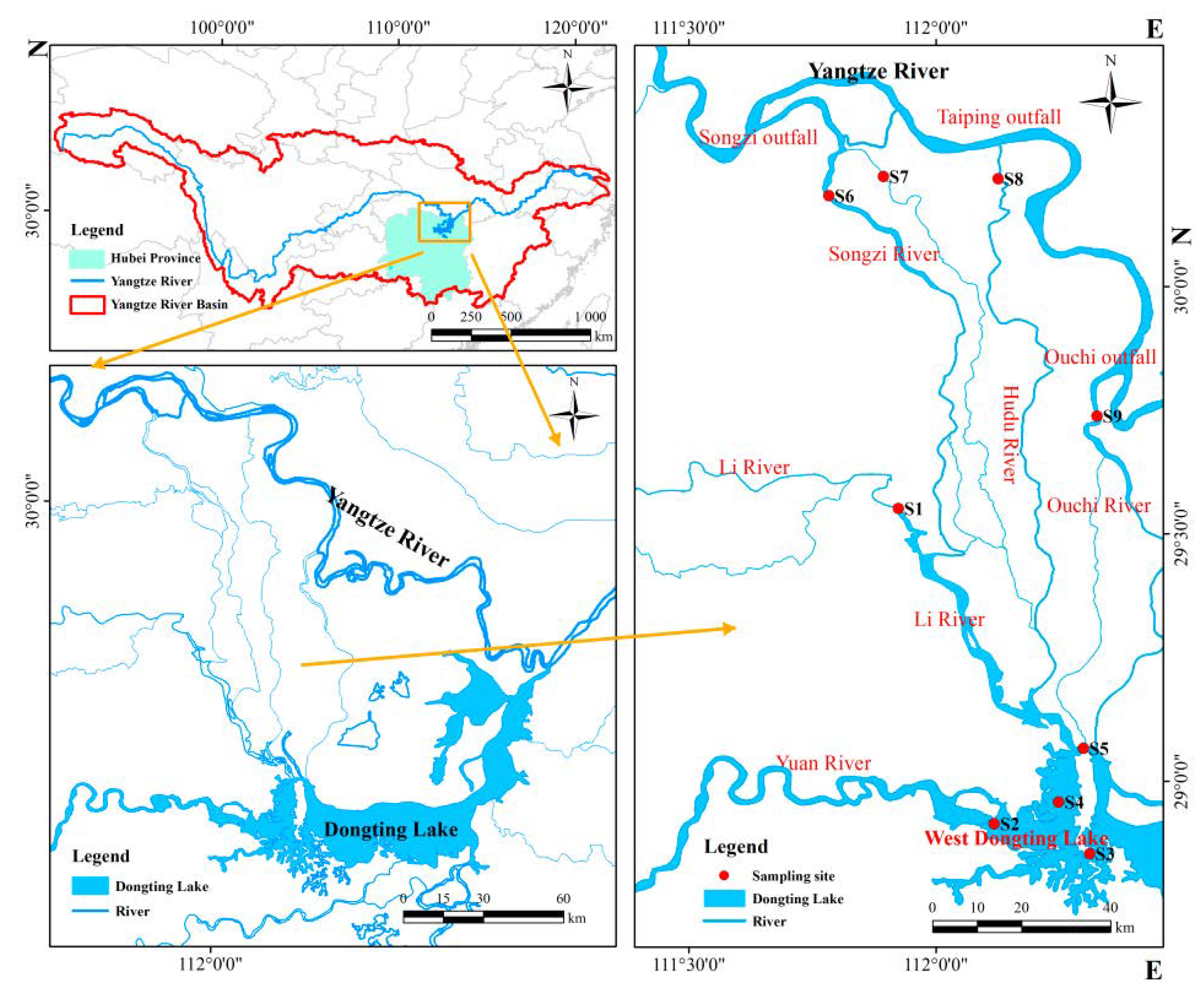
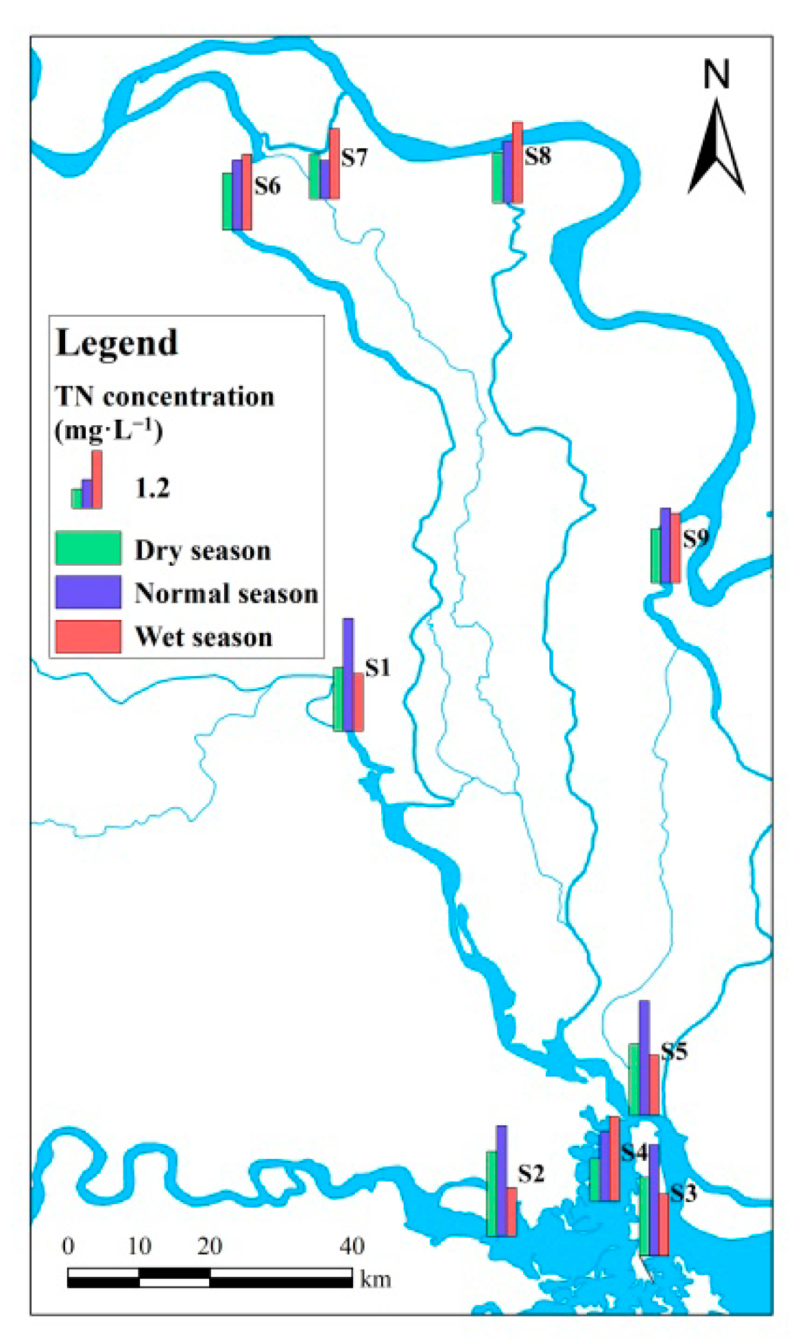
Surface water samples were collected from a depth of 0.5 m at 9 sampling sites located in West Dongting Lake and its inflow rivers. The samples were divided into three spatial groups. S1 and S2 represented the flows from the local rivers, S3–S5 represented West Dongting Lake, and S6–S9 represented the flows from the three outfalls of the Yangtze River. The distribution and basic information of the sampling sites are shown in Figure 1 and Table 1, respectively.
Water samples were collected in the first week of December 2016, April 2017 and August 2017. According to the hydrological rhythm of Dongting Lake [17], these sampling periods occurred during the dry season, the normal season, and the wet season, respectively. Part of each water sample was filtered through cellulose acetate membranes (0.45 μm) for the determination of major ions, and these samples should to be stored at 4 °C and protected from light (brown sample bottles). The remaining samples were stored in the sample bottle and brought to the laboratory for the determination of the nutrients.
2.3. Measurement and Data Collection
The concentrations of major ions, including Cl−, Ca2+, , F−, , Na+, Mg2+, and K+, in all water samples were measured using American Dionex ion chromatography (ICS-2100). The relative standard deviation for the test data was less than 5%. The concentrations of TN were determined by UV spectroscopy (UNICO, UV752N) after pretreatment by alkaline potassium persulfate oxidation [18]. The hydrological data during the sampling periods were obtained from the website named Hunan Hydrological [19], which was monitored by hydrological stations located very close to the sampling sites.
2.4. Methods
2.4.1. Water Contribution Rates from the Local River System and from the Yangtze River System to West Dongting Lake
The exchange process of nutrients between West Dongting Lake and its inflowing rivers is accompanied by the water mass exchange process. Under the premise that the nutrients themselves are difficult to trace, the tracer method was effective in exploring the water contribution from each source to West Dongting Lake and then indirectly calculating the contributions of nutrients [20]. Nutrients are prone to physical and chemical reactions during the water mass exchange process, so they were not suitable as markers of the water mass exchange [1]. However, it is difficult for major ions to precipitate through chemical reactions in the water body, and major ions have good chemical conservative characteristics [21]. Therefore, these ions were applied to trace the sources of different water masses in West Dongting Lake according to the principle of mass conservation. Dongting Lake is located in the middle of the Yangtze River basin, and precipitation is the most important supply of surface water in the basin, so the water in Dongting Lake basin mainly comes from surface runoff rather than groundwater [22,23]. The input of pollutants in Dongting Lake mainly comes from the inflow river channel, pollution sources around the lake, surface runoff, atmospheric precipitation, etc. From the perspective of the amount of pollutant input, the pollutant input of the inflow rivers entering the lake is the largest [24]. Thus, the largest pollution source of West Dongting Lake is mainly its inflow rivers. West Dongting Lake is recharged by the Yuan and Lishui Rivers and the three outfalls. In terms of sources, the waters flowing through three outfalls are mainly from the Yangtze River, and the Lishui and Yuan Rivers are mainly located in Hunan Province. After simplification, the water sources of West Dongting Lake can be classified into two categories: the Yangtze River system (YR) and the local river system (LR). Therefore, according to the principle of mass conservation, the water-ion mass balance equation of these two sources was constructed by using the conservative major ions as tracers [8,25]. Then, thse equation was used to calculate the water contribution rates from the Yangtze River system and the local river system to West Dongting Lake. The rates were calculated by Formula (1), known as the two-source mixing model [26].
where xYR and xLR represent the water contribution rates of the Yangtze River system and the local river system to West Dongting Lake (%), respectively, and CYR, CLR and CWL refer to the average tracer ion concentrations of the Yangtze River system, the local river system and West Dongting Lake (mg·L−1), respectively.
CWL was the arithmetic mean value calculated using the ion concentrations in the water bodies of the West Dongting Lake sampling sites. There are several rivers in the Yangtze River system and the local river system. The sampling sites were distributed on different rivers in these systems. To reduce the difference between the rivers, the flow weighted average method [27] was used to calculate CYR and CLR, as shown in Formula (2).
where Ci is the concentration of tracer ions in the i-th sites of the Yangtze River system (mg·L−1), and Qi is the flow of the i-th sites of the Yangtze River system, as expressed by the monthly average flow during the month in which water samples were taken (m3).
CLR was calculated in the same way as CYR.
2.4.2. TN Contribution Rates from the Local River System and from the Yangtze River System to West Dongting Lake
Under the condition that the TN concentrations of the water from the Yangtze River system and the local river system were known, the mass conservation tracing model of TN was constructed based on the results of the two-source mixing model to calculate the TN contribution rates from the Yangtze River system and the local river system to West Dongting Lake. The rates were calculated using Formulas (3) and (4):
NWL = xYR NYR + xLR NLR
fYR = xYRNYR/NWL, fLR = xLRNLR/NWL
The combination of Formulas (3) and (4) is the two-component TN mixing model [25], where fYR and fLR represent the TN contribution rates of the Yangtze River system and the local river system to West Dongting Lake (%), respectively. The parameters of NWL, NYR and NLR are the TN concentrations of West Dongting Lake, the Yangtze River system and the local river system (mg·L−1), respectively. Similar to CYR, NYR and NLR were calculated using the flow weighted average method, as shown in Formula (2). The parameters of xYR and xLR were calculated using Formula (1).
The estimation deviations of the TN contribution rates were calculated as follows:
where P is the estimation deviation of the TN contribution rate(%), the smaller the absolute value of P, the higher the applicability of the ion tracing model. NWL is the estimated concentration of TN in West Dongting Lake, as calculated by Formula (3) (mg·L−1), and RWL is the measured TN concentration in West Dongting Lake (mg·L−1).
P = (NWL − RWL)/NWL
3. Results
3.1. Screening and Spatiotemporal Distribution Characteristics of the Tracer Ions
3.1.1. Screening the Tracer Ions
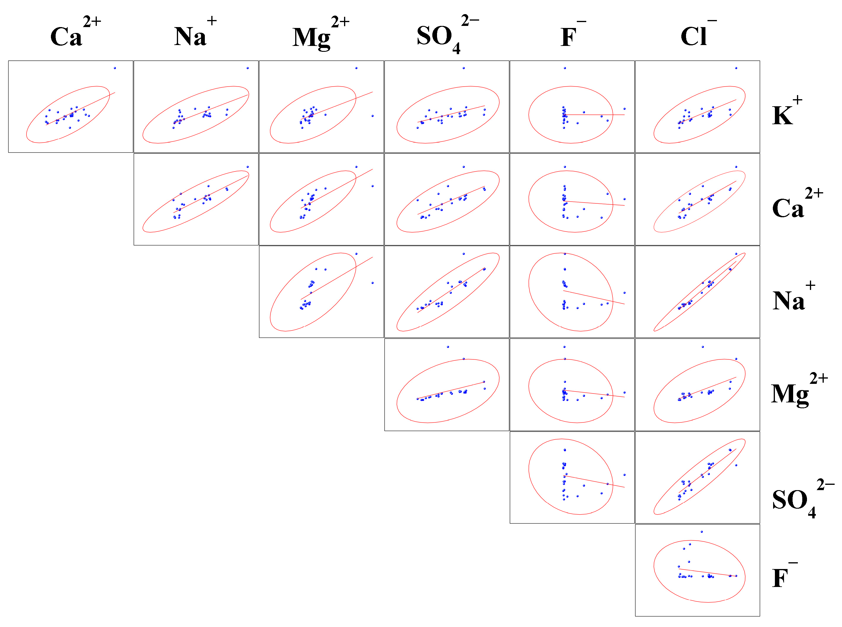
In the process of river water transportation, only ions that always maintain chemically conservative properties are regarded as tracer ions; notably, is easily absorbed by algae as a nutrient so is generally not considered to be a conservative ion. The conservative properties of tracer ions are mainly reflected in two aspects. First, there should be a linear correlation between the ion concentrations that indicates that the ions are conservative during the migration process [1,2,28]. Second, the concentrations of the ions between the different water sources should have a stable and large difference.
There were significant or extremely significant correlations between all ions but F− (Figure 2 and Table 2), and Na+, Cl− and Ca2+ had extremely significant correlations with other major ions. Na+, Cl−, Ca2+ and had good linear relationships with each other, and the correlation coefficients of these relationships were all above 0.8 (except for the correlation coefficient between Ca2+ and , which was 0.700), showing extremely significant correlations (Table 2). It was concluded that the tracer ions suitable for West Dongting Lake could be selected from these four ions.
To further screen the tracer ions, the difference in the ion concentrations between the Yangtze River system and the local river system was used as a reference. The major ion concentrations in the Yangtze River system and the local river system and their differences are presented in Table 3. Because F− was poorly correlated with the other ions, it was not considered in the analysis. During the different water periods, the concentrations of Na+ and Cl− in the local river system were all below 5 mg·L−1 (except for that of Cl− in the dry season, 5.303 mg·L−1), while the concentrations of Na+ and Cl− in the Yangtze River system were all above 10 mg·L−1. Based on the Yangtze River system, the percent differences in the concentrations of Na+ and Cl− between the Yangtze River system and the local river system were above 65% in all three water periods, which indicated that Na+ and Cl− remained stable and their concentrations had the large differences in water sources. Although the concentrations of Ca2+ and and the differences in these concentrations between the Yangtze River system and the local river system were relatively stable in all the water periods, their percent differences were much lower than those of Na+ and Cl−. As shown in Table 2, the correlation between Na+ and Cl− was the best among all ion relationships (R = 0.982, p < 0.01), and Figure 2 shows that the 95% confidence interval in the scatter plot of Na+-Cl− was the narrowest, showing the best linearity and satisfying conservative characteristics. Moreover, Na+ and Cl− are generally not easily absorbed by colloids, are not bioaccumulated, and do not form insoluble minerals. Their behavior in water is very similar to that of water molecules, and they can be considered ideal tracer ions [29]. Thus, we selected Na+ and Cl− as the tracer ions in different water sources in this study.
3.1.2. The Spatiotemporal Distribution Characteristics of Tracer Ions
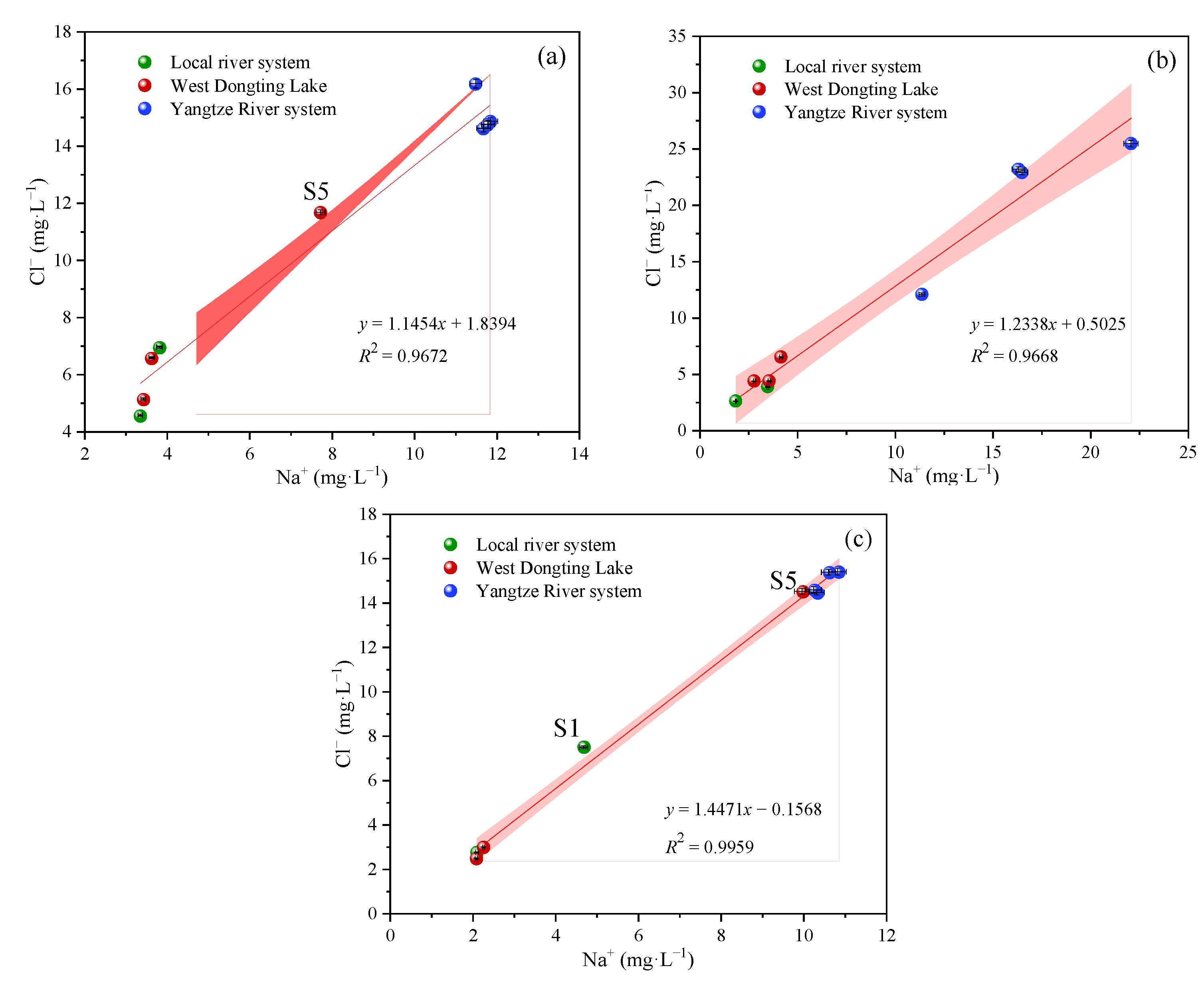
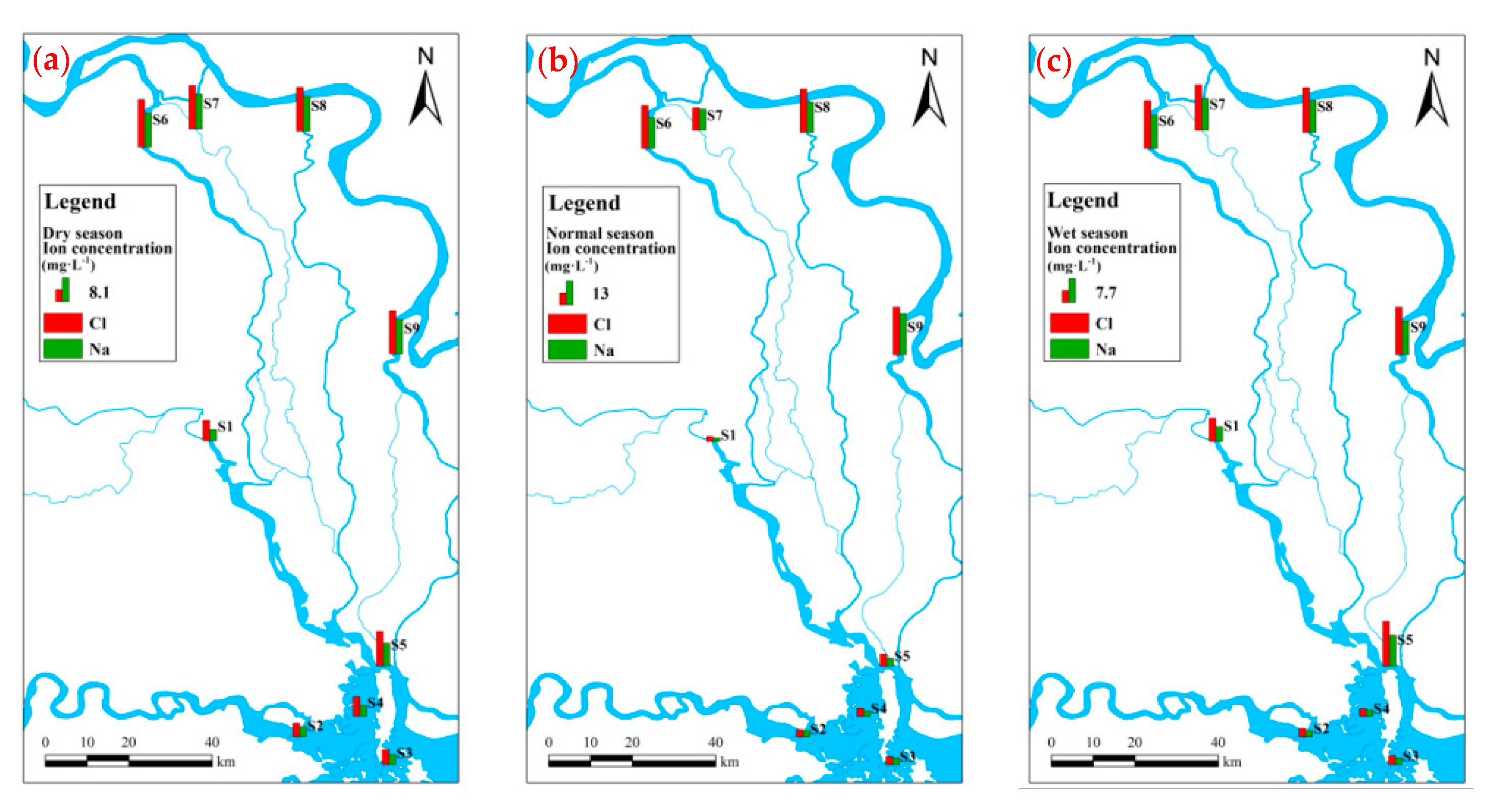
In all periods, the correlation coefficients between the concentrations of Na+ and Cl− were above 0.9, with values of 0.9672 (the dry season), 0.9668 (the normal season) and 0.9959 (the wet season), and thus showed an excellent linear correlation (Figure 3). However, there were differences in the concentrations of tracer ions between the water sources in each water period. The ion concentration of each river in the Yangtze River system was higher than that of each river in the local river system, and the difference in the ion concentrations between West Dongting Lake and the local river system and between West Dongting Lake and the Yangtze River system was varied in different water periods (Figure 4).
When water sources have significantly different ion concentrations, the closer the ion concentration of the receiving water body is to that of the certain water source, the greater the influence of this source on the receiving water body is, and the more similar the chemical characteristics of the two are [30]. During the dry season, the ion concentrations of S3 and S4 were close to those of the sites in the local river system, while the ion concentrations of S5 was plotted in the middle of the curve (Figure 3a). These results indicated that the local rivers had a great influence on S3 and S4 in the dry season, and S5 was jointly affected by the inflow of the Yangtze River system and the local river system. During the normal season, the points that represent the ion concentrations of the sites in West Dongting Lake were plotted at the lower end of the curve and closer to the points of the local river system sites (Figure 3b), which indicated that the chemical characteristics of the water body in West Dongting Lake were more similar to the local river system than to the Yangtze River system. Thus, the local rivers were the main sources of West Dongting Lake, which corresponded to the phenomenon of the beginning of the local rivers entering the main flood season [31]. During the wet season, points S3 and S4 were plotted at the lower end of the curve, with concentrations close to those of S2 in the Yuan River. S5 was plotted at the upper end of the curve, with a concentration very close to that of the Yangtze River system sites (Figure 3c). The water bodies in S3 and S4 were greatly influenced by the Yuan River, and S5 was influenced by the Yangtze River system. At this time, the main flood season of the local rivers had passed, and the mainstream of the Yangtze River began to enter the main flood season. The water inflow from the three outfalls increased, and the hydrodynamic force strengthened [32]. The influence of the inflow from the Yangtze River system on West Dongting Lake was reflected in S5, which exactly corresponded to the distribution characteristics of the ion concentrations.
In conclusion, there was a significant linear correlation between Na+ and Cl− in each water period, and the difference in the ion concentrations between the water sources was also significant. Moreover, the distribution characteristics of ion concentrations in West Dongting Lake and the hydrodynamic characteristics of the inflow river were mutually verified, which further suggested that major ion tracing could be feasible and reliable.
3.2. TN Distribution Characteristics of West Dongting Lake and Its Inflow Rivers
The TN concentration ranges of West Dongting Lake and its inflow rivers were 0.88~2.36 mg·L−1 and 0.79~2.32 mg·L−1, respectively (Figure 5). The TN concentration of the local river system (mean 1.64 mg·L−1) was slightly higher than that of West Dongting Lake (mean 1.59 mg·L−1), and both were higher than that of the inflow from the three outfalls (mean 1.28 mg·L−1). From the perspective of water periods, in the dry season and the normal season, the TN concentration of the local river system was higher than that of West Dongting Lake, and both concentrations were higher than the concentration of the inflow from the three outfalls; in the wet season, the TN concentration of the inflow from the three outfalls (1.53 mg·L−1) was higher than that of West Dongting Lake (1.42 mg·L−1), and both were higher than the TN concentration of the local river system (1.09 mg·L−1). From the perspective of sampling sites, among the rivers in the local river system and the Yangtze River system, the TN concentration in S2 was highest (1.68 mg·L−1, mean of the three monitoring periods), followed only by S1 (1.60 mg·L−1), and both were higher than the sites in the Yangtze River system (1.05~1.39 mg·L−1). In the lake area, the TN concentrations of S3 (1.73 mg·L−1) and S5 (1.69 mg·L−1) were higher than the TN concentration of S4 (1.35 mg·L−1). The changes in the TN concentration of S3 and S5 in West Dongting Lake were consistent with those of S1 and S2 in the local river system, which showsthat the TN concentrations decreased in the order of the normal season > the dry season > the wet season. The TN concentration of S4 in the central part of West Dongting Lake increased gradually with the change in the water period, and the TN concentrations of the sampling sites in the Yangtze River system were all highest in the wet season.
According to the above analysis, the TN concentration in S5 was consistent with the seasonal variation of the TN concentrations in the local river system, and the correlation coefficient of the two was above 0.9 (p < 0.1), which indicated that the TN concentration in S5 was significantly affected by that in the local river system. However, during the wet season, the TN concentration in S5 was higher than that in the local river system and lower than that in the Yangtze River system, indicating that the TN concentration in S5 was more affected by the inflow of the Yangtze River system in the wet season. The two conclusions do not agree. The above shows that the distribution of the TN concentration alone does not enable an accurate judgment of the influence rule of the inflow-river TN concentration on the West Dongting Lake’s TN concentration. Thus, there might be other factors, such as hydrology and meteorology [33], that affect the West Dongting Lake’s TN concentration. In addition, the seasonal variation of the TN concentration of S4 was different from that of S3 and S5 and the TN input characteristics of the inflow rivers, which should cause by the complex river-lake relationship between the inflow rivers and West Dongting Lake.
3.3. Analysis of the Water and TN Contributions of the Inflow Rivers to West Dongting Lake Based on Conservative Ion Tracing
To quantitatively study the water and TN contributions from the inflowing river to West Dongting Lake, according to the two-source mixing model and the two-component TN mixing model, Na+ and Cl− were used as tracer ions to estimate the contribution rates of water and TN from the local river system and the Yangtze River system to West Dongting Lake. The difference between the estimated value and the measured value was calculated using Formula (5) as the estimated deviation of the TN contribution rates. The results are shown in Table 4.
3.3.1. The Water Contribution Rates from Different Water Sources to West Dongting Lake
In each water period, there were differences between the water contribution rates calculated by Na+ and Cl−, and this difference was smallest in the wet season (Table 4), which might be due to the excellent correlation between Na+ and Cl− in the wet season (Figure 3c, R2 = 0.9959, p < 0.01). However, overall, the results calculated based on Na+ and Cl− tracing were not much different. According to the two-source mixing model results, the water contribution rates of the local river system to West Dongting Lake decreased in the order of the normal season > the dry season > the wet season, and the contribution rates of the Yangtze River system to West Dongting Lake decreased in the order of the wet season > the dry season > the normal season. The difference in the water contribution rates of the local river system and the Yangtze River system was greatest in the normal season. During this monitoring period, the discharge of the local river system to West Dongting Lake was about 3600 m3·s−1, while the discharge of the three outfalls from the Yangtze River was only about 450 m3·s−1. Furthermore, the difference between these discharge values reached a maximum (contrasted to the other two periods), indicating that the water contribution was affected by the flow of the inflow river entering the lake. Overall, the water contribution rate of the local river system to West Dongting Lake in each water period was higher than that of the Yangtze River system to West Dongting Lake, which showed that the local river system was the main water contributor to West Dongting Lake. However, the water contribution rates of the Yangtze River system to West Dongting Lake in the dry season and the wet season were over 20% and thus should not be ignored.
3.3.2. The TN Contribution Rates from Different Water Sources to West Dongting Lake
The estimation deviations of the TN contribution rates were between −14.88% and 16.57% (Table 4), which is an acceptable range, indicating that the results based on the ion tracing model explained the TN contribution from the inflowing rivers to West Dongting Lake well, and the method was suitable. The TN contribution rate of the local river system to West Dongting Lake was highest in the normal season, with values up to 94.23% (Cl-) and 98.46% (Na+). This rate was the second-highest in the dry season and the lowest in the wet season when it demonstrated a large decrease (Table 4). The seasonal variation in the TN contribution rate of the Yangtze River system to West Dongting Lake was opposite to that of the local river system to West Dongting Lake. The contribution rates of TN and water from different water sources to West Dongting Lake were basically the same in the dry season and the normal season, indicating that the variations in the contributions of water and TN from the river inflow to West Dongting Lake were synchronous. However, there was a relatively large difference between the contribution rates of TN and water in the wet season. This is mainly caused by the variation amplitude of the TN contribution rate from the normal season to the wet season which was larger than that of the water contribution rate, indicating that the contributions of water and TN were not completely synchronous. In each water period, the TN contribution rate of the local river system to West Dongting Lake was greater than that of the Yangtze River system to West Dongting Lake, revealing that the local rivers were the main contributors of TN in West Dongting Lake. However, the TN contribution of the Yangtze River system should not be ignored, especially in the wet season, when the TN contribution rate exceeded 36%.
4. Discussion
4.1. Water Replenishment Model of the Inflow River to West Dongting Lake
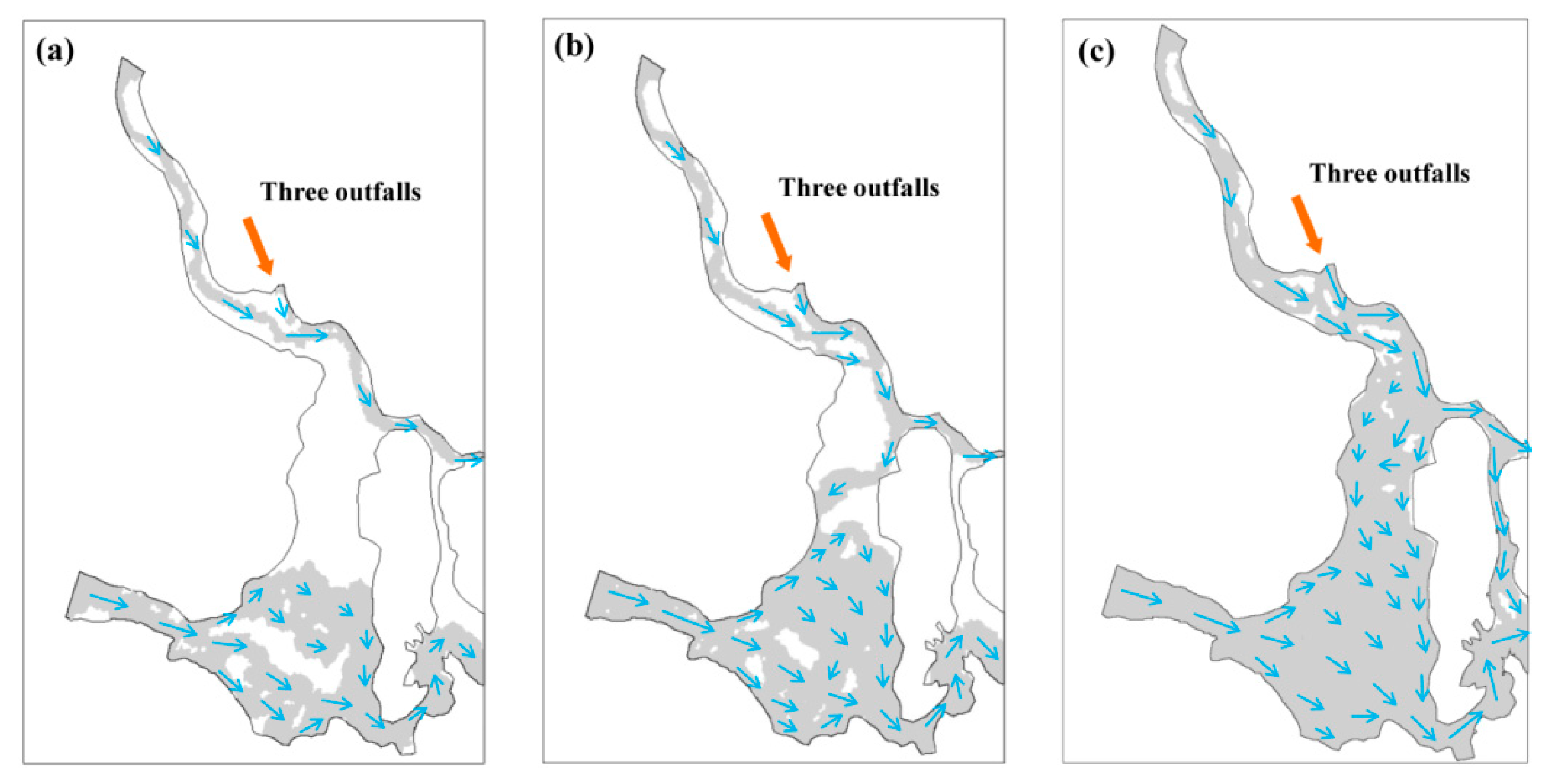
Dongting Lake is a shallow-water tectonic subsidence lake with regular seasonal fluctuations in its water level. The water area of the lake is positively correlated with the changing water level [34], and the lake shows different phases in different periods. With the change in time, the water area gradually increased, and the West Dongting Lake phase changed from the water channels to a continuous water surface (Figure 6). This change was caused by an increase in the water level. The above results are consistent with the research of Jingbao Li et al. When the water level is high in Dongting Lake, the water surfaces of the lake area are connected with each other, showing a lacustrine phase. When the water level is low, the water surface is discontinuous and river-like, which is called the river phase [35].
During the dry season, the inflow rivers flowed to West Dongting Lake with relatively low runoff compared to other periods in the year, and the water level in the lake area was low, which caused the mudflat in West Dongting Lake to be exposed to air [36], while the water surface of the lake area was completely divided into water channels (Figure 6a). In this monitoring period, the flows of the three outfalls and the Lishui River were almost the same (about 240 m3·s−1). Furthermore, the inflowing water masses met in the north of West Dongting Lake and then flowed east directly out of West Dongting Lake through the main water channel. Considering that the ion concentration of S5 was plotted in the middle of the curve (Figure 3a), the water inflowing from the Lishui River and from the three outfalls had a similar degree of influence on S5. The incoming water from the Yuan River flowed out of West Dongting Lake mainly along the south water channel from the west to the east via site S3. Influenced by the shoal in the lake area, the flow velocity of the incoming water of the Yuan River gradually decreased from the main water channel in the south to the shoal in the central part of the lake (Figure 6), showing a gradient change such that only a small amount of the water masses flowed gently to the middle of West Dongting Lake. This indicated that the waters in S3 and S4 were mainly from the Yuan River, so the points representing their tracer ion concentrations were distributed at the lower end of the curve (Figure 3a). During this monitoring period, the total flow of the Yangtze River system to West Dongting Lake was about 800 m3·s−1, higher than that of the Yangtze River system (about 240 m3·s−1). Local rivers were the main water sources for West Dongting Lake during the dry season.
During the normal season, the runoff of the mainstream of the Yangtze River increased gradually. However, since discharge was reduced by the Three Gorges project to meet power generation or flood control needs [37], the discharge from the three outfalls did not significantly increase. At the same time, the Dongting Lake basin entered the rainy season [38], and the local rivers began to enter the main flood season. The amount of water entering the West Dongting Lake, especially from the Yuan River, which had a discharge up to almost 3000 m3·s−1, was largest in this period among all the studied periods [31]. With the increase in water inflows, especially the high-flow water mass from the Yuan River, the hydrodynamic condition of the southern water channel of West Dongting Lake strengthened, the scope of the gentle flow of the Yuan River to the middle of West Dongting Lake increased, and these water masses were connected with a small number of water masses flowing from north to south (Figure 6b). The water area of West Dongting Lake gradually increased, and West Dongting Lake began to transition from the river phase to the lacustrine phase. However, because of spatial differences in water velocity, water masses still flowed out of West Dongting Lake along the main water channel. At the same time, the maximum flow velocity of the incoming water masses from the Lishui River to West Dongting Lake was more than 0.8 m·s−1, and the flow was about 660 m3·s−1, exceeding the values of rivers in the Yangtze River system. This result suggested that the water at the sampling site S5 was mainly affected by the Lishui River. The above phenomenon was consistent with the meaning indicated by the distribution of the ion concentration points of the sampling sites in West Dongting Lake, which were distributed at the lower end of the plotted curve (Figure 3b), indicating that the water body of West Dongting Lake was affected by the local river system during the normal season.
Figure 6.
Hydrodynamic schematic diagram of West Dongting Lake and its inflow rivers in the three study periods. A two-dimensional hydrodynamic model of Dongting Lake [39] was used to simulate the hydrodynamic diagram of West Dongting Lake and its inflow rivers. The gray areas represent the flow scope, the arrows “→” indicate the flow direction and the length of the arrow represent the flow velocity. From left to right, the periods are the dry season (a), the normal season (b), and the wet season (c).

During the wet season, the mainstream of the Yangtze River entered the main flood season, and the discharge from the three outfalls to West Dongting Lake increased greatly. At the same time, the main flood season of the local river system had passed, so that the amount of water entering West Dongting Lake was significantly reduced in the wet season compared to the normal season. However, the total amount of water inflowing from the rivers reached an annual peak [32]. Affected by the substantial increase in the amount of incoming water, most of the shoals in West Dongting Lake were submerged, and the water surface of the lake area was connected from north to south, presenting a lacustrine phase (Figure 6c). Compared with the Lishui River, the high-flow water mass (about 2200 m3·s−1) of the three outfalls had a strong hydrodynamic force and mainly flowed out of West Dongting Lake through the northern water channel, having a greater impact on the water body at sampling site S5 than at other sites. Therefore, the tracer ion concentrations of S5 were very close to those of the Yangtze River system (Figure 3c). The strong hydrodynamic force of the Yangtze River system acting on site S5 weakened the impact of the Lishui River on S5 in the wet season compared to the normal season. During this monitoring period, the inflow volume of the Yuan River to West Dongting Lake decreased but remained as high as about 2100.00 m3·s−1. Except for some water masses flowing slowly to the central part of West Dongting Lake, most of the incoming water was still flowing out of West Dongting Lake at an increased velocity along the southern water channel, indicating that the water body at site S3 was mainly affected by the inflow from the Yuan River. As shown in Figure 3c, the tracer ion concentration of S4 during the wet season was close to that of the Yuan River inflow. However, the water bodies from various sources met in the middle of West Dongting Lake during this period, so it might be a coincidence that the water body of S4 showed similar chemical properties as the incoming water from the Yuan River. Alternatively, a small amount of water from the Yuan River could have accumulated continuously and remained near the site S4 in the dry season and the normal season. Due to the slow flow velocity in the center of West Dongting Lake, these water bodies were not replaced by incoming water from the inflow rivers during the wet season, so it showed similar chemical properties as the water from the Yuan River.
4.2. The Influence of Inflow Water from the Three Outfalls on West Dongting Lake
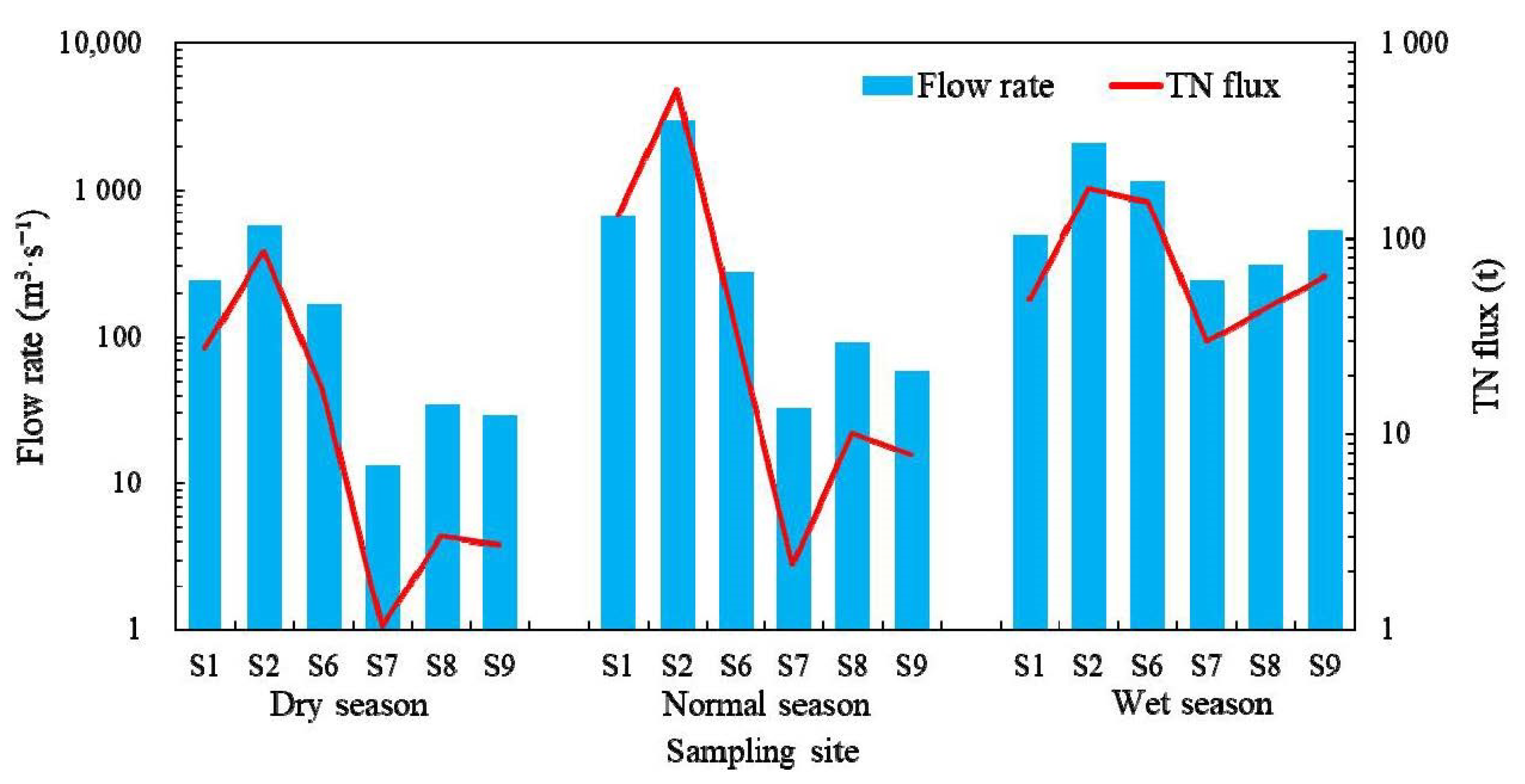
Dongting Lake and the Yangtze River form a river-lake system, linked by rivers formed by outflowing water from three outfalls. The water from these three outfalls flows into the north of West Dongting Lake. The Three Gorges project directly affected the hydrologic process of the interactions between the river and lake [40], leading to changes in the amount of water replenishment and TN input from the Yangtze River system to West Dongting Lake. According to Section 3.3, the contribution of the Yangtze River system’s TN and water to West Dongting Lake is less dominant than that of the local river system’s (the Yuan and Lishui Rivers) TN and water, possibly due to the difference in flow between the Yangtze River system and the local river system. There was a very poor correlation between the TN concentration and flux of the inflow rivers (R2 = 0.3937, p > 0.05), while the correlation between the flow and the TN flux was significant and satisfied the equation y = 0.1635x − 10.603 (R2 = 0.8836). This result indicated that, when there was a large difference in the flow of the inflow rivers, the difference in the TN concentration was no longer the main influencing factor of the TN input.
The water body of the Yangtze River, which is diverged through the three outfalls, flows into West Dongting Lake via Songzi River (west and east branch), Hudu River and Ouchi River. As shown in Figure 7, on the whole, the flow and TN flux from the Yangtze River system to West Dongting Lake increased continuously over the water periods and reached the highest values in the wet season. This was mainly because the mainstream of the Yangtze River was in the main flood season during the wet season, and the discharge of the three outfalls was much higher in the wet season than in the other two seasons. In addition, the upstream area of the Yangtze River is mainly replenished by rainfall [41,42]. During the wet season, the rainfall in the Yangtze River basin was abundant, and rainfall-runoff washed the earth’s surface and carried many nitrogen-containing pollutants (mainly nonpoint sources) from the surface into the river water [43], leading to a significant increase in the pollutant content in the river water. Therefore, the TN concentration of the inflow from the three outfalls was higher in the wet season than in the other water periods. In general, during the wet season, the water replenishment ability of the three outfalls to West Dongting Lake was enhanced, and the TN input of the three outfalls to West Dongting Lake increased significantly.
As shown in Figure 7, there were also differences in the input of water and TN to West Dongting Lake among the three outfalls, and the flow rate and TN flux of the discharge from the Songzi outfall were higher than those of the Taiping and Ouchi outfalls. According to relevant studies, this difference was mainly caused by the influence of the terrain and river regimes around the three outfalls [44,45,46]. The Songzi outfall is located on the riverbank of a section transitioning from a mountain river to a plains river in the mainstream of the Yangtze River, and the riverbed here has a strong scoured resistance. Therefore, the river regime had little impact on flow diversion from the Songzi outfall. The Taiping and Ouchi outfalls are mainly located on the plains river reach. Influenced by sediment scour and deposition, the mainstream of this section shifted northward and far away from the water outfalls, so the flow diversion of the two outfalls decreased. In addition, there were shallow-water areas in the reach near the Taiping and Ouchi outfalls, which was also adverse to flow diversion. Overall, compared with the other two outfalls, Songzi outfall had an advantage in flow diversion from the Yangtze River, especially the west branch of the Songzi River. Due to the large difference in the water flow diversion, the amount of TN transport also changed. Among the three outfalls, the flow diversion of the Songzi outfall contributed the most TN to West Dongting Lake.
4.3. The Influence of Inflow Water from the Local River System on West Dongting Lake
In the local river system, there were large differences in the water flow and TN flux between the Yuan and Lishui Rivers (Figure 7), which indicated that Yuan River may be the main contribution source from the local river system to West Dongting Lake. The Yuan River originates from southern Guizhou Province, China, and flows into West Dongting Lake in Changde City, Hunan Province [47]; its main stream is 1033 km long, and the catchment area is 8.52 × 10⁴ km2 (approximately 5.10 × 10⁴ km2 in Hunan Province). The Lishui River, a river in Hunan Province [48], has a the mainstream that is 388 km long and a catchment area of 1.53 × 10⁴ km2. Because of the large difference in their catchment areas, there are large differences in the flow and pollutant flux between the Yuan and Lishui Rivers, which further influenced the contribution of TN and water from these inflow rivers to West Dongting Lake.
Studies have shown that during the wet season, the catchment area and water flow of the local river system increase greatly. Although there are still pollutant inputs in the river basin, the number of pollutants carried by the water per unit area decreases [49], which has an equivalent impact as the dilution effect. According to Section 4.2, during the wet season, the pollution load of diverted water from the three outfalls increases with the increase in the amount of water. Therefore, in the mass conservation equation of the tracer models, the variation range of the TN contribution rate of the Yangtze River system to West Dongting Lake was larger than that of the water contribution rate, and the variations in the water and TN contributions from the river inflow to West Dongting Lake were not completely synchronized.
According to Section 4.1, influenced by the shoal in the lake area, even though the water bodies from the north and south of West Dongting Lake converge in the normal season and the wet season, the inflowing water masses of the Yuan and Lishui Rivers, respectively, flow out of West Dongting Lake along the main river channel in the south and north. The inflowing water from the Lishui River and the three outfalls meet in the northern waterway of West Dongting Lake, which mainly influences the water body of the northern waterway. Correlation analysis showed that the TN concentration of site S5 did not have a good correlation with the TN concentration of inflow water from the Lishui River and the three outfalls; in fact, the associated correlation coefficients were R2 = 0.59 (p > 0.05) and R2 = 0.66 (p > 0.05), respectively. There were low correlations because neither the Lishui River nor the three outfalls had a sole dominant influence on site S5, and the influences of the two had their own advantages with the change in the water period. Combined with tracer ion concentration, flow rate, and TN flux data, the impacts of inflow water from the Lishui River and the three outfalls on the site S5 were similar during the dry season, the impact of the Lishui River was dominant during the normal season, and the impact of the three outfalls was dominant during the wet season.
Sampling site S3 was located in the southern exit of West Dongting Lake, where the concentrations of TN (R2 = 0.961, p < 0.01) and tracer ions (Na: R2 = 0.999, p < 0.01; Cl: R2 = 0.995, p < 0.01) were very significantly correlated with the TN and ion concentrations of inflow water from the Yuan River and were poorly correlated with the TN and ion concentrations of inflow water from the Lishui River and the three outfalls (R2 values were all less than 0.5). These results indicate that the chemical characteristics of the water body near site S5 were very similar to those of the Yuan River, and the TN concentration was significantly affected by the load input of the Yuan River. This was mutually confirmed with the water replenishment of West Dongting Lake by the Yuan River. The inflow water of the Yuan River flowed mainly along the south water channel and out of West Dongting Lake via site S3 and was the main source of water to the area of site S3.
Site S4 was located in the center of West Dongting Lake, where the tracer ion concentration of the water body was significantly correlated with that of inflow water from the Yuan River (Na: R2 = 0.887, p < 0.05; Cl: R2 = 0.981, p < 0.05) and the TN concentration of the water body had a general correlation with that of inflow water from the Yuan River (R2 = 0.442, p > 0.05). However, the concentrations of tracer ions and TN at site S4 were weakly correlated with the tracer ion and TN concentrations of inflow water from the Lishui River and the three outfalls (R2 were all less than 0.1). The chemical properties of the water of site S4 were similar to those of the Yuan River. Furthermore, the effect of the TN input from the local river system and the Yangtze River system on the TN concentration at site S4 was not obvious, but the influence of the Yuan River was relatively high. The TN concentrations of site S4 were 0.88 mg·L−1 in the dry season, 1.43 mg·L−1 in the normal season and 1.74 mg·L−1 in the wet season. The gradual increase in TN concentration over the three periods indicated a gradual accumulation of TN at site S4. This accumulation was related to the fact that site S4 was located in the center of West Dongting Lake. In addition to the influence of the shoal, the incoming water masses from the rivers flowed slowly toward the center of West Dongting Lake when the hydrodynamic was gradually weakened, resulting in water masses with a slow flow velocity and a weak hydrodynamic force and the consequentially easy accumulation of pollutants. Therefore, the replenishment of water from the Yuan River in the dry season and the normal season accumulated and remained at site S4, and it was difficult for these waters to be replaced by the inflowing water here in the wet season. On the whole, during the wet season, the center of West Dongting Lake showed similar chemical characteristics as water from the Yuan River.
5. Conclusions
The two-source mixing model and the two-component TN mixing model were combined to study the contribution characteristics of the water and TN from inflow rivers to West Dongting Lake based on the law of mass conservation. Na+ and Cl− were suitable tracer ions selected by analyzing the correlations and differences of ion concentrations. The model calculation results showed that the contribution rates of the water and TN from the local river system to West Dongting Lake were higher than these from the Yangtze River system to West Dongting Lake in three water periods. The Yuan River in the local river system was the largest source of the water and TN of West Dongting Lake. The contributions of the water and TN from Songzi outfall to West Dongting Lake were higher than those from the other two outfalls in the Yangtze River system. Although water masses in the local river system during the wet season had a dilution effect on pollutant concentration, which affected the change consistency of the contribution rates of water and TN, the results of the tracing models could almost accurately reflect the contribution variation in water and TN from different sources to West Dongting Lake. This indicated that major ion tracing is feasible in lake connected with big rivers.
Dongting Lake is a type of channel-like lake. From the dry season to the wet season, West Dongting Lake has undergone changes in river phases (the water surface was completely divided), river-lake transition states (the water surface was gradually connected) and lacustrine phases (the water surface was completely connected). Affecteding by the shoal in the lake area, the inflow water from the three outfalls and Lishui River converged in the northern part of West Dongting Lake and flowed out of West Dongting Lake mainly through the north water channel. The inflow water from the Yuan River flowed into the southern part of West Dongting Lake and flowed out of West Dongting Lake mainly through the south water channel. The water body in the center of West Dongting Lake was replenished by the Yuan River during the dry season and the normal season, while this water body was replenished by all the rivers in the local river system and the Yangtze River system during the wet season. However, due to the slow flow velocity and replacement speed of water in the West Dongting Lake center, the chemical characteristics of the water body here were similar to those of the Yuan River during the wet season.
According to this study, some conclusions are also drawn. Not all ions are suitable for ion tracing studies. Tracer ions should have chemically conservative characteristics in water, which are not easy to be enriched and deposited, and the concentration of tracer ions should have a stable concentration difference between different sources of water. The study also showed that the input from the local river system is the largest source in the inflow rivers of West Dongting Lake, among which Yuan River contributes the most. It suggests that the relevant departments should prioritize the control of pollutant input from Yuan River to West Dongting Lake, especially focusing on the input during the normal season. Furthermore, although the nitrogen pollutant input from the Yangtze River recharge through the three outfalls to West Dongting Lake was not dominant among all the inflow river inputs, it is still necessary to focus on the diversion of inflow from the Songzi outfall, especially during the wet season.
Author Contributions
Conceptualization, Y.L. and L.W.; methodology, Y.L.; software, Y.L. and Z.T.; validation, Y.L. and Z.T.; formal analysis, Y.L.; investigation, Y.L., H.L. and Z.T.; resources, L.W.; data curation, Y.L. and H.L.; writing—original draft preparation, Y.L.; writing—review and editing, Y.L. and L.W.; visualization, Y.L. and Z.T.; supervision, L.W.; project administration, H.L.; funding acquisition, L.W. All authors have read and agreed to the published version of the manuscript.
Funding
This research is funded by Lijing Wang. Funding projects are the National Science Fund for Distinguished Young Scholars of China (grant number 51609225), the Follow-up Work Project of the Three Gorges (grant number 2017HXXY-05), and the National Key Technologies Research and Development Program of China (grant number 2017YFC0404702).
Data Availability Statement
The datasets used and/or analyzed during the current study are available from the corresponding author on reasonable request.
Acknowledgments
The authors acknowledge the support provided by Midstream Bureau of Hydrology Bureau of Changjiang Water Resources Commission. We are very grateful to the reviewers for their constructive comments to help improve the previous manuscript.
Conflicts of Interest
The authors declare that they have no competing interest.
References
- Kelly, V.J. Influence of reservoirs on solute transport: A regional-scale approach. Hydrol. Process. 2001, 15, 1227–1249. [Google Scholar] [CrossRef]
- Jarvie, H.P.; Neal, C.; Leach, D.V.; Ryland, G.P.; House, W.A.; Robson, A.J. Major ion concentrations and the inorganic carbon chemistry of the Humber rivers. Sci. Total Environ. 1997, 194–195, 285–302. [Google Scholar] [CrossRef]
- Bien, G.S.; Contois, D.E.; Thomas, W.H. The removal of soluble silica from fresh water entering the sea. Geochim. Cosmochim. Acta 1958, 14, 35–54. [Google Scholar] [CrossRef]
- Liss, P.S.; Spencer, C.P. Abiological processes in the removal of silicate from sea water. Geochim. Cosmochim. Acta 1970, 34, 1073–1088. [Google Scholar] [CrossRef]
- Liss, P.S.; Pointon, M.J. Removal of dissolved boron and silicon during estuarine mixing of sea and river waters. Geochim. Cosmochim. Acta 1973, 37, 1493–1498. [Google Scholar] [CrossRef]
- Zhang, J. Some progresses in estuarine geochemical studies of China. Oceanol. Limnol. Sin. 1994, 25, 438–445. [Google Scholar]
- Yang, L.; Liu, D.F.; Yang, Z.J.; Li, Y.; Zhang, P. Density-stratified flow of Xiangxi Bay at Three Gorges Reservoir based on the tracer principle of inorganic ion. Resour. Environ. Yangtze Basin 2015, 24, 278–285. [Google Scholar]
- Chen, Y.Y.; Liu, D.F.; Yang, Z.J.; Wang, Y.C.; Ji, D.B.; Zhang, P.; Li, Y. The impacts of the stratified density currents on supply pattern of main nutrients in Xiangxi River. Acta Scien. Circum. 2013, 33, 762–770. [Google Scholar]
- Zhao, Y.Y.; Zheng, B.H.; Wang, L.J.; Qin, Y.W.; Li, H.; Cao, W. Characterization of mixing processes in the confluence zone between the Three Gorges reservoir mainstream and the Daning River using stable isotope analysis. Environ. Sci. Technol. 2016, 50, 9907–9914. [Google Scholar] [CrossRef]
- Wang, W.F.; Yuan, W.K.; Chen, Y.L.; Wang, J. Microplastics in surface waters of Dongting Lake and Hong Lake, China. Sci. Total Environ. 2018, 633, 539–545. [Google Scholar] [CrossRef]
- Yin, H.F.; Liu, G.R.; Pi, J.G.; Chen, G.J.; Li, C.A. On the river–lake relationship of the middle Yangtze reaches. Geomorphology 2007, 85, 197–207. [Google Scholar] [CrossRef]
- Lai, X.J.; Wang, Z.M. Flood management of Dongting Lake after operation of Three Gorges Dam. Water Sci. Eng. 2017, 10, 303–310. [Google Scholar] [CrossRef]
- Lin, R.P.; Ni, Z.K.; Guo, S.K.; Gong, J.J.; Wang, S.R. The trend and downside risk of water quality ecolution in Dongting Lake in recent 25 years. China Environ. Sci. 2018, 38, 4636–4643. [Google Scholar]
- Xiong, J.; Yu, F.Q.; Tian, Q.; Huang, D.Z.; Li, L.Q. The evolution of water quality and nutrient condition in Lake Dongting in recent 30 years. J. Lake Sci. 2016, 28, 1217–1225. [Google Scholar]
- Cui, M.; Zhou, J.X.; Huang, B. Benefit evaluation of wetlands resource with different modes of protection and utilization in the Dongting Llake region. Procedia Environ. Sci. 2012, 13, 2–17. [Google Scholar] [CrossRef]
- Tian, Z.B.; Zheng, B.H.; Wang, L.J.; Li, H.; Wang, X. Effects of river-lake interactions in water and sediment on phosphorus in Dongting Lake, China. Environ. Sci. Poll. Res. 2017, 24, 23250–23260. [Google Scholar] [CrossRef]
- Yu, Y.W.; Mei, X.F.; Dai, Z.J.; Gao, J.J.; Li, J.B.; Wang, J.; Lou, Y.Y. Hydromorphological processes of Dongting Lake in China between 1951 and 2014. J. Hydrol. 2018, 562, 254–266. [Google Scholar] [CrossRef]
- SEPA (State Environmental Protection Administration). Methods for Monitoring and Analyzing Water and Wastewater, 4th ed.; China Environmental Science Press: Beijing, China, 2002; pp. 254–258. (In Chinese) [Google Scholar]
- Hunan Hydrological Network. Available online: http://yzt.hnswkcj.com:9090/#/ (accessed on 20 March 2022).
- Yang, Z.J. The Mechanisms of Algal Blooms and Its Operation Method through Water Level Fluctuation under the Situation of the Bidirectional Density Currents in Tributaries of the Three Gorges Reservoir. Ph.D. Thesis, Wuhan University, Wuhan, China, 2014. [Google Scholar]
- Jarvie, H.P.; Neal, C.; Tappin, A.D.; Burton, J.D.; Hill, L.; Neal, M.; Harrow, M.; Hopkins, R.; Watts, C.; Wickham, H. Riverine inputs of major ions and trace elements to the tidal reaches of the River Tweed, UK. Sci. Total Environ. 2000, 251–252, 55–81. [Google Scholar] [CrossRef]
- Huang, Y.M.; Song, X.F.; Zhang, X.P.; He, Q.H.; Han, Q.; Fan, F.D.; He, W. Stable water isotopes of different water bodies in the Dongting Lake Basin. Scien. Geogr. Sin. 2016, 36, 1252–1260. [Google Scholar]
- Zhan, L.C.; Chen, J.S.; Zhang, S.Y. Characteristics of stable isotopes in precipition, surface water and groundwater in the Dongting Lake region. Adv. Water Sci. 2014, 25, 327–335. [Google Scholar]
- Bu, Y.X.; Su, S.M. Balance analysis of nitrogen and phosphorus detained in Dongting Lake. Yangtze River 2002, 33, 23–25. [Google Scholar]
- Liu, X.J.; Yu, Z.M.; Song, X.X.; Cao, X.H. The nitrogen isotopic composition of dissolved nitrate in the Yangtze River (Changjiang) estuary, China. Estuar. Coast. Shelf Sci. 2009, 85, 641–650. [Google Scholar] [CrossRef]
- Phillips, D.L.; Gregg, J.W. Uncertainty in source partitioning using stable isotopes. Oecologia 2001, 127, 171–179. [Google Scholar] [CrossRef]
- Altier, A.; Jiménez-Piedrahita, M.; Uribe, R.; Rey-Castro, C.; Galceran, J.; Puy, J. Time weighted average concentrations measured with diffusive gradients in thin films (DGT). Analyt. Chim. Acta 2019, 1060, 114–124. [Google Scholar] [CrossRef]
- Wang, T.; Wang, L.; Chen, Q.Q.; Kalogerakis, N.; Ma, Y. Interactions between microplastics and organic pollutants: Effects on toxicity, bioaccumulation, degradation, and transport. Sci. Total Environ. 2020, 748, 142427. [Google Scholar] [CrossRef]
- Gu, W.Z.; Lu, J.J.; Zhao, X.; Peters, N.E. Responses of hydrochemical inorganic ions in the rainfall-runoff processes of the experimental catchments and its significance for tracing. Adv. Water Sci. 2007, 18, 1–7. [Google Scholar]
- Ran, X.B.; Yu, Z.G.; Yao, Q.Z.; Chen, H.T.; Mi, T.Z. Major ion geochemistry and nutrient behaviour in the mixing zone of the Changjiang (Yangtze) river and its tributaries in the Three GorgesReservoir. Hydrol. Process. 2010, 24, 2481–2495. [Google Scholar] [CrossRef]
- Ou, C.M.; Li, J.B.; Zhou, Y.Q.; Cheng, W.Y.; Yang, Y.; Zhao, Z.H. Evolution characters of water exchange abilities between Dongting Lake and Yangtze River. J. Geogr. Sci. 2014, 24, 731–745. [Google Scholar] [CrossRef] [Green Version]
- Li, J.B.; Zhou, Y.Q.; Ou, C.M.; Cheng, W.Y.; Yang, Y.; Zhao, Z.H. Evolution of water exchange ability between Dongting Lake and Yangtze River and its response to the operation of the Three Gorges Reservoir. Acta Geogr. Sin. 2013, 68, 108–117. [Google Scholar]
- Tian, Z.B.; Zheng, B.H.; Wang, L.J.; Li, L.Q.; Wang, X.; Li, H.; Norra, S. Long term (1997–2014) spatial and temporal variations in nitrogen in Dongting Lake, China. PLoS ONE 2017, 12, e0170993. [Google Scholar] [CrossRef]
- Ding, X.W.; Li, X.F. Monitoring of the water-area variations of Lake Dongting in China with envisat asar images. Int. J. Appl. Earth Obs. 2011, 13, 894–901. [Google Scholar] [CrossRef]
- Gao, Y.; Xie, Y.H.; Zou, D.S. Hydrological regime change and its ecological responses in East Dongting Lake, China. Ecohydrol. Hydrobiol. 2020, 20, 142–150. [Google Scholar] [CrossRef]
- Lai, X.J.; Huang, Q.; Jiang, J.H. Wetland inundation modeling of Dongting Lake using two-dimensional hydrodynamic model on unstructured grids. Procedia Environ. Sci. 2012, 13, 1091–1098. [Google Scholar] [CrossRef] [Green Version]
- Qin, P.C.; Xu, H.M.; Liu, M.; Du, L.M.; Xiao, C.; Liu, L.L.; Tarroja, B. Climate change impacts on Three Gorges Reservoir impoundment and hydropower generation. J. Hydrol. 2019, 580, 123922. [Google Scholar] [CrossRef]
- Wang, Y.M.; Li, Z.W.; Tang, Z.H.; Zeng, G.M. A GIS-Based Spatial Multi-Criteria Approach for Flood Risk Assessment in the Dongting Lake Region, Hunan, Central China. Water Resour. Manag. 2011, 25, 3465–3484. [Google Scholar] [CrossRef]
- Tian, Z.B.; Wang, L.J.; Zheng, B.H.; Li, X.B. Impact simulation of the Chenglingji hydraulic project on hydrodynamics of Dongting Lake. Acta Scien. Circum. 2016, 36, 1883–1890. [Google Scholar]
- Zhou, Y.Q.; Ma, J.R.; Zhang, Y.L.; Li, J.B.; Feng, L.; Zhang, Y.B.; Shi, K.; Brookes, J.D.; Jeppesen, E. Influence of the three gorges reservoir on the shrinkage of China’s two largest freshwater lakes. Glob. Planet Change 2019, 177, 45–55. [Google Scholar] [CrossRef]
- Chen, J.; Wu, X.D.; Finlayson, B.L.; Webber, M.; Wei, T.Y.; Li, M.T.; Chen, Z.Y. Variability and trend in the hydrology of the Yangtze River, China: Annual precipitation and runoff. J. Hydrol. 2014, 513, 403–412. [Google Scholar] [CrossRef]
- Chen, C.; Finlayson, B.L.; Wei, T.Y.; Sun, Q.L.; Webber, M.; Li, M.T.; Chen, Z.Y. Changes in monthly flows in the Yangtze River, China-With special reference to the Three Gorges Dam. J. Hydrol. 2016, 536, 293–301. [Google Scholar] [CrossRef]
- Wang, C.R.; Li, H.; Yuan, X.P. Temporal-spatial distribution of nitrogen and phosphorus in fishery waters of the Dognting Lake. Resour. Environ. Yangtze Basin 2013, 22, 928–936. [Google Scholar]
- Wang, X.Y.; Li, X.; Wu, Y.H. Maintaining the connected river-lake relationship in the middle Yangtze River reaches after completion of the Three Gorges Project. Int. J. Sediment Res. 2017, 32, 487–494. [Google Scholar] [CrossRef]
- Huang, H.L.; Xiao, H.C. Water diversion evolution tendency of the Songzi River. Yangtze River 2007, 38, 43–46. [Google Scholar]
- Dou, S.T.; Yu, M.H.; Duan, W.Z.; Liu, X.F. Study on flow and sediment load and preliminary proposal in five tributaries of Jingjiang River. Eng. J. Wuhan Univ. 2007, 40, 40–44. [Google Scholar]
- Fang, X.H.; Peng, B.; Zhang, K.; Zeng, D.Z.; Kuang, X.L.; Wu, B.J.; Tan, C.Y.; Wang, X. Heavy metal contamination of bed sediments in inlet area of the lowermost Yuanjiang River, Hunan province of China. Geogr. Res. 2016, 35, 1887–1898. [Google Scholar]
- Sun, G.X.; Wang, X.J.; Hu, Q.H. Using stable lead isotopes to trace heavy metal contamination sources in sediments of Xiangjiang and Lishui Rivers in China. Environ. Poll. 2011, 159, 3406–3410. [Google Scholar] [CrossRef] [PubMed]
- Li, J.B. Research on ion flow and chemical denudation in river system of Dongting Lake. Scien. Geogr. Sin. 1989, 9, 242–251. [Google Scholar]
Figure 1.
Map of the study area and water sampling site.

Figure 2.
Correlation matrix arrangement of the major ion concentrations of water samples in the study area. Each red ellipse indicates a 95% confidence interval.
Figure 2.
Correlation matrix arrangement of the major ion concentrations of water samples in the study area. Each red ellipse indicates a 95% confidence interval.

Figure 3.
The correspondence relations of the concentrations of Na+ and Cl− in the dry season (a), in the normal season (b) and in the wet season (c), respectively.
Figure 3.
The correspondence relations of the concentrations of Na+ and Cl− in the dry season (a), in the normal season (b) and in the wet season (c), respectively.

Figure 4.
Spatiotemporal distribution of the concentrations of Na+ and Cl− in the dry season (a), in the normal season (b) and in the wet season (c), respectively. In the legend, the length of the green bar represents the unit length.
Figure 4.
Spatiotemporal distribution of the concentrations of Na+ and Cl− in the dry season (a), in the normal season (b) and in the wet season (c), respectively. In the legend, the length of the green bar represents the unit length.

Figure 5.
Spatiotemporal distribution of TN concentration in three periods. In the legend, the length of the red bar represents the unit length, whose value is 1.2 mg·L−1.
Figure 5.
Spatiotemporal distribution of TN concentration in three periods. In the legend, the length of the red bar represents the unit length, whose value is 1.2 mg·L−1.

Figure 7.
Flow rates and TN fluxes of the sampling sites in the Yangtze River system and the local river system during the three monitoring periods.
Figure 7.
Flow rates and TN fluxes of the sampling sites in the Yangtze River system and the local river system during the three monitoring periods.


Table 1.
Basic information on sampling sites located in West Dongting Lake and its inflow rivers.
| Spatial Group | Sites | Basic Information |
|---|---|---|
| Local rivers | S1 | Located on the mainstream before the tributary flows into West Dongting Lake, representing the water quality of the Li River. |
| S2 | Located in the Yuan River estuary, representing the water quality of the Yuan River. | |
| West Dongting Lake | S3 | Located in the south outlet of West Dongting Lake. |
| S4 | The central area of West Dongting Lake. | |
| S5 | Located in the confluence of inflow from the Li River and the three outfalls of the Yangtze River. | |
| Three outfalls | S6 | Located in the west branch of Songzi River, representing the water quality of the flow from the Songzi outfall of the Yangtze River. |
| S7 | Located in the east branch of Songzi River, representing the water quality of the flow from the Songzi outfall of the Yangtze River. | |
| S8 | Located in the Hudu River estuary, representing the water quality of the flow from the Taiping outfall of the Yangtze River. | |
| S9 | Located in the Ouchi River estuary, representing the water quality of the flow from the Ouchi outfall of the Yangtze River. |
Table 2.
The correlation coefficients of the major ions of water samples in the study area, n = 27.
| Ca2+ | Na+ | Mg2+ | F− | Cl− | ||
| K+ | 0.692 ** | 0.714 ** | 0.577 ** | 0.443 * | −0.001 | 0.662 ** |
| Ca2+ | 0.861 ** | 0.760 ** | 0.700 ** | −0.099 | 0.833 ** | |
| Na+ | 0.645 ** | 0.876 ** | −0.235 | 0.982 ** | ||
| Mg2+ | 0.398 * | −0.149 | 0.543 ** | |||
| −0.214 | 0.923 ** | |||||
| F− | −0.188 |
Note: * stands for p < 0.05, ** stands for p < 0.01.
Table 3.
Concentrations of major ions and the differences between the local river system and the Yangtze River system.
Table 3.
Concentrations of major ions and the differences between the local river system and the Yangtze River system.
| Time | Item | K+ | Ca2+ | Na+ | Mg2+ | Cl− | |
|---|---|---|---|---|---|---|---|
| December 2016 (the dry season) | Concentration in the Yangtze River system(mg·L−1) | 2.760 | 48.237 | 11.568 | 9.471 | 38.432 | 15.782 |
| Concentration in the local river system (mg·L−1) | 2.060 | 34.671 | 3.497 | 6.509 | 21.797 | 5.303 | |
| Concentration difference (mg·L−1) | 0.700 | 13.567 | 8.070 | 2.962 | 16.635 | 10.478 | |
| Difference rate (%) | 25.36 | 28.12 | 69.77 | 31.28 | 43.28 | 66.39 | |
| April 2017 (the normal season) | Concentration in the Yangtze River system (mg·L−1) | 3.397 | 59.232 | 17.109 | 15.386 | 44.655 | 22.469 |
| Concentration in the local river system (mg·L−1) | 1.526 | 36.494 | 3.189 | 7.683 | 25.541 | 3.694 | |
| Concentration difference (mg·L−1) | 1.871 | 22.738 | 13.920 | 7.703 | 19.114 | 18.776 | |
| Difference rate (%) | 55.08 | 38.39 | 81.36 | 50.06 | 42.80 | 83.56 | |
| August 2017 (the wet season) | Concentration in the Yangtze River system (mg·L−1) | 2.448 | 47.048 | 10.597 | 8.882 | 38.685 | 15.158 |
| Concentration in the local river system (mg·L−1) | 1.675 | 30.633 | 2.636 | 5.394 | 19.289 | 3.748 | |
| Concentration difference (mg·L−1) | 0.772 | 16.415 | 7.961 | 3.488 | 19.397 | 11.410 | |
| Difference rate (%) | 31.55 | 34.89 | 75.13 | 39.27 | 50.14 | 75.27 |
Table 4.
Contribution rates of water and TN from the local river system and from the Yangtze River system to West Dongting Lake, %.
Table 4.
Contribution rates of water and TN from the local river system and from the Yangtze River system to West Dongting Lake, %.
| Time | Source | Water Contribution Rate | TN Contribution Rate | ||
|---|---|---|---|---|---|
| Cl− | Na+ | Cl− | Na+ | ||
| December 2016 (the dry season) | the Yangtze River system | 23.46 | 17.57 | 17.81 | 13.09 |
| the local river system | 76.54 | 82.43 | 82.19 | 86.91 | |
| estimated deviation | 14.89 | 16.57 | |||
| April 2017 (the normal season) | the Yangtze River system | 7.55 | 2.04 | 5.77 | 1.54 |
| the local river system | 92.45 | 97.96 | 94.23 | 98.46 | |
| estimated deviation | 11.30 | 12.50 | |||
| August 2017 (the wet season) | the Yangtze River system | 27.42 | 28.37 | 36.01 | 37.11 |
| the local river system | 72.58 | 71.63 | 63.99 | 62.89 | |
| estimated deviation | −14.88 | −14.50 | |||
Publisher’s Note: MDPI stays neutral with regard to jurisdictional claims in published maps and institutional affiliations. |
© 2022 by the authors. Licensee MDPI, Basel, Switzerland. This article is an open access article distributed under the terms and conditions of the Creative Commons Attribution (CC BY) license (https://creativecommons.org/licenses/by/4.0/).
Share and Cite
MDPI and ACS Style
Li, Y.; Wang, L.; Tian, Z.; Li, H. Characterization of Water and Total Nitrogen Contributions from the Inflow Rivers to Lake: A Study of West Dongting Lake in China. Water 2022, 14, 3463. https://doi.org/10.3390/w14213463
AMA Style
Li Y, Wang L, Tian Z, Li H. Characterization of Water and Total Nitrogen Contributions from the Inflow Rivers to Lake: A Study of West Dongting Lake in China. Water. 2022; 14(21):3463. https://doi.org/10.3390/w14213463
Chicago/Turabian StyleLi, Yingjie, Lijing Wang, Zebin Tian, and Hong Li. 2022. "Characterization of Water and Total Nitrogen Contributions from the Inflow Rivers to Lake: A Study of West Dongting Lake in China" Water 14, no. 21: 3463. https://doi.org/10.3390/w14213463
Note that from the first issue of 2016, this journal uses article numbers instead of page numbers. See further details here.