Article

Rapid Response of Runoff Carrying Nitrogen Loss to Extreme Rainfall in Gentle Slope Farmland in the Karst Area of SW China

1
College of Forestry, Guizhou University, Guiyang 550025, China
2
Institute of Soil Erosion and Ecological Restoration, Guizhou University, Guiyang 550025, China
3
Guizhou State-Owned Longli Forest Farm in Guizhou Province, Longli 551200, China
*
Author to whom correspondence should be addressed.
Water 2022, 14(20), 3341; https://doi.org/10.3390/w14203341
Submission received: 7 September 2022 / Revised: 15 October 2022 / Accepted: 17 October 2022 / Published: 21 October 2022
(This article belongs to the Section Hydrology)

Abstract

:
Nitrogen loss is the main reason for land quality degradation and productivity decline and an important factor in groundwater pollution. Extreme rainfall has occurred frequently in Karst areas of southwest China in recent years. It is of great significance to study the response of soil nitrogen loss to extreme rainfall in Karst areas to prevent and treat land quality degradation and non-point source pollution. In this study, field monitoring and indoor artificial rainfall simulation were used to study the loss characteristics of total soil nitrogen (TN), ammonium (NH4+-N) nitrogen, and nitrate-nitrogen (NO3-N) in Karst bare slope farmland (slope angles of 5° and 10°) under extreme rainfall conditions. The results showed that: (1) Extreme rainfall (90 mm/h) increased the surface runoff, middle soil runoff, and underground runoff by 1.68 times, 1.16 times, and 1.43 times, respectively, compared with moderate rainfall (60 mm/h), so that nitrogen loss increased with runoff. (2) The loss of nitrate-nitrogen in surface, soil, and underground under extreme rainfall conditions was 223.99, 147.93, and 174.02% higher than that under moderate rainfall conditions, respectively; the nitrate losses were 203.78, 160.18, and 195.39% higher, respectively. Total nitrogen losses were 187.33, 115.45, and 138.68% higher, respectively. (3) The influencing factors of total soil nitrogen and nitrate-nitrogen loss in Karst slope farmland were slope > rainfall duration > rainfall intensity, while the influencing factors of ammonium nitrogen loss were rainfall duration > slope > rainfall intensity. Therefore, in controlling nitrogen loss in Karst slope farmland, changing slope degree and increasing farmland coverage may be useful measures to slow the nitrogen loss caused by extreme rainfall.

1. Introduction

Global environmental change is a significant and urgent ecological problem facing humanity [1,2]. The biochemical process of nitrogen on the Earth’s surface and its environmental effects are significant in regional research on global change [3]. Driven by natural and anthropogenic factors, soil nitrogen is one of the essential nutrients and pollution sources in agriculture, ecology, and environmental management [4]. For example, nitrogen loss not only results in a decrease in soil fertility and land productivity [5], but also causes eutrophication of water bodies, which can damage the ecological environment [6]. Nitrogen in soil mainly exists in the form of organic nitrogen and inorganic nitrogen [7]. The nitrogen crops use is mainly in the forms of ammonium nitrogen and nitrate-nitrogen [8]. In recent decades, fertilization and tillage have greatly accelerated soil nitrogen loss in sloping farmland, directly reducing crop nitrogen uptake and reducing crop yield [9]. In particular, global warming has led to extreme precipitation in Karst areas, resulting in severe soil erosion and increased rocky desertification [10].
The southwestern Karst area centered in Guizhou Province, China, is a specific ecologically fragile area and is the most concentrated and strongly developed area of Karst landforms in the world [11,12]. Due to the unique topography and climate conditions in this area, the soil formation rate is slow, the rock exposure rate is high, the soil is shallow, the ground is discontinuous, and the soil erosion is severe, resulting in poor soil and low productivity of cultivated land in this area [13]; on the other hand, due to the Karst formation process, the Karst area has formed a unique surface–underground “dual spatial structure” [14]. In addition to surface soil erosion, underground Karst pipelines (shafts, water holes and underground holes (fissures), etc.) also lose soil and water [15,16], resulting in the loss of soil nitrogen to Karst aquifers [17], which eventually leads to the contamination of groundwater sources in Karst areas [18]. Global climate change causes frequent extreme rainfall events in Karst areas. Rainfall shows an increasing trend, and the damage index caused by extreme rain to soil and water loss of Karst slope farmland also indicates a growing trend [19,20]. Currently, many domestic and foreign research studies report on the influence of rainfall intensity on slope soil nutrient loss [21,22,23,24,25,26,27], but the research on soil nitrogen loss on Karst slope farmland with unique surface–underground dual spatial structure is still blank.
Therefore, in this study, we used customized steel grooves to simulate the dual structure of Karst slopes. The effects of rainfall intensity and slope gradient on soil nitrogen loss were studied with simulated rainfall. The primary purposes of this study are as follows: (1) To explore the ammonium, nitrate, and total nitrogen in the soil of gentle slope farmland in Karst areas under extreme rainfall conditions and determine whether surface loss is greater than underground loss.(2) Use multiple regression analysis and correlation analysis to determine whether the nitrogen loss of Karst gentle slope farmland is related to rainfall intensity, slope angle, and rainfall duration. This study provides a new perspective on the response of nitrogen loss to extreme rainfall events in gentle slope farmland in the Karst area. It gives a scientific basis for preventing and controlling nitrogen loss due to extreme precipitation events.

2. Materials and Methods

2.1. Field Investigation and Monitoring Test

Huaxi District of Guizhou Province has the characteristics of a plateau monsoon humid climate: mild winters and summers, a long frost-free period, abundant rainfall, and high humidity. The average annual temperature is 14.9 °C, the average frost-free period is 246 days, and the annual rainfall is 1178.3 mm, mainly concentrated in May–October.
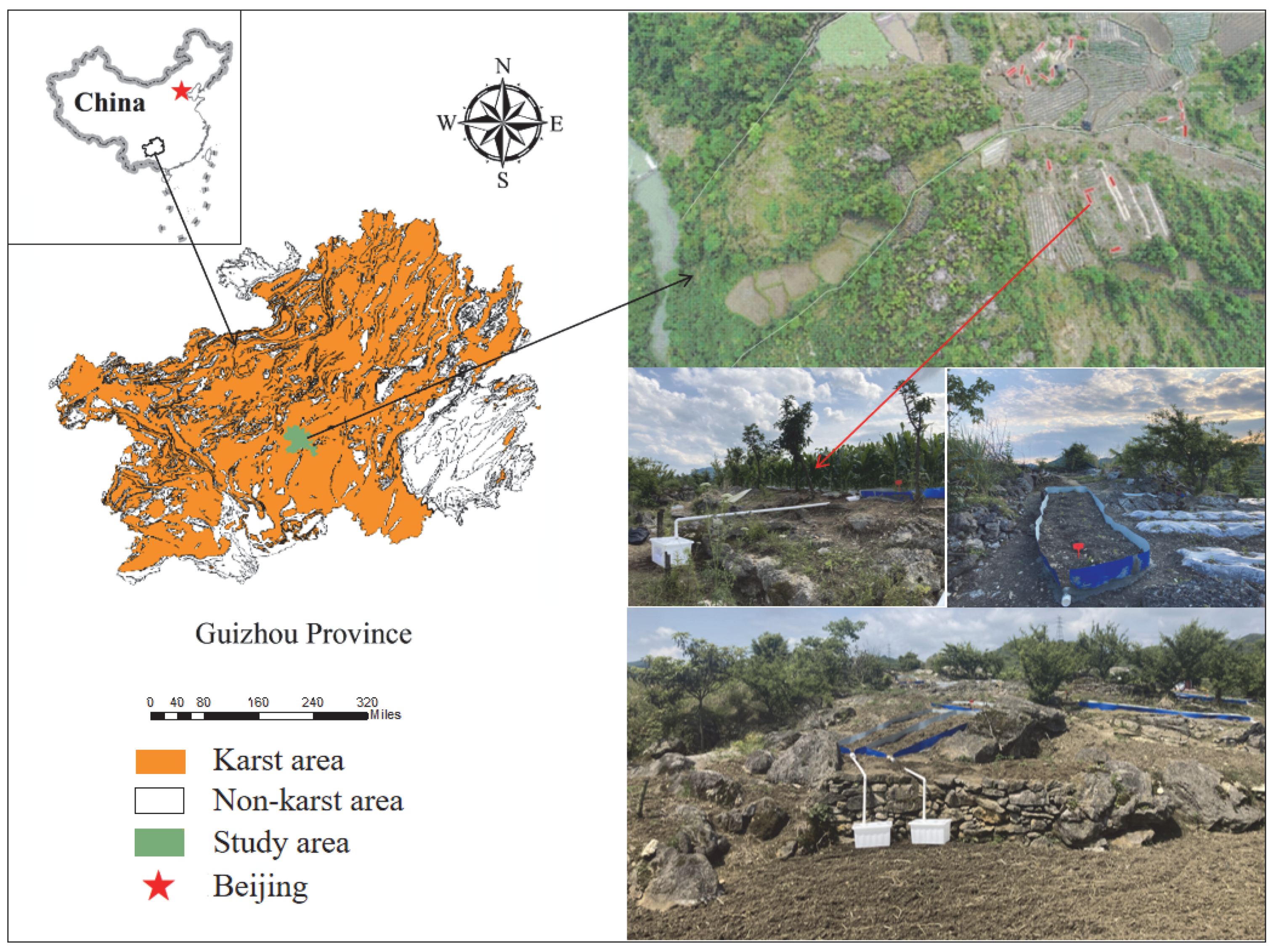
Our research group deployed 18 runoff plots (5 m × 1 m) and a set of meteorological monitoring systems on sloping farmland in the Dazhai small watershed, Huaxi District, Guizhou Province, China (Figure 1). Farmers have used the sloping fields to plant corn, tomatoes, peppers, eggplants, or carrots for more than 20 years; the soil depth is about 30 cm downhill and 20 cm uphill. By monitoring the surface runoff during rain, we found that when the rainfall intensity is 30 mm/h, most of the water infiltrates the slope farmland soil, resulting in very little surface runoff; when the rainfall intensity is between 50 mm/h and 120 mm/h, surface runoff will occur due to the slope difference. The distribution of surface catchment in this area is uneven, and the difference between the upper and middle slopes is significant. The contrast of shallow Karst pores (fissures) may be one of the reasons for the difference in surface runoff. Based on the previous literature statistics, there are underground pores (cracks) in the Karst area, and the groundwater hydrological system in the study area is relatively developed [16,28,
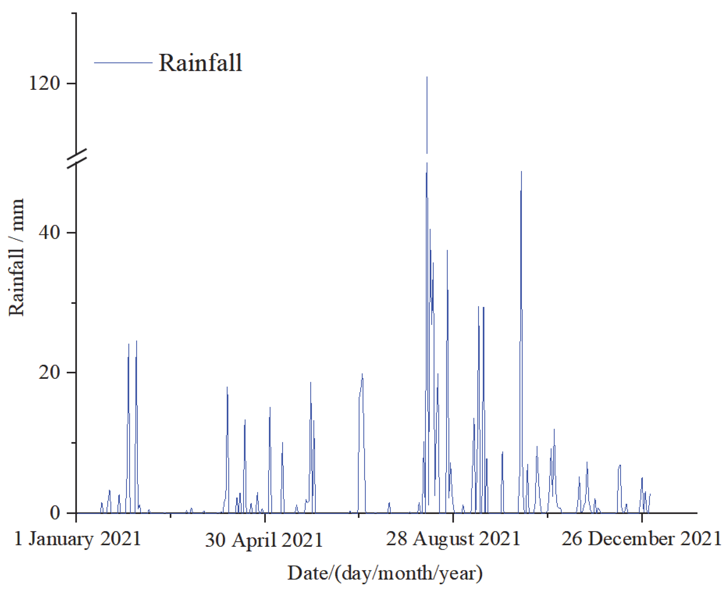
29]. Therefore, in our experimental design, the fracture degree of underground pores was set to 5%. The preliminary analysis of the monitoring data in this area showed that erosion precipitation in 2021 was mainly distributed from August to October (Figure 2). Under heavy rain, the runoff and sediment in the runoff plot are more serious. Field runoff monitoring provides a preliminary basis for subsequent experimental design.

2.2. Testing Material

2.2.1. Testing Equipment

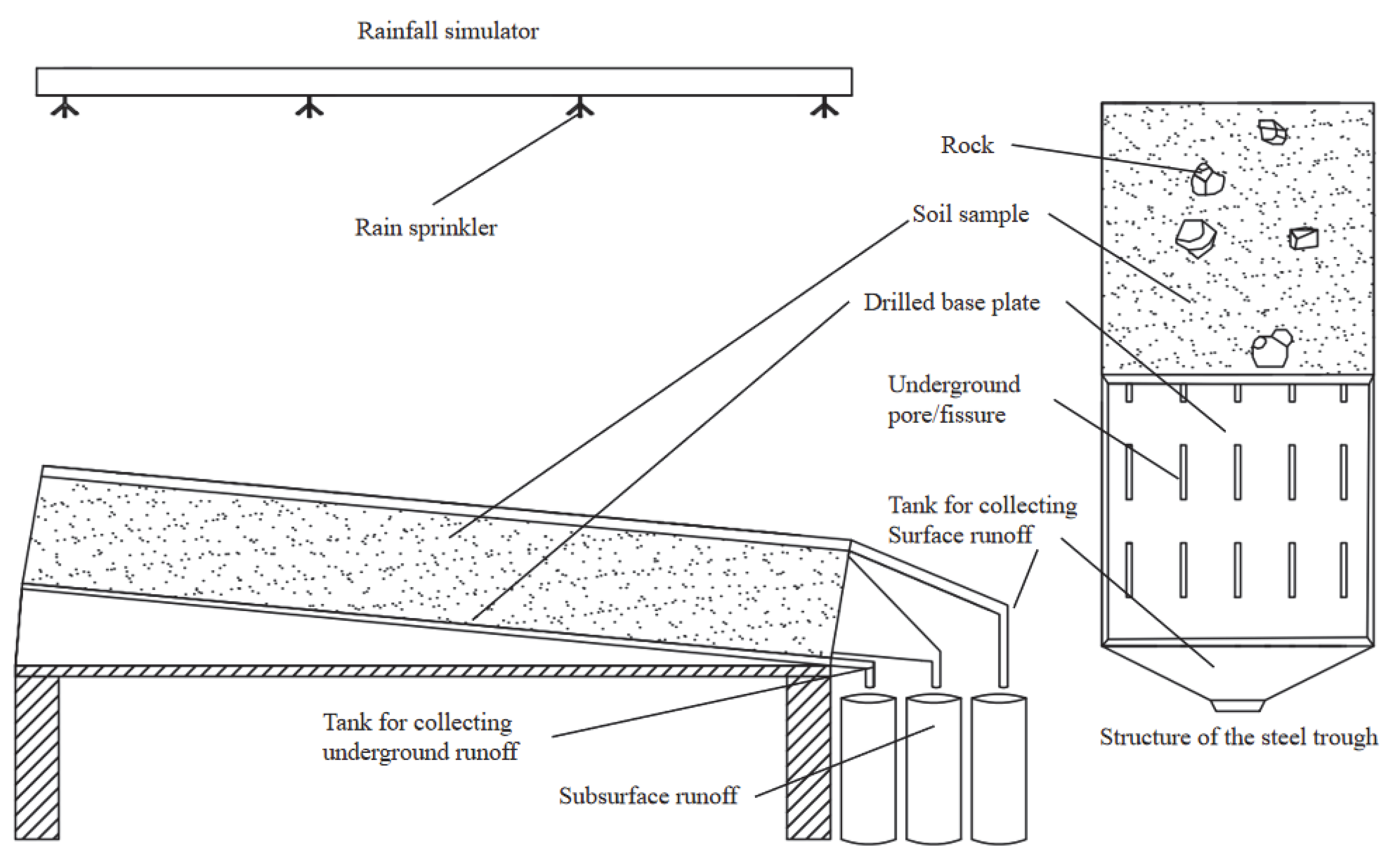
Based on the monitoring data, field survey results, and literature review and analysis of the runoff plots of slope farmland in the study area, we simulated the dual structure of the Karst slope indoors. The experimental apparatus consisted of a variable slope steel trough and an artificial rainfall device (Figure 3). The specifications of the variable slope steel groove were length × width × depth: 2 m × 1 m × 0.35 m, and 25 rectangular holes were drilled evenly at the bottom of the variable slope steel groove (length × width: 2 cm × 10 cm). In this setting, the UPD was 5%, and the slope can be adjusted anywhere from 0 to 25°. Plastic collecting troughs were set up at the surface the subsurface and underground to collect surface runoff, subsurface runoff, and underground runoff, respectively.

2.2.2. Test Soil

We collected soil from sloping farmland in a typical Karst area (106°40′19″ E, 26°21′11″ N) of the Dazhai small watershed, Huaxi District, Guiyang City, Guizhou Province, China. The soil in this area developed from carbonate rocks. The limestone soil developed from carbonate rocks is classified as glossisols in WRB. The soil average bulk density in this area is 135 kg/cm3. The average pH is 7.7; the average organic matter is 9.82 g/kg; the average total nitrogen is 0.55 g/kg; the average total phosphorus is 0.65 g/kg; the moderate total potassium is 25.14 g/kg; the average nitrate-nitrogen is 19.76 mg/kg. The average ammonium nitrogen is 9.70 mg/kg.

2.3. Experimental Design

The rainfall experiment was carried out in the rainfall hall of Guizhou University in Huaxi District, Guiyang City, Guizhou Province. This study considered bedrock exposure rate, UPD, slope, soil characteristics, rainfall intensity, and duration. First, the cracks in the underground pores of the steel tank were adjusted to make the pore area reach 5% of the pre-test design. To simulate the natural Karst slope investigated in the field more realistically, we randomly distributed three limestone blocks with a diameter of 50 cm along the steel trough, with an exposed diameter of 10.3 cm. We took pictures using a digital camera (Sony ZV-1, Tokyo, Japan), calculated limestone using ArcGIS 10.2 (Esri, Redlands, CA, USA), and adjusted bedrock exposure to 10%. According to the soil compaction data measured on-site, three layers of a 10 cm soil layer were filled in the steel tank, and the compaction degree of each layer was 1103 kPa, 410 kPa and 275 kPa from bottom to top. We used fingers to compress the sealed edges to reduce the effect of the boundary. Two slope angles were designed, 5° and 10°, respectively. The underground hole (fissure) gap was 5%; two rainfall intensities were designed: surface erosive rainfall intensity (60 mm/h) and extreme erosive rainfall intensity (90 mm/h). Each experiment was repeated three times.
First, the soil was saturated with light rain (30 mm/h) settling, and then the rainfall test was started with predetermined rainfall intensity. When the surface or underground runoff occurred for the first time, timing started, and runoff and sediment were collected at different periods. According to the statistics of rainfall duration in Huaxi District of Guizhou Province from January 2021 to December 2021, in most cases, the course of rainfall duration was uncertain. Sometimes, there was instantaneous extreme heavy rainfall, especially extreme rainfall duration can reach 1–3 h and sometimes last a day. We conducted a pre-experiment on each rainfall duration set by previous studies for 90 min and found that the runoff yield would begin to flatten when the rainfall reached 30–40 min. Therefore, we set the duration of each rainfall event to 60 min, with samples collected every 5 min and every 10 min after 30 min, measuring runoff with a measuring cylinder. Then, 500 mL of runoff was transferred to the laboratory with polyethylene bottles to determine the concentrations of total nitrogen, nitrate-nitrogen, and ammonium nitrogen in the runoff. We moved runoff and sediment to a 105 °C oven to dry the water and measure sediment mass. After each rainfall, we replaced all soil and refilled the steel trough. Then, we started the next rainfall test.

2.4. Measuring Nutrient Composition

To calculate physical and chemical indexes of water samples, total nitrogen (TN) in water was determined by potassium persulfate oxidation ultraviolet spectrophotometry, nitrate-nitrogen was determined by phenol sulfonic acid spectrophotometry (NO3), ammonium nitrogen was determined by Nessler’s reagent spectrophotometry (NH4+), total phosphorus (TP) was determined by potassium persulfate oxidation-molybdenum antimony resistance colorimetry, and total potassium (TK) was determined by atomic absorption spectrometry. The test method steps mainly refer to the “Water and Wastewater Monitoring and Analysis Method” published by the Chinese Academy of Sciences (Beijing, China). The main instruments were automatic analyzers and TOC analysis instruments provided by the Forestry College of Guizhou University (Guizhou, China).

2.5. Test Method and Data Analysis

We used Excel 2003 (Microsoft, Redmond, WA, USA) and SPSS 20.0 statistical software (IBM, Armonk, NY, USA) for statistical analysis. One-way analysis of variance (ANOVA), multivariate analysis of variance, and standardized regression coefficient β were used to analyze the differences between treatments. The results were plotted using Origin 2021 (OriginLab, Northampton, MA, USA).
(1)
Flow measurement (R)
Before the beginning of the experiment, a plastic bucket was placed at the outlets of surface runoff, soil middle flow, and underground runoff. After the experiment started, the surface, soil middle flow, and underground runoff for each period were measured every 5 min in the first 30 min. After 30 min, the surface, soil middle flow, and underground runoff of each period were measured every 10 min.
(2)
Sediment measurement (M)
The amount of sediment on the surface and underground was measured by different methods according to the situation. When the amount of deposit was small, we removed the supernatant with a quantitative filter paper, filtered the sediment, and transferred it to a beaker. Then, the beaker was placed in an oven, and the residue was dried to a constant weight at 105 °C and weighed. For high sediment content, we removed the supernatant after the standing water samples. The residue was then transferred to a large aluminum box to dry until it reached constant weight. The interflow was a state of flow in the soil and was also in a tiny part of the sediment content in the pre-experimental stage, so sediment outflow was not considered.
(3)
Total nitrogen loss (QTN)
QTN = RW × CTN
where RW is runoff, and CTN is total nitrogen concentration;
(4)
ammonium nitrogen loss ( Q N H 4 + )
Q N H 4 + = R W   ×   ( C N H 4 + )
where C N H 4 + is ammonium nitrogen concentration;
(5)
nitrate-nitrogen loss ( Q N O 3 + ).
Q N O 3 + = R W   ×   C N O 3 +
where C N O 3 + is nitrate-nitrogen concentration.

3. Results Analysis

3.1. Effect of Extreme Rainfall on Runoff Change of Cultivated Land in Karst Gentle Slope

The runoff of Karst bare slope farmland under erosive rainfall includes surface runoff and underground runoff. Its runoff form also determines the way of nitrogen loss in slope soil. Therefore, the analysis of runoff and sediment in slope farmland can lay the foundation for the mechanism of nitrogen loss in Karst slope farmland. In this study, under a slope angle of 5° (Table 1), the surface runoff yield under extreme rainfall conditions was 1.52 times that under moderate rainfall intensity, and the underground runoff yield was 1.36 times that under moderate rainfall. At a slope angle of 10°, the surface runoff under extreme rainfall was 1.84 times that under moderate rainfall, and the underground runoff was 1.51 times that under moderate rainfall. It shows that the runoff under extreme rainfall shows an increasing trend compared to that under moderate rain.
Under the same rainfall intensity, the larger the slope angle of Karst slope farmland, the more prone to surface runoff, and the sediment yield of slope farmland with a slope angle of 10° was more significant than that of a slope angle of 5°. For underground sediment yield, the smaller the slope angle was, the more prone to confidential leakage it was; this also shows that the unique dual structure characteristics of Karsts are different from a normal landform.

3.2. Effects of Extreme Rainfall on Nitrogen Loss in Karst Gentle Slope Farmland

3.2.1. Output Characteristics of Soil Runoff to Total Nitrogen in Karst Slope Farmland

As can be seen from Figure 4, we found that when the slope angle was 5° and 10°, the TN concentration in surface runoff showed a fluctuating downward trend with time. At 40 min, there was a gentle downward trend, mainly because runoff can promote the effective dissolution and release of TN. When the TN content in the soil is constant, the larger the runoff, the greater the dilution effect on TN, so its concentration decreases with the increase of rainfall duration.
Among them, when the slope angle was 5°, the TN concentration of underground runoff with moderate rainfall was the highest. The TN concentration of underground runoff with extreme rainfall was the second. Runoff through the surface, subsurface, and underground can fully dissolve the TN in the ground with water loss. Because the water flows through the 30 cm soil layer, the underground runoff can fully dissolve the TN in the soil, so the total nitrogen content carried by the underground runoff is relatively the highest, followed by the subsurface, and the surface runoff is relatively small.
Due to the difference in TN concentration in the runoff, the loss of TN content within 1 h is also different (Table 2). TN loss is affected by concentration and runoff, so the greater the runoff and TN concentration, the greater the TN loss. By sampling and measuring surface runoff, subsurface runoff, and underground runoff within 1 h, it was found that the greater the rainfall intensity, the greater the TN loss in Karst slope farmland. The underground TN loss is the largest, followed by subsurface TN, and the surface is the smallest. In the case of different slope angles, the larger the slope angle, the easier the surface runoff is formed, so the TN loss is more significant.
Through multivariate analysis of variance (Table 3), we found that the TN loss concentration of Karst slope farmland was mainly affected by slope, rainfall intensity, and rainfall duration.

3.2.2. Characteristics of Soil Ammonium Nitrogen Loss in Karst Slope Farmland

As shown in Figure 5, under the condition of extreme rainfall and moderate rainfall, the concentration of soil ammonium nitrogen with runoff loss showed a fluctuating situation in the first 40 min and began to flatten after 40 min. It shows that the concentration of ammonium nitrogen loss under the condition of erosive rainfall is a changing trend. When the slope angle of was 5°, the surface, subsurface, and underground ammonium nitrogen concentrations of extreme rainfall were significantly higher than those of moderate rain, and the concentration of ammonium nitrogen under extreme rainfall and moderate rainfall was: underground > subsurface > surface; when the slope angle was 10°, the concentration of ammonium nitrogen in the underground, subsurface, and surface of moderate rainfall was higher than that in the underground, subsurface, and surface of extreme rainfall, respectively, indicating that rainfall intensity and slope significantly affect the concentration of ammonium nitrogen. The reason may be that the ammonium nitrogen content in the soil is fixed. The more runoff generated by precipitation, the smaller the ammonium nitrogen concentration of runoff.
Under moderate rainfall (Table 4), ammonium nitrogen was mainly lost underground, and the underground loss reached 2.43 and 2.02 times the surface loss in the slope angle of 5° and 10°, respectively. Under extreme rainfall conditions, the amount of ammonium nitrogen lost underground and on the surface is large. Still, it is also dominated by underground loss, while the content of ammonium nitrogen in interflow is relatively small, and the maximum amount of underground loss can reach 249.06 mg. The underground loss of extreme rainfall in the slope angle of 5° and 10° reached 1.68 and 1.73 times the surface loss, respectively.
Table 5 shows that rainfall intensity, slope angle, and duration significantly affected surface, subsurface, and underground ammonium nitrogen concentrations (p < 0.01). The interaction between rainfall intensity, slope angle, and time significantly affected surface, subsurface, and underground ammonium nitrogen concentrations (p < 0.01).

3.2.3. Characteristics of Soil Nitrate Nitrogen Loss in Karst Slope Farmland

Soil nitrate-nitrogen is the primary nitrogen source of crops. Crops cannot use all of the nitrate-nitrogen at one time. Under erosive rainfall, nitrate-nitrogen easily dissolves in water and washes away as runoff, especially during soil erosion in Karst slope farmland. The loss of nitrate-nitrogen caused by slope runoff has a significant impact on the growth patterns of crops. On farmland with a slope angle of 5° (Figure 6), the concentration of nitrate-nitrogen carried by underground runoff under extreme rainfall conditions is the largest. Due to the rapid infiltration of soil, the average concentration of nitrate-nitrogen in underground runoff reached 2.84 mg/L, followed by the nitrate nitrogen concentration in interflow. The concentration of nitrate-nitrogen in underground runoff under moderate rainfall was also relatively low, with an average concentration of 2.02 mg/L. Under this slope condition, the nitrate nitrogen concentration in the soil was underground > subsurface > surface. On farmland with a slope angle of 10°, under extreme rainfall, the concentration of surface nitrate-nitrogen was higher than that of soil and underground nitrate-nitrogen. The relationship between nitrate-nitrogen concentration was: surface > subsurface > underground.
When the slope angle was 5°, the nitrate-nitrogen concentration in runoff increases with the deepening of the soil layer. When the slope angle was 10°, the nitrate-nitrogen concentration in runoff decreased with the addition of soil depth. However, with the increase in rainfall time, all concentrations showed a decreasing trend.
The loss of nitrate-nitrogen carried by runoff in Karst slope farmland was mainly underground when the slope was 5° (Table 6), and the loss was between 47.68–91.29 mg. When the slope angle reached 10°, it was mainly based on the surface loss, and the loss was between 13.93–29.98 mg. The loss of nitrate-nitrogen carried by rainfall under extreme rainfall conditions was larger than that of moderate rainfall.
Rainfall intensity, slope, and rainfall duration significantly affected the surface, subsurface, and underground nitrate concentration (p < 0.01) (Table 7). The interaction between rainfall intensity, slope, and duration significantly affected the surface diameter, underground, and surface nitrate concentration (p < 0.01).

3.3. Comprehensive Analysis of Nitrogen Loss in Karst Slope Farmland under Extreme Rainfall

Table 8 analyzes the relationship between nitrogen loss concentration and rainfall intensity, slope, rainfall duration, and runoff in Karst slope farmland under erosive rainfall. Slope, rainfall intensity, and rainfall duration were significantly correlated with nitrogen concentration (p < 0.05).
Through multiple regression equation analysis (Table 9) of the obtained results, we determined the relationship between rainfall intensity, slope angle, and rainfall duration in the equation by comparing the absolute values of Beta (×1), Beta (×2), and Beta (×3). The main influencing factors of total nitrogen loss carried by surface and subsurface TN in Karst slope farmland were rainfall intensity, slope angle, and rainfall duration under erosive rainfall. The relationship between the influencing factors was slope > rainfall duration > rainfall intensity by comparing the absolute value of the multiple regression coefficients. Under erosive rain, slope and rainfall duration were the main influencing factors of underground total nitrogen loss. In contrast, the correlation between erosive rainfall intensity and underground TN loss was insignificant. The main influencing factors of ammonium nitrogen loss with runoff in the surface and subsurface were rainfall intensity, slope angle, and rainfall duration. The relationship between the influence was slope angle > rainfall duration > rainfall intensity. The main influencing factors of underground ammonium nitrogen loss were rainfall intensity and duration, among which rainfall duration > rainfall intensity; the main factors affecting the loss of nitrate-nitrogen in the surface, subsurface, and underground were rainfall intensity, slope, and rainfall duration. In contrast, the slope angle negatively correlated with the loss of nitrate-nitrogen in the soil. The influence size was slope angle > rainfall duration > rainfall intensity.

4. Discussion

4.1. Effects of Rainfall Intensity and Slope on Runoff and Sediment Yield in Karst Gentle Slope Farmland

Extreme rainfall impacts nitrogen loss in Karst slope farmland [21]. Rainfall and runoff are the driving forces of soil nitrogen loss and are major carriers and solvents of nitrogen output [29]. Rainfall intensity is one of the critical factors affecting the migration of nitrogen in soil with runoff. The soil erosion process caused by rainfall also removes some nitrogen in the soil [21]. In this study, extreme rainfall significantly promoted surface and underground runoff. Compared with moderate rainfall, surface runoff increased by 1.52–1.84 times, and sediment yield increased by 1.07–1.26 times (Table 1). The subsurface increased by 1.12–1.19 times, the underground runoff increased by 1.36–1.51 times, and the underground sediment yield increased by 1.24–1.26 times. This conclusion is similar to the previous findings of Cuomo et al. [30] that extreme rainfall leads to increased underground leakage and subsurface and surface runoff, resulting in soil erosion. Increasing rainfall intensity increases runoff and raindrop splashing force, and soil particles are eroded by runoff [31]. The conclusion is consistent with the research conclusion of Yan et al. [32]. Under extreme rainfall conditions, the surface sediment yield increases rapidly, and the proportion of underground erosion decreases. However, the underground sediment yield is greater than that under light and moderate rainfall conditions. Because the Karst landforms with underground pores (fissures) have underground leakage and are different from non-Karst landforms, the surface runoff and sediment yield in this study differ from the research results of Mohammed et al. [26,27].

4.2. Effects of Rainfall Intensity and Slope on Nitrogen Loss in Karst Gentle Slope Farmland

4.2.1. Influence Factors of Rainfall Intensity and Slope Gradient on Ammonium Nitrogen Loss in Karst Gentle Slope Farmland

Soil nitrogen in Karst slope farmland is carried by runoff into rivers or subterranean systems as total nitrogen, ammonium nitrogen, and nitrate-nitrogen, thereby polluting water sources [29,33,34]. In this study, the concentration of ammonium nitrogen in the surface, soil, and underground of sloping farmland under extreme rainfall conditions was greater than the loss concentration under moderate rainfall; this may be due to the high content of ammonium nitrogen in the soil of Karst slope farmland, resulting in larger runoff [35]. When the slope angle of Karst slope farmland is 5°, the ammonium nitrogen concentration of the surface, subsurface, and underground under extreme rainfall conditions is significantly higher than that under moderate rainfall. The relation between the concentration of ammonium nitrogen carried in the runoff is underground > subsurface > surface. When the slope angle is 10°, the concentration of ammonium nitrogen in the moderate rain underground, on the subsurface, and the surface is higher than that of extreme rainfall underground; this may be because runoff is more likely to be generated in fields with large slope angles [36,37,38].

4.2.2. Effects of Rainfall Intensity and Slope on Nitrate-Nitrogen Loss in Karst Gentle Slope Farmland

In the soil of Karst slope farmland, crops can only directly use inorganic nitrogen [39]. Nitrifying bacteria in the soil can oxidize ammonium nitrogen soil to nitrite nitrogen, nitrate-nitrogen, and other forms of nitrate, which are conducive to absorption crops [40]. Nitrate-nitrogen is the primary nitrogen form that supplements nitrogen in crop growth and is water soluble. Erosive rainfall creates surface and underground runoff of this nitrate-nitrogen, especially in Karst slope farmland. The loss of nitrate-nitrogen significantly impacts crop growth [39,41,42]. In this study, the loss of nitrate-nitrogen was mainly underground when the slope angle was 5°, but when the slope angle was 10°, it was primarily surface loss. Under extreme rainfall conditions, the loss of nitrate-nitrogen in surface soil was 1.95–2.15 times higher than that under moderate rainfall, while the loss of nitrate-nitrogen in subsurface soil was 1.91–2.21 times higher than that under moderate rainfall [43,44].

4.2.3. The Influencing Factors of Rainfall Intensity and Slope on Total Nitrogen Loss in Karst Gentle Slope Farmland

In this study, the TN concentration in runoff was output in the form of fluctuation at the beginning of runoff and began to follow a gentle downward trend after 40 min. The analysis of nitrogen loss under erosive rainfall within one hour showed that the average loss of surface TN under extreme rainfall conditions was 1.87 times that under moderate rainfall, and the average loss of underground TN was 1.39 times that under moderate rainfall. It showed that rainfall intensity significantly affected soil nitrogen loss. The loss of underground TN under extreme and moderate rainfall was 1.89 times and 2.56 times that of surface TN, respectively. It shows that the underground loss was greater than the surface loss, and the pollution to the groundwater source was more serious, especially in the area where the soil layer was shallow, and the underground pore fissure was developed. This conclusion is similar to the low surface flow coefficient in the Karst area of South China, where nitrogen loss mainly moves with the underground flow [45]. This conclusion is similar to the study by Peng et al., 2019. Gao et al. [46] showed that when the rainfall intensity is ≥ 50mm/h, the surface TN loss ratio is more significant, and the surface flow is the primary carrier of TN loss. The difference may be due to the fracture degree of underground pores [21].
Through multiple regression equation analyses, we found that rainfall intensity, slope angle, and duration were the main influencing factors of soil nitrogen loss in Karst slope farmland. The influencing factors of soil TN and nitrate-nitrogen loss were slope > rainfall duration > rainfall intensity, while the influencing factors of ammonium nitrogen loss were rainfall duration > slope > rainfall intensity. It shows that the slope angle of Karst gentle slope farmland has an important influence on the loss of nitrogen, and the failure of nitrogen on the slope angle can be slowed by changing the slope angle to the ladder. However, this study has not considered the effect of Karst underground material on the connectivity of underground fissure systems and the migration of nutrients in fissures. Although the loss of nitrogen underground is relatively significant and the pollution of the groundwater hydrological system is severe, the loss of nitrogen underground is challenging to control and easy to be ignored because of the hidden underground. Therefore, controlling the flow of Karst underground pores (fissures) can directly prevent Karst groundwater pollution, and this control is crucial to avoid further non-point source pollution. In addition, relevant studies have shown that precision fertilization can reduce the waste of agricultural fertilizers [47], or increased vegetation coverage can reduce the loss of nutrients on the slope [48,49]. Therefore, we can consider precision fertilization or increasing slope coverage at the beginning of tillage as a measure to maintain temperature and fertilizer to slow down the impact of rainfall on nitrogen in cultivated soil and underground leakage, thereby increasing production and preventing pollution.

5. Conclusions

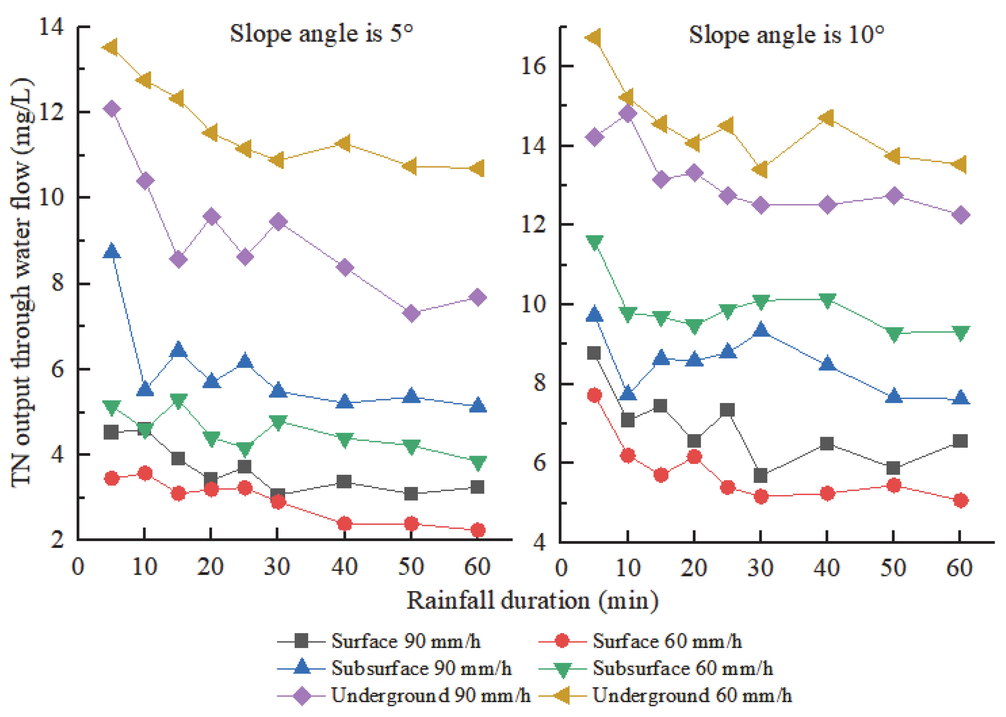
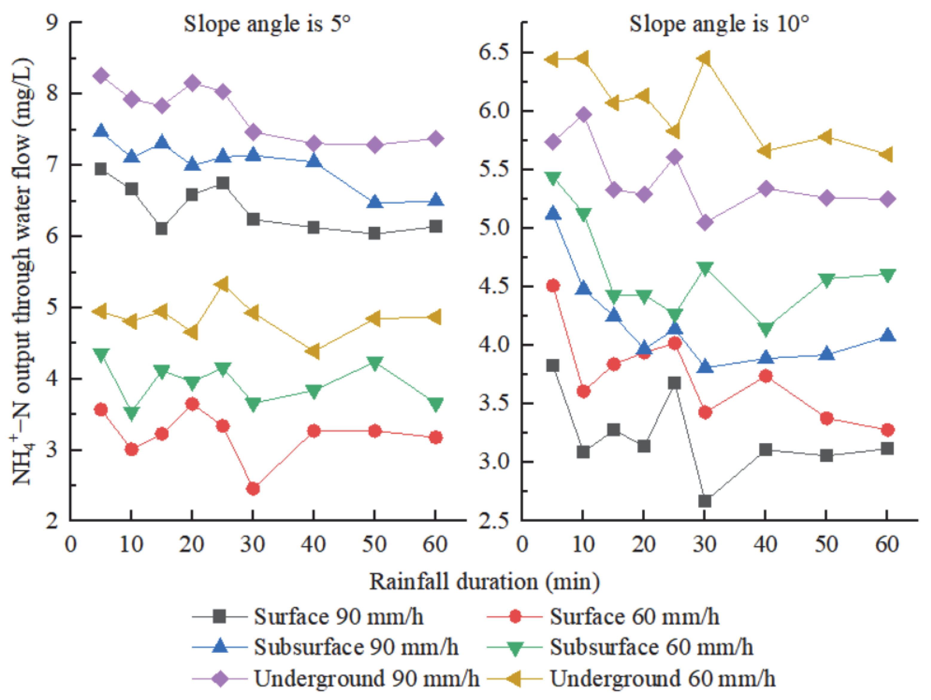
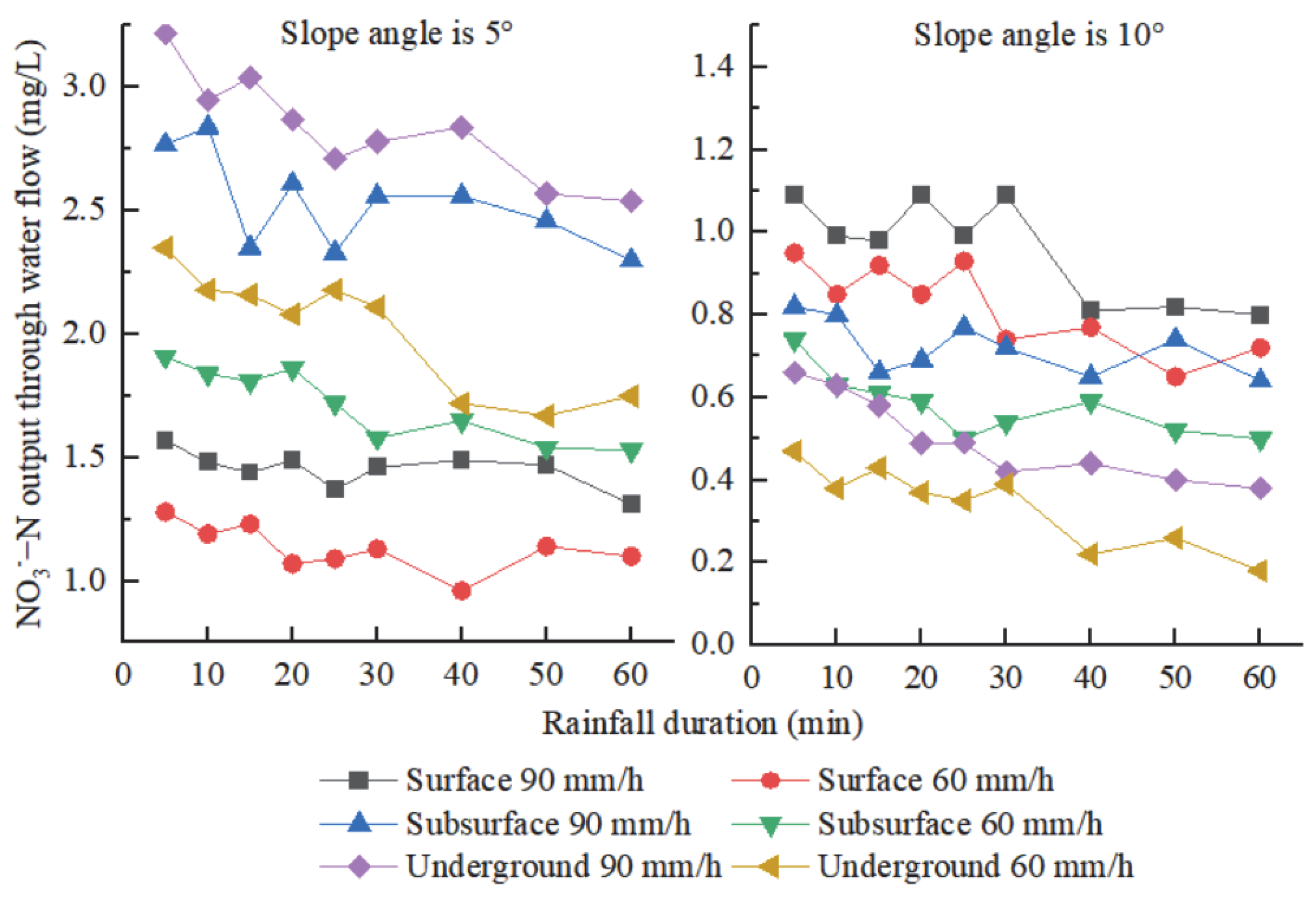
Under the same slope condition of Karst slope farmland, compared with moderate rainfall, extreme rainfall increased surface runoff, subsurface runoff, and underground runoff. The increase in runoff significantly affects the amount of nitrogen loss. The loss of ammonium nitrogen under extreme rainfall conditions is considerably higher than that under moderate rainfall, and the loss of ammonium nitrogen is mainly from underground loss and surface loss. When the slope is 10°, it is primarily underground, and when the slope reaches 10°, it is mainly the loss of surface, and the of nitrate-nitrogen carried by runoff is the largest under extreme rainfall conditions. Compared with moderate rainfall, the total nitrogen loss taken by the runoff also increases; the TN loss carried by the underground runoff was the largest, followed by the subsurface, and the surface was the smallest. The relationship between the influencing factors of surface TN and ammonium nitrogen loss is slope angle> rainfall duration> rainfall intensity. Under erosive rainfall conditions, the main influencing factors of underground TN loss are slope and rainfall duration; underground ammonium nitrogen loss is mainly determined by rainfall intensity and rainfall duration, in which rainfall duration > rainfall intensity. The main determinants of nitrate-nitrogen loss from the surface, the subsurface, and underground of Karst slope farmland are slope angle > rainfall duration > rainfall intensity. So, we suggest that in controlling nitrogen loss, we can reduce the extreme rainfall erosion of the slope angle by changing the slope to a terrace and increasing the surface coverage. The main methods to control pollution of groundwater sources may be precise or efficient fertilization or cement plugging of underground holes (cracks).

Author Contributions

Y.W. and Q.D. contributed to the conception of the study; Y.W., P.D., M.Z. and Y.Y. (Yingchong Yang) performed the experiment; Y.W. and Q.D. contributed significantly to analysis and manuscript preparation; Y.W., K.L., X.Y., J.H. and Y.Y. (Youjin Yan) performed the data analyses and wrote the manuscript; Y.W., X.P. and Q.D. helped perform the analysis with constructive discussions. All authors have read and agreed to the published version of the manuscript.

Funding

This research was funded by China Postdoctoral Science Foundation (2020M673296), Natural Science Foundation of China (42167044, 42007054), the High-level Innovative Talents in Guizhou Province of Guizhou Province (Qian Ke He Platform Talents (2018)5641), the Guizhou Province Graduate Research Fund (YJSCXJH [2020]065, YJSCXJH [2020]066), the first-class discipline Construction Project of Guizhou Province (GNYL (2017)007), Qian Ke He support [2020]1Y011, and the Cultivation project of Guizhou University (Cultivation (2019) No.10 of Guizhou University).

Data Availability Statement

Not applicable.

Acknowledgments

All the authors especially appreciate the experimental equipment provided by the College of Forestry, Guizhou University, and the Institute of Soil Erosion and Ecological Restoration, Guizhou University.

Conflicts of Interest

The authors declare no conflict of interest.

References

  1. Rocci, K.S.; Lavallee, J.M.; Stewart, C.E.; Cotrufo, M.F. Soil organic carbon response to global environmental change depends on its distribution between mineral-associated and particulate organic matter: A meta-analysis. Sci. Total Environ. 2021, 793, 148569. [Google Scholar] [CrossRef] [PubMed]
  2. Bai, Y.; Zhou, Y. The main factors controlling spatial variability of soil organic carbon in a small Karst watershed, Guizhou Province, China. Geoderma 2020, 357, 113938. [Google Scholar] [CrossRef]
  3. Canfield, D.E.; Glazer, A.N.; Falkowski, P.G. The evolution and future of earth’s nitrogen cycle. Science 2010, 330, 192–196. [Google Scholar] [CrossRef] [PubMed] [Green Version]
  4. Xue, Z.; Cheng, M.; An, S. Soil nitrogen distributions for different land uses and landscape positions in a small watershed on Loess Plateau, China. Ecol. Eng. 2013, 60, 204–213. [Google Scholar] [CrossRef]
  5. Sun, B.; Gu, L.; Bao, L.; Zhang, S.; Wei, Y.; Bai, Z.; Zhuang, G.; Zhuang, X. Application of biofertilizer containing Bacillus subtilis reduced the nitrogen loss in agricultural soil. Soil Biol. Biochem. 2020, 148, 107911. [Google Scholar] [CrossRef]
  6. Dash, S.; Borah, S.S.; Kalamdhad, A.S. Study of the limnology of wetlands through a one-dimensional model for assessing the eutrophication levels induced by various pollution sources. Ecol. Model. 2020, 416, 108907. [Google Scholar] [CrossRef]
  7. Nunes, V.L.N.; Mulvaney, R.L. Controlling organic interference in determination of soil mineral nitrogen. Soil Sci. Soc. Am. J. 2021, 85, 919–928. [Google Scholar] [CrossRef]
  8. Wang, Z.; Miao, Y.; Li, S. Effect of ammonium and nitrate nitrogen fertilizers on wheat yield in relation to accumulated nitrate at different depths of soil in drylands of China. Field Crop. Res. 2015, 183, 211–224. [Google Scholar] [CrossRef]
  9. Liao, K.; Lv, L.; Lai, X.; Zhu, Q. Toward a framework for the multimodel ensemble prediction of soil nitrogen losses. Ecol. Model. 2021, 456, 109675. [Google Scholar] [CrossRef]
  10. Ludeña, C.; de Miguel, C.; Schuschny, A. Climate change and Carbon markets: Implications for developing countries. CEPAL Rev. 2016, 2015, 61–84. [Google Scholar] [CrossRef]
  11. Zhou, F.; Zhang, W.; Su, W.; Peng, H.; Zhou, S. Spatial differentiation and driving mechanism of rural water security in typical “engineering water depletion” of Karst mountainous area—A lesson of Guizhou, China. Sci. Total Environ. 2021, 793, 148387. [Google Scholar] [CrossRef] [PubMed]
  12. Xiao, P.; Xiao, B.; Adnan, M. Effects of Ca2+ on migration of dissolved organic matter in limestone soils of the southwest China Karst area. Land Degrad. Dev. 2021, 32, 5069–5082. [Google Scholar] [CrossRef]
  13. Li, S.; Ren, H.D.; Xue, L.; Chang, J.; Yao, X.H. Influence of bare rocks on surrounding soil moisture in the Karst rocky desertification regions under drought conditions. Catena 2014, 116, 157–162. [Google Scholar] [CrossRef]
  14. Wang, J.; Zou, B.; Liu, Y.; Tang, Y.; Zhang, X.; Yang, P. Erosion-creep-collapse mechanism of underground soil loss for the Karst rocky desertification in Chenqi village, Puding county, Guizhou, China. Environ Earth Sci. 2014, 72, 2751–2764. [Google Scholar] [CrossRef]
  15. Li, J.; Pu, J.; Zhang, T.; Xiong, X.; Wang, S.; Huo, W.; Yuan, D. Measurable sediment discharge from a Karst underground river in southwestern China: Temporal variabilities and controlling factors. Environ. Earth Sci. 2020, 79, 90. [Google Scholar] [CrossRef]
  16. Dai, Q.; Peng, X.; Zhao, L.; Shao, H.; Yang, Z. Effects of Underground Pore Fissures on Soil Erosion and Sediment Yield on Karst Slopes. Land Degrad. Dev. 2017, 28, 1922–1932. [Google Scholar] [CrossRef]
  17. Zhu, X.F.; Chen, H.S.; Fu, Z.Y.; Wang, K.L.; Zhang, W.; Xu, Q.X.; Fang, R.J. Runoff and nitrogen loss characteristics in soil-epiKarst system on a Karst shrub hillslope. Chin. J. Appl. Ecol. 2017, 28, 2197–2206. [Google Scholar] [CrossRef]
  18. Zhu, Z.; Wang, J.; Hu, M.; Jia, L. Geographical detection of groundwater pollution vulnerability and hazard in Karst areas of Guangxi Province, China. Environ. Pollut. 2019, 245, 627–633. [Google Scholar] [CrossRef] [PubMed]
  19. Guo, Z.; Zhang, X.; Dungait, J.A.J.; Green, S.M.; Quine, T.A. Contribution of soil microbial necromass to SOC stocks during vegetation recovery in a subtropical Karst ecosystem. Sci. Total Environ. 2021, 761, 143945. [Google Scholar] [CrossRef] [PubMed]
  20. Huo, J.; Yu, X.; Liu, C.; Chen, L.; Zheng, W.; Yang, Y.; Tang, Z. Effects of soil and water conservation management and rainfall types on runoff and soil loss for a sloping area in North China. Land Degrad. Dev. 2020, 31, 2117–2130. [Google Scholar] [CrossRef]
  21. Wang, Z.-J.; Yue, F.-J.; Wang, Y.-C.; Qin, C.-Q.; Ding, H.; Xue, L.-L.; Li, S.-L. The effect of heavy rainfall events on nitrogen patterns in agricultural surface and underground streams and the implications for Karst water quality protection. Agric. Water Manag. 2022, 266, 107600. [Google Scholar] [CrossRef]
  22. Fu, Z.Y.; Chen, H.S.; Zhang, W.; Xu, Q.X.; Wang, S.; Wang, K.L. Subsurface flow in a soil-mantled subtropical dolomite Karst slope: A field rainfall simulation study. Geomorphology 2015, 250, 1–14. [Google Scholar] [CrossRef]
  23. Fu, Z.; Chen, H.; Xu, Q.; Jia, J.; Wang, S.; Wang, K. Role of epiKarst in near-surface hydrological processes in a soil mantled subtropical dolomite Karst slope: Implications of field rainfall simulation experiments. Hydrol. Process. 2016, 30, 795–811. [Google Scholar] [CrossRef]
  24. Bai, X.; Zhang, X.; Long, Y.; Liu, X.; Siyu, Z. Use of 137Cs and 210Pbex measurements on deposits in a Karst depression to study the erosional response of a small Karst catchment in Southwest China to land-use change. Hydrol. Process. 2013, 27, 822–829. [Google Scholar] [CrossRef]
  25. Zheng, H.; Nie, X.; Liu, Z.; Mo, M.; Song, Y. Identifying optimal ridge practices under different rainfall types on runoff and soil loss from sloping farmland in a humid subtropical region of Southern China. Agric. Water Manag. 2021, 255, 107043. [Google Scholar] [CrossRef]
  26. Mohammed, S.; Hassan, E.; Abdo, H.G.; Szabo, S.; Mokhtar, A.; Alsafadi, K.; Al-Khouri, I.; Rodrigo-Comino, J. Impacts of rainstorms on soil erosion and organic matter for different cover crop systems in the western coast agricultural region of Syria. Soil Use Manag. 2021, 37, 196–213. [Google Scholar] [CrossRef]
  27. Mohammed, S.; Abdo, H.G.; Szabo, S.; Pham, Q.B.; Holb, I.J.; Linh, N.T.T.; Anh, D.T.; Alsafadi, K.; Mokhtar, A.; Kbibo, I.; et al. Estimating human impacts on soil erosion considering different hillslope inclinations and land uses in the coastal region of syria. Water 2020, 12, 2786. [Google Scholar] [CrossRef]
  28. Peng, X.; Dai, Q.; Li, C.; Zhao, L. Role of underground fissure flow in near-surface rainfall-runoff process on a rock mantled slope in the Karst rocky desertification area. Eng. Geol. 2018, 243, 10–17. [Google Scholar] [CrossRef]
  29. Peng, X.; Dai, Q.; Ding, G.; Li, C. Role of underground leakage in soil, water and nutrient loss from a rock-mantled slope in the Karst rocky desertification area. J. Hydrol. 2019, 578, 124086. [Google Scholar] [CrossRef]
  30. Cuomo, S.; Della Sala, M.; Novità, A. Physically based modelling of soil erosion induced by rainfall in small mountain basins. Geomorphology 2015, 243, 106–115. [Google Scholar] [CrossRef]
  31. Vaezi, A.R.; Ahmadi, M.; Cerdà, A. Contribution of raindrop impact to the change of soil physical properties and water erosion under semi-arid rainfalls. Sci. Total Environ. 2017, 583, 382–392. [Google Scholar] [CrossRef] [PubMed]
  32. Yan, Y.; Dai, Q.; Yuan, Y.; Peng, X.; Zhao, L.; Yang, J. Effects of rainfall intensity on runoff and sediment yields on bare slopes in a Karst area, SW China. Geoderma 2018, 330, 30–40. [Google Scholar] [CrossRef]
  33. Gentry, L.E.; David, M.B.; Smith, K.M.; Kovacic, D.A. Nitrogen cycling and tile drainage nitrate loss in a corn/soybean watershed. Agric. Ecosyst. Environ. 1998, 68, 85–97. [Google Scholar] [CrossRef]
  34. Zhang, Y.; Wu, H.; Yao, M.; Zhou, J.; Wu, K.; Hu, M.; Shen, H.; Chen, D. Estimation of nitrogen runoff loss from croplands in the Yangtze River Basin: A meta-analysis. Environ. Pollut. 2021, 272, 116001. [Google Scholar] [CrossRef]
  35. Zhang, S.; Chen, S.; Fenton, O.; Li, Y.; Chen, Q. Enhanced topsoil P leaching in a short term flooded calcareous soil with combined straw and ammonium nitrogen incorporation. Geoderma 2021, 402, 115322. [Google Scholar] [CrossRef]
  36. Ziadat, F.M.; Taimeh, A.Y. Effect of rainfall intensity, slope, land use and antecedent soil moisture on soil erosion in an arid environment. Land Degrad. Dev. 2013, 24, 582–590. [Google Scholar] [CrossRef]
  37. Shen, H.; Zheng, F.; Wen, L.; Han, Y.; Hu, W. Impacts of rainfall intensity and slope gradient on rill erosion processes at loessial hillslope. Soil Tillage Res. 2016, 155, 429–436. [Google Scholar] [CrossRef]
  38. Wu, L.; Peng, M.; Qiao, S.; Ma, X. Assessing impacts of rainfall intensity and slope on dissolved and adsorbed nitrogen loss under bare loessial soil by simulated rainfalls. Catena 2018, 170, 51–63. [Google Scholar] [CrossRef]
  39. Schröder, J.J.; Neeteson, J.J.; Oenema, O.; Struik, P.C. Does the crop or the soil indicate how to save nitrogen in maize production? Reviewing the state of the art. Field Crop. Res. 2000, 66, 151–164. [Google Scholar] [CrossRef]
  40. Kim, W.K.; Patterson, P.H. Ammonium-nitrogen transformation and nitrogen retention in broiler manure supplemented with a soil amendment containing nitrifying bacteria. J. Environ. Sci. Health Part B 2006, 41, 121–133. [Google Scholar] [CrossRef] [PubMed]
  41. Wang, H.J.; Wu, L.H.; Tao, Q.N.; Miller, D.D.; Welch, R.M. Glutamine nitrogen and ammonium nitrogen supplied as a nitrogen source is not converted into nitrate nitrogen of plant tissues of hydroponically Grown Pak-Choi (Brassica chinensis L.). J. Food Sci. 2009, 74, T21–T23. [Google Scholar] [CrossRef] [PubMed]
  42. Pareek, S.; Kumari, K.; Awan, T.; Sharma, A.; Shrivastava, D. Guar (Cyamopsis tetragonoloba [L.] Taub.) response to organic and inorganic nitrogen sources during early seedling growth. J. Plant Nutr. 2022, 45, 2135–2145. [Google Scholar] [CrossRef]
  43. Wang, Y.; Ying, H.; Yin, Y.; Zheng, H.; Cui, Z. Estimating soil nitrate leaching of nitrogen fertilizer from global meta-analysis. Sci. Total Environ. 2018, 657, 96–1029. [Google Scholar] [CrossRef] [PubMed]
  44. Stanley, C.D.; Green, R.E.; Khan, M.A.; Santo, L.T. Nitrogen-Fertilization Rate and Soil Nitrate Distribution for Microirrigated Sugarcane. Soil Sci. Soc. Am. J. 1990, 54, 217–222. [Google Scholar] [CrossRef]
  45. Song, X.; Gao, Y.; Green, S.M.; Dungait, J.A.J.; Peng, T.; Quine, T.A.; Xiong, B.; Wen, X.; He, N. Nitrogen loss from Karst area in China in recent 50 years: An in-situ simulated rainfall experiment’s assessment. Ecol. Evol. 2017, 7, 10131–10142. [Google Scholar] [CrossRef] [PubMed]
  46. Gao, R.; Dai, Q.; Gan, Y.; Peng, X.; Yan, Y. The production processes and characteristics of nitrogen pollution in bare sloping farmland in a Karst region. Environ. Sci. Pollut. Res. 2019, 26, 26900–26911. [Google Scholar] [CrossRef]
  47. Fan, J.; Lu, X.; Gu, S.; Guo, X. Improving nutrient and water use efficiencies using water-drip irrigation and fertilization technology in Northeast China. Agric. Water Manag. 2020, 241, 106352. [Google Scholar] [CrossRef]
  48. Gao, Y.; Zhu, B.; Wang, T.; Tang, J.L.; Zhou, P.; Miao, C.Y. Bioavailable phosphorus transport from a hillslope cropland of purple soil under natural and simulated rainfall. Environ. Monit. Assess. 2010, 171, 539–550. [Google Scholar] [CrossRef] [PubMed]
  49. Gao, Y.; Zhu, B.; Zhou, P.; Tang, J.L.; Wang, T.; Miao, C.Y. Effects of vegetation cover on phosphorus loss from a hillslope cropland of purple soil under simulated rainfall: A case study in China. Nutr. Cycl. Agroecosyst. 2009, 85, 263–273. [Google Scholar] [CrossRef]
Figure 1. Geographical location and partial overview of the runoff community.
Water 14 03341 g001
Figure 2. Daily rainfall data of sample plots during 2021.
Water 14 03341 g002
Figure 3. Simulated rainfall device and steel trough device diagram.
Water 14 03341 g003
Figure 4. Variation of TN concentration in Karst slope farmland with time.
Water 14 03341 g004
Figure 5. Variation of ammonium nitrogen output concentration through water flow in Karst slope farmland with time.
Water 14 03341 g005
Figure 6. Variation of nitrate-nitrogen output concentration through water flow in Karst slope farmland with time.
Water 14 03341 g006
Table 1. Characteristics of soil runoff and sediment yield in Karst slope farmland.
IndexSoil LayerModerate Rain (60 mm/h)Extreme Rainfall (90 mm/h)
Slope Angle (5°)Slope Angle (10°)Slope Angle (5°)Slope Angle (10°)
Runoff (L)Surface15.24 ± 0.07 b16.96 ± 0.10 a23.1 ± 0.01 b31.15 ± 0.25 a
Subsurface10.29 ± 0.33 b10.94 ± 0.30 a11.49 ± 0.06 b13.04 ± 0.06 a
Underground23.59 ± 0.22 b21.25 ± 0.43 a32.17 ± 1.8 a32.07 ± 2.04 a
Sediment (g)Surface35.19 ± 2.99 b46.28 ± 3.37 a44.32 ± 1.8 b49.72 ± 2.47 a
Subsurface0000
Underground13.96 ± 1.37 b12.34 ± 0.16 b17.66 ± 0.59 a15.24 ± 1.45 b
Note: The data in the table are mean and standard deviation; different lowercase letters in the same line indicate significant differences in LSD tests based on runoff results under the same rainfall intensity and different slope gradients (<0.05).
Table 2. TN loss per hour per square meter of sloping farmland.
IndexSoil LayerModerate Rain (60 mm/h)Extreme Rainfall (90 mm/h)
Slope Angle (5°)Slope Angle (10°)Slope Angle (5°)Slope Angle (10°)
Q T N (mg)Surface121.18 ± 0.79 b183.08 ± 1.67 a200.17 ± 2.72 b369.81 ± 5.80 a
Subsurface98.28 ± 2.84 b163.40 ± 3.36 a126.05 ± 1.18 b176.06 ± 0.87 a
Underground392.94 ± 4.56 a385.64 ± 7.63 b454.54 ± 26.74 b625.18 ± 37.28 a
Note: The data in the table are mean and standard deviation; lowercase letters indicate significant differences in total nitrogen loss between different slopes at the same rainfall intensity (p < 0.05).
Table 3. Multivariate analysis of variance of TN concentration and influencing factors.
Factors Surface   C T N Subsurface   C T N Underground   C T N
FpFpFp
Slope angle3819.21<0.016306.63<0.016540.08<0.01
Rainfall intensity334.95<0.01NA>0.052092.77<0.01
Rainfall duration76.21<0.0182.42<0.01252.95<0.01
Slope angle × Rainfall intensity13.76<0.01818.97<0.01193.83<0.01
Slope angle × Rainfall duration12.22<0.017.54<0.0115.28<0.01
Rainfall intensity × Rainfall duration6.98<0.018.94<0.0116.87<0.01
Slope angle × Rainfall intensity × Rainfall duration3.49 <0.0113.71 <0.0118.73 <0.01
Table 4. Output of ammonium nitrogen per hour on sloping farmland per square meter.
IndexSoil LayerModerate Rain (60 mm/h)Extreme Rainfall (90 mm/h)
Slope Angle (5°)Slope Angle (10°)Slope Angle (5°)Slope Angle (10°)
Q N H 4 + (mg)Surface47.20 ± 0.16 b63.61 ± 0.35 a147.88 ± 0.55 a100.33 ± 0.46 b
Subsurface40.63 ± 1.22 b50.73 ± 1.76 a80.59 ± 0.71 a54.56 ± 0.53 b
Underground114.64 ± 2.69 b128.51 ± 14.74 a249.06 ± 14.46 a174.07 ± 2.30 b
Note: Lowercase letters indicate significant differences between different slopes with the same rainfall intensity (p < 0.05).
Table 5. Multivariate analysis of variance of runoff ammonium nitrogen concentration with rainfall intensity, slope, and rainfall duration in Karst slope farmland.
Factors Surface   C N H 4 + Subsurface   C N H 4 + Underground   C N H 4 +
FpFpFp
Slope angle2986.32<0.011924.69<0.01267.71<0.01
Rainfall intensity3597.58<0.012870.64<0.011080.38<0.01
Rainfall duration67.93<0.0155.05<0.0120.78<0.01
Slope angle × Rainfall intensity6869.04<0.015174.29<0.012591.37<0.01
Slope angle × Rainfall duration10.2<0.0123.44<0.015.11<0.01
Rainfall intensity × Rainfall duration14.63<0.019.28<0.015.89<0.01
Slope angle × Rainfall intensity × Rainfall duration21.33<0.0110.49<0.016.54<0.01
Table 6. Nitrate-nitrogen loss per hour per square meter of sloping farmland.
IndexSoil LayerModerate Rain (60 mm/h)Extreme Rainfall (90 mm/h)
Slope Angle (5°)Slope Angle (10°)Slope Angle (5°)Slope Angle (10°)
Q N O 3 (mg)Surface17.26 ± 0.10 a13.93 ± 0.79 b33.58 ± 0.17 a29.98 ± 0.47 b
Subsurface17.66 ± 0.32 a6.35 ± 0.08 b29.08 ± 0.52 a9.38 ± 0.84 b
Underground47.68 ± 1.28 a7.22 ± 2.02 b91.29 ± 5.82 a15.98 ± 0.36 b
Note: Lowercase letters indicate significant differences between different slopes with the same rainfall intensity (p < 0.05).
Table 7. Multivariate analysis of variance of nitrate-nitrogen concentration in runoff of Karst slope farmland with rainfall intensity, slope, and rainfall duration.
Factors Surface   C N O 3 + Subsurface   C N O 3 + Underground   C N O 3 +
FpFpFp
Slope angle412.45<0.012812.45<0.0110737.33<0.01
Rainfall intensity136.86<0.01294.54<0.01628.63<0.01
Rainfall duration6.61<0.016.02<0.0128.17<0.01
Slope angle × Rainfall intensity20.52<0.01147.68<0.01286.35<0.01
Slope angle × Rainfall duration2.14<0.05NA>0.054.79<0.01
Rainfall intensity × Rainfall durationNA>0.05NA>0.053.03<0.01
Table 8. Correlation analysis of slope and rainfall intensity with soil nitrogen loss concentration.
FactorsRainfall DurationSlope AngleRainfall IntensitySurface RunoffSubsurface RunoffUnderground Runoff
Surface C T N −0.30 **0.87 **0.26 **−0.06−0.20 *−0.17
Subsurface C T N −0.20 *0.88 **0.00−0.08−0.14−0.15
Underground C T N −0.36 **0.76 **−0.43 **−0.033 **−0.34 **−0.029 **
Surface C N H 4 + −0.10 *−0.46 **0.50 **−0.06−0.09−0.14
Subsurface C N H 4 + −0.15 *−0.42 **0.52 **−0.11−0.15−0.19
Underground C N H 4 + −0.17 *−0.25 **0.50 **−0.11−0.16−0.22 *
Surface C N O 3 −0.25 **−0.75 **0.43 **−0.22 *−0.27 **−0.03 **
Subsurface C N O 3 −0.10 *−0.91 **0.29 **−0.13−0.13−0.13
Underground C N O 3 −0.13 *−0.95 **0.23 *−0.19−0.17−0.18
Note: “ * ” indicated that there was a significant correlation between each influencing factor and the concentration of various forms of nitrogen (p < 0.05), and “ ** ” indicated that there was a significant correlation between each influencing factor and the concentration of various forms of nitrogen (p < 0.001).
Table 9. Factors affect nitrogen loss of rainfall intensity (×1), slope angle (×2), and rainfall duration (×3).
IndexesRegression EquationR2Standardized Coefficients
Beta (×1)Beta (×2)Beta (×3)
Surface Q T N y = 0.480 × 1 + 2.490 × 2+ 0.887 × 3 − 56.3760.8260.3590.3110.775
Subsurface Q T N y = 0.068 × 1 + 1.301 × 2 + 0.589 × 3 − 16.2650.8630.0870.2790.882
Underground Q T N y = 3.070 × 2 + 2.044 × 3 − 34.7630.807Sig > 0.050.1890.878
Surface Q N H 4 + y = 0.246 × 1 − 0.384 × 2 + 0.368 × 3 − 16.2430.8140.4440.1160.776
Subsurface Q N H 4 + y = 0.077 × 1 − 0.197 × 2 + 0.237 × 3 − 4.8910.8310.243−0.1040.872
Underground Q N H 4 + y = 0.204 × 1 + 0.715 × 3 − 19.3450.8770.223Sig > 0.050.909
Surface Q N O 3 y = 0.058 × 1 − 1.000 × 2 + 0.092 × 3 − 3.7040.8290.432−0.1230.792
Subsurface Q N O 3 y = 0.027 × 1 − 0.333 × 2 + 0.063 × 3 + 0.3510.7410.243−0.4980.658
Underground Q N O 3 y = 0.053 × 1 − 0.981 × 2 + 0.137 × 3 + 3.0430.7390.193−0.5990.586
Publisher’s Note: MDPI stays neutral with regard to jurisdictional claims in published maps and institutional affiliations.

