1. Introduction
Currently, the discussion about the role of methane as the most sensitive indicator of the evolutionary climate change processes remains one of the most discussed topics in ocean sciences [
1,
2,
3,
4]. Information about the amount of methane flow into the atmosphere is extremely contradictory. Models from insignificant emissions to explosive emissions leading to a global catastrophe are considered. Data concerning dynamics of the methane flow are limited, and little is known about the factors controlling it [
5]. The contribution of the oceans to global methane emissions into the atmosphere remains very uncertain. Various studies have recognized that open oceans are a source of methane into the atmosphere contributing from 0.005% to 3% of global methane production [
6], although the main mechanism of methane production remains unclear. According to some estimates, the flow of methane from the World Ocean into the atmosphere is 6 million tons of CH
4 per year on the ocean area (3.6 × 10¹⁴ m
2) with an average flow of methane into the atmosphere of 2.5 mol/(km
2 × day) [
7].
As climate and chemical composition of the atmosphere transform, the World Ocean also meets global changes. An increase in the concentration of carbon dioxide in the atmosphere directly leads to ocean acidification [
8,
9]. Another global process is ocean deoxygenation [
10]. Recent biogeochemical studies have shown that all of the above processes directly affect the carbonate system and the hydrochemical characteristics of the waters of the Southern Ocean [
11,
12,
13,
14]. In this regard, the Southern Ocean has its own characteristics. The most important hydrological feature is the Antarctic circumpolar current and the large depth of the upper mixed water layer exceeding 400 m [
15,
16]. Due to intensive vertical circulation, methane is involved in the deep layers of the ocean [
13].
Bottom waters in the deep-sea channels of the Atlantic spread from their sources on the shelf of Antarctica, flowing from one basin to another. The process of such overflow often concentrates channels, faults and passages connecting the abyssal of individual basins. At the same time, due to intensive interaction with the bottom in the channels, a significant transformation of the thermohaline properties of bottom waters occurs. These circumstances make expedition research in the Southern Ocean especially important from the point of view of studying the large-scale meridional circulation of the World Ocean.
In addition, the analysis of available geological and geophysical materials revealed that in the research area there are active permeability zones (fault zones, crushing zones, rifts, etc.) for gases and fluids of both a deep nature associated with rifting, and prospects for detecting near-surface active seeps of reduced gases, in particular methane. There are certain prerequisites for gas hydrates detection, so it is possible to predict the presence of gas “torches”—jet outflows of gas bubbles from the seabed into the water column. In other areas of the World Ocean, it has been established that such sites are often hotbeds of active development of biological communities involved in the food chain of underwater biocenoses. There is practically no specific information about gas or gas-fluid manifestations in the research area. Almost all Antarctic coastal waters are large sedimentary basins of a significant hydrocarbon deposits potential. The largest of them are the basins of the Weddell Seas (1.5 million square kilometers), Ross (1.26 million square kilometers), Mawson (710 thousand square kilometers), Commonwealth (580 thousand square kilometers) and Riser-Larsen (400 thousand square kilometers). According to modern data based on complex geophysical studies, the projected hydrocarbon resources in all marine sedimentary basins of Antarctica could reach (taking into account deep-water areas) some tens of billions of tons.
In general, in the research region there are geological objects that have a strong influence on the hydrodynamic and hydrological regime of the water area (ridges, depressions, rifts, etc.). Detailed geophysical and geological studies of these structures have not yet been completed, so the bottom relief and the structure of orographic barriers are relevant issues for the study of the hydrodynamic regime of the research area in the future. Our paper presents the results of detailed gas-geochemical studies of methane distribution in the water column of the Bransfield Strait, Antarctica Strait and the Weddell Sea in cruise 87 of the R/V “Academik Mstislav Keldysh”, 7 December 2021–5 April 2022. Data obtained allowed us to assess the influence of currents on the distribution of methane fields in the water column and outline prospects for further research.
2. Materials and Methods
Gas-geochemical research makes it possible to assess the variability of the methane content and a number of its homologues (ethane, propane, butane) in seawater along the horizons, to identify the sources of gas flow, as well as to obtain information for further assessment of the relationship of background and anomalous gas-geochemical fields with morphostructural and tectonic elements of the geological structure.
Sampling and analysis in the studied areas of the Southern Ocean (the Bransfield Strait, Antarctica Strait and the Weddell Sea) in cruise 87 was carried out in the period 19 January–3 February 2022.
Water sampling from the board of the R/V “Academik Mstislav Keldysh” was carried out by a 24-position Rosset system equipped with an INDRONAUT CTD probe (Italy). Water sampling was carried out by a cassette of NISKIN system bathometers (23 bathometers) on various horizons, according to the vertical distribution of temperature, salinity and other hydrological parameters identified during CTD-profiling.
The method of equilibrium concentrations “HeadSpace” was used to analyze the methane content in all water samples [
17]. The water from the bathometers was taken by the “triple overflow” method into pre-sterilized medical glass bottles with a volume of 68 mL, which were hermetically sealed with sterile rubber stoppers without access to the bottles of atmospheric air. Needles from a medical syringe were used to remove excess water.
When creating the gas phase, 12 mL of helium was injected into the bottles. Pure helium of the brand “6.0” was used as the gas phase. Then, the samples were intensively mixed for 120 min at a speed of 200 rpm using a LOIP LS-110 shaker (Russia). Before the analysis, the equilibrium gas phase was extracted with a disposable medical syringe (12 mL) to inject the sample into the gas chromatograph. Methane concentrations were analyzed in the shipboard laboratory.
A “CrystalLux4000M” (Russia) gas chromatograph, equipped with a flame ionization detector (FID) and two detectors for thermal conductivity (TCD, sensitivity of 10
–5%), was used to analyze the gas composition. Certified calibration gas mixtures were used to calibrate the instruments. The error of this method is less than 5%. The concentrations of methane dissolved in seawater were calculated according to the method [
18] in modification [
19] using the calculated solubility constants of methane. Microsoft Excel spreadsheets were used to calculate and systematize the data obtained during the cruise. For operational visualization and interpretation, gas-geochemical data obtained after analysis on a chromatograph were entered into geoinformation applications (Arc GIS 10.4.1, Ocean Data View 5.2.1).
Sampling, preparation of samples, and analytical studies were carried out according to the certified method adopted in the Gas Geochemistry Laboratory of V.I. Il’ichev Pacific Oceanological Institute (State Standard Certificate No. 58 for the Laboratory Passport PS 1.051-21).
3. Results
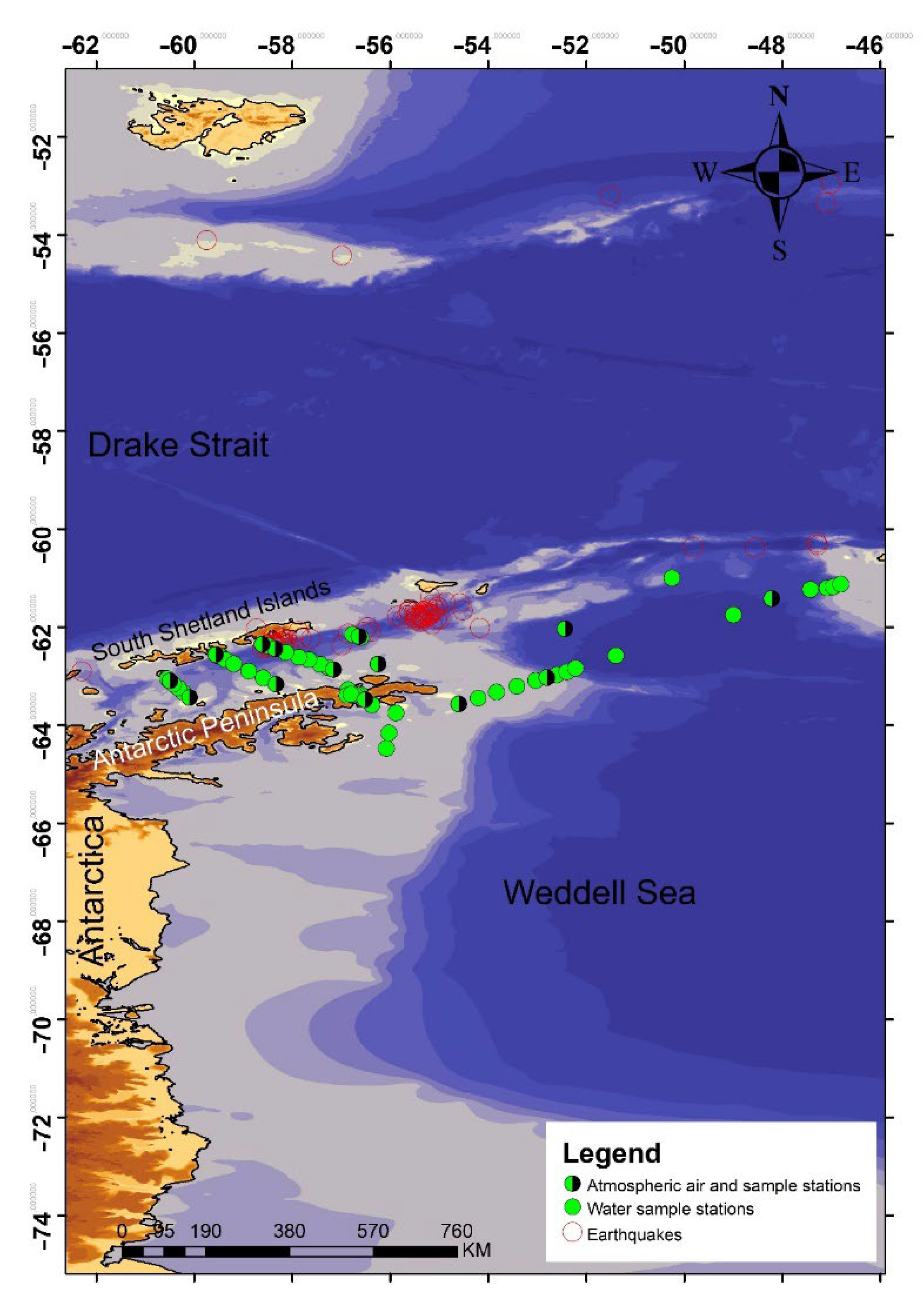
The Bransfield Strait is located in the southern Atlantic Ocean (Southern Ocean) between the archipelago of the South Shetland Islands and the Antarctic Peninsula. The southwestern part of the strait is bounded by the Gerlash Strait. The extended deep-water section, reaching 1500 m depth, abruptly passes into the shallow shelf zone of the South Shetland Islands and the Antarctic Peninsula with a depth of 300 to 700 m. According to modern studies, the strait enters a rift zone marked by increased seismic activity, while the central part of the strait is characterized by a sharp decrease in relief, probably of tectonic or volcanic-tectonic nature [
20]. The South Shetland Islands are of volcanic origin, while there are areas of recent activity in this area, for example, the Deception Island caldera [
21]. Generalization of the results of complex geological and geophysical studies in the Southern Ocean, in particular in the area of its junction with the Atlantic Ocean, shows that this region is the area of existence of large fragments of the destroyed intercontinental bridge between South America and West Antarctica, which has experienced cracking and local rift spreading. The dynamics of its development was determined by the heating of the lithosphere under the influence of extensive uplift of mantle matter (plume) in conditions of moderate separation between the continental massifs of South America and West Antarctica. This was accompanied by regional magmatism of the type of areal oceanic platobasalts, local magmatism (such as SOX basalts) in young local rifts, crushing and collapse of crustal blocks in the Drake Strait, as well as sequential immersion of such blocks in the basin of the Scotia Sea.
Brief hydrological characteristics of the research area Bransfield Strait meets a collision of warm waters of the Atlantic Circumpolar Current (ACC) penetrating through the deep straits between the islands of Brabant, Lowe and Smith, and cold surface waters of the Weddell Sea entering the Bransfield Strait through the Antarctic Sound and the shelf zone of Joinville Island [
22,
23,
24]. The interaction of the waters of the ACC and the waters of the Weddell Sea results in the formation of a coastal boundary current in the Bransfield Strait, directed along the southern coast of the South Shetland Islands to the northeast. The boundary current of the Bransfield Strait has a significant impact on the physicochemical properties of water in this area and participates in the transfer of biogenic elements [
25] necessary for the development of marine biota at all trophic levels. This area has an important bioresource value, since it is the area where the growth and development of Antarctic krill to adults takes place. Krill is an important ecosystem link in the Southern Ocean, representing a food source for many species of fish, penguins and marine mammals [
26]. During the Australian summer (December–February), the water area of the Bransfield Strait is free of ice cover, there are practically no icebergs and large fragments of ice that interfere with navigation, which makes the Strait a convenient testing ground for a number of geological, oceanological and hydrobiological studies of this part of the Southern Ocean.
3.1. Bransfield Strait
Located between the South Shetland Islands and the Antarctic Peninsula, the Bransfield Strait has an asymmetric cross-section and consists of (from north to south): a narrow (less than 10 km) shelf zone, a deep-water central basin with a width of 15–20 to 80 km (
Figure 1) and the wide shelf of the Antarctic Peninsula (the Bransfield platform).
The Bransfield Strait meets a particular interest as a rift zone with increased seismic and modern volcanic activity, as well as an area with recently discovered areas of hydrothermal activity. Earlier, the study of methane distribution profiles in the water column of the Bransfield Strait was carried out in a limited volume in its western part, and the main attention of researchers was focused on analyzing the patterns of methane distribution in the Weddell Sea.
The western part of the Bransfield Strait, with a strong coastal influence and extensive shelf zones, are considered as highly productive areas [
28]. Wefer et al. (1988) [
29] associated these regions with episodic high production events and documented very high fluxes of settling material to the sediment in the Bransfield Strait.
The Bransfield Strait is of a particular interest as a rift zone with increased seismic and modern volcanic activity, as well as an area with recently discovered areas of hydrothermal activity. Earlier, the study of methane distribution profiles in the water column of the Bransfield Strait was carried out in a limited volume in its western part, and the main attention of researchers was focused on analyzing the patterns of methane distribution in the Weddell Sea.
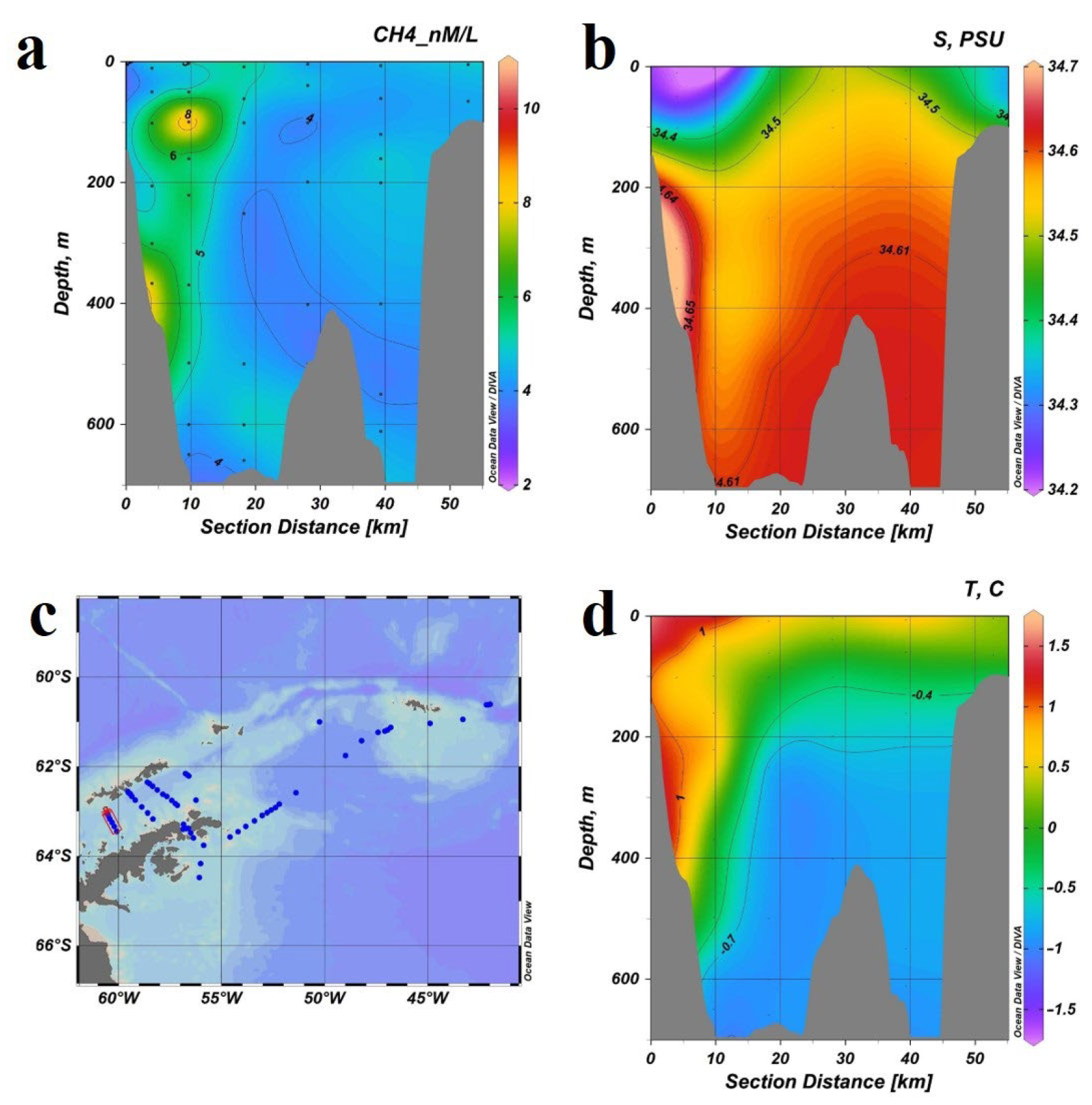
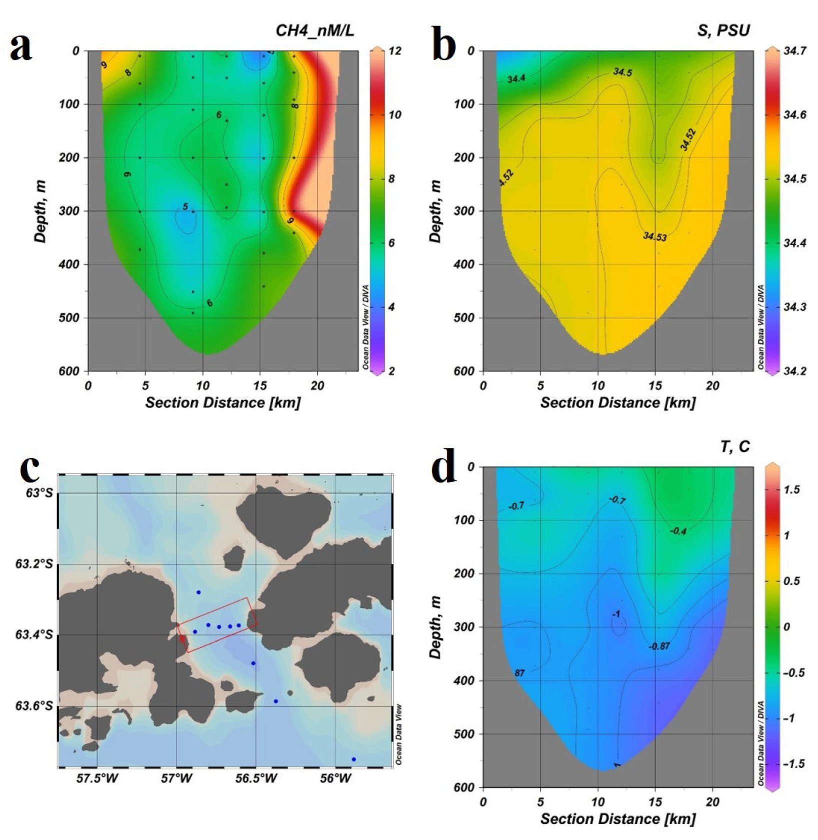
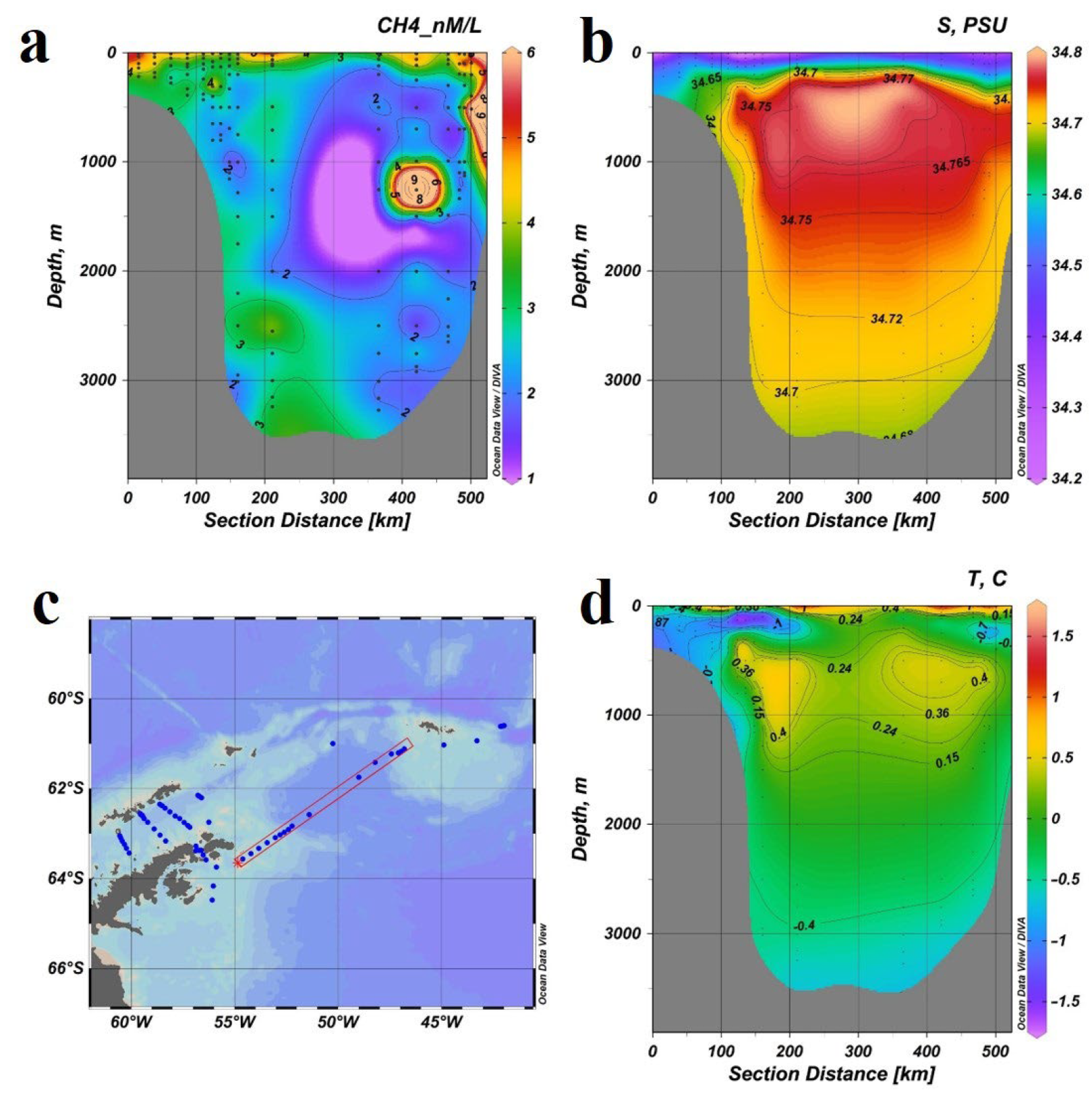
During cruise 87 of the R/V “Akademik Mstislav Keldysh”, 7 December 2021–5 April 2022 (AMK87), 3 sections were made in the Bransfield Strait, including 24 gas-geochemical stations (200 samples). Analysis of seawater samples taken from bathometers in the depth range 2–1767 m revealed methane concentrations of 2.47–10.95 nM/L (
Figure 2,
Figure 3 and
Figure 4).
The maximum methane concentrations (10.95 nM/L) are observed on the slope of the trough of the Strait near the South Shetland Islands in the eastern (
Figure 4a,c) and central (
Figure 4c and
Figure 5a) sections at the horizons of 0–500m.
Figure 2a,
Figure 3a and
Figure 4a clearly show a core of elevated methane concentrations centered at a depth of 400 m and having a horizontal scale of about 10 km. This may be due to the transfer of methane-saturated waters by the Bransfield Strait current, directed to the East. The presence of this jet carrying elevated concentrations of methane is confirmed by temperature (
Figure 2d,
Figure 3d and
Figure 4d) and salinity (
Figure 2b,
Figure 3b and
Figure 4b) data.
In the surface and subsurface (depth of 0–200 m) water layers in the central and eastern sections (
Figure 3a and
Figure 4a), an area of increased concentrations (7.63 nm/L) is allocated, which may also be associated with the hydrological regime—the existence of vortices on the central axis of the strait (
Figure 5).
The minimum methane concentrations (2.47 nm/L) were found at the bottom of the strait—in a water layer with a depth of more than 1000 m (
Figure 2,
Figure 3 and
Figure 4), which may be caused by the transit of Deep Water of the Bransfield Strait (GWB), the upper limit of its distribution is considered to be the values of potential temperature −1.0 °C and salinity 34.5 eps [
31].
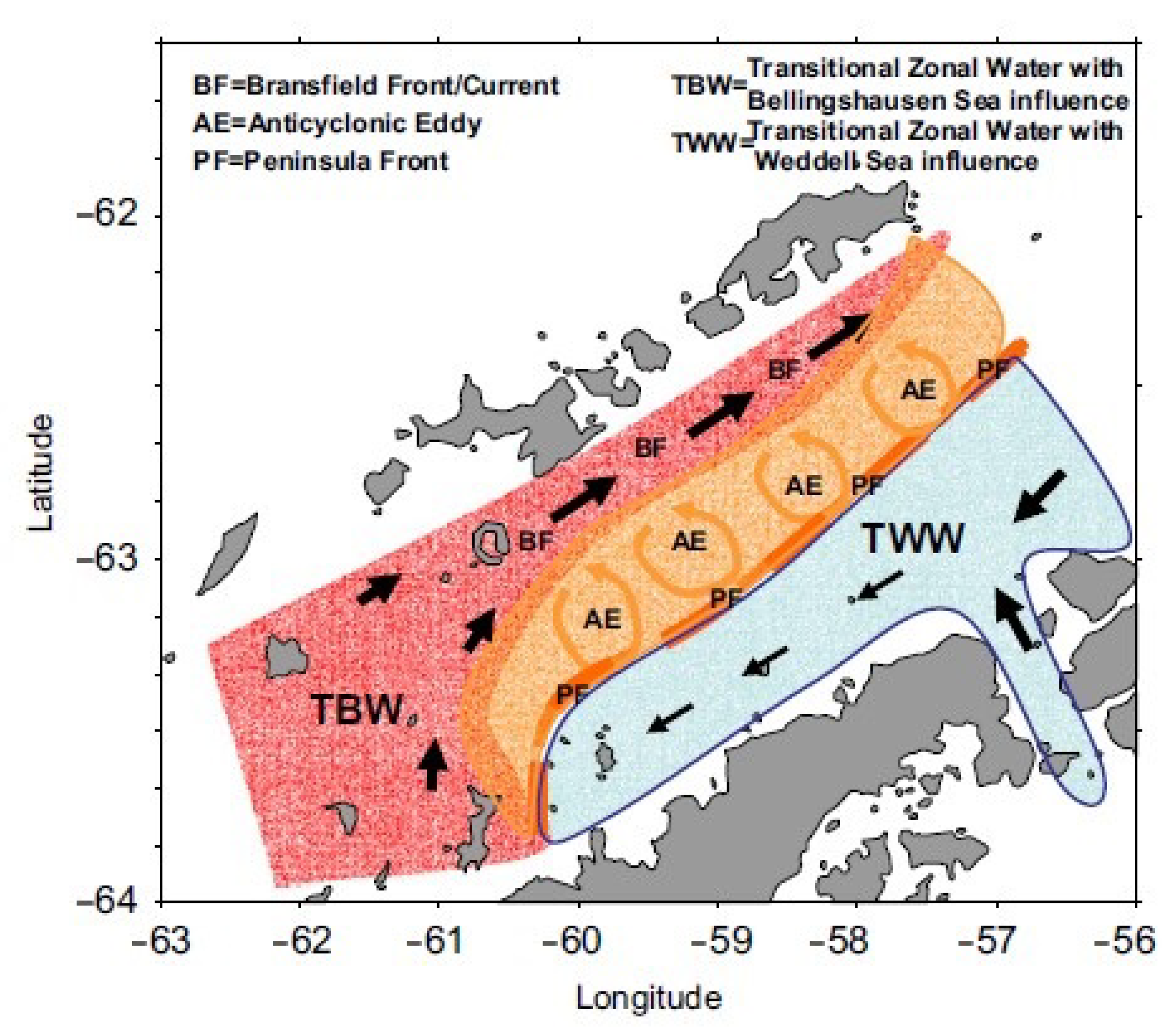
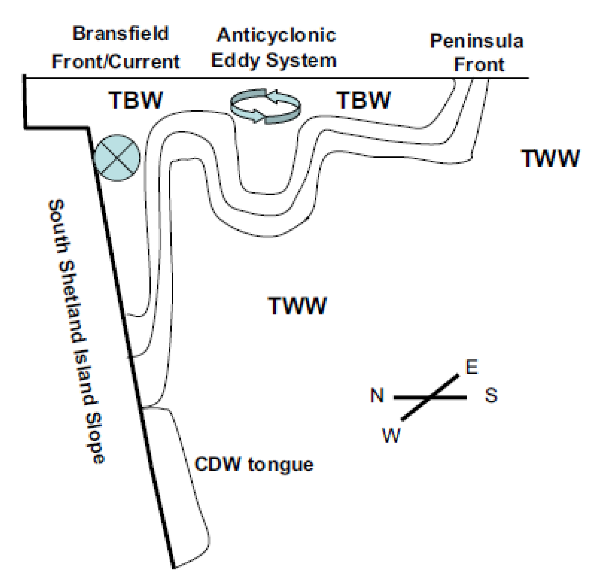
The methane concentration distribution in the Bransfield Strait is largely controlled by the hydrological regime, the scheme of methane transit at different horizons through the strait is confirmed by modern hydrological studies [
32], as well as studies of Russian and foreign colleagues in previous periods [
22,
30,
31,
32], the flow diagram of the strait in the section is shown in
Figure 6.
The central section of the Strait (
Figure 3c) geographically repeated the section made during the expedition 79 of the R/V “Akademik Mstislav Keldysh”, 2020. Gas-geochemical studies of 2020 revealed a zone of increased concentrations of methane at the bottom of the strait, a local gas discharge site of hydrothermal nature associated with a fault system at coordinates 62°40′3″ S. 59°21′40″ W. [
33]. Our paper describes that a methane-containing hydrothermal fluid causes an increase of the methane content in sea water from 10 to 43 nmol/L in a wide range of depths of the water column. The bottom water layer with a high methane content extends over considerable distances from the hydrothermal outlet. Additionally, the largest number of thermophilic methanotrophic bacteria found in the bottom water layer was found at this site. The detection of thermophilic microorganisms in the bottom layer confirms the endogenous nature of the methane source [
34].
However, the cruise 87 of the R/V “Academik Mstislav Keldysh” (2021–2022) did not detect this anomaly or any result of its activity. The instability of the endogenous sources of the strait is probably controlled by the seismic situation of the region and needs further study.
3.2. Antarctic Sound
Analysis of seawater samples taken from bathometers in the Antarctic Sound The analyses showed a different distribution of methane (
Figure 7a and
Figure 8a). In the Antarctic Sound 7 hydrological stations (52 samples) were carried out at horizons of 4–949m, forming 2 sections:) across (
Figure 7c) and along (
Figure 8c) the sound. The cross section between the Antarctic Peninsula and Joinville Island is characterized by elevated methane concentrations (
Figure 7a) at the extreme eastern (7.28–11.4 nm/L) and western (5.78–7.93 nm/L). The main water mass of the central part of the sound contains average methane concentrations (4.11–6.55 nm/L) unevenly distributed in the water column (
Figure 7a).
A local bottom field of elevated methane concentrations (up to 7.33 nM/L) (
Figure 8a), which presents here probably due to endogenous processes was revealed on the longitudinal section (
Figure 8c). This area of elevated concentrations was also determined during the 79th cruise of R/V “Academik Mstislav Keldysh”, 2020 [
33].
The most important result of the research in the Antarctic Sound is the discovery of a constant stable zone with an increased concentration of methane in the bottom water layer in the deep part of the Sound. It is likely that the increase of the methane concentration in the bottom water layer is associated with the movement of water masses from the deep-water part of the Antarctic Sound, where there are not yet mapped areas of gas discharge spots.
The Antarctic Sound transports water masses with low concentrations of methane from the Weddell Sea to the Bransfield Strait [
33], where these waters spread westward along the Antarctic Peninsula (see
Figure 5) and form methane transit fields.
Figure 7b,d and
Figure 8b,d show the transit of cold (−0.7–−0.4 °C) waters with “low” (34.5 psu) salinity from the Weddell Sea to the Bransfield Strait (
Figure 2b,d,
Figure 3b,d and
Figure 4b,d).
3.3. Weddell Sea
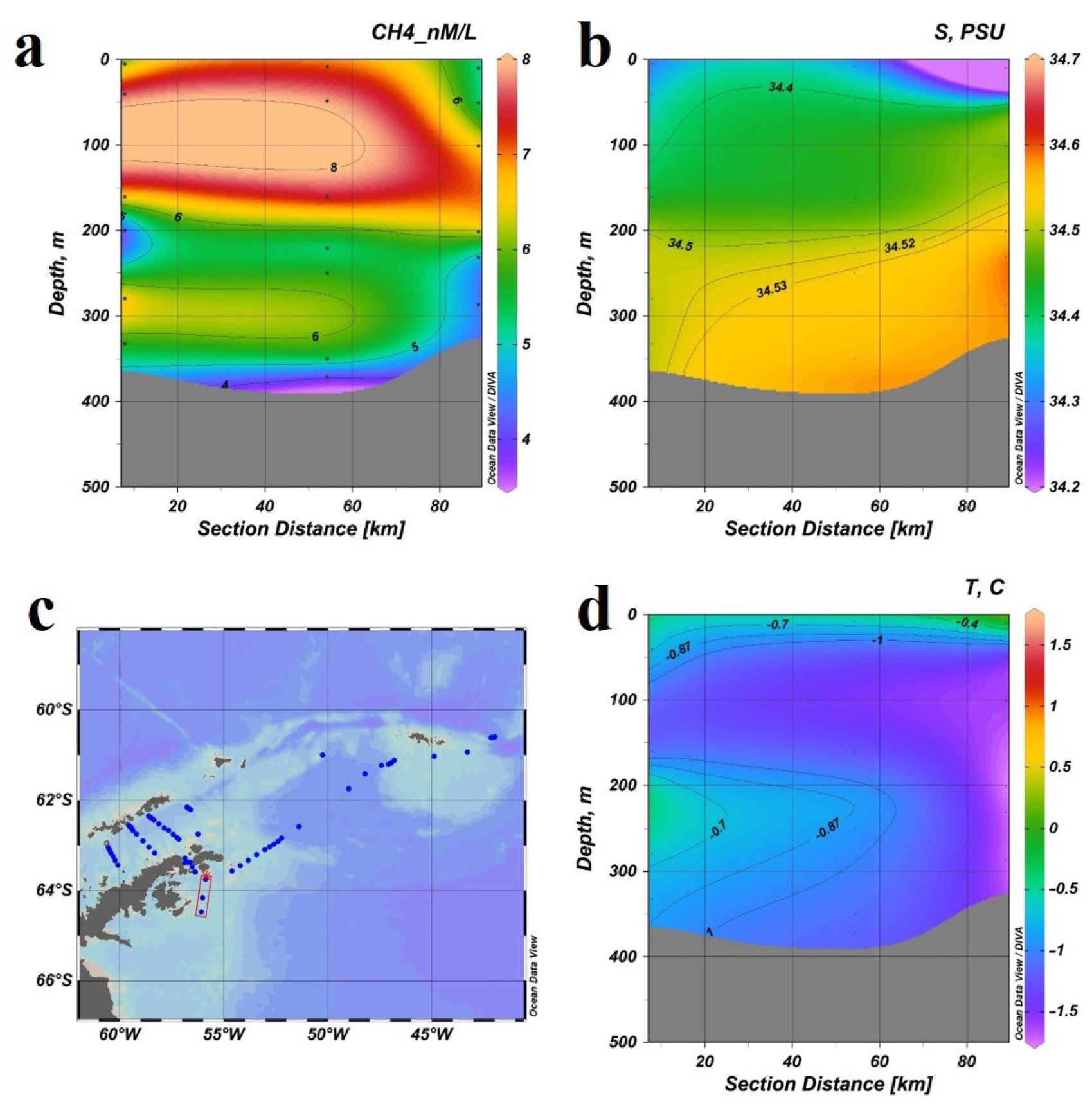
A section (about 80 km) of 3 hydrological CTD stations was made in the Weddell Sea in the direction south of the Antarctic Sound (
Figure 9c), the depth range was 5–371 m, 19 samples were taken.
The section distinguishes 3 layers: two—with increased methane concentrations (0–200 m and 250–350 m) and a bottom layer of low methane concentrations (
Figure 9a) in cold subzero waters (
Figure 9b) of “low” salinity about 34.5psu (
Figure 9b).
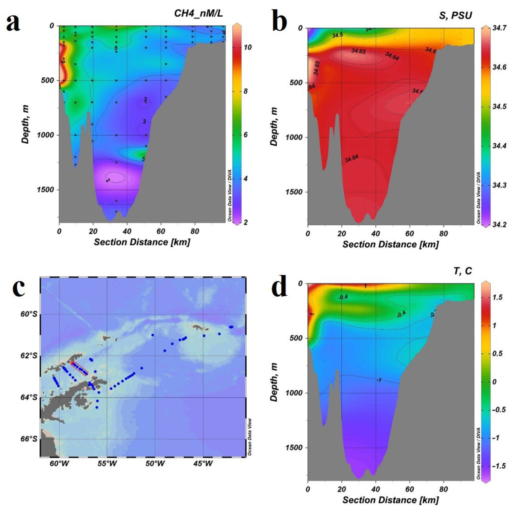
A 500 km section (
Figure 10c) was made through the Weddell Sea (63.6° S, 54.6° E–61.1° S, 46.8° E), the depth range was 11–3270 m, including 16 hydrological stations (135 samples). As gas-geochemical studies have shown (
Figure 10a) that the main body of water is characterized by low concentrations of methane (1.56–3.45 nm/L) observed in the deep-water part of the basin, and its western part is deeper than the isobate of 2000 m has slightly higher values (up to 3.95 nm/L) compared with the eastern one. Average concentrations are observed in the surface water layer. At the extreme eastern station of the section, elevated concentrations of methane were recorded (8.95 nm/L in the bottom layer of 516 m and 6.5 nm/L in the layer of 10–200 m); however, at the horizon of 396 m, the concentration of methane was 2.8 nm/L, which may be caused by the influence of an undercurrent, confirmed by temperature drop (
Figure 10d), existing under the subsurface layer of low salinity (
Figure 10b).
3.4. Methane in the Atmosphere
The Southern Ocean is one of the most biologically productive oceanic regions in the world and characterized by high biomasses of zooplankton, Antarctic krill, and salps [
35], all of which having the potential to produce CH
4. Although some researchers have measured CH
4 concentrations in the Southern Ocean [
36,
37,
38,
39,
40], accurate assessment of the sea–air flux of CH
4 has been limited by the sparsity of available data.
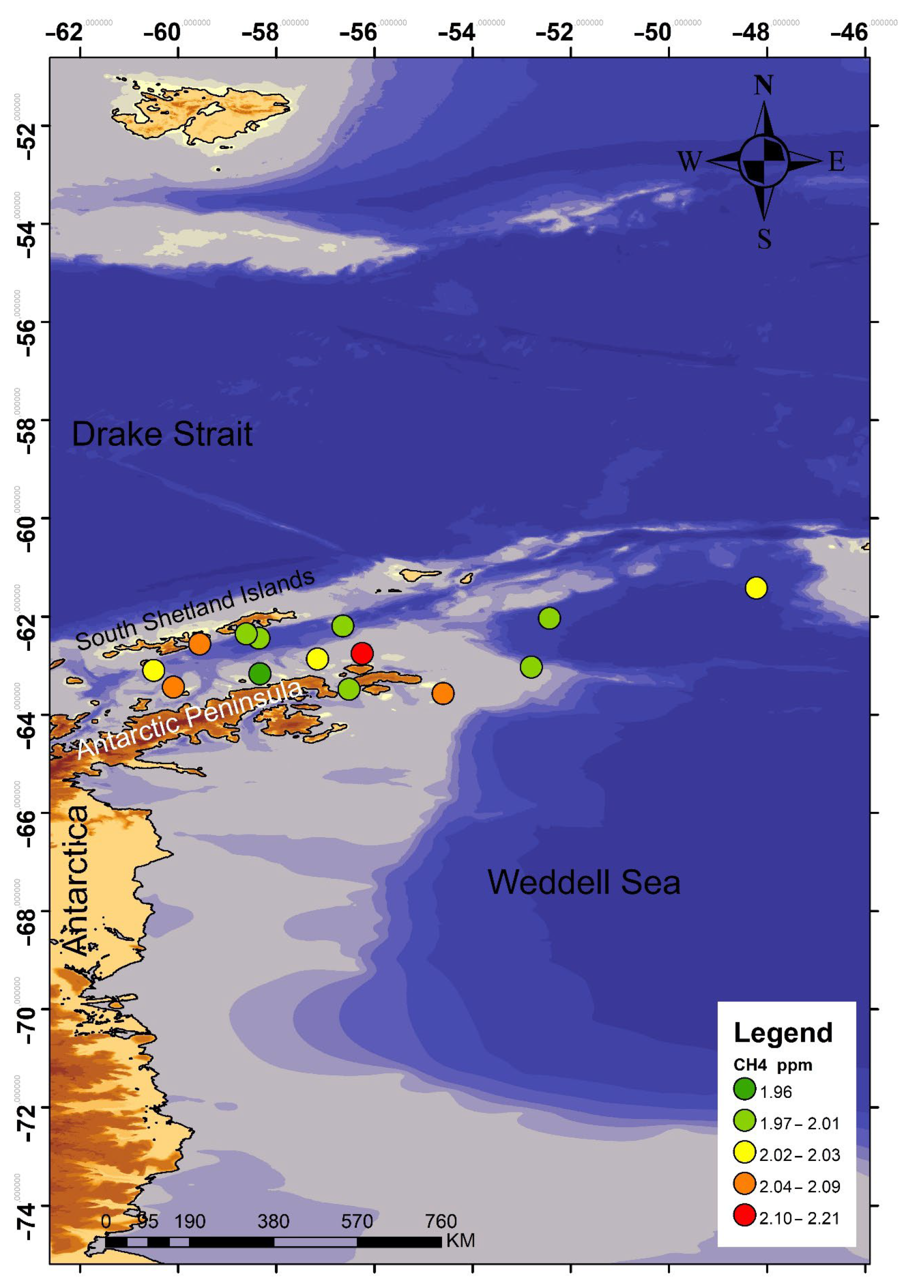
We have taken 14 samples of atmospheric air on the study area (
Figure 11). The range of methane concentration was 1.96–2.24 ppm. It is a rather high value, as a global atmospheric CH
4 level is about 1.9 ppm according to [
41,
42].
Despite low methane mole fraction in the atmosphere (1.803 ppm in 2011), CH
4 is the second largest contributor (17%, after carbon dioxide) to the total radiative forcing caused by the well-mixed greenhouse gases [
43]. The continuous increase of atmospheric CH
4 in the past decades implies an imbalance between CH
4 sources and sinks and prompts urgent questions about the causes [
44].
Atmospheric methane concentrations are probably controlled by active volcanism and wind regime of the region and are a sphere of the further research. Gille et al. (2014) [
45] reported that low temperatures of the surface waters in the Kerguelen region correlate with high wind speeds, and that wind-mixing of the upper ocean there resulted in entrainment of cold water into the mixed layer and euphotic zone [
46].
In the Southern Ocean, strong vertical mixing is induced by near-surface westerly winds that causes convergent flow at intermediate depths; such mixing partially offsets upwelling [
47]. The flow of methane into the atmosphere from the sea surface is controlled not only by physical factors, but also by the availability of organic matter and oxygen [
48].
4. Discussion
During the research in the Southern Ocean as part of cruise 87 of the R/V “Academik Mstislav Keldysh”, 7 December 2021–5 April 2022, local anomalies of methane concentrations and their sources were not detected. The vast majority of the water mass is characterized by low concentrations of methane, which indicates the absence of intensive and stable endogenous methane sources. In general, the area is characterized by low rates of methane synthesis and oxidation. At all stations, bacterial utilization of methane prevailed over its synthesis, which indicates the presence of a permanent source of methane [
34].
The stable methane emission sources presence assumption was substantiated earlier basing on the fact, that Bransfield Strait is located between the archipelago of the South Shetland Islands and the Antarctic Peninsula. It is of particular interest as a rift zone with increased seismic and modern volcanic activity, which are expressed in a special gas-geochemical regime. The most important result of the Antarctic Strait research is the discovery of a stable zone with an increased methane concentration on two sections in the sea bottom layer in the deep part of the Strait, which is associated with the movement of water masses from the deep part of the Antarctic Strait, where there are not yet mapped areas of bottom gas discharge. A single methane sip was detected at a depth of 1397 m, characterized by a high level of methane content (43 nmol/L) in the bottom water horizon. It was also found that the methane-enriched (10.29–14.46 nmol/L) bottom layer of seawater extends to a distance of 30–35 km from the central part of the methane anomaly [
49]
Most currently active Antarctic volcanoes are controlled by the West Antarctic Rift System (WARS). Three of them are located on Victoria Land (Mount Erebus, Mount Melbourne and Mount Rittman), and the fourth is Deception Island in the South Shetland Islands group, located in the Bransfield Strait.
It is likely that the observed by us in 2022 increased methane concentration is related to the water masses transfer from the deep-water part of the Antarctic Sound, where there are areas of gas emission on the bottom could occurs.
Thus, a comparison of gas-geochemical, hydrological and microbiological data indicates the absence of a permanent active focused source of methane at the bottom of the Bransfield Strait.
Apparently, the new source of elevated methane concentrations at the bottom of the Bransfield Strait, discovered in the cruise 79 of R/V “Academik Mstislav Keldysh”, is local and unstable one and is associated with a gas discharge site, most likely representing a hydrothermal outlet. The methane anomaly found [
33] is associated with endogenous processes in the riftogenic seismically active zone, and the localization of the source is due to the peculiarities of the tectonic structure of the bottom of the Bransfield Strait and requires more detailed further study. According to the data obtained, it can be concluded that in the Atlantic sector of the Southern Ocean there may be areas of rapid and long-range transport of anomalous methane fields in the water column, possibly up to the surface.
Studies of gas-geochemical fields of the bottom water layer provide the most accurate detection of jet methane outputs from bottom sediments. In connection with the above results, one can assume that in the Atlantic sector of the Southern Ocean there may be areas of long-range transit of anomalous methane fields in the water column laterally. Methane can achieve the surface water layer just with a powerful bubble jet. Their height sometimes reaches 2 km in different areas of the World Ocean [
50]. Therefore, further gas-geochemical studies in this region remain highly relevant and it can be concluded that systematic complex expeditionary studies are required. Low regional activity of lithosphere gas discharge made it possible to study the distribution pattern of methane dissolved in water and its transit through a complex system of currents of the studied region. As a result, the location of dissolved methane particles is controlled by a complex hydrological regime of the region: the transit of water masses from the Weddell Sea through the Antarctic Strait to the Bransfield Strait, circulation in the Bransfield Strait (vortices of the central axis of the Strait, a stream along the South Shetland Islands).
5. Conclusions
Climate changes and the chemical composition of the atmosphere result in global changes process of the World Ocean. Oceans play a key role in climate regulation, especially in buffering (neutralizing) the effects of increasing levels of greenhouse gases in the atmosphere and rising global temperatures. The regulatory processes carried out by the oceans alter as a response to climate change, and positive feedbacks to the ocean may exacerbate climate change.
The author’s research has shown that the processes causing these changes is directly affected by many characteristics of the waters of the Southern Ocean, especially the Atlantic sector. This, in turn, has a strong impact on the state of the ecosystem of this important fishing area. Complex and active hydrodynamics caused by the Antarctic circumpolar current, intense vertical circulation, orographic barriers, the development of contrasting fronts, areas of demolition of terrigenous material with signs of chemical anomalies, etc. This has led to the fact that conducting complex oceanological studies to assess the current state of the Southern Ocean environment at the junction of disciplines has allowed us to obtain a number of important and unique scientific results.
Detailed gas-geochemical studies have been carried out and methane concentrations in the water column of the Bransfield Strait and Antarctica have been studied. A study of the Bransfield Strait area, where a local bottom-level methane anomaly was detected in 2020, showed the absence of elevated concentrations, which may indicate a high intensity of the “biological filter”, as well as instability of the lithosphere discharge. During the expedition, no active sources of methane output were found, which made it possible to assess the influence of currents on the distribution of methane fields in the water column and to outline prospects for further research. The increased values of methane concentration in the atmosphere of the Southern Ocean indicate a significant contribution of the region to the global debit of greenhouse gases, which implies further careful study of the sources of gas discharge not only in the water area, but also in the land areas of Antarctica.
It is advisable to carry out a complex of geological and geophysical studies of the sea bottom, including lithological testing, geochemical, hydroacoustic and bathymetric studies of the bottom ecosystem in the subsequent stages of research of the ecosystem of the Atlantic sector of the Southern Ocean.


