

Learning from Floods—How a Community Develops Future Resilience
School of Built Environment, College of Science, Massey University, Auckland 0632, New Zealand
*
Author to whom correspondence should be addressed.
Water 2022, 14(20), 3238; https://doi.org/10.3390/w14203238
Submission received: 31 August 2022
/
Revised: 8 October 2022
/
Accepted: 12 October 2022
/
Published: 14 October 2022
(This article belongs to the Special Issue Flood Risk Management and Resilience)
Abstract
:Settlements close to rivers, the sea, and hills are among those most vulnerable to floods. The hilly terrain region experiences higher rainfall than the lowlands due to the orographic effect. As a result, excessive rains feeding major rivers cause a rapid rise in water level resulting in frequent breaks of the riverbanks. The flood hence covers the inhabited lowlands with water and silt, causing loss of lives and properties. The affected communities need practical coping alternatives to deal with the intensity and the increasing exposure to floods. The Sustainable Development Goals (SDG6) identify the sustainable management of water and sanitation as one of their key objectives. This study identifies resilience in practice focusing on how communities create resilience and develop sustainable river catchment management. A qualitative method was used, involving observations, interviews, and community surveys with one of the most flood-prone populations, the New Zealand Northland community. A desktop study containing government publications and flood records compliments the thematic analysis result and strengthens the discussions. Social connections, participation in self-protection training, and maintaining the catchment were among the main findings of the study. This study recommends for community-led response plans integrated with infrastructure improvements and collaboration with councils to reduce the risk of future floods.
1. Introduction
Floods are the world’s most common disaster, and climate change has detectably influenced several water-related variables that increase the hazard risk, jeopardising the ecosystem, built environment, and human lives [1]. With over a hundred cities and towns located on flood plains, New Zealand has a long history of living with floods. Making decisions on how best to protect life and property from floods is an ongoing challenge. However, due to climate change, the number of flood hazards and communities at risk is expected to increase [2]. The changing patterns of risk exposure have led to a growing understanding that flood risk cannot be eliminated, and structural flood defences do not guarantee communities’ resilience [3,4]. Through this understanding, New Zealand manages its current flood risk by adapting to future climate change, including focusing on risk management and resilience building (reductions and readiness) rather than crisis management (response) and recurring recovery [5,6].
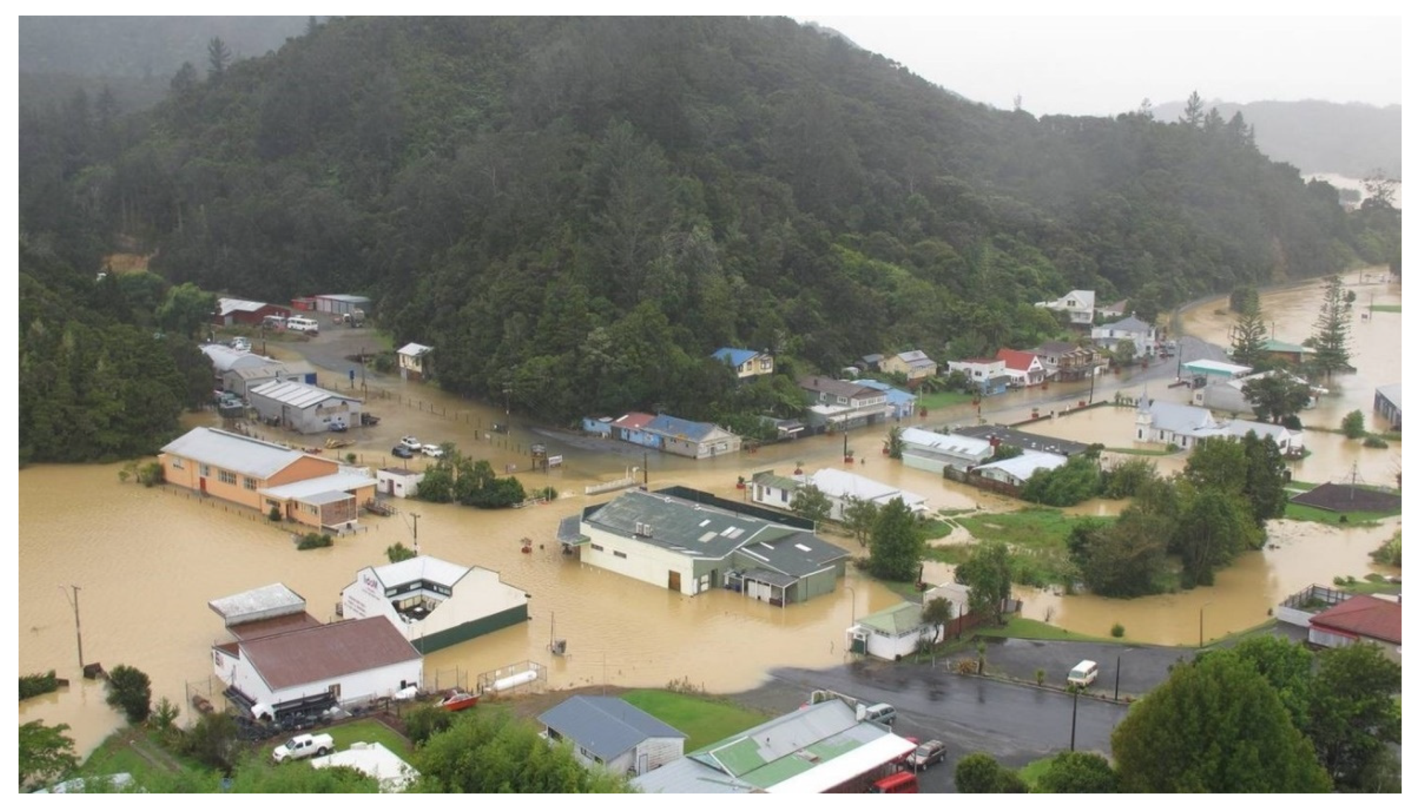
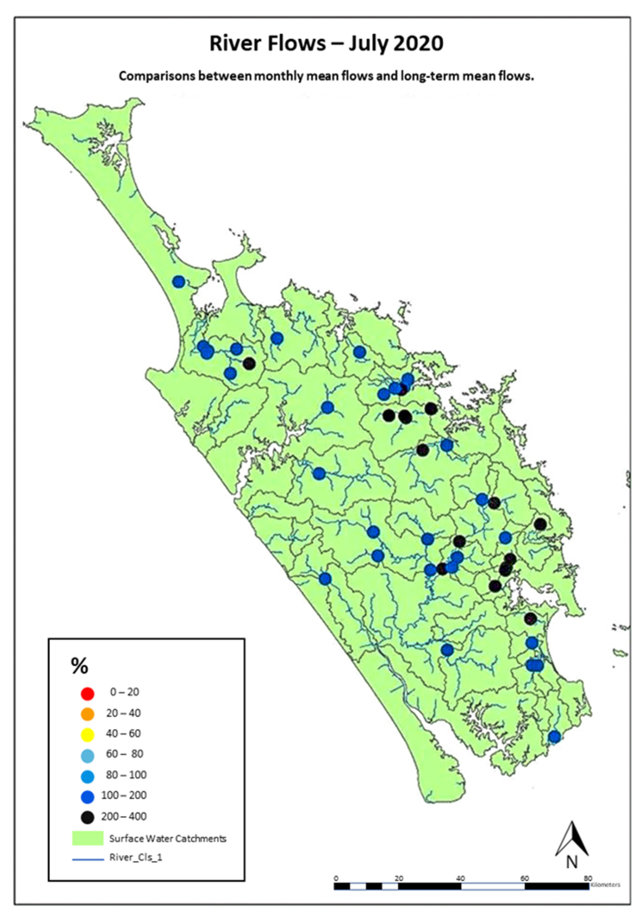
Recurring flood has significantly impacted many townships in the region, especially towns in the low-lying areas, due to the orographic effect, river rise, and development in the floodplain (see Figure 1). As seen in Figure 1, the flooded area is confined between two hills, creating no outlet for high water to escape. Northland rivers tend to have a low normal flow but can rise very quickly with rain, overflow their banks, and cause flooding [7]. During the 15–18 July 2020 storm, there was a one-in-500-year flood event. According to Northland Climate Report 2020, river flows were up to 400% above normal in many rivers along the east coast, with the remaining catchments reaching 100–200% (see map in Figure 2) compared to long-term averages of 40–60% during normal conditions [8]. Another flood and landslip occurred in Kaeo, Kerikeri, and Kawakawa in July 2021 and another flood in 2022 [9,10]. These floods collectively affected people, road infrastructure, safety, and floodplain settlements. Recovery is still ongoing from the recent floods, and preparations for the next flood are already underway.
Flood hazard is not new to the local communities as it has been there for thousands of years [11]. The resilience to floods was first time recorded in 1863 when the colonial settlers faced flood hazards and documented the resilience of the indigenous community to floods [11]. Flood resilience can be defined as being prepared, ready to respond, and able to cope and recover from a flood event [12,13]. Resilience is not only about the capacity to bounce back to the original state after adversity but also about advancing in it by learning from past experiences and adaptation [14]. Resilience strategies focus on reducing the impacts of floods through better prevention and preparedness [15]. There is a saying in Māori that underpins the strength of communities: “Hei aha te mea nui i tenei Ao? He tangata, he tangata, he tangata—What is the greatest thing in the world? It is people, it is community” [16]. Following that pearl of wisdom, increasing community resilience may decrease the impacts of a hazard. Therefore, building community resilience has become one of the fundamental techniques for dealing with floods in New Zealand’s local councils [17].
A thriving and empowered community is the cornerstone of the local council’s community resilience plan, especially in Northland [16]. Due to the interdisciplinary nature of resilience, top-down and bottom-up FRM approaches need to be integrated [13]. In practice, however, communities still rely more on their traditional understanding and techniques to recover from disasters, even though the government has defined and planned flood management guidelines. The local community in Northland has developed their own concept of resilience and uses its own strategy to overcome adversity. This study aimed to understand how Northland’s community understands what to do when flooding occurs and how to prepare more generally for natural disasters and climate change. As part of the process, a literature review was conducted, data collection and analysis methods were prepared, and the results were discussed to formulate the conclusion. A significant outcome of this study is that it identifies ways for communities to learn from past floods and how they use this knowledge to improve their resilience in the future.
2. Background Literature
Flood risk management has been practised across the globe for decades. The Sustainable Development Goals (SDG6) [18] include the provision to support and strengthen the participation of local communities in improving water and sanitation management [19]. However, implementation remains challenging to achieve [20]. Understanding flood risk management includes understanding the consequences that come with the risk and developing strategies to minimise or mitigate the risk [21]. Regarding risk reduction efforts, resilience and adaptive capacity decrease the negative consequences of flood risk. Adaptive capacity refers to the ability of a community to adjust to potential damage by the recurring flood and climate change, learn, and take any opportunity to cope with the consequences [13,22]. Additionally, understanding the dynamic and interrelation of Source-Pathway-Receptor-Consequences (SPRC) models [23] helps to improve flood risk resilience.
2.1. The Concept of Flood Risk
Flood risk can be modelled using the Source-Pathway-Receptor-Consequences-Model (SPRC-Model) [23,24] which demonstrates an essential chain that runs from meteorological and hydrological events (Sources) on the inland or at the coastlines (Pathways) to the physical impacts on components at risk (Receptors) and the evaluation of effects (Consequences) [23,24]. The chain represents the physical process that links Source, Route, and Receptor, while the judgement of the Negative Consequence is a subject of social values.
In particular, the source is defined by the likelihood of flood episodes caused by torrential rain or high weather events [25] and the risk is reduced by interventions such as early warning systems [26,27] and the retention capacity of in-land floods [28]. The path is described by river or coastal overflow and flooding [23] with diverse qualities and decreased by flood control intervention. The receptors determine susceptibility with interventions from efforts to promote resilience and increase resistance [29,30]. The consequences represent the damages and are reduced by attempting to decrease or compensate for the damages values [30].
The chain of SPRC-Model occurs for each element at risk and flood hazard [23]. A complex interrelation exists, and a system that includes all related features and processes can be called a flood risk system [23,31]. In the system, there are the hazard which is flood, probability which is estimation of flood occurrence and exposure, which is the increased risk of flooding due to development in floodplain areas. People and assets are often exposed to the risk of floods due to an uninformed community and poor risk communication [32,33]. Facing natural disturbances such as floods are perceived to have an essential source of resilience-building knowledge for the community [22]. As a result, assisting the community in preparing for future floods and giving resources to expand capacity by providing guidance will safeguard assets such as property [34,35] and infrastructure [36] and reduce the impacts on health, discomfort, and trauma [37].
2.2. Response and Recover from Floods
Inland flood retention capacity, flood control, resilience, and compensation are all viewed as forms of flood management. Compensation here is the reduction of the negative consequences of floods and acts of protection, such as insurance against flood damages or repayment to flood victims [30]. However, flood risk cannot be avoided in New Zealand [38,39]. There will always be some level of risk, regardless of whether risk reduction measures are implemented or strengthened [5,31]. Floods can affect several catchments or regions, affecting several communities simultaneously. During floods, the government directs people not to wait for official warnings; instead, they are advised to head to higher ground and stay away from floodwater [40,41]. In addition to flood information, the central government provides a web platform for flood response and recovery, including food safety, livestock safety, road conditions, and weather warnings and forecasts. Flood response is an action taken immediately before, during, or directly after an emergency to save lives, protect property, and help communities recover [42]. In response to a disaster, recovery refers to coordinated efforts and processes to rehabilitate and enhance a community holistically [42]. The recovery action involves restoring, redeveloping, and revitalising flood-affected communities.
The disaster response level is determined by the event’s severity, complexity, and consequences (see Table 1). Generally, when higher response levels are activated in New Zealand, the government either assumes overall responsibility for the incident or supports the response of other agencies [40,43]. In terms of the disaster response at the community level, local, regional, and national levels can be involved [42,44]. While planning for response and recovery, risk perception should be understood and owned by all groups as it is an essential component of building resiliency [45]. Thus, Northland has developed a Community Response Plan with the community representatives that are activated when facing emergencies, including flood events [46].
Despite having national and regional plans, there is no assurance that the community will follow the response plan during floods [4,47]. The reality of understanding the impact of a flood and the urgency of response and recovery is difficult to comprehend unless people have firsthand experience [41,48]. No matter how a flood occurs, the safety rule is the same: go for higher ground and stay out of the floodwaters [49,50]. The ability to adapt and learn over time allows for greater resilience in the community to cope with more significant, unpredictable flood events [13]. Having a plan can help diffuse the sense of crisis by knowing who is responsible for doing what and where to turn for help [51].
As an integral part of the risk reduction process, recovery is coordinated and planned to recognise the escalation of the impacts of an emergency. Recovery entails more than just rebuilding infrastructure. Shaw (2014) identified that recovery requires local community participation, community social capital, strong local governments, and a recovery framework [52]. Regardless of the size of the town or the nature of the catastrophe, the local government in New Zealand is responsible for managing an emergency. Adapting from the national emergency plan [40], the Northland Regional Council (NRC) recovery plan follows the national strategic planning and actively supports the national recovery manager.
Following the shift of focus in New Zealand towards risk management consisting of reduction and readiness approaches, a community-based action plan is usually prepared [53]. The action plan includes raising community awareness by building effective hazard risk communication [33,45,54], supporting the community from all backgrounds and financial abilities [55], and a guide for property level and small-scale businesses protection and repairing strategies [22,34,35], supporting local knowledge [56] and traditional practices whenever relevant [57,58]. Such a community-based approach empowers a community to take measures to achieve resilience from floods.
2.3. Community Response Plan (CRP)
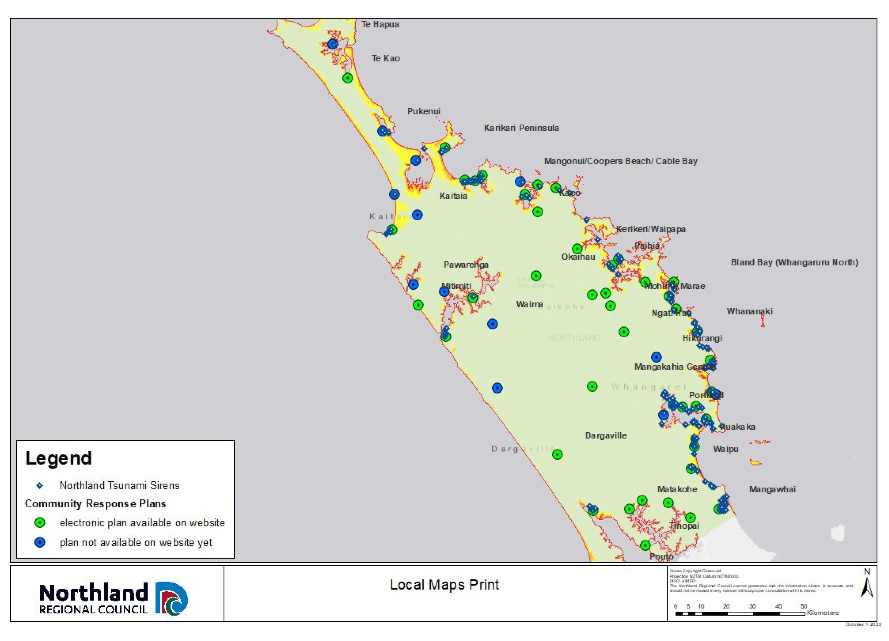
Many communities can become isolated during flooding in Northland, making self-reliance even more critical. To address these issues, Northland Civil Defence and Emergency Management have been working with local communities to develop Community Response Plans or CRP (see Appendix A Table A1). Moreover, 54 Community Response Plans have been completed over the past ten years, as seen in Figure 3. According to the Northland Regional Council, the CRP development process and the outcomes have been very successful [43].
Response plan objectives and information include hazard identification, communication strategies, and resource management [4]. In Northland, response plans assist communities in identifying hazards and risks and collectively understanding how they will handle future events [46], including assigning roles, responsibilities, and resources. Additionally, response plans assist communities in identifying local leaders or volunteers willing to be involved in and lead emergency management groups [51]. Emergency-related information is communicated to the community by the leader, and community concerns are relayed to the emergency group support structure of the local authority. Finally, response plans should outline the community’s resources and how they can be used in emergencies [44,46], such as communications, community-led centres, and physical equipment.
As a foundation for improving community resilience, The Northland Civil Defence and Emergency Management Group (CDEMG) has identified public education as one of its key priorities [43]. In addition to community response plans, Northland CDEMG has invested in Business Continuity Programs, Visitor Action Plans, and Vulnerable Group Projects [16,43]. A technological solution has also been developed to ensure that information for any emergency caused by weather occurrences is available on the website. Several existing networks have been utilised to support and leverage national initiatives, including Facebook, for disseminating information and educating the public. Northland CDEMG develops partnerships and strategic networks as they are seen as critical in creating message credibility and targeting vulnerable communities [43,59,60].
3. Research Methods
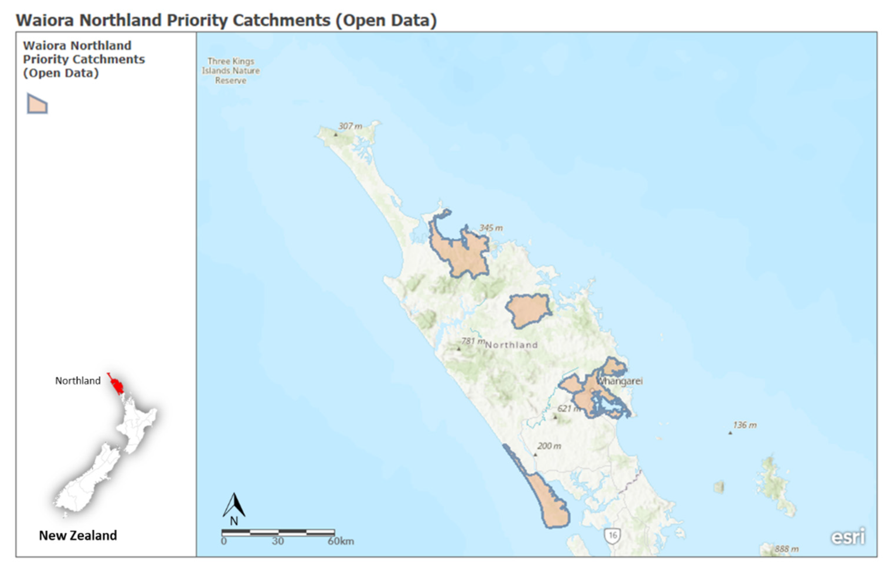
A study of floodplain communities was conducted in the Northland Region within the priority catchment, including Mangere, Doubtless Bay, Waitangi, Pouto, Whangarei, Ngunguru, and Hatea catchment (Figure 4). Due to the orographic effect, the Northland’s hilly terrain experiences higher rainfall than the lowland areas. As a result, excessive rains feeding major rivers cause a rapid rise in water level resulting in frequent breaks of the riverbanks. The breaks and overflowing river then rapidly approaching the lowland creates flash floods and significant inundation in the river floodplain. This study adopted various qualitative research methodologies to understand better the issues discussed above, including interviews, survey questionnaires, the analysis of documents and archives, and field observations. A qualitative approach was found to be the most prevalent method for measuring resilience [13]. This study uses a qualitative approach to answer questions about experience, meaning and understanding of actions’ underlying motivations [61]. Several techniques were employed to identify the interviewees, including snowballing techniques, setting up booths in community libraries, and networking through a gatekeeper in the community.
3.1. Interview and Surveys
Face-to-face and online interviews were conducted in June and July 2021. Participants for the interviews came from the agencies involved in flood management, members of the flood working group, residents of communities at risk, and members of the council of the study area. Key components of the interview included a focus on understanding community perceptions of resilience. All the responses were audio-recorded to ensure that the key participant views were accurately captured. A community survey with open-ended questions and satisfaction scale was distributed by opening information and survey booth in the local library and community centre. There are 185 surveys qualitatively analysed together with the interview results using thematic approach. A primary objective of this interview and survey was to investigate how these communities coped with the recurrent flood hazards.
3.2. Catchment Group Meeting and Field Observations
Three catchment group meetings were observed to understand how community address the issues to the government and other stakeholders. The relationship and interaction between community and different stakeholders are critically observed to understand the reason behind the community’s decision for flood protection and to see how the community take part in providing the solution. In terms of field observation, the researcher used the opportunity to inspect the study area while interviewing members of the flood working group and at-risk communities. The observations were conducted in July–August 2021 and August 2022, and the information recorded via photographs and note-taking.
3.3. Desktop Analysis
Desktop analysis enables the researcher to collect factual and interpretative information regarding implementation procedures. The analysis includes the documents from agencies such as local and regional councils (Whangarei District Council (WDC), Kaipara District Council (KDC), Far North District Council (FNDC), and Northland Regional Council (NRC)), the National Emergency Management Agency (NEMA), the National Institute of Water and Atmospheric Research (NIWA), and the New Zealand Red Cross. The data obtained were then triangulated to add credibility and internal validity to the findings and present a more comprehensive view of the research. The data collected from the desktop analysis were cross-checked against the data collected from interviews and site observations.
4. Result and Discussion
In order to understand how communities, develop resilience from floods, it is important to understand the vulnerability of communities to floods, and the flood impacts. There were no casualties from the major floods in the Northland in 2020, 2021 and 2022, but damage to homes, businesses, and infrastructure was extensive. Houses, public buildings, highways and bridges, water and sewer systems, and telecommunications were all affected. The ability of the Northland communities to implement a response plan and move quickly to recovery after the flood water drains out suggests that most residents are familiar with the flood hazard and are aware of the risk. However, lesson learned from flood experience does not always increase flood resilience [22]. Therefore, community engagement in the Northland region was developed to support community’s preparedness for recurring floods, including a catchment flood group meeting, Māori engagement, and a community response plan [43,44]. Such meetings reduce community vulnerability.
4.1. Flood Response and Recovery at the Community Level
Communities (such as in Kaihu, Taumarere, and Whangaroa river catchment area) with experience in past floods were able to respond faster than those that have not experienced flooding. However, community response and recovery also depended on knowledge and risk awareness. For example, during the floods in Far North and Whangarei in 2020, people without a proper understanding of responding to floods relatively chose to stay back in their houses despite the flood warning and instruction to evacuate.
In the Northland, people shelter in place (in the location they are already occupying-generally their homes) unless there is a mandatory evacuation. Communication between the affected residents and the relevant government agencies is crucial. This is because services such as evacuation and rescue operations and the setting up temporary shelters for the victims must be established immediately [14,30]. In flooded areas, the Northland Red Cross, Firefighters, Police, and Northland CDEMG are among the first organisations to arrive as they manage evacuations and operate temporary shelters. As long as there is communication and collaboration, community leaders, with the help of all the support organisations, contact all residents in their Whanau (community group) to ensure their safety.
Nevertheless, there are sometimes residents that either resisting to stay or not following the instruction to evacuate during an emergency, as seen at the flooding event in the Moerewa and Kaeo area of the Northland Storm Flooding, 17–18 July 2020. During the flooding event, some residents wanted to leave their homes for a safer place despite the instruction to stay put and the fact that driving on the flooded road is hazardous. In contrast, residents who need to be evacuated refused to leave for various reasons, such as being financially unable to move out, not having anywhere to evacuate, or fear of burglary.
People who have previously experienced flooding are generally more prepared, such as having food supplies and emptying the areas that could get flooded to minimise damage. Inexperienced people, however, are at greater risk of safety and vulnerability [47]. When a flood occurs, the affected areas can often become isolated (such as in most areas of the Far North district during 2020 flood and Kaitaia during 2022 flood) due to road closures, surface flooding, or road damage, and cleaning up will take some time. Community response plans for the flood regions [5,46], provided information including communication plans and infrastructure for emergencies, so communities had the tools to manage their safety [17,54]. The response plans also supported decision-making for emergency response [48] and established guidelines for flood survival [6,57] so the community was better prepared.
During flooding events, such as the 2020 and 2022 floods, emergency response teams were in high demand, for instance, to protect people, manage roads and evacuate vulnerable residents. First responders in these teams encouraged residents to look after the safety of their neighbours, especially the elderly and children. Community assets including a truck, boats, safe shelters, blankets, and other necessities were made available to the community, so that community members felt they could rely on their neighbours for assistance. Community resilience was demonstrated through sharing assets and concern for neighbors’ safety.
4.1.1. Volunteer
Resilience can be demonstrated through the availability and willingness of volunteers in the community to respond when needed. Volunteers play an essential role in the Northland during floods. Whenever possible, Regional CDEMG offers guidance and support to community-led recovery efforts. Taking part in the response and recovery process, the community demonstrates Whakawhanaungatanga (establishing relationships) and Manaakitanga (showing respect, generosity, and care to those who use services, their families and communities) [40,57]. Three types of volunteer groups are included in the Northland CDEMG disaster resilience plans [40]:
- Volunteers who have connected with CDEMG training, provided or facilitated by CDEMG
- Affiliated volunteer organisations such as Northland Red Cross
- Spontaneous volunteers who are members of the general public or community groups who respond spontaneously to emergencies
During the Northland Storm Flooding in 2020, all three groups were visible and collaborated to respond. The volunteers focused on residents’ safety in the flooded areas including managing access and providing advice.
4.1.2. Working Together after Flood
Community resilience can be identified by how the community are able to effectively recover by working together. Even though various precautions have been taken to minimise the impact of flooding, there are still damages to property observed in the inundated communities. For instance, in the Far North, flood in 2020 affected many areas and caused considerable damage to the affected properties. After the flood, the Northland community cleaned up as soon as the water drained from properties and roads. The rural areas affected by the flood often have limited resources to recover and are especially vulnerable if they have no flood insurance. In the July 2020 flood, more than half of the households were thought to have no insurance, so residents offered some practical help on the best ways to clean after flooding Table 2:
The practice of repairing flood-damaged properties by households is part of the community response resilience towards recurred flood events [14]. Further, the existence of a guide to restoring flood-damaged properties provides a means of managing the damage.
4.2. Involvement of Communities in Flood Protection Strategies
Local councils protect the community from flood risk, including flood protection infrastructure, drainage schemes, and river management. In areas most heavily impacted by flooding, the community works closely with the council through local river working groups to develop plans to reduce flood risk. River flood protection infrastructure [16,63] in the Northland is grouped into ‘schemes’ that provide integrated management of river catchments. The infrastructure project for mitigation includes flood control dams and reservoirs, channel modifications, floodwalls, and levees. This infrastructure plan has significantly contributed over the years to reducing the flood impact; for example, the Whangarei dam stopped about 300,000 cubic metres of water from flooding into Whangarei CBD in July 2020 [64], and the Awanui scheme that protects two Far North townships from going underwater caused by the torrential rain in August 2022 [65].
Drainage schemes have been built in the wetland areas around the region to increase the flood resilience of the floodplain areas. Some examples of flood protection can be found in Table 3. The scheme includes building up the river’s embankment (using stopbanks) to prevent river flooding). To protect communities downstream, some river stopbanks have floodgates that can be opened to spill flood water onto less densely settled farmland.
In Northland, good river management can help protect people, land, and property from damage from flooding [26,60]. It can also reduce the impact of erosion and sedimentation, improving water quality and habitat for native aquatic plants and animals [31,57,60]. In carrying out river management works, consideration is given to river and stream systems as a whole, providing a coordinated approach to what happens on the ground. The works include maintaining the vegetation around the rivers to prevent waterway obstruction; clearing obstructions and preventing plants and other objects such as logs from blocking waterways; erosion control along the waterways; and gravel management on the riverbeds to avoid the normal deposition of gravel and the smaller-sized sands and silts. Northland communities, through the local river working groups can communicate their needs to the council on what are the most appropriate management systems to use. Creating a communication channel for river and flood management builds the community’s resilience to future flooding events.
From the recurring floods, Northland community understand that they cannot give all the responsibilities to the government and only rely on the infrastructure, as the flood protection infrastructure works is a long-term solution (it takes time). There is also no guarantee that the infrastructure will always be effective in limiting the flood impact. Communities are also liable to protect themselves and need to own the problems by acknowledging the risk [4]. To live with recurring flood problems, people need to be able to respond and recover effectively during and after the emergency. Communities demonstrate it by volunteering and working together to clean up after the flood and combine new and indigenous knowledge to prepare for the next flood. This example of community risk management actions helps them bounce back from adversity, evaluate the situation, and better prepare them for the next flood events. Those are the effort of Northland community in building their resilience towards floods.
The ability of a community to cope with an emergency is based to a large extent on the measures it takes before the emergency occurs. However, getting communities to participate in actions that enhance preparedness and create resilience to disasters has often proven to be challenging for councils and emergency management. Engagement is also a key to developing community resilience and reducing the negative consequences of flood risk. Building awareness and risk perception at the community level helps to build resiliency in practice [45]. In addition to local river working groups Northland, community engagement efforts for flood management also include flood meeting groups, Māori engagement, and a community response planning.
4.3. Community Engagement in the Northland
Northland Regional Council identified 28 catchments (priority rivers) around the Northland as priorities for flood risk planning. The rivers and streams in these priority catchments pose a higher potential risk to lives, buildings, road access, infrastructure, and agriculture than other regions. The regional council presented these findings in the region’s river flood maps. Such flood maps contribute to mitigating risk and building a well-informed and well-prepared community [4,33].
To provide flood protection for the area at risk, the council, experts, and communities are working together to understand better the river system involved, including how flooding affects the areas physically and its impact on the communities. Such collaboration targets community-based solutions for recurred floods [38,44] and creates adaptive capacity for future floods [22,66]. After the 1 in 500-year storm flood 2020 in the Northland, the council worked with the affected communities and stakeholders to better understand flood frequency and identify people at risk. The council identified the assets and buildings requiring protection from the floods in the community’s local areas and presented the river management plan, maps, and reports. The risk and project information, planning, construction, evaluation, and maintenance of the assets were discussed through the flood management working group, which included a series of meetings held in the area of interest, such as Taumarere Flood Management Working Group, Kaihū River Working Group, and Kāeo River–Whangaroa Catchment (see Appendix A Table A2). The flood working group displays collaboration in action when solving flood management problems in Northland. The indigenous peoples of New Zealand, Māori, have land and a presence in Northland, including the iwi (tribes) of Te Aupōuri, Ngāti Kuri, Ngāti Kahu, Te Rarawa, Ngāi Takoto, Ngāti Kahu/Ngāpuhi ki Whaingaroa, Ngāpuhi, Ngātiwai and Ngati Whātua [67]. Māori have a significant role to play in developing resilient communities, as their communities are often affected by floods [68]. The culture of Whakawhanaungatanga (the process of establishing relationships) and Manaakitanga (the process of showing respect, generosity, and care) complements processes with several capability and capacity-building characteristics. The translation of this culture demonstrated in the collaboration, respect for the law, volunteering during an emergency, and working together and helping each other to recover from floods and prepare for the next coming flood. The respect to Tikanga (customs and traditional values) shows the identity of this indigenous community in responding and providing the solution to overcome adversity. Inclusion of Māori in river and flood management informs and enriches work in the emergency management sector leading to better outcomes for all of our communities by promoting inclusive engagement that supports decision-making. Land and infrastructure development has reduced the ability of Māori to exercise Kaitiakitanga (guardianship) over natural resources and has led to a loss of mana (control). Therefore, to initiate the engagement, the government, through local councils, is exploring ways to restore this Kaitiakitanga. This practice also translated to a more nature-based solution for flood protection and actions during the cleaning up after the flood, by reducing to create more harm to nature during the clean-up and overall recovery phase.
Similar to Māori Manaakitanga, the Indonesian community believes in Gotong-royong (mutual assistance) which means to work together in a positive manner and mostly done in a volunteer manner [69]. The practice of Kaitiakitanga and restoring the mana to the natural environment is familiar to the Dayak people indigenous to Borneo living in the floodplain of the Kapuas River. The community faces major land use change and overexploitation, and they believe flood disaster happened there was a warning from the guardian of the natural environment [70]. Nyuwuk Jumpun, performed by the Dayak Maanyan tribe, is the ritual for asking permission from the forest guardian each time they need to use the forest land while adhering to local wisdom to take only what they need [70]. The indigenous and local knowledge refers to understandings, skills, and philosophies developed by local communities with long histories and experiences of interaction with their natural surroundings [71]. This knowledge has developed overtime and reflects communities’ inner strengths which have the potential to improve disaster resilience [72,73].
One way to build resilience in Northland is to develop meaningful and inclusive relationships with Māori communities [43]. The council is committed to working with Māori and has recognised inclusive relationships with Māori communities as one of the region’s four key focus areas. Regarding the flood risk management strategies, the council has set up several catchment groups (related to the catchment-based flood working group) to address the new policy direction. Each of these groups is a sub-committee of the council and includes Māori representatives. In practice, while involving Māori representatives in the catchment group is necessary [57,58], the connection outside this group needs to be strengthened, for example, by showing more support at community events, traditional ceremonies, and being visible at other cultural activities.
5. Conclusions
Northland communities on flood plains are especially vulnerable and need to develop resilient ways of living. The floodplain is home to many Northland communities discussed in this paper. The paper has shown that developing community resilience takes many forms, such as infrastructure mitigation measures, community flood groups and council interactions. The analysis of interview and observation results reveals that indigenous practices are strongly bound within the community, including in the emergency response.
The practice of Whakawhanaungatanga (establishing relationships) means that the collaboration between community and stakeholders and within the community group was essential for them. The course of Manaakitanga (showing respect, generosity, and care to those who use services, their families and communities) were demonstrated through the availability and willingness of volunteers in the community to respond when needed. The respect for Kaitiakitanga (guardianship) over natural resources and Tikanga (customs and traditional values) practice were applied in every flood works in respect of nature and indigenous knowledge value.
This study’s limitations include the distribution of information when opening information booths, engaging with the specific indigenous community, and access to certain areas due to road closure caused by floods and landslips. However, despite its limitation while collecting the data, this research has demonstrated resilience in action, through identifying collaborative approaches between Council and the affected communities. Analysis and discussion found that such interactions have led to action plans and local community action to reduce their vulnerability to floods and to learn how to develop resilient practices from flooding. Community-led response plans together with infrastructure improvements and collaboration with councils mean that future flooding events may not be as destructive.
Author Contributions
Conceptualization, W.A.; methodology, W.A.; original draft preparation, W.A.; writing—review and editing, S.W. and M.E.; supervision, S.W. and M.E. All authors have read and agreed to the published version of the manuscript.
Funding
This research was funded by Massey University Doctoral Scholarship. The APC was funded by the School of Built Environment, innovation, resilience, and disaster research group fund.
Institutional Review Board Statement
This project has been evaluated by peer review and judged to be low risk. Consequently, it has not been reviewed by one of the University’s Human Ethics Committees. The researcher(s) named in this document are responsible for the ethical conduct of this research. If you have any concerns about the conduct of this research that you want to raise with someone other than the researcher(s), please contact Craig Johnson, Director (Research Ethics), email [email protected].
Informed Consent Statement
Informed consent was obtained from all subjects involved in the study.
Data Availability Statement
The data presented on this study are available on request from the corresponding author.
Conflicts of Interest
The authors declare no conflict of interest.
Appendix A

Table A1.
Community response action plans in Northland (Source: Authors).
| Objectives | Actions | Lead Agency |
|---|---|---|
| Increase the level of business and community awareness through public education and consultation |
| CDEMG |
| Improve community participation and preparedness through community-based planning |
| CDEMG, in partnership with Community Groups |
| Provide effective warning systems to enable agencies and the communities to respond rapidly to potential events |
| CDEMG |
Table A2.
Example of flood meeting in three catchments 2021 (Source: Authors).
| Main Project | Identified Issues | Offered Solutions |
|---|---|---|
| Taumarere Flood Management Working Group Friday, 6 August 2021 | ||
|
|
|
| Kaihū River Working Group Friday, 13 August 2021 | ||
|
|
|
| Kāeo River-Whangaroa Catchment Group Friday, 30 July 2021 | ||
|
|
|
References
- IPCC. Climate Change 2022: Impacts, Adaptation, and Vulnerability. Contribution of Working Group II to the Sixth Assessment Report of the Intergovernmental Panel on Climate Change; Pörtner, H.-O., Roberts, D.C., Adams, H., Adler, C., Aldunce, P., Ali, E., Begum, R.A., Betts, R., Kerr, R.B., Biesbroek, R., et al., Eds.; IPCC: Geneva, Switzerland, 2022.
- The Royal Society of New Zealand. Climate Change Implications for New Zealand. Available online: https://www.royalsociety.org.nz/assets/documents/Climate-change-implications-for-NZ-2016-report-web3.pdf (accessed on 9 November 2020).
- Ogie, R.I.; Adam, C.; Perez, P. A review of structural approach to flood management in coastal megacities of developing nations: Current research and future directions. J. Environ. Plan. Manag. 2020, 63, 127–147. [Google Scholar] [CrossRef]
- Auliagisni, W.; Wilkinson, S.; Elkharboutly, M. Using community-based flood maps to explain flood hazards in Northland, New Zealand. Prog. Disaster Sci. 2022, 14, 100229. [Google Scholar] [CrossRef]
- Ministry for the Environment. Meeting the Challenges of Future Flooding in New Zealand; Ministry for the Environment: Wellington, New Zealand, 2008.
- Rouse, H. Flood Risk Managemnet Research in New Zealand: Where We Are and Where Are We Going? National Institute of Water & Atmospheric Research Ltd.: Wellington, New Zealand, 2011. [Google Scholar]
- Northland Regional Council. River Flooding; Natural Hazard Portal. 2022. Available online: https://www.nrc.govt.nz/environment/natural-hazards-portal/river-flooding/ (accessed on 6 October 2022).
- Northland Regional Council. July 2020 Climate Report; Northland Regional Council: Whangarei, New Zealand, 2020.
- Dinsdale, M. Northland Storm: Hundreds Still without Power and Kaitaia Remains Cut Off Due to Flooding, Slips in Nzherald 2022. Available online: https://www.nzherald.co.nz/ (accessed on 6 October 2022).
- Clent, D. Surface Flooding, Rapid River Rise, as ‘Significant’ Rainfall Hits Northland in Stuff. 2021. Available online: https://www.stuff.co.nz/ (accessed on 4 October 2022).
- McSaveney, E. Floods; Te Ara—The Encyclopedia of New Zealand. 2006. Available online: http://www.TeAra.govt.nz/en/floods (accessed on 30 September 2022).
- Zevenbergen, C.; Gersonius, B.; Radhakrishan, M. Flood Resilience; The Royal Society Publishing: London, UK, 2020; p. 20190212. [Google Scholar]
- McClymont, K.; Morrison, D.; Beevers, L.; Carmen, E. Flood resilience: A systematic review. J. Environ. Plan. Manag. 2020, 63, 1151–1176. [Google Scholar] [CrossRef] [Green Version]
- Munawar, H.S.; Khan, S.I.; Anum, N.; Qadir, Z.; Kouzani, A.Z.; Parvez Mahmud, M.A. Post-Flood Risk Management and Resilience Building Practices: A Case Study. Appl. Sci. 2021, 11, 4823. [Google Scholar] [CrossRef]
- Gersonius, B.; van Buuren, A.; Zethof, M.; Kelder, E. Resilient flood risk strategies: Institutional preconditions for implementation. Ecol. Soc. 2016, 21, 28. [Google Scholar] [CrossRef] [Green Version]
- NRC. The Northland Regional Council’s Long Term Plan 2021–2031; Northland Regional Council: Whangarei, New Zealand, 2021.
- Blakeley, R.W.G. Building Community Resilience; New Zealand Society of Local Government Managers: Wellington, New Zealand, 2016.
- United Nations. Transforming Our World: The 2030 Agenda for Sustainable Development; UN Publishing: New York, NY, USA, 2015.
- Binns, A.D. Sustainable development and flood risk management. J. Flood Risk Manag. 2022, 15, e12807. [Google Scholar] [CrossRef]
- Makarigakis, A.K.; Jimenez-Cisneros, B.E. UNESCO’s contribution to face global water challenges. Water 2019, 11, 388. [Google Scholar] [CrossRef] [Green Version]
- Lechowska, E. What determines flood risk perception? A review of factors of flood risk perception and relations between its basic elements. Nat. Hazards 2018, 94, 1341–1366. [Google Scholar] [CrossRef] [Green Version]
- Kuang, D.; Liao, K.-H. Learning from Floods: Linking flood experience and flood resilience. J. Environ. Manag. 2020, 271, 111025. [Google Scholar] [CrossRef]
- Schanze, J. Flood risk management—A basic framework. In Flood Risk Management: Hazards, Vulnerability and Mitigation Measures; Springer: Berlin/Heidelberg, Germany, 2006; pp. 1–20. [Google Scholar]
- Fleming, G. Learning to live with rivers—The ICE’s report to government. Proc. Inst. Civ. Eng.-Civ. Eng. 2002, 150, 15–21. [Google Scholar] [CrossRef]
- NIWA. Flooding—how Does It Happen? 2016. Available online: https://niwa.co.nz/natural-hazards/extreme-weather-heavy-rainfall/flooding-how-does-it-happen (accessed on 9 November 2020).
- Reese, S.; Becker, J.S.; Johnston, D.M.; Coomer, M.A.; Tuohy, R. Flood perceptions, preparedness and response to warnings in Kaitaia, Northland, New Zealand: Results from surveys in 2006 and 2009. GNS Science Report 2011/10; GNS Science: Lower Hutt, New Zealand, 2011; 90p. [Google Scholar]
- Smith, P.J.; Brown, S.; Dugar, S. Community-based early warning systems for flood risk mitigation in Nepal. Nat. Hazards Earth Syst. Sci. 2017, 17, 423–437. [Google Scholar] [CrossRef] [Green Version]
- WMO. The Role of Land-Use Planning in Flood Management; Integrated Flood Management Tools Series; World Meteorological Organization: Geneva, Switzerland, 2016; Volume 7. [Google Scholar]
- Narayan, S.; Hanson, S.; Nicholls, R.; Clarke, D. Use of the Source–Pathway–Receptor–Consequence Model in Coastal Flood Risk Assessment. Geophys. Res. Abstr. 2011, 13, EGU2011-10394. [Google Scholar]
- Hutter, G. Strategies for Flood Risk Management—A Process Perspective; Springer: Dordrecht, The Netherlands, 2006; pp. 229–246. [Google Scholar]
- Centre for Advanced Engineering. Managing Flood Risk: Draft New Zealand Protocol. Centre for Advanced Engineering, Ed.; Centre for Advanced Engineering, University of Canterbury Campus: Christchurch, New Zealand, 2005. [Google Scholar]
- Rollason, E.; Bracken, L.J.; Hardy, R.J.; Large, A.R.G. Rethinking flood risk communication. Nat. Hazards 2018, 92, 1665–1686. [Google Scholar] [CrossRef] [Green Version]
- Maidl, E.; Buchecker, M. Raising risk preparedness by flood risk communication. Nat. Hazards Earth Syst. Sci. 2015, 15, 1577–1595. [Google Scholar] [CrossRef] [Green Version]
- Proverbs, D.G.; Soetanto, R. Flood Damaged Property: A Guide to Repair; John Wiley & Sons: Hoboken, NJ, USA, 2008. [Google Scholar]
- Boobier, T. The Development of Standards in Flood Damage Repairs. In Flood Hazards: Impacts and Responses for the Built Environment; CRC Press: Boca Raton, FL, USA, 2011; p. 125. [Google Scholar]
- Abhijeet, D.; Eun Ho, O.; Makarand, H. Impact of flood damaged critical infrastructure on communities and industries. Built Environ. Proj. Asset Manag. 2011, 1, 156–175. [Google Scholar] [CrossRef]
- Tapsell, S.M.; Penning-Rowsell, E.C.; Tunstall, S.M.; Wilson, T.L. Vulnerability to flooding: Health and social dimensions. Philos. Trans. R. Soc. London. Ser. A Math. Phys. Eng. Sci. 2002, 360, 1511–1525. [Google Scholar] [CrossRef]
- Willis, G. Managing natural hazard risk in New Zealand—Towards more resilient Communities; LGNZ and Regional Councils: Wellington, New Zealand, 2014. [Google Scholar]
- Hermans, O.F. Flood Management in New Zealand: Exploring Management and Practice in Otago and the Manawatu. Doctoral Dissertation, University of Otago, Dunedin, New Zealand, 2018. [Google Scholar]
- MCDEM. National Disaster Resilience Strategy; Ministry of Civil Defence & Emergency Management: Wellington, New Zealand, 2019.
- Samaddar, S.; Misra, B.; Tatano, H. Flood risk awareness and preparedness: The role of trust in information sources. In Proceedings of the 2012 IEEE International Conference on Systems, Man, and Cybernetics (SMC), Seoul, Korea, 14–17 October 2012; pp. 3099–3104. [Google Scholar] [CrossRef]
- NEMA. The 4 Rs. Available online: https://www.civildefence.govt.nz/cdem-sector/the-4rs/ (accessed on 1 May 2021).
- Northland-CDEM. Northland Civil Defence Emergency Management Group Plan 2021–2026; Northland—Setting the Scene; Northland Civil Defence Emergency Management Group: Whangarei, New Zealand, 2021.
- The Ministry of Civil Defence & Emergency Management. Community Engagement in the CDEM context. In Best Practice Guideline for Civil Defence Emergency Management Sector [BPG 4/10]; Director of Civil Defence Emergency Management: Wellington, New Zealand, 2010. [Google Scholar]
- Agrawal, N.; Elliott, M.; Simonovic, S.P. Risk and Resilience: A Case of Perception versus Reality in Flood Management. Water 2020, 12, 1254. [Google Scholar] [CrossRef]
- Northland Regional Council. Community Response Plan. 2022. Available online: https://www.nrc.govt.nz/civildefence/Community-Response-Plans/ (accessed on 5 August 2022).
- Grothmann, T.; Reusswig, F. People at risk of flooding: Why some residents take precautionary action while others do not. Nat. Hazards 2006, 38, 101–120. [Google Scholar] [CrossRef]
- Mason, K.; Lindberg, K.; Haenfling, C.; Schori, A.; Marsters, H.; Read, D.; Borman, B. Social Vulnerability Indicators for Flooding in Aotearoa New Zealand. Int. J. Environ. Res. Public Health 2021, 18, 3952. [Google Scholar] [CrossRef]
- Kempen, A. Community safety tips-are you and your family prepared for disasters and extreme weather conditions? Servamus Community-Based Saf. Secur. Mag. 2017, 110, 42–45. [Google Scholar]
- Reich, J.A.; Wadsworth, M. Out of the floodwaters, but not yet on dry ground: Experiences of displacement and adjustment in adolescents and their parents following Hurricane Katrina. Child. Youth Environ. 2008, 18, 354–370. [Google Scholar]
- Garcia, H.F. Effective leadership response to crisis. Strategy Leadersh. 2006, 34, 4–10. [Google Scholar] [CrossRef]
- Shaw, R. Post disaster recovery: Issues and challenges. In Disaster Recovery; Springer: Berlin/Heidelberg, Germany, 2014; pp. 1–13. [Google Scholar]
- Chinh, D.T.; Bubeck, P.; Dung, N.V.; Kreibich, H. The 2011 flood event in the Mekong Delta: Preparedness, response, damage and recovery of private households and small businesses. Disasters 2016, 40, 753–778. [Google Scholar] [CrossRef] [PubMed]
- Handmer, J. Are flood warnings futile? Risk communication in emergencies. Australas. J. Disaster Trauma 2000. Available online: http://www.massey.ac.nz/~trauma/issues/2000-2/handmer.htm (accessed on 22 July 2022).
- Yodsuban, P.; Nuntaboot, K. Community-based flood disaster management for older adults in southern of Thailand: A qualitative study. Int. J. Nurs. Sci. 2021, 8, 409–417. [Google Scholar] [CrossRef]
- King, D.N.T.; Goff, J.; Skipper, A. Māori environmental knowledge and natural hazards in Aotearoa-New Zealand. J. R. Soc. N.Z. 2007, 37, 59–73. [Google Scholar] [CrossRef] [Green Version]
- Proctor, E.-M. Toi Tu Te Whenua, Toi Tu Te Tangata: A Holistic Māori Approach to Flood Management in Pawarenga. Doctoral Dissertation, University of Waikato, Hamilton, New Zealand, 2010. [Google Scholar]
- McLachlan, A.D.; Waitoki, W. Collective action by Māori in response to flooding in the southern Rangitīkei region. Int. J. Health Promot. Educ. 2022, 60, 15–24. [Google Scholar] [CrossRef]
- Northland Regional Council. Northland Regional Council Website Resources. Available online: www.nrc.govt.nz (accessed on 1 March 2022).
- Northland Regional Council. Web Page: River Flood Management Programme. 2022. Available online: https://www.nrc.govt.nz/environment/natural-hazards-portal/flood-risk-management/river-flood-management-programme/ (accessed on 2 January 2022).
- Kumar, R. Research Methodology: A Step-By-Step Guide for Beginners, 5th ed.; SAGE: Thousand Oaks, CA, USA, 2019. [Google Scholar]
- BRANZ. Restoring a home after flood damage. In BRANZ Bulletin; BRANZ: Judgeford, New Zealand, 2021. [Google Scholar]
- Northland Regional Council. Infrastructure Strategy: Flood Protection and Control—Rautaki Hanganga; Northland Regional Council: Whangarei, New Zealand, 2018.
- NRC. Whangarei Flood Detention Dam Investment Pays Off; NRC Media Releases; Northland Regional Council: Whangarei, New Zealand, 2020.
- NRC. Awanui Flood Scheme Proves Worth; NRC Media Releases; Northland Regional Council: Whangarei, New Zealand, 2022.
- Jakku, E.; Lynam, T. What Is Adaptive Capacity. In South East Queensland Climate Adaptation Research Initiative; Climate Adaptation National Research Flagship; CSIRO: Canberra, Australia, 2010. [Google Scholar]
- NRC. Tangata Whenua. 2012. Available online: https://www.nrc.govt.nz/resource-library-archive/environmental-monitoring-archive2/state-of-the-environment-report-archive/2011/state-of-the-environment-monitoring/our-people/tangata-whenua/ (accessed on 5 January 2022).
- Kowhai, T.R. Māori Cultural Sites Will Be among the Most Vulnerable to Climate Change and Rising Sea Levels; Newshub: Auckland, New Zealand, 2022. [Google Scholar]
- Koopman, J. The restoration of gotong royong as a form of post-disaster solidarity in Lombok, Indonesia. South East Asia Res. 2021, 29, 279–296. [Google Scholar] [CrossRef]
- Souisa, H. Indigenous Peoples ‘Take Enough’ in Natural Wealth Management to Avoid Disaster. ABC News 26 November 2021. Available online: https://www.abc.net.au/news/ (accessed on 5 October 2022).
- Zhang, H.; Nakagawa, H. 5—Validation of indigenous knowledge for disaster resilience against river flooding and bank erosion. In Science and Technology in Disaster Risk Reduction in Asia; Shaw, R., Shiwaku, K., Izumi, T., Eds.; Academic Press: Cambridge, MA, USA, 2018; pp. 57–76. [Google Scholar] [CrossRef]
- Shava, S.; Krasny, M.; Tidball, K.; O’Donoghue, R. Local knowledges as a source of community resilience. Environ. Educ. Res. 2010, 16, 325–339. [Google Scholar]
- Choudhury, M.-U.-I.; Haque, C.E.; Nishat, A.; Byrne, S. Social learning for building community resilience to cyclones: Role of indigenous and local knowledge, power, and institutions in coastal Bangladesh. Ecol. Soc. 2021, 26, 5. [Google Scholar] [CrossRef]
Figure 1.
Flood impacts in the Northland (Source: Kaeo Library, Northland, New Zealand).

Figure 2.
River flow map (Source: Northland Regional Council climate report 2020 [8]).
Figure 2.
River flow map (Source: Northland Regional Council climate report 2020 [8]).

Figure 3.
Mapping the areas have CRP available online (green) and not yet available online (blue) [46].
Figure 3.
Mapping the areas have CRP available online (green) and not yet available online (blue) [46].

Figure 4.
Map of the study area (Source: Authors, modified from Northland priority catchment open data maps).
Figure 4.
Map of the study area (Source: Authors, modified from Northland priority catchment open data maps).

Table 1.
Response level of New Zealand, modified from the Northland Emergency Management Group Plan 2021–2026 [43].
Table 1.
Response level of New Zealand, modified from the Northland Emergency Management Group Plan 2021–2026 [43].
| Response Level | Description | Examples |
|---|---|---|
| National | Includes agency coordination centres, national level sector coordinating entities, and government coordination across national agencies. Coordinated from National Coordination Centres (NCCs) | A large ex-cyclone storm or tsunami impact will require a response from all levels. |
| Regional | Includes Civil Defence and Emergency Management Group’s (CDEMG) stakeholders and partners. Coordinated from Emergency Coordination Centres (ECCs) or Emergency Operation Centres (EOCs) | Wide-scale flooding across the region will require a regional, local, incident, and community response. |
| Local | Includes district councils, stakeholders and partners at the local (district/city) level. Coordinated from ECCs or EOCs | A major flood in townships removes people from their homes for an extended time. Support may be required from a local, incident, and community level. |
| Incident | The first official level of agency response. It includes first responders. Coordinated from Incident Control Points (ICP) | A road closure or road traffic accident due to surface flooding will require an incident-level response. |
| Community | The general public, including individuals, families/whanau, community groups and businesses |
Table 2.
Usual flood damages in property in Northland and cleaning process (Source: BRANZ [62] modified and combined with research data collected in July 2021).
Table 2.
Usual flood damages in property in Northland and cleaning process (Source: BRANZ [62] modified and combined with research data collected in July 2021).
| Damages | Long Term Consequence | Clean-Up Action |
|---|---|---|
| Mud on the walls | Dried mud is harder to clean and can deteriorate the structure | Wash with clean water, soap, and vinegar solution, as bleach is more harmful to the environment. However, too much acid is not recommended as it can damage the walls. |
| Cavities | Dirty areas support the growth of disease-causing microorganisms carried in floodwater. | Clean with high-pressure water and use Liquid household cleaners to remove mud, silt, and greasy deposits. |
| Mud on the floors and carpet | Not adequately cleaned floor can damage the structure of the floors and cause mould growth and other disease-causing microorganisms. | Shovel the mud, remove the coverings, clean pressurised water, disinfects, and dry before reapplying the covering. A carpet cleaner company also can help to make sure the covering is safe and germ-free |
| Heating duct | Breathing chemicals or biological pollutants in conditioned air | Replace or hire professionals to clean |
| Wet lining board | Mouldy and crack when it dries | Clean with a damp cloth and disinfect before dry |
| Swollen doors | Growing mould or jammed | Clean with disinfectant and use a dehumidifier, heat gun, or hair dryer to dry the doors. If still jammed after it dries, sand the doors. |
| Electricity and gas | Fire hazard risk, and electricity failure or electrocuted | Use a torch when entering, do not use candles or any open fire. Switch off the electricity supply at the fuse box and gas supply if it is safe. If it is affected by water, seek professional advice. Unplug damaged electrical appliances and assess the condition before use. |
| Water | Health problem | Do not use until it is clean and even after it comes out clean, still treat the water before use. Boils the water or buy fresh water for safety. |
| Furniture | Damaged and mouldy furniture | Move to the clean and dry area, clean with a cloth, and disinfects before drying. |
| Paddocks | Cutting the access and affecting the plants or live stocks. Contaminated slits or slips can happen. | Clean access ways, be aware of hazards and check the water supply. Assess each paddock for damage and soil test slit before regressing. Some paddocks need immediate action, while others need to dry before action, depending on the situation. |
Table 3.
Flood protection plan and community involvement (Source: Authors).
| Protection Plan | Program | Community Involvement |
|---|---|---|
| Flood protection infrastructure | Awanui | Involvement of community members in the planning, construction, decision-making and ongoing management |
| Kaeo-Whangaroa | ||
| Whangarei dam | ||
| Kerikeri-Waipapa | ||
| Taumarere | ||
| Drainage scheme | Raupo drainage scheme | Maintain property’s healthy drainage system around property and neighbourhood |
| Hikurangi swamp | ||
| Kaitaia swamp | ||
| River management | Erosion control | Landowners are responsible for the normal maintenance of rivers and streams on and around their property. |
| Clearing blockages | ||
| Gravel management | ||
| Vegetation management |
Publisher’s Note: MDPI stays neutral with regard to jurisdictional claims in published maps and institutional affiliations. |
© 2022 by the authors. Licensee MDPI, Basel, Switzerland. This article is an open access article distributed under the terms and conditions of the Creative Commons Attribution (CC BY) license (https://creativecommons.org/licenses/by/4.0/).
Share and Cite
MDPI and ACS Style
Auliagisni, W.; Wilkinson, S.; Elkharboutly, M. Learning from Floods—How a Community Develops Future Resilience. Water 2022, 14, 3238. https://doi.org/10.3390/w14203238
AMA Style
Auliagisni W, Wilkinson S, Elkharboutly M. Learning from Floods—How a Community Develops Future Resilience. Water. 2022; 14(20):3238. https://doi.org/10.3390/w14203238
Chicago/Turabian StyleAuliagisni, Widi, Suzanne Wilkinson, and Mohamed Elkharboutly. 2022. "Learning from Floods—How a Community Develops Future Resilience" Water 14, no. 20: 3238. https://doi.org/10.3390/w14203238
Note that from the first issue of 2016, this journal uses article numbers instead of page numbers. See further details here.