Article

Polygonum criopolitanum Hance Expansion and Its Effects on Overwintering Goose Populations in the Poyang Lake Wetland

State Key Laboratory of Simulation and Regulation of Water Cycle in River Basin, China Institute of Water Resources and Hydropower Research, Beijing 100038, China
*
Author to whom correspondence should be addressed.
Water 2022, 14(19), 3164; https://doi.org/10.3390/w14193164
Submission received: 30 July 2022 / Revised: 28 September 2022 / Accepted: 29 September 2022 / Published: 8 October 2022

Abstract

:
Since 2003, Poyang Lake has been showing obvious signs of degradation due to its changed “river-lake” relationship with the Yangtze River. The water level of Poyang Lake decreases continuously in autumn. The distribution elevation of wetland beach vegetation is constantly moving down and the distribution range is constantly expanding. The Polygonum criopolitanum community expansion at 9–12 m elevation (Yellow Sea elevation, the same below) has resulted in a significant decline in areas of mudflat and shallow water, and a significant change in habitat structure for overwintering migratory birds. Combined with field investigation, controlled experiments and statistical modeling were conducted to simulate Polygonum criopolitanum growth at 9–12 m elevation to establish its growth curve, effective growth time, growth rate, and fast-slow turning point. Polygonum criopolitanum growth rate was fastest in the 12 m elevation zone, and reached a maximum in only 22 days. After that, growth rate slowed down and tended to stagnate. Maximum growth rate of Polygonum criopolitanum in 10 and 11 m elevation zones occurred on the 31st and 46th days, respectively. At the inflection point, the Polygonum criopolitanum biomass accumulation rate was fast, then it gradually slowed down until it stopped. Polygonum criopolitanum growth and development at 9–11 m elevation was highly consistent with the arrival of overwintering migratory geese. Polygonum criopolitanum expansion at 9–11 m elevation created fine habitat conditions and rich food resources for populations of Soybean Goose, White Goose, Swan Goose and Cygnet, which was the fundamental reason for the formation of the Duchang Migratory Bird Reserve after 2003. This study is of scientific significance for studies of wetland vegetation community distribution and the promotion of reserve management.

1. Introduction

Poyang Lake (115°49′~116°46′ E, 28°24′~29°46′ N), located in northern Jiangxi Province, is the largest freshwater lake wetland in China. It receives water from the Ganjiang, Fuhe, Xinjiang, Raohe, and Xiuhe rivers and flows into the Yangtze River through a narrow channel at Hukou (Figure 1). It is an alternately filled, seasonal river-communicating water-carrying lake type. It is also an important part of the Yangtze River Basin ecosystem. The Poyang Lake terrain is generally flat, and beach land and groove are the two main lake basin forms. Among them, beach land mainly occurs from 9 to 15 m, accounting for 82.78% of the wetland area, and groove is mainly below 9 m, accounting for less than 10% [1]. In the beach land, there is an obvious “flooded-exposed” cycle affected by the hydrological process during the year. The water level rises and the beach land is submerged in the wet season, while in the dry season the water drains away, lake water returns to the trough, and the beach land is exposed. Due to different beach land elevations, submergence time differs significantly throughout the year, from only about 60 days at 14–15 m elevation, to 270 days at 9–10 m [2,3]. At high water levels this special landscape appears as a lake, and at low water levels it is like a river. It is shaped by the joint action of Lake Basin morphology and hydrological processes, which also significantly affect wetland vegetation growth and development, community structure, and spatial distribution. Poyang Lake wetland vegetation is mainly distributed on the beach land from 9–15 m elevation, and is comprised of mesophytic, emergent, hygrophytic, marsh, floating-leaved, and submerged plants. The dominant community types within the larger area are: Carex spp., Phalaris arundinacea, Polygonum criopolitanum, Phragmites australis, Triarrhena lutarioriparia, Cynodon dactylon, and Hemarthria altissima [3,4]. According to the results of the second survey of Poyang Lake, the vegetation of Poyang Lake wetland is expanding to the center of the lake. Feng et al. also achieved a similar conclusion using satellite remote sensing image monitoring [5].
Wetland vegetation expansion may be affected by many factors, such as soil moisture, soil anaerobic/aerobic conditions, flooding stress, water quality, nutrients, and biotic interaction with other species, among others, and hydrological conditions are the key factors affecting wetland plant species diversity, community stability, and distribution [6,7,8]. After 2003, the “river-lake” relationship between the Yangtze River and Poyang Lake changed [9,10,11], the dry season in Poyang Lake area arrived earlier, its duration continued for longer, and wetland vegetation submergence time was shortened. Wetland vegetation community structure and spatial distribution changed significantly, mainly as follows: wetland vegetation distribution elevation dropped down by 1–2 m as a whole (Figure 2), drought-tolerant species such as Cynodon dactylon and Hemarthria compressa formed meadows above 15 m, and flood-tolerant species such as Phalaris arundinacea and Polygonum criopolitanum moved down to the 9–11 m elevation zone [3].
Among dominant wetland vegetation types, Polygonum criopolitanum has high starch and protein content, which is one of the important food sources for wintering migratory birds, especially geese [12], and is also the dominant vegetation community in Duchang Migratory Bird Reserve [9]. Presently, Polygonum criopolitanum is mainly distributed in the 9–10 m elevation zone, occupying its mudflats and shallow waters. Its distributional area increased from less than 20 km2 in the 1980s to nearly 200 km2 in 2016 [3,13]. At about the same time, the number of wintering migratory birds in Duchang Migratory Bird Reserve increased significantly from 20,000–30,000 per year before 2004 to 60,000–70,000 per year in 2015–2016.
Li et al. explored the effect of hydrological regime change in Poyang Lake on food abundance for herbivorous water birds using a 19 year (1999–2017) monitoring dataset of densities of Vallisneria and their tubers [14]. Sun et al. assessed the effect of nature reserve creation on the status of habitat for overwintering water birds in Poyang Lake wetland by analyzing LU and land cover data from 1995, 2005, and 2015 [15]. Wu et al. established the land use-water level change simulation model to provide a simulation platform for spatial–temporal simulation of wetland and plant biomass to provide support for the protection and management of wetlands and waterbirds [16].
Previous research has focused on Polygonum criopolitanum expansion on the quadrat scale by its growth or reproduction under different flooding conditions [4,17]. Currently, there are few literature reports on the expansion, growth, and distribution pattern of Polygonum criopolitanum due to changing river–lake relationships and how to further evaluate the impact of these changes on wild geese. Therefore, our aim was to determine the coupling relationship of “hydrological process change, vegetation population expansion and geese population increase” to provide a scientific basis for the protection of river-communicating lake wetlands, based on field investigations, controlled experiments, and statistical modeling. The present study quantitatively reveals Polygonum criopolitanum growth processes under the influence of river–lake relationship change, and discusses their periodic growth characteristics on geese population fluctuations.

2. Materials and Methods

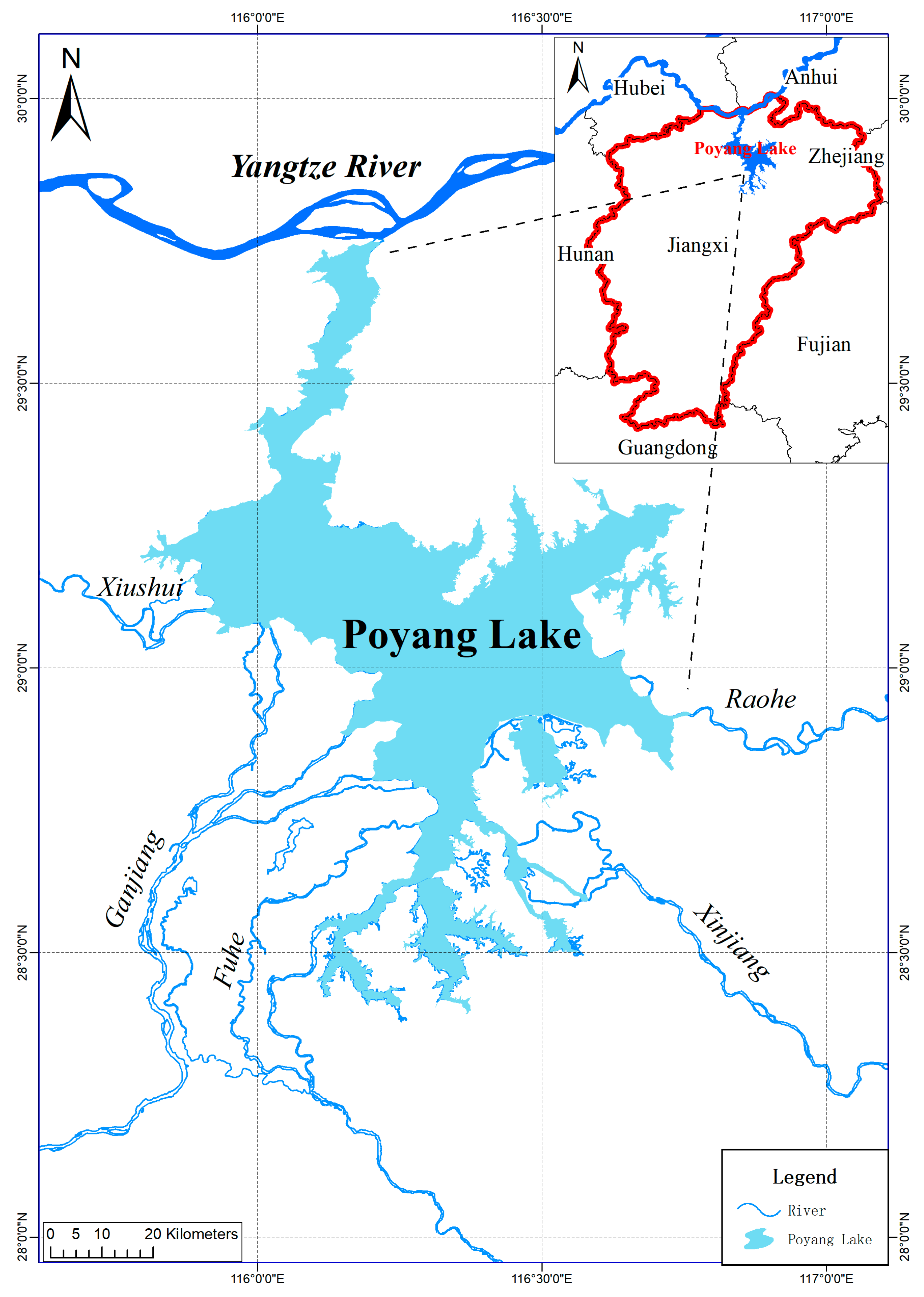
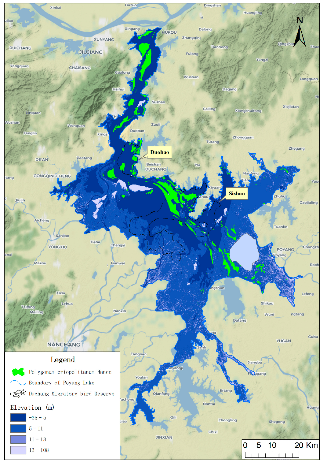
2.1. Polygonum Criopolitanum Distribution

Throughout the whole course of the investigation, we used the field direct observation method and data collection method to investigate, and the field direct observation method is the survey method that uses a sample line combined with sample quadrats along the line. Over the entire lake, the distribution and area of Polygonum criopolitanum patches at 9–11 m elevation were investigated, from October to December 2018. There are 182 Polygonum criopolitanum patches distributed in Poyang Lake, with a total area of 200.37 km2. In each patch, a survey transect was arranged from high to low along the elevation gradient. Three parallel 1 × 1 m quadrats were established every 50 m along each transect.
Wetland soil column samples were collected in the Polygonum criopolitanum distribution area in Poyang Lake wetland from 13–15 September 2019. Four 1 m × 1 m quadrats were established along the 9–12 m elevation belt, and the collection depth was 15 cm. Three cores were collected in each quadrat, and they were mixed evenly, placed in self-sealing bags, and transported back to the laboratory on the same day.

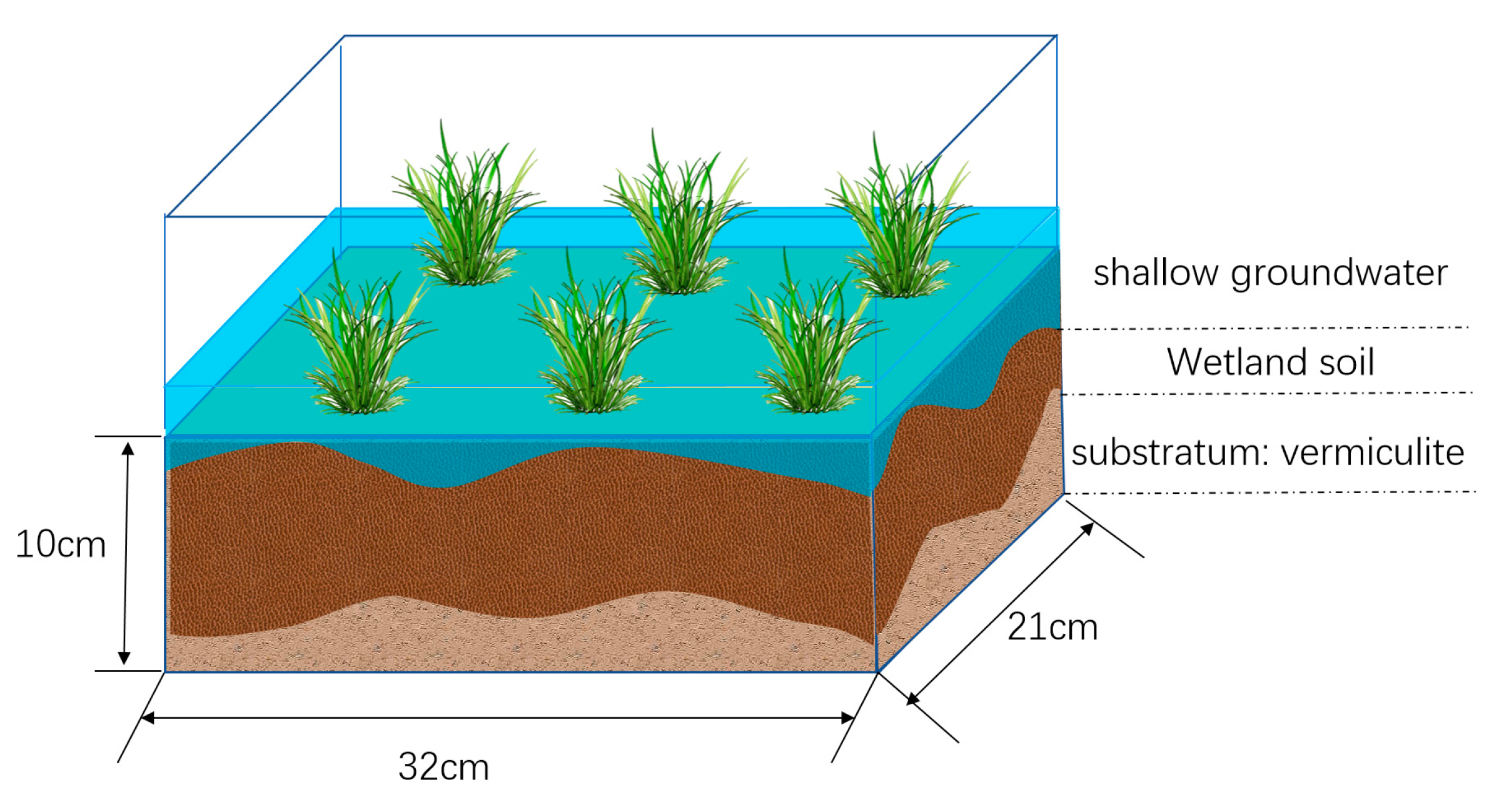
2.2. Controlled Growth Experiment Design

The germination experiment to simulate the growth process of Polygonum criopolitanum was conducted in the Nanchang University Botanical Garden, where meteorological conditions are essentially the same as in Poyang Lake. Before the start of the experiment, formed roots and buds in the four mixed samples were removed, and the samples were naturally air-dried and placed in four germination boxes (each 21 cm × 32 cm × 10 cm), in which a 1 cm layer of vermiculite was laid as substrate (Figure 3). The bottom of the germination box had a hole for draining water.
Before the beginning of the experiment, four germination boxes were labeled A–D, and used to simulate Polygonum criopolitanum growth at 12 m, 11 m, 10 m, and 9 m elevations, respectively. The surface layer of each germination box was submerged 1 to 2 cm; the water used in the experiment came from Poyang Lake and then accumulated water on the surface layer drained through the drainage holes on October 3, 11, 19 and 27, respectively (Table 1). This actual exposure time simulated beach land exposed at elevations of 12 to 9 m of the Poyang Lake wetland.
During the experiment, Polygonum criopolitanum aerial parts in the germination box were collected every 5 days, and 5 plants were collected each time. After the surface soil was removed, they were placed in the oven and dried continuously at 80 °C for 48 h to constant weight. After removal from the oven, dry biomass (g) was weighed with an electronic balance, and biomass mean and standard deviations (Mean ± S.D.) were calculated. To facilitate the analysis, Polygonum criopolitanum biomass per plant in the germination box was converted into biomass per unit area (g/m2). Seedlings of other plants that germinated during the growth process were removed immediately to avoid interspecific competition interference on the test results.

2.3. Growth Process Simulation

At present, the commonly used mathematical models to describe the crop growth process mainly include Logistic, Richards, Gompertz, etc. Previous studies on crop growth characteristics based on various mathematical models have become mature. In this article, Polygonum criopolitanum population growth was simulated by using the classical population ecology model-Logistic Equation [18], whose basic expression and general solution are as follows:
dy dt = ky ( 1 y a ) ,   y t = 0 = y 0
The general solution of the equation is:
y = a 1 + b × e kt
In the above formula, y is the population biomass (g/m2, dry weight); k is the intrinsic growth rate of the population, which represents the average growth rate of the population during the whole growth process (g/m2·d); a is the maximum population biomass (g/m2) that can be carried under certain resource conditions; and b is the regression coefficient. R2 is defined as the coefficient of determination in statistics, and the p value is the probability of the occurrence of samples or observations under the condition of null hypothesis. Both R2 and p value are common statistic terms and were obtained through the software Origin 2019.
The ecological significance of Logistic equation is that the population growth rate usually has the overall characteristics of “slow growth-fast growth-slow growth” in the whole growth period, representing the three stages of population germination, growth, and maturity (Figure 4). Its initial biomass is small, and increases gradually with time, and finally stabilizes in a numerical interval; the growth rate tends to zero at this time.
The growth characteristic curve shows an “S” shape, and the inflection point of the curve is at y = a/2, at which the growth rate is the fastest, and the speed is ka/4, the corresponding time t2. The growth rate begins to slow down and gradually accumulates to the maximum biomass when t > t2; that is, after the growth process crosses the inflection point, and then basically stagnates.
According to the curve characteristics, the effective growth time is defined as the time period from the growth initiation time to the growth arrest time (t0 − t3). When y = a/2, the growth rate of biomass is the fastest. When y = a/2, namely, dy dt | y = a 2 = ka 4 , at this time, the corresponding growth time is t2, which is the inflection point of the whole growth process.

3. Results

3.1. Polygonum Criopolitanum Spatial Distribution Pattern

Polygonum criopolitanum is distributed in belts and patches in the northern lake area and on the beach land of the east side of the river channel, with a total area of nearly 200 km2, accounting for 12% of the total vegetation area of Poyang Lake wetland (Figure 5). Moreover, it is mainly distributed in the 9–12 m elevation zone, accounting for 95% of its total area, of which the 10–11 m elevation zone is the most concentrated. In 2004, the Duchang Migratory Bird Reserve was established with the approval of the Jiangxi Provincial Government. Among them, Duobao district is located in the north, with an area of 57 km2 and an elevation of 9–10 m, and Sishan district is located in the south, with an area of about 354 km2 and an elevation of 10–11 m.

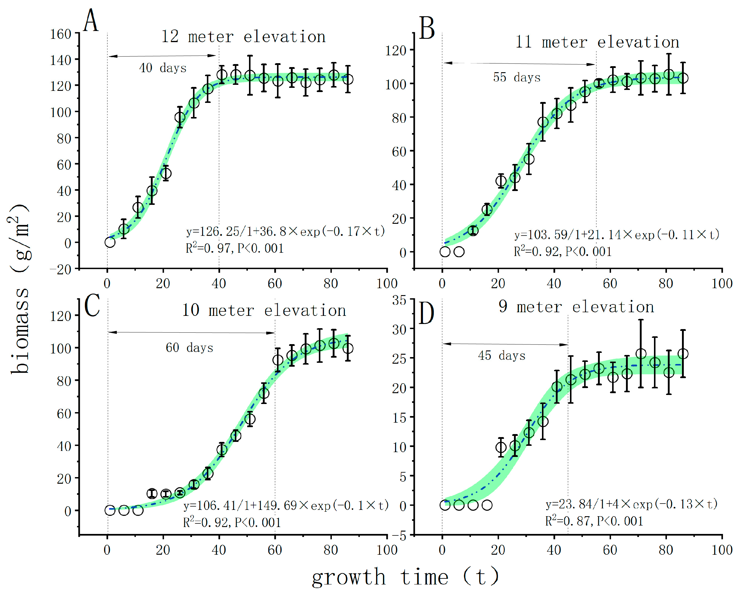
3.2. Simulation of Polygonum Criopolitanum Growth

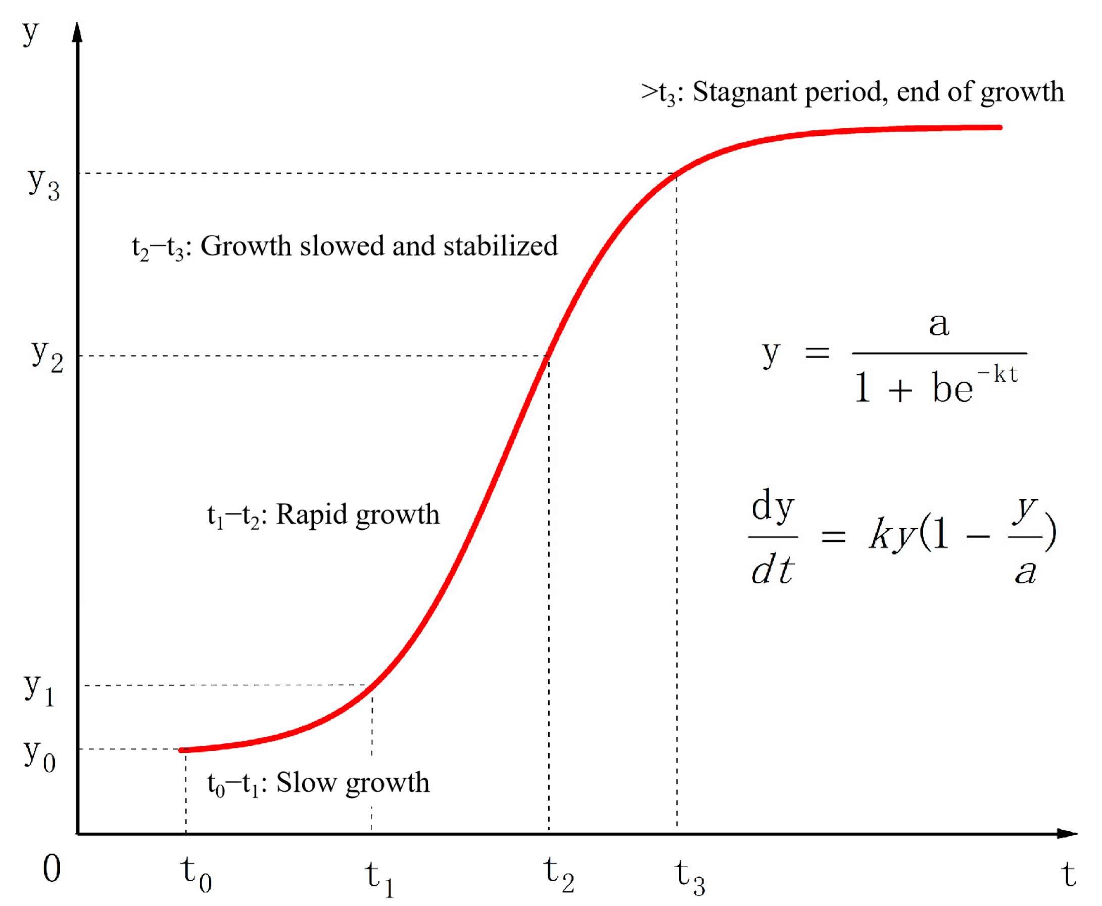
3.2.1. Polygonum Criopolitanum Growth Curve

Polygonum criopolitanum growth at 9–12 m elevation can be fitted by the Logistic curve, which has stage growth characteristics, but with significant differences in growth rate, inflection point time, and biomass accumulation. The accuracy of curve fitting can be determined by R2, R2 values of experimental results close to 1 (Figure 6 and Table 2). Over the entire growth period, average growth rate k was ranked from fast to slow in the order A > D > B > C; and maximum growth rate a × k 4 from fast to slow as A > B > C > D.
According to the experimental results, the logistic growth curve can be divided into four stages (Figure 4): slow growth (t0 − t1), rapid growth (t1 − t2), stable growth (t2 − t3), and growth stagnation (>t3).
According to the corresponding relationship between germination box number and beach land elevation, germination box A (representing the 12 m elevation zone) has the fastest growth rate, reaching the growth inflection point (biomass is 63.12 g/m2, maximum growth rate is 5.43 g/m2·d, Figure 6 and Table 2) in only 22 days, and then the biomass increases steadily and tends to stagnate. The growth inflexion of germination box C (representing the 10 m elevation zone), and germination box B (representing the 11 m elevation zone) appeared on the 31st and 46th day, respectively. The growth inflection point of germination box D (representing the 9 m elevation zone) also appeared on the 31st day, but its biomass accumulation rate was slow, the maximum biomass was less than 24 g/m2, and the fastest growth rate was only 0.77 g/m2·d. This is equivalent to 1/3 of the Polygonum criopolitanum growth rate at 10 and 11 m elevation, and less than 1/6 of its growth rate at 12 m elevation.

3.2.2. Polygonum Criopolitanum Effective Growth Time

The Logistic curve could clearly reflect Polygonum criopolitanum effective growth time in the four elevation zones. According to growth start and stagnation times of each elevation zone, effective growth time in the 9–12 m elevation zone was 40 days (from 23 October to 8 December), 55 days (from 13 October to 8 December), 55 days (18 October to 13 December) and 45 days (8 October to 23 November), respectively. After the effective growth time, Polygonum criopolitanum biomass changed little, and growth tended to stagnate (Figure 6).

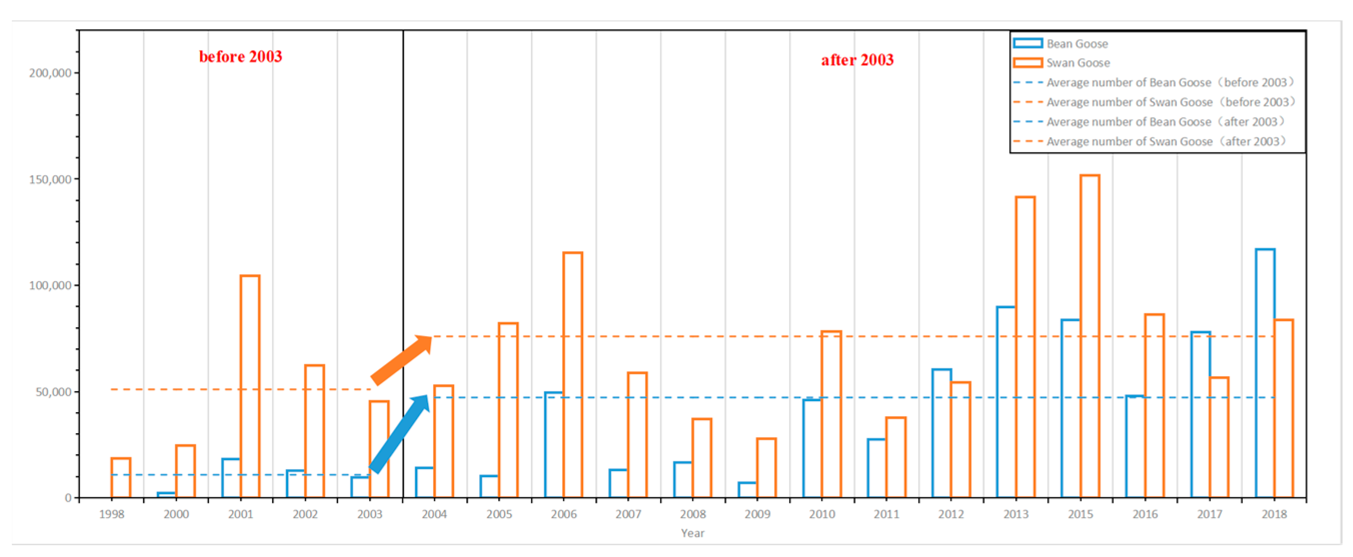
3.3. Polygonum Criopolitanum Expansion Effects on Overwintering Migratory Birds

The Polygonum criopolitanum distribution area in Poyang Lake wetland covers the Duobao (9–10 m elevation zone) and Sishan (10–11 m elevation zone) districts of the Duchang Migratory Bird Reserve. Before and after 2003, beach land exposure along the elevation gradient was quite different due to water level drawdown, which determines Polygonum criopolitanum primary production and biomass, and reserve habitat characteristics (Table 3).
In the 9–12 m elevation zone, the annual average water level from 1956 to 2002 was used to quantify beach land emergence processes before 2003, and the annual average water level from 2003 to 2018 was used to quantify it after 2003 (Table 3). Before 2003, beach land emergence in the 12 m elevation zone was on 27 October, corresponding to the emergence time of the 9 m elevation zone after 2003. Therefore, Polygonum criopolitanum growth rate and biomass accumulation in this elevation zone can be estimated by referring to the relevant parameters of the simulation curve (Figure 6D, Table 2) at 9 m elevation. Before 2003, for an average growth rate of 0.13 g/m2·d and 40 days effective growth time, Polygonum criopolitanum biomass accumulation at 12 m elevation was 5.2 g/m2, which was only equivalent to 4.1% of its biomass at the same elevation after 2003. For annual average water levels from 1956 to 2002, emergence times at 11 m, 10 m, and 9 m elevation were 7 November, 19 November, and 30 November, respectively. The effective growth time in the three elevation zones was 23 days, 11 days, and 0 days, respectively, when the temperature dropped to 10° until 30 November. When average growth rate was 0.13 g/m2·d, biomass accumulation was only 1.43 g and 2.99 g, respectively.
According to Anseriforme species and quantity statistics for Poyang Lake [19], Bean and Swan Goose numbers continuously increased from 1998 to 2018.
For example, the average numbers of Bean Geese in 1998–2018, 1998–2003, and 2004–2018 were 39,135, 10,836, and 47,220, respectively, while for Swan Geese they were 69,395, 51,022 and 75,957, respectively. Moreover, average survey results of Duchang Migratory Bird Reserve for many years also showed that the highest population densities were also for Swan and Bean Goose, which reached 367/km2 and 211/km2, respectively. Apparently, the numbers of these two wintering migratory bird species have increased significantly since 2003, with average increases of 48.9% and 335.8%, respectively, while the highest number of Swan Geese reached 151,580 (Figure 7).
Since the beginning of the new century, Poyang Lake has experienced significant changes of hydrological drought in autumn and winter. The dry season has shown a trend of advancing and prolonging. The low dry water level in the same period of history has repeatedly hit new lows. These changes have a direct impact on the wetland’s hydrological characteristics such as the outcropping time, the flooding duration, and the flooding depth of the wetland beach in Poyang Lake. It poses a significant threat to the ecological security of Poyang Lake Wetland and has attracted much attention. Under the river–lake relationship changes after 2003, the 9–12 m elevation beach land has formed a vast grassland, and since Polygonum criopolitanum is the main food source and ideal habitat for these two migratory birds [20,21], their populations have gradually increased.

4. Discussion

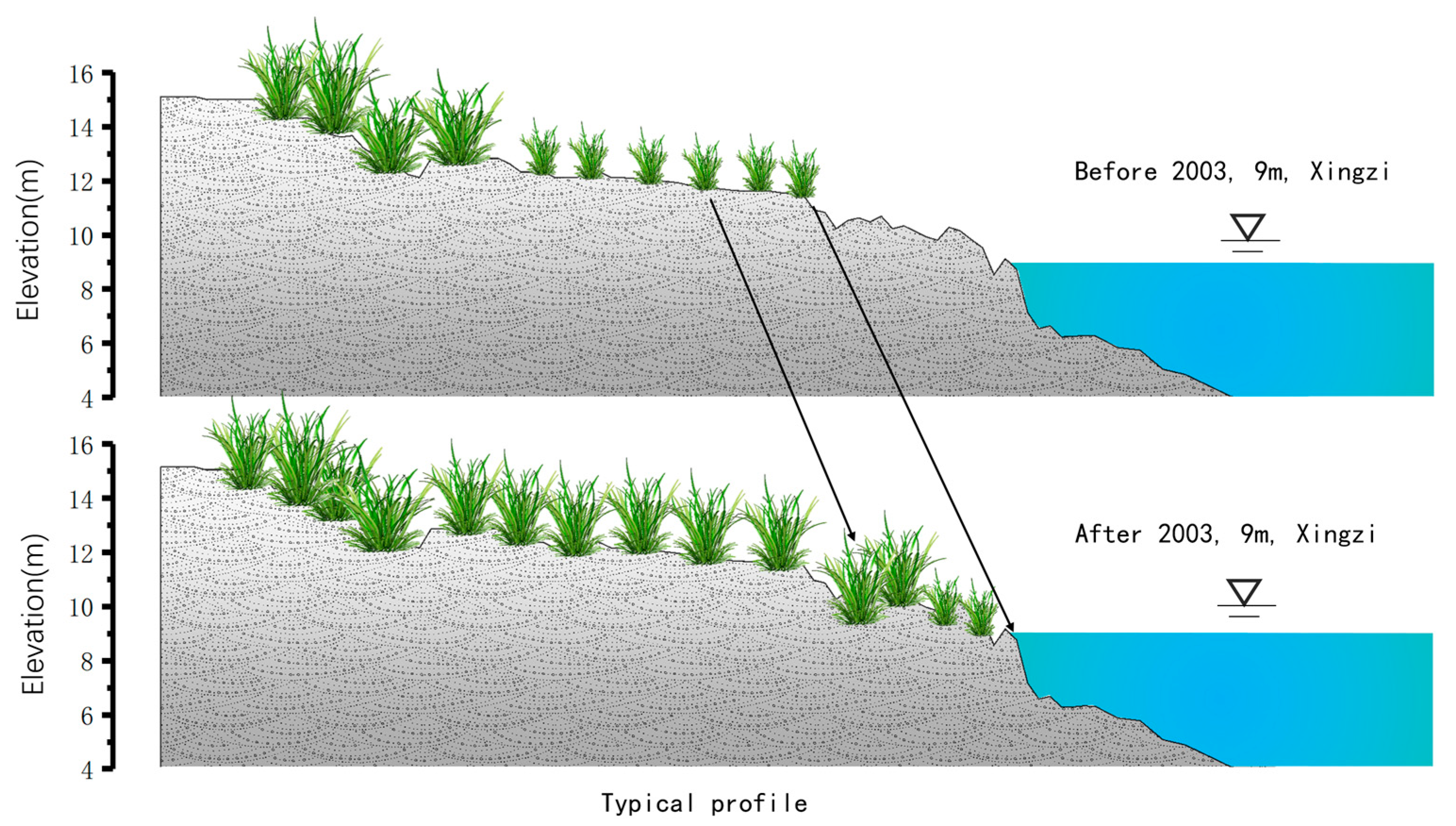
4.1. The Effects of River-Lake Relationships on the Expansion of Polygonum Criopolitanum

Poyang Lake, the research area of this paper, is a lake with obvious annual changes in wet and dry seasons. As far as vegetation is concerned, the impact of annual hydrological processes is significantly greater than that of interannual hydrological processes. The exposure time of Polygonum criopolitanum in the 11 m elevation beach land after 2003 was 11 October, 28 days earlier than before 2003, and exposure temperature was 22.1° , nearly 5° higher than before 2003. The lower limit of temperature for wetland vegetation and crop growth in the Poyang Lake Basin is 8–10° [22]. However, the lower temperature limit for Polygonum criopolitanum and Carex spp. growth is about 10° [23], and so when the temperature is above this lower limit, the vegetation can grow effectively. Additionally, the longer the duration is, and the greater the temperature range is above the lower limit, the more effective biological accumulated temperature (the sum of daily average temperature in the growth period) obtained by plants in the growth period, which is more beneficial for biomass accumulation. Therefore, earlier exposure of beach land means longer effective growth time and greater biomass accumulation. Similarly, after 2003 the rapid water recession in autumn also led to transformation of the 9 m high beach land from a previous “barren” mudflat into a Polygonum criopolitanum-covered area. Before 2003, the exposure time of this area was 30 November, when the temperature was as low as 10.8°, which could not meet the requirements for vegetation growth [24]. However, after 2003, the time of beach land exposure in this area was advanced to 27 October, when the temperature was about 17.7° (and a further 35 days before the temperature dropped to 10°), which provided sufficient time for Polygonum criopolitanum growth and expansion in this elevation zone.

4.2. The Relation between Polygonum Criopolitanum Expansion and Overwintering Geese

The Duchang Provincial Migratory Bird Reserve was established in 2004, which coincided with the significant changes in the relationship between rivers and lakes and the early recession of Poyang Lake in autumn. According to the overall planning of the nature reserve approved by the Jiangxi Provincial Government, its total area is 411 km2, with >90% in the 10–11 m elevation beach land category. At the same time, Polygonum criopolitanum growth at 10–11 m elevation is very consistent with the migration rhythm of overwintering geese. According to the Logistic simulation curve, the fastest growth rate (curve inflection point) and the maximum biomass half value (a/2) of Polygonum criopolitanum at 10–11 m elevation were on 3 November and 18 November, respectively, which corresponds to the rapid increase in overwintering geese numbers.
Conversely, Polygonum criopolitanum utilization value in the 12 m and 9 m elevation zones for geese is low [25]. For the 12 m elevation zone, Polygonum criopolitanum biomass increased by nearly 400% within 20 days after outcropping, but theoretical “slow” and “fast” growth periods were difficult to separate, and superimposed in practice. Maximum growth rate occurred on the 22nd day and the corresponding date was 23 October, when the geese had already arrived at Poyang Lake in small numbers. Maximum biomass occurred on 18 November, and during this period, the number of geese and food demand increased rapidly. However, at this time, the growth period was coming to an end and cellulose content was high, which did not meet the requirements of overwintering geese for “fresh green” food and easy digestion [23,26], Therefore, Polygonum criopolitanum availability at that elevation was restricted. The simulated growth curve of the 9 m elevation zone is relatively flat, and the goodness of fit is low (Figure 6D), and so both the “slow” and the “fast” growth periods have obvious biomass accumulation processes, but their levels are significantly lower than those of the growth curves of other elevation zones. The field investigation also showed that plants were short and communities were sparse at 9 m elevation. According to the annual average hydro-meteorological data after 2003, the outcrop time of this elevation section is 27 October, when the temperature has dropped to 15°. The time for the temperature to drop to the lower limit for growth (10°) is only about one month, making effective growth time too short, and the average temperature in the whole growth period was lower than 10°, which inhibited biomass accumulation [27,28,29].

4.3. The Implications for Wetlands Protection

Changes in river—lake relationships after 2003 resulted in the formation of meadows dominated by Cynodon dactylon and Hemarthria compressa on beach land >15 m elevation. Concurrently, a vast grassland formed on beach land of 9–12 m elevation. It created suitable habitat conditions and abundant food resources for overwintering migratory bird populations of Bean, White-fronted, Swan, and Grey Geese. For river-communicating lakes, water level fluctuation processes in autumn shapes the habitat pattern, and then affects the foraging of migratory birds. If beach land is exposed too early or too late, it may have adverse effects on geese overwintering.
Studies on the foraging characteristics of overwintering geese in Shengjin, Caizi, and Dongting Lakes in the middle and lower reaches of the Yangtze River show that Bean, Swan, and White-fronted Geese mainly feed on low and sparse wet vegetation with a height of 120–220 mm and a coverage of <50% [26]. Due to the higher temperature at the time of exposure, both plant height and population density of the wetland grassland formed by rapid receding water restricted geese foraging efficiency, although they have larger biomass [24]. Conversely, if emergence is delayed, the temperature is low when the beach land is exposed, and the effective growth time of wet vegetation is too short for primary production and subsequent geese foraging [29].
Based on erosion and deposition predictions for the Yangtze River mainstream, erosion will further intensify in the future [30,31], which also means that the Poyang Lake dry season will arrive earlier, beach land flooding time at each elevation will be further shortened, and the dominant vegetation such as Polygonum criopolitanum, Carex spp., and Phalaris arundinacea may spread to lower elevations. In the longer term, the habitat structure and ecological function of the reserve will undergo significant changes, and protection objectives and corresponding management work will require adjustment.

5. Conclusions

In this article, field investigation, controlled experiments, and statistical modeling were used to simulate Polygonum criopolitanum growth at 9–12 m elevation. We established its growth curve and did some quantitative analysis of effective growth time, growth rate, and fast-slow turning point. Polygonum criopolitanum expansion at 9–11 m elevation created fine habitat conditions and rich food resources for populations of Soybean Goose, White Goose, Swan Goose, and Cygnet. In the future, more in situ observations of Polygonum criopolitanum growth is needed, and the Logistic growth curve could be improved to predict the succession of wetland vegetation community structure. Due to the limitation of experimental conditions, we only repeated the experiment once. Harvest method may affect the biomass value, but it will not affect the overall change trend. In the next step, the number of repetitions will be increased to ensure more accurate experiments.

Author Contributions

Conceptualization, S.W. and Z.H.; methodology, Z.H.; software, S.Z.; validation, J.W., X.M. and Y.T.; formal analysis, S.W. and X.M.; investigation, Z.H.; resources, J.W.; data curation, Y.T.; writing—original draft preparation, Z.H. and S.Z.; writing—review and editing, Z.H. and S.Z.; visualization, S.Z. and J.W.; project administration, X.L. and W.P.; funding acquisition, S.W. and Z.H. All authors have read and agreed to the published version of the manuscript.

Funding

This research was funded by the National Natural Science Foundation of China (No. 52009148), Open Research Fund of Guangxi Key Laboratory of Water Engineering Materials and Structures, Guangxi institute of water resources research (GXHRI-WEMS-2020–13), State Key Laboratory of Simulation and Regulation of Water Cycle in River Basin (WE1203B082022), and Open Foundation of Hebei Key Laboratory of Wetland Ecology and Conservation (hklk201914).

Data Availability Statement

Not applicable.

Acknowledgments

The authors thank the China Institute of Water Resources and Hydropower Research.

Conflicts of Interest

The authors declare no conflict of interest.

References

  1. Ji, W.T.; Ge, G.; Li, H.H. Poyang Lake-Topography, Hydrology and Vegetation; Science Press: Beijing, China, 2017; pp. 187–232. [Google Scholar]
  2. Li, Y.L.; Yao, J.; Zhao, G.Z.; Zhang, Q. Evidences of hydraulic relationships between groundwater and lake water across the large floodplain wetland of Poyang Lake, China. Water Supply. 2017, 18, 698–712. [Google Scholar] [CrossRef]
  3. Han, Z.; Wang, S.Y.; Liu, X.B.; Peng, W.Q.; Ge, G.; Huang, A.P. Ecological thresholds for the dominated wetland plants of Poyang Lake along the gradient of flooding duration. J. Hydraul. Eng. 2019, 50, 252–262. [Google Scholar]
  4. Hu, Z.P.; Ge, G.; Liu, C.L. Cause analysis and early warning for wetland vegetation degradation in Poyang Lake. Resour. Environ. Yangtze Basin 2015, 24, 381–386. [Google Scholar]
  5. Feng, L.; Hu, C.; Chen, X.; Tian, L.; Chen, L. Human induced turbidity changes in Poyang Lake between 2000 and 2010: Observations from MODIS. J. Geophys. Res. 2012, 117, C07006. [Google Scholar] [CrossRef]
  6. Almasi, A.; Dargahi, A.; Ahagh, M.; Janjani, H.; Mohammadi, M.; Tabandeh, L. Efficiency of a constructed wetland in controlling organic pollutants, nitrogen, and heavy metals from sewage. J. Chem. Pharm. Sci. 2016, 9, 2924–2928. [Google Scholar]
  7. Sharafi, K.; Pirsaheb, M.; Khosravi, T.; Dargahi, A.; Moradi, M.; Savadpour, M.T. Fluctuation of organic substances, solids, protozoan cysts, and parasite egg at different units of a wastewater integrated stabilization pond (full scale treatment plant): A case study, Iran. Desalination Water Treat. 2016, 57, 4913–4919. [Google Scholar] [CrossRef]
  8. Almasi, A.; Mahmoudi, M.; Mohammadi, M.; Dargahi, A.; Biglari, H. Optimizing biological treatment of petroleum industry wastewater in a facultative stabilization pond for simultaneous removal of carbon and phenol. Toxin Rev. 2021, 40, 189–197. [Google Scholar] [CrossRef]
  9. Wan, R.R.; Yang, G.S.; Wang, X.L.; Qin, N.X.; Dai, X. Progress of research on the relationship between the Yangtze River and its connected lakes in the middle reaches. Lake Sci. 2019, 31, 183–194. [Google Scholar]
  10. Liu, X.B.; Han, Z.; Wang, S.Y.; Peng, W.Q. A research thinking of Poyang Lake wetland from the perspective of Yangtze River protection. J. China Inst. Water Resour. Hydropower Res. 2021, 19, 201–209. [Google Scholar]
  11. Li, B.; Wan, R.R.; Yang, G.S. Investigating spatiotemporal dynamics of Poyang wetland for the recent century. Lake Sci. 2022, 34, 1018–1029. [Google Scholar]
  12. Guan, L.; Jia, Y.; Saintilan, N.; Wang, Y.; Liu, G.; Lei, G. Causality between abundance and diversity is weak for wintering migratory waterbirds. Freshw. Biol. 2016, 61, 206–218. [Google Scholar] [CrossRef]
  13. Guan, S.; Lang, Q.; Zhang, B. Aquatic vegetation of Poyang Lake. Acta Hydrobiol. Sin. 1987, 11, 9–21. [Google Scholar]
  14. Li, Y.; Zhong, Y.; Shao, R.; Yan, C.; Jin, J.; Shan, J.; Li, F.; Ji, W.; Bin, L.; Zhang, X.; et al. Modified hydrological regime from the Three Gorges Dam increases the risk of food shortages for wintering waterbirds in Poyang Lake. Glob. Ecol. Conserv. 2020, 24, e01286. [Google Scholar] [CrossRef]
  15. Sun, C.; König, H.; Uthes, S.; Chen, C.; Li, P.; Hemminger, K. Protection effect of overwintering water bird habitat and defining the conservation priority area in Poyang Lake wetland, China. Environ. Res. Lett. 2020, 15, 125013. [Google Scholar] [CrossRef]
  16. Wu, H.; Zheng, B. Wetland area identification and waterbird protection management in consideration of lake topography and water level change. Glob. Ecol. Conserv. 2020, 23, e01056. [Google Scholar] [CrossRef]
  17. Zhang, M.; Ni, L.; Xu, J.; He, L.; Fu, H.; Liu, Z. Annual Dynamics of the Wetland Plants Community in Poyang Lake in Response to Water-Level Variations. Res. Environ. Sci. 2013, 26, 1057–1063. [Google Scholar]
  18. Verhulst, P.F. Notice sur la loi que la population suit dans son accroissement. Corresp. Math. Et Phys. 1838, 10, 113–121. [Google Scholar]
  19. Tu, Y.; Yu, C.; Huang, X.; Shan, J.; Sun, Z.; Wang, Z. Distribution and Population of the Overwintering Anatidae Waterfowl in the Poyang Lake. Acta Agric. Univ. Jiangxiensis 2009, 31, 760–764+771. [Google Scholar]
  20. Guo, H.; Li, Q.; Hu, B.; Liu, Y. Influence of Hydro-junction Project on Migratory Birds Habitat in Natural Reserves of Poyang Lake. Environ. Sci. Technol. 2016, 39, 181–186. [Google Scholar]
  21. Zhang, N.; Li, Y.K.; Shan, J.H. Community structure, abundance and spatial distribution of water birds wintering in Poyang Lake wetland. Lake Sci. 2019, 31, 183–194. [Google Scholar]
  22. Li, X.; Zhang, Q.; Shao, M. Spatial and temporal variability of leaf area index in the Poyang Lake basin and its relationship with climate factors. Resour. Environ. Yangtze Basin 2012, 21, 296–301. [Google Scholar]
  23. Meng, Z.; Xia, S.; Yu, X.; Rao, D.; Jin, B. A study on the suitable time window of feeding vegetation fit for overwintering geese in Poyang Lake. Acta Ecol. Sin. 2018, 38, 7539–7548. [Google Scholar]
  24. Zhang, C.Q.; Yang, C. Simulation of growth dynamics of four plants in the typical steppe of Inner Mongolia in growing season. Acta Ecol. Sin. 2007, 27, 3618–3629. [Google Scholar]
  25. Yuan, F.; Luo, H.; Chen, Y.; Ge, S.; Liu, K. Study on fitting of early growth and development curve of Nanjiang Yellow Goat. Chin. J. Anim. Sci. 2012, 48, 15–18. [Google Scholar]
  26. Wang, X.; Fox, A.D.; Cong, P.; Cao, L. Food constraints explain the restricted distribution of wintering Lesser White-fronted Geese Anser erythropus in China. Ibis 2013, 155, 576–592. [Google Scholar] [CrossRef]
  27. Xing, J.; Li, X.; Ni, H. The effect of temperature on seed germination of Carex lasiocarpa. Territ. Nat. Resour. Study 2011, 3, 91. [Google Scholar]
  28. Zhi, Y.; Liu, W.; Shao, M.Q. Dynamic Study of Waterbird Diversity in the Kangshan and Duchang Reserves on Poyang Lake. J. Ecol. Rural. Environ. 2020, 36, 1149–1153. [Google Scholar]
  29. Zhang, P.; Zou, Y.; Xie, Y. Phenological mismatch caused by water regime change may explain the population variation of the vulnerable lesser white-fronted goose in east Dongting Lake, China. Ecol. Indic. 2021, 127, 107776. [Google Scholar] [CrossRef]
  30. Yao, S.; Lu, J. Evolution analysis and scouring-deposition prediction of middle and lower reaches of Yangtze River. Yangtze River 2013, 44, 22–28. [Google Scholar]
  31. Hu, Z.P.; Lin, Y. Analysis of Evolution Process and Driving Factors for Aquatic Vegetations of Poyang Lake in 30 Years. Resour. Environ. Yangtze Basin 2019, 28, 1947–1955. [Google Scholar]
Figure 1. Poyang Lake location map.
Water 14 03164 g001
Figure 2. Characteristics of vegetation spread on Poyang Lake Wetland beach land before and after 2003.
Water 14 03164 g002
Figure 3. Schematic diagram of the controlled growth experiment design.
Water 14 03164 g003
Figure 4. Schematic diagram of Logistic growth curve.
Water 14 03164 g004
Figure 5. Spatial distribution characteristics of Polygonum criopolitanum in Poyang Lake wetland.
Water 14 03164 g005
Figure 6. Polygonum criopolitanum Logistic regression population growth curves in different elevation zones (A) represents 12 meter elevation, (B) represents 11 meter elevation, (C) represents 10 meter elevation, (D) represents 9 meter elevation.
Water 14 03164 g006
Figure 7. Statistics of species and quantity of Anseriformes in Poyang Lake (The red and bule arrows represent the change trend of the average number of quantity of Anseriformes).
Water 14 03164 g007
Table 1. Treatments of the experimental design.
Germination Box No.Elevation (m)Drainage Date
A12 m3 October
B11 m11 October
C10 m9 October
D9 m27 October
Table 2. Logistic equation fitting parameters.
Parameter/Equation12 m Elevation11 m Elevation10 m Elevation9 m Elevation
a126.25103.59106.4123.84
b36.821.14149.6947.59
K(g/m2·d)0.170.110.10.13
Fitting equation y = 126.25 1 + 36.8   ×   exp ( 0.17   ×   t ) y = 103.59 1 + 21.14   ×   exp ( 0.11   ×   t ) y = 106.41 1 + 149.69   ×   exp ( 0.1   ×   t ) y = 23.84 1 + 47.59   ×   exp ( 0.13   ×   t )
R20.970.920.920.87
p<0.01<0.01<0.01<0.01
curve’s inflection point (y = a/2)63.1251.853.2111.92
Occurrence time of inflection point (t0)22d31d46d31d
Maximum   growth   rate   ( a × k 4 ) 5.432.822.780.77
Table 3. Comparison of Exposure Process of 9–12 m Beach Land around 2003.
Beach Land ElevationAfter 2003Temperature (°C)Before 2003Temperature (°C)
12 m3 October2227 October17.7
11 m11 October22.17 November17.7
10 m9 October20.319 November11.8
9 m27 October17.730 November10.8
Publisher’s Note: MDPI stays neutral with regard to jurisdictional claims in published maps and institutional affiliations.

