
Analysis of the Characteristics and Driving Forces of Changes in Lake Water Volume in Inland Arid Basins in China

1
Key Laboratory of Water Cycle and Related Land Surface Processes, Institute of Geographic Sciences and Natural Resources Research, CAS, Beijing 100101, China
2
University of Chinese Academy of Sciences, Beijing 100049, China
3
College of Surveying and Geo-Informatics, Shandong Jianzhu University, Jinan 250101, China
*
Author to whom correspondence should be addressed.
Water 2022, 14(19), 3141; https://doi.org/10.3390/w14193141
Submission received: 4 August 2022
/
Revised: 27 September 2022
/
Accepted: 3 October 2022
/
Published: 5 October 2022
(This article belongs to the Special Issue Mapping and Change Analysis of Water and Wetland)
Abstract
:Lakes are sensitive indicators of climatic change and are important resources for regional economic development. In recent years, there have been many studies related to the changes in lake area and lake volume. However, further studies are still required to understand the responses of lakes to climatic change and human activities. This paper utilizes lakes in the Qaidam Basin, an inland arid region of China, as the object of study and investigates the characteristics of variability in lake changes and its driving forces by combining multi-source remote sensing, model simulations and historical data. We first analyzed the spatiotemporal pattern of climatic change in the basin under the background of global warming. The response of lake water volume to climatic change and human activities is then discussed. Finally, the main factors that affect the change in lake water volume in different regions of the basin are delineated. The water volume of lakes in the Qaidam Basin increased by 3.81 km3 from 1990 to 2020. Particularly since the 21st century, the water volume of lakes has increased rapidly, and an increasingly abrupt change appeared around 2015. The increases in precipitation and vegetation area are the main and secondary factors that led to the increase in total lake water volume in the basin, respectively. However, the main influencing factors still vary in different regions. The impact of air temperature, evaporation, and changes in the cropland area on the change in lake water volume is generally not obvious. Human activities, such as the development of salt lakes and damming, have led to substantial changes in the spatial pattern of lakes in the middle of the basin and are associated with the replacement, genesis, and disappearance of Yiliping Lake, Yahu Lake and West Taijinar Lake, respectively. This study reveals the changing characteristics of climate and lake water volume in inland arid basins in China, which are highly important to understand the responses of lakes to climatic change and human activities, and provides a scientific basis for the rational development and utilization of lake resources in arid basins.
1. Introduction
Lakes are an important part of the earth’s hydrosphere and are a link that connects all spheres of the earth [1]. They play an important role in the surface water cycle [2]. In recent decades, China has been attaching great importance to the study of lake resources. Since the 1960s, China has conducted two national lake surveys and many local lake surveys [3,4,5,6,7]. This had led to the achievement of milestones of research progress [8,9]. These efforts have made important contributions to the construction and development of Chinese lake databases and provide valuable information to comprehensively understand the dynamic changes of Chinese lakes and their response to climatic change and human activities.
Lakes are sensitive indicators of climatic change [10,11]. As a sensitive area of climate change and a vulnerable ecosystem area, the dynamics of lakes on the Qinghai-Tibet Plateau has become an important indicator for studying global climate change. Existing studies show that lakes on the Qinghai-Tibet Plateau are undergoing rapid expansion and that an increase in precipitation is a major reason for the expansion of lakes, followed by the melting of glaciers and the degradation of frozen soil [12]. The Qaidam Basin is located northeast of the Qinghai-Tibet Plateau and is a typical arid inland basin in China. In contrast to other regions of the Qinghai-Tibet Plateau, this region has a dry climate and limited precipitation [13]. Since lakes are among the scarce surface water resources, they play an important role in regulating the climate of arid regions and maintaining local economic development [14]. Studies have shown that the air temperature in the Qaidam Basin changed by 0.53 °C/10a from 1961 to 2010 [15], which is much higher than the trend of changes in other parts of the Qinghai-Tibet Plateau. Thus, the Qaidam Basin has become a key area for the study of climatic change.
There are various types of lakes in the Qaidam Basin, and most of them are terminal, salt water, and salt lakes. The change in terminal lakes is the result of the water volume balance in the basin and is very sensitive to the climatic change in the basin and even the world [16]. Salt lakes are important economic resources in the basin. The unique salt lake industry in the basin is the result of the most densely populated area of salt lakes in the world [17]. Thus, the lakes in the basin are an important foundation for local economic development. However, the development of salt lakes is often accompanied by intensive human activities [18]. Unreasonable development could not only affect the sustainable use of resources but can also cause irreversible damage to the regional microclimate. In view of the dual characteristics of lakes as both ecological and economic resources in the basin, it is necessary to comprehensively study the changes of lakes in the basin and their responses to climatic change and human activities.
Existing studies have shown that lakes in the Qaidam Basin respond significantly to changes in climate and land cover and human activities. The climatic factors that affect the change in lakes are regional as well, and this has been shown by lake precipitation, air temperature, and evaporation [19]. Analyses of changes in the land cover have proven that changes in vegetation and the cropland area are also important factors that affect the changes in lakes in the basin [17]. Single factor correlations have been studied by singly exploring the relationship between each factor and lake change [17,19]. However, lake change is a comprehensive result of the influence of multiple factors. These studies cannot compare the contribution of various factors to lake change and are not conducive to forming an in-depth understanding of the driving forces in lake change. A multiple linear regression (MLR) method can evaluate the impact of different independent variables on dependent variables by establishing the relationship between dependent variables and multiple independent variables. Thus, these types of analyses are applicable to analyze the driving forces involved in lake changes. Currently, this method is widely applied in the fields of economics and sociology, but it is rarely considered in analyzing the driving forces of lake changes [20,21]. Human activities that impact changes in lakes in the basin include the exploitation of salt lakes and the construction of dams [18]. However, owing to the difficulty of quantifying human activities, it is problematic for current studies to directly analyze their correlation with lake changes. The lake area is currently the main dependent variable in the analysis of drivers of lake change, but due to differences in topography around the lakes, the lake area does not fully reflect the true variability of lake water [22]. In addition, current studies in the Qaidam Basin are primarily based on analyses of individual lake changes, and there is a lack of understanding of the lake changes on the whole basin scale [17]. Some studies have conducted analyses on the scale of the whole basin [18]. However, they still adopted the lake area as the indicator, and this approach cannot adequately analyze the differences in changes across subregions.
The objective of this study was to analyze the lake water volume changes and their driving forces in the Qaidam Basin by combining multi-source remote sensing, model simulations and data from historical sources. First, the spatiotemporal pattern of climatic change in the basin under the background of global warming was analyzed with lake water volume as the main indicator. Changes in the lake water volume in different regions of the basin in response to climate change and human activities are then comprehensively discussed. Finally, the MLR model was used to delineate the main factors that affect the change in lake water volume in different regions. This study reveals the characteristics of changes in the water volume and driving forces of the lakes in inland arid basins in China and is intended to provide a theoretical basis for managing climatic change and the rational utilization of lake resources in inland arid regions in China.
2. Materials and Methods
2.1. Overview of the Study Area
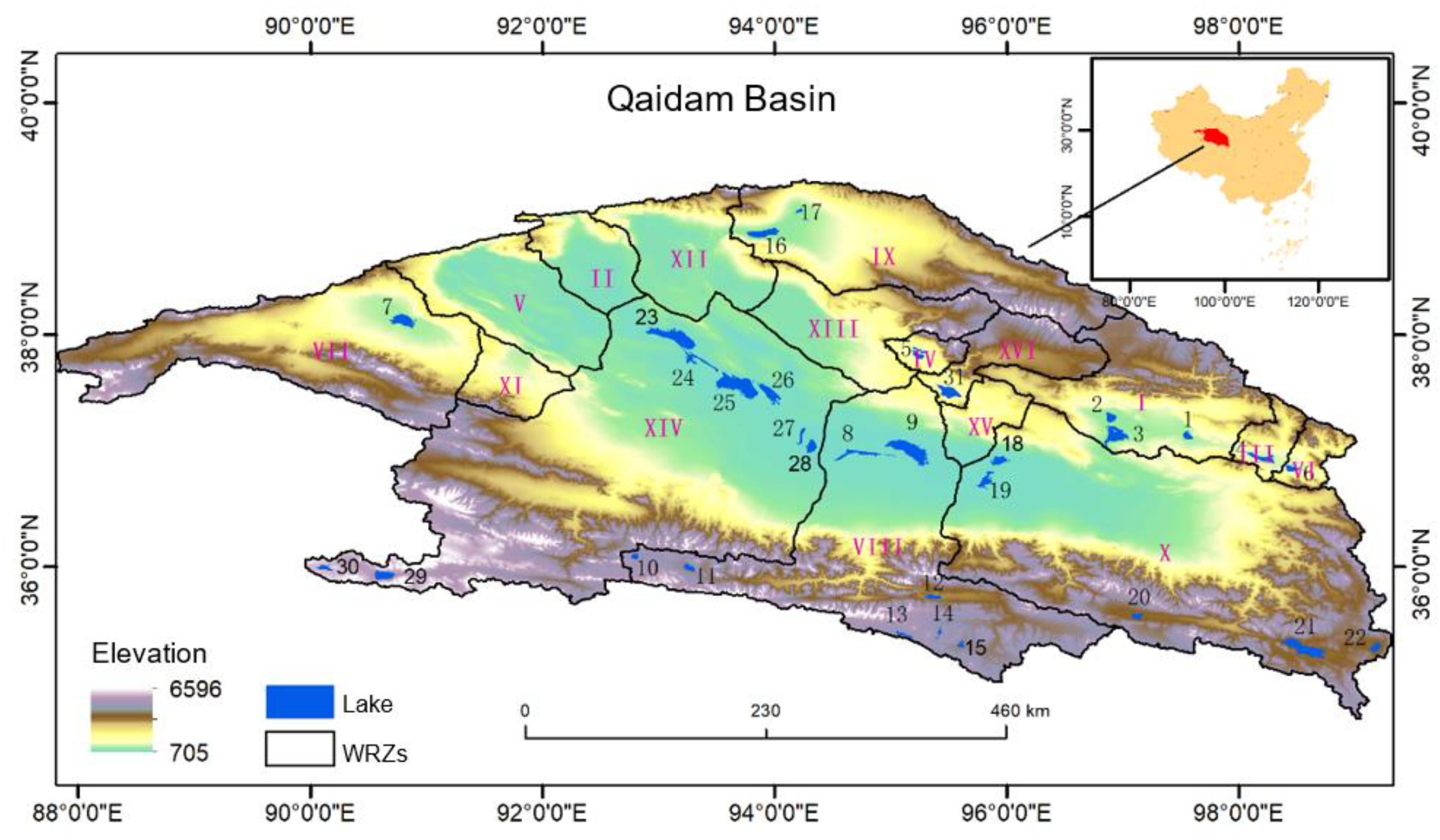
The Qaidam Basin (34°37′57”~39°18′42”, 90°27′56”~99°25′51”) is an enormous tectonic subsidence basin northeast of the Qinghai-Tibet Plateau that is approximately 800 km long from east to west and 300 km wide from north to south with a total area of 276,000 km2. The basin connects the Tibet Autonomous Region in the south, reaches Gansu Province in the north, borders the Xinjiang Uygur Autonomous Region in the west, and borders the Haibei and Hainan Tibetan Autonomous Prefectures of Qinghai Province in the east. It is the central hub among Qinghai, Gansu, Xinjiang, and Tibet. The basin is surrounded by high mountains, including the Kunlun Mountains in the south, the Qilian Mountains in the northeast, and the Altun Mountains and Qimantag Mountains in the northwest. The highest altitude in the basin is 6826 m, while the lowest is 2676~3200 m. As one of the most famous inland arid basins in the world, the Qaidam Basin has a dry climate and rare precipitation. Many lakes, salt lakes, and marshes are also characteristic of the Qaidam Basin. There are 31 lakes larger than 10 km2 in the basin, and most of them are terminal lakes in the center of the basin. These lakes only have water inflow and no water outflow. Moreover, owing to powerful evaporation, mineralization is very high, and most lakes are saltwater or saline. Alternatively, inflow-outflow lakes contain a large amount of freshwater resources and are primarily distributed in the mountainous areas with an altitude of more than 4000 m north of the Kunlun Mountains. Among them, the Donggi Conag Lake is the largest alternately inflow-outflow lake in the basin. According to the water resources zoning scheme of the first and second national comprehensive water resources assessment of China, the Qaidam Basin was divided into 16 level 4 water resources zones (WRZs), and we analyzed the spatial distribution of lakes by analyzing the area of lakes within different WRZs [23]. The names and ID of WRZ and lakes in the Qaidam are provided in Table 1.
2.2. Data
Three types of publicly available data were examined in this study, including lake storage variables, meteorological elements, and land cover (Table 2).
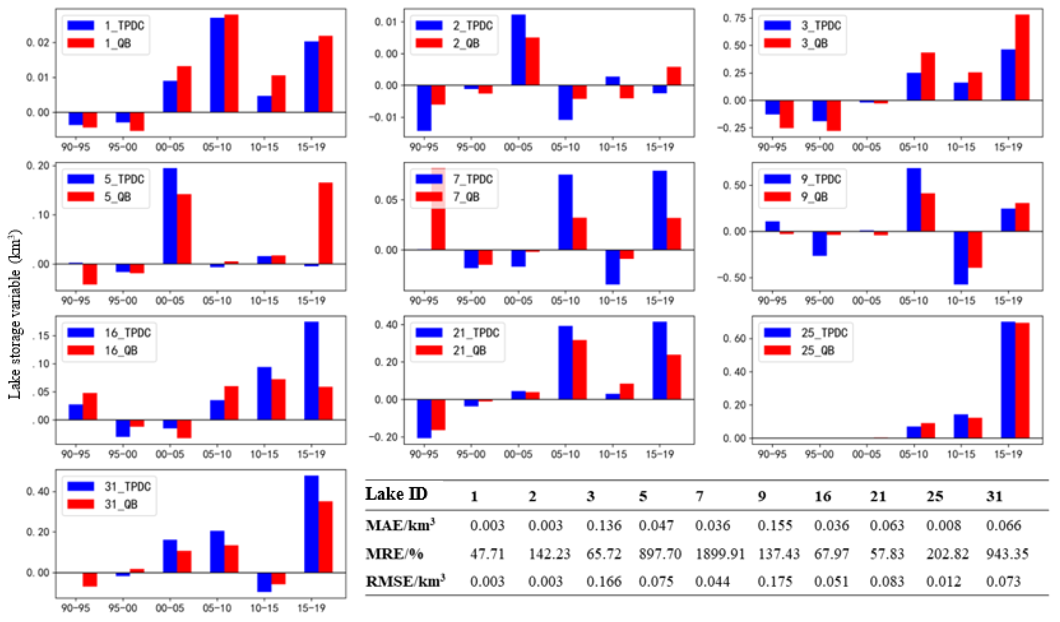
There are two types of data on lake storage variables that were used in this study. Among them, QB_LWSC (Qaidam Basin Lake Water Storage Change) is a lake storage variable that was estimated using multi-source remote sensing images and satellite altimetry data combined with a pyramid model (https://github.com/zhangch-ss/Monitoring_of_lake_dynamics, accessed on 13 May 2022) [24]. This dataset has a time span of 1990–2020, and a time resolution of 1a that is used to analyze changes in the time series and driving forces. TPDC_LWSC (Tibet Plateau Science Data Center Lake Water Storage Change) was released by the Qinghai-Tibet Plateau Science Data Center (https://data.tpdc.ac.cn/zh-hans/, accessed on 13 May 2022) and formulated using remote sensing images, Shuttle Radar Topography Mission (SRTM), and the pyramid model [25]. This dataset spans from 1990 to 2019 and has a time resolution of 5a. However, the small amount of data available is unsuitable for a correlation analysis. Therefore, it was primarily used to compare and verify the QB_LWSC in this study. The lakes used to compare and verify the TPDC_LWSC and QB_LWSC were lakes 1, 2, 3, 5, 7, 9, 16, 21, 25 and 31 (Figure 1).
Meteorological elements include precipitation, air temperature, and evaporation, which originated from MSWEP and GLDAS-Noah, respectively. MSWEP is a set of multi-source integrated precipitation products formed by integrating the advantages of stations, remote sensing, and reanalysis data (http://www.gloh2o.org/mswep/, accessed on 20 May 2022) with a spatial resolution of 0.1°. This data is well suited to evaluate the lakes in inland China and is highly applicable for areas that lack data [26]. GLDAS-Noah is the global land assimilation data generated using the Noah model based on satellite and ground observation data (https://disc.gsfc.nasa.gov/datasets, accessed on 20 May 2022) and has been proven to perform well in the arid regions of northwest China [27,28]. The evaporation and air temperature data provided in GLDAS-Noah were the only values used in this study. However, the V2 version only provides data since 2000, while the V1 version provides data from 1984 to 2014. Therefore, the two sets of data of the overlapping period (2000–2014) were subjected to deviation correction for this study, so that they met the analytical requirements for a long time series.
The land cover data was used to analyze the impact of vegetation and cropland on lake water volume. CLCD data is based on the Google Earth Engine Platform, which adopted the random forest method to classify the Landsat data to generate yearly land cover data of 30 m per year from 1985 to 2020 (https://zenodo.org/record/5210928#.YrREA3pBztV, accessed on 25 May 2022) [29]. This data has a long time series and has been widely verified in China. Its mapping accuracy is higher than that of MCD12Q1, GlobeLand30 and ESACCI_LC data of the same type.
2.3. Analysis of Change Trend
The Mann-Kendall (MK) test was adopted to analyze the trend of changes and the abrupt change characteristics of each element factor. This method is a nonparametric statistical test method, which does not rely on the characteristics of normal distribution and is insensitive to a few outliers. It has been widely used to analyze the trend of changes of meteorological and hydrological elements [30,31]. Assuming that the variables of a time series element are , the statistics can be defined as follows:
variance is as follows:
where is the number of groups of repeating elements in , and is the number of repeating elements in Group .
The test statistics are as follows:
During the test, the original hypothesis was set to no linear trend, and the alternative hypothesis was considered a linear trend. The two-sided test was adopted. Under the significance level of , was rejected, and was used in case of . Among them, if the conditions were met, indicates an increasing trend, while indicates a decreasing trend; .
The abrupt change point was further determined for the time series. An order column was built to count the cumulative number of in the time series:
Assuming that the time series were random and independent, the statistics were defined as follows:
where ; .
The time series was arranged in a reverse order, and the process above was repeated, which resulted in the following equation:
At the 0.05 significance level, the two curves and and two straight lines were drawn. > 0 and < 0 means increasing trend, on the contrary, a decreasing trend. The intersection (if any) between two straight lines and was the abrupt change point.
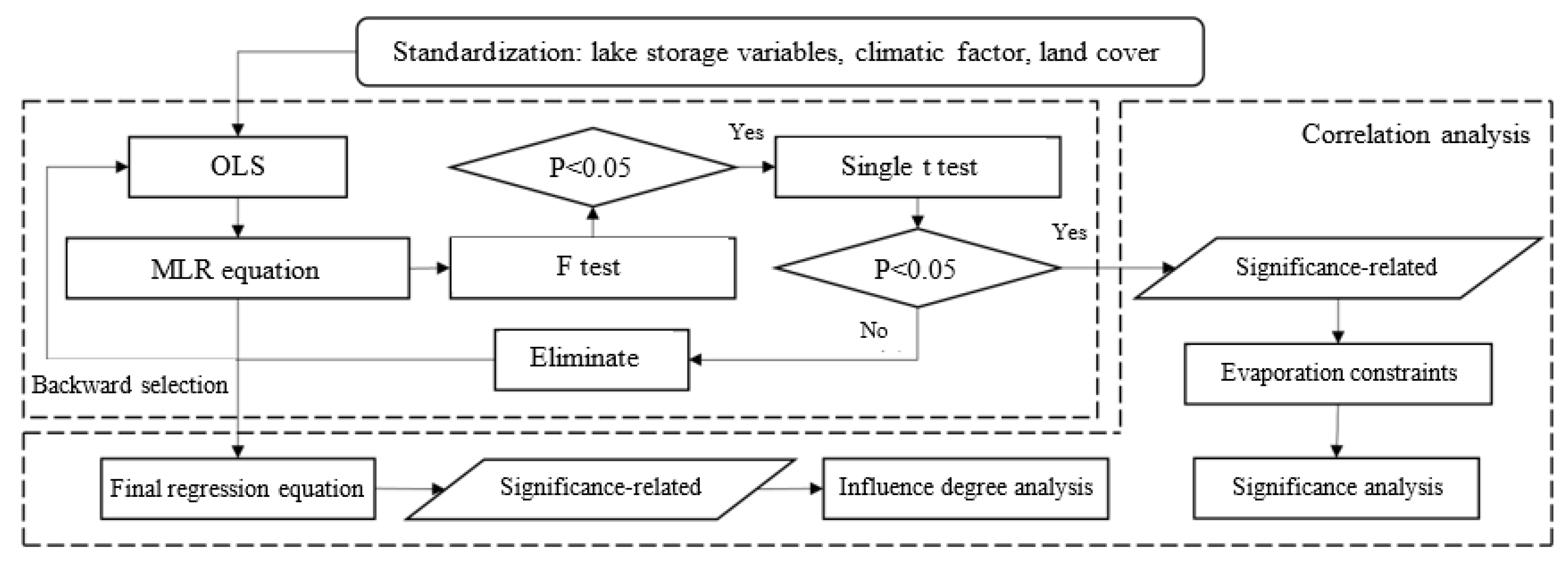
2.4. Correlation Analysis
The multiple linear regression (MLR) method was adopted to explore the correlation between lake water volume and multiple elements in this study as shown in Figure 2.
First, a linear regression model between lake storage variables and other elements () was constructed:
where is the regression constant, and was the regression coefficient.
The ordinary least square (OLS) method was adopted to estimate the parameters to minimize the square sum of the error between the estimated value and actual value of the lake storage variable:
To determine the minimum value of , the partial derivative of each element was set to 0 as shown in equation 1.6. The equation can be solved to complete the estimation of multiple linear regression constants and regression coefficients.
The F-test was then adopted to evaluate the overall significance of the multiple linear regression model to ensure the overall significance of the model, and a t-test was used to evaluate the significance of each element on the lake storage variables.
Finally, the backward selection method was adopted to eliminate the elements with significance <0.05. Moreover, previous research indicated that the negative correlation between evaporation and lake storage variable (if taken as the dependent variable) is explainable, namely, more lake water volume can be maintained owing to the reduction in evaporation. If there was a positive correlation, the increase in volume of lake water could lead to an increase in evaporation. Although this indicates the impact of lake expansion, the evaporation in a positive correlation cannot be used to characterize the contribution to lake water volume. Therefore, the evaporation elements, which do not meet the conditions, are eliminated in the backward selection method. In addition, the original elements are standardized in this study, and the coefficient of the final multiple linear regression model is the standardized coefficient Beta. It is possible to determine the contribution or influence of different elements on the lake storage variables by comparing the size of Beta.
3. Results and Discussion
3.1. Comparison and Verification of Lake Water Volume Change
Comparisons showed that the average mean absolute error (MAE) of the change of lake storage volume in TPDC_LWSC and QB_LWSC was between 0.003 km3 and 0.155 km3, and Tuosu Lake (2, 0.136) and Dabuxun Lake (9, 0.155) had higher MAE values (Figure 3). The maximum relative error (AE) is 0.316 km3, which appears in the comparison of storage variables in Tuosu Lake from 2015 to 2019. The average mean relative error (MRE) was higher and ranged from 47.71% to 1899.91%, primarily because of the difference between the two types of data at low values. For example, TPDC_LWSC and QB_LWSC show that the storage variables of Gasikule Lake (ID:7) were 0.00073 km3 and 0.081 km3 from 1990 to 1995, respectively, and the AE was −0.080 km3. However, the relative error (RE) was as high as 11,101.82%, which resulted in the increase in overall MRE. These values reflect the great uncertainty of both types of data in characterizing small lake storage variables. The root mean square error (RMSE) was between 0.003 km3 and 0.175 km3, and the characteristics of its distribution were similar to those of the MAE.
In summary, owing to the difference in data sources and the substantial time span (5a), the lake storage variables obtained from TPDC_LWSC and QB_LWSC have some differences, but almost all show a trend of “similar increase and decrease.” The most obvious relative error of TPDC_LWSC and QB_LWSC occurs at low values, and the AE at the low value is small. Thus, TPDC_LWSC and QB_LWSC are highly consistent. QB_LWSC has a higher time resolution and complete time series compared with TPDC_LWSC and is more suitable to analyze the characteristics of time series and perform a correlation analysis.
3.2. Spatiotemporal Change Characteristics of the Lake Water Volume
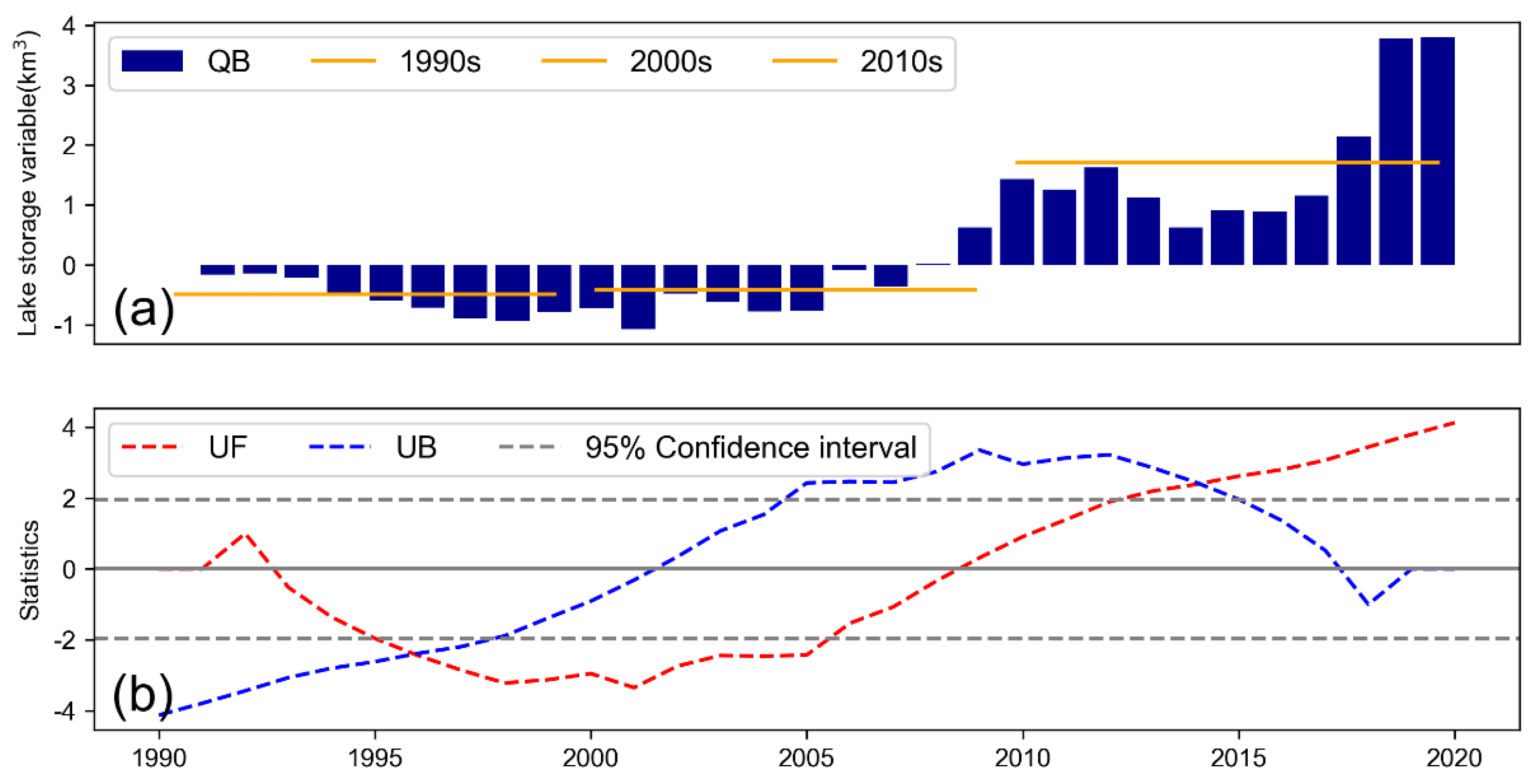
Table 3 and Figure 4 show the characteristics of changes in water volume in major lakes in the Qaidam Basin from 1990 to 2020 over a time series. The change and trend of change clearly show that the total water volume of major lakes in the basin increased by 3.81 km3 with a rate of increase of 0.79 km3/a, which presented a trend of a significant increase (QB, Z > 1.96, p < 0.1). A total of 73.33% of the lakes tended to significantly increase and contributed 4.22 km3 of the water volume (In Supplementary Materials Figure S1), which was 110.76% of the net increase. In contrast, the water volume of North Huobuxun Lake (ID 19, Z < −1.96, p > 0.1) and West Taijinar Lake (ID 24, Z < −1.96, p > 0.1) decreased by 0.17 km3 and 0.01 km3, respectively, which both tended to significantly decrease. However, the changes in Dabuxun Lake (ID 9, Z < 1.96, p >0.1) and East Taijinar Lake (ID 26, Z < 1.96, p >0.1) were substantial at 0.36 km3 and −0.21 km3, respectively, but the trends of their changes were not significant.
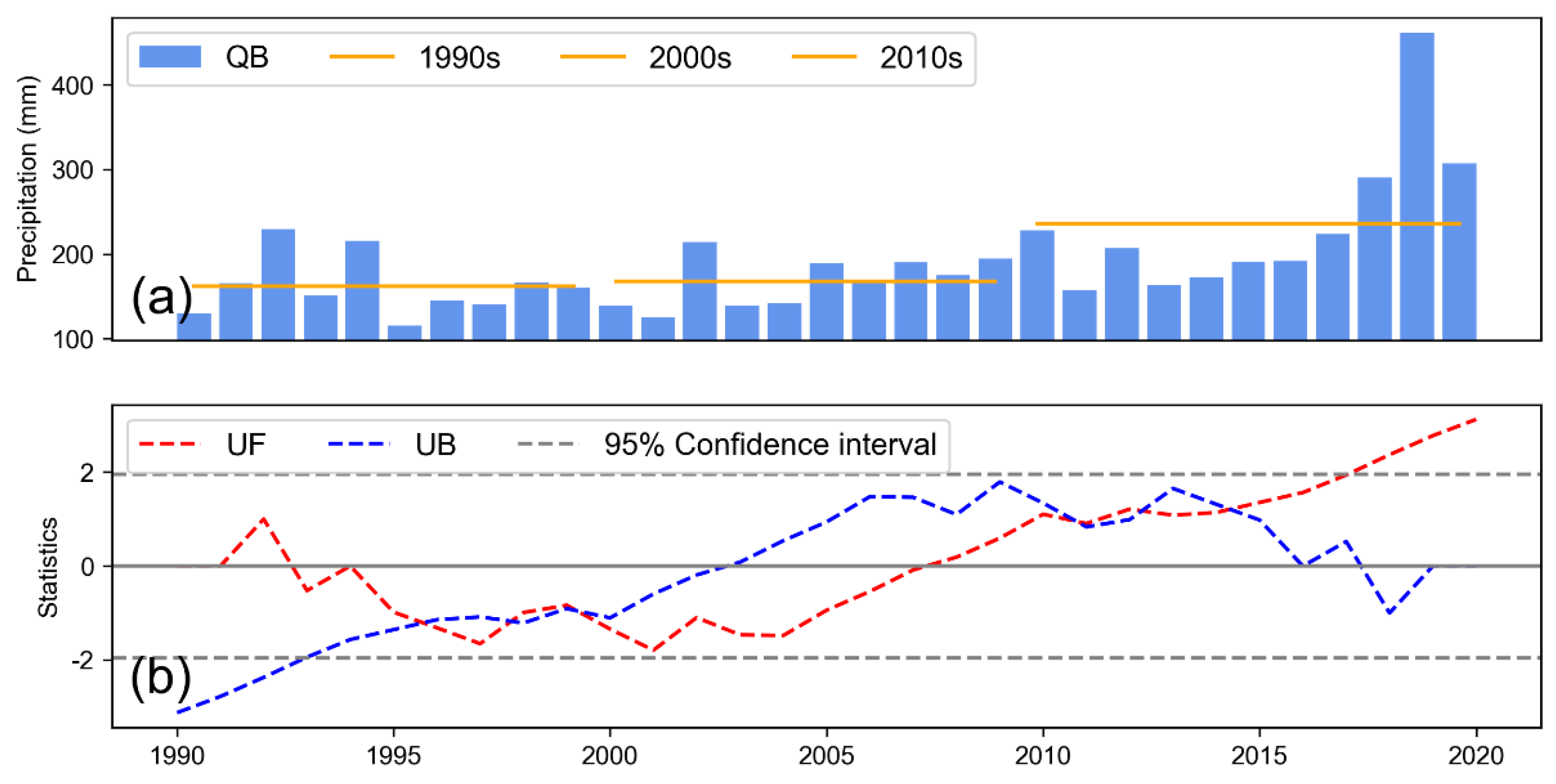
An analysis of the characteristics of changes in the time series showed that the total volume of lake water in the basin changed very slightly from 1990 to 2000, with a decrease of only 0.72 km3 and a rate of change of 0.07 km3/a. In contrast, since the 21st century, the volume of total lake water has increased by 4.53 km3, with a rate of change (0.23 km3/a) that was 3.29-fold of that between 1990 and 2000, and the increment and rates of change were very significant. The average changes in the volume of lake water in the 1990s, 2000s and 2010s were −0.26 km3, −0.71 km3, and 1.36 km3, respectively. It is readily apparent that the volume of total lake water in the basin has been steadily increasing since 2010.
It is apparent from the abrupt changes in the test results, that the total volume of lake water decreased and increased in 1996 and 2014, respectively, but it was not significant at the 0.05 significance level. In terms of specific lakes, some of the lakes abruptly changed points around 1995 and 2015. This was particularly true for Tuosu Lake, Keke Salt Lake and Dabuxun Lake.
In conclusion, the volume of water in the lakes primarily increased from 1990 to 2020 in the Qaidam Basin, and only a few lakes had a trend of changing insignificantly or significantly decreasing. The volume of water in most lakes decreased abruptly around 1995 but increased abruptly around 2015.
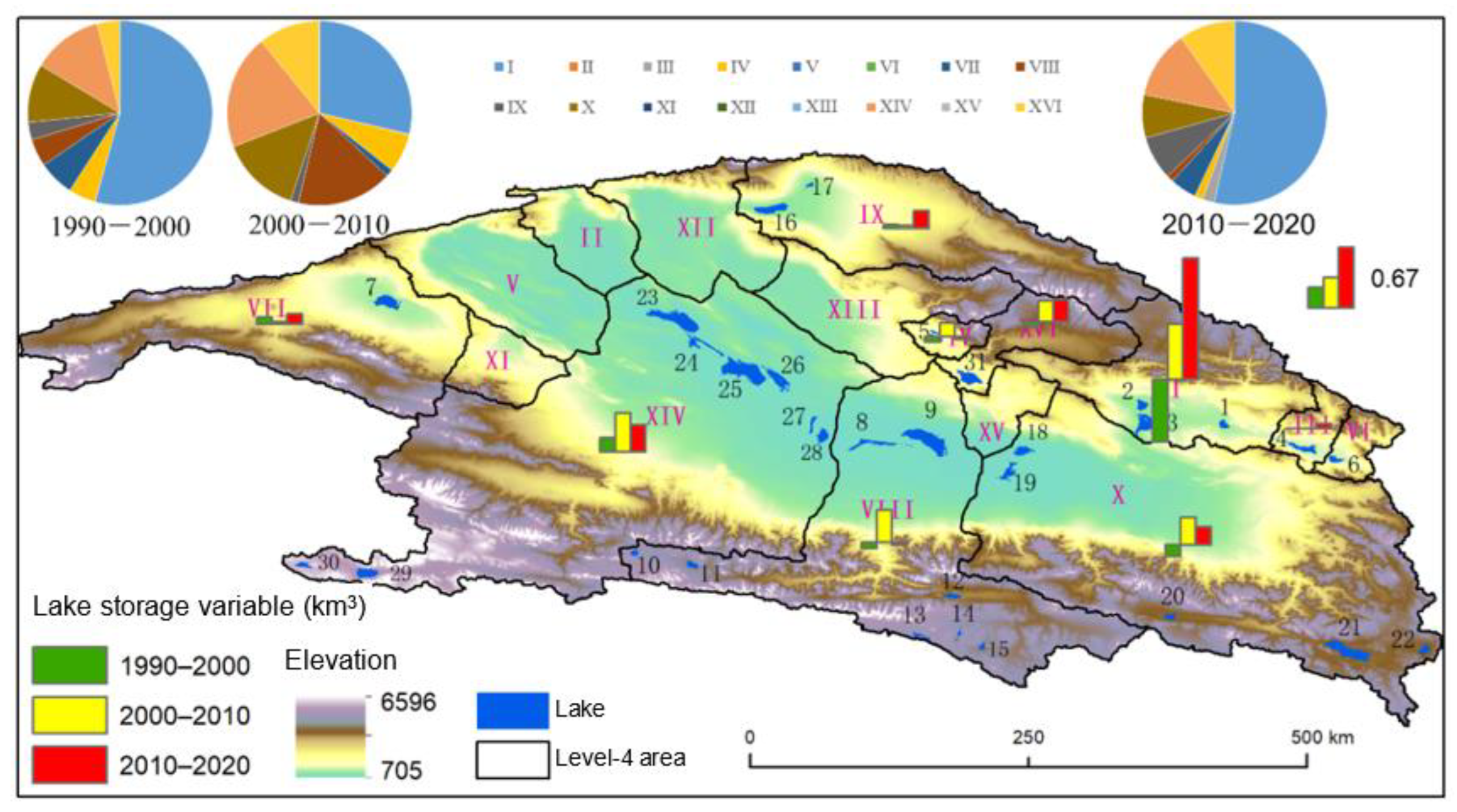
Large and medium-sized lakes are primarily distributed in the arid region in the middle of the Qaidam Basin, and small lakes are primarily distributed in the mountains around the basin (Figure 5). It is apparent from the perspective of spatial pattern in the change in volume of lake water that WRZ I (two lakes) northeast of the basin had the most dramatic change in lake water volume. In 1990–2000, 2000–2010 and 2010–2020, the total lake storage variables in WRZ I accounted for 54.36%, 28.69% and 53.54% of the total lake storage variables in the basin, respectively. The sum of lake storage variables in WRZ VIII, X and XIV (eight lakes) in the middle of the basin accounted for 27.4%, 50.84% and 20.79%, respectively. Thus, there were substantial differences in the changes of lake water volume in different regions of the basin.
3.3. Characteristics of Spatiotemporal Changes of Meteorological Elements
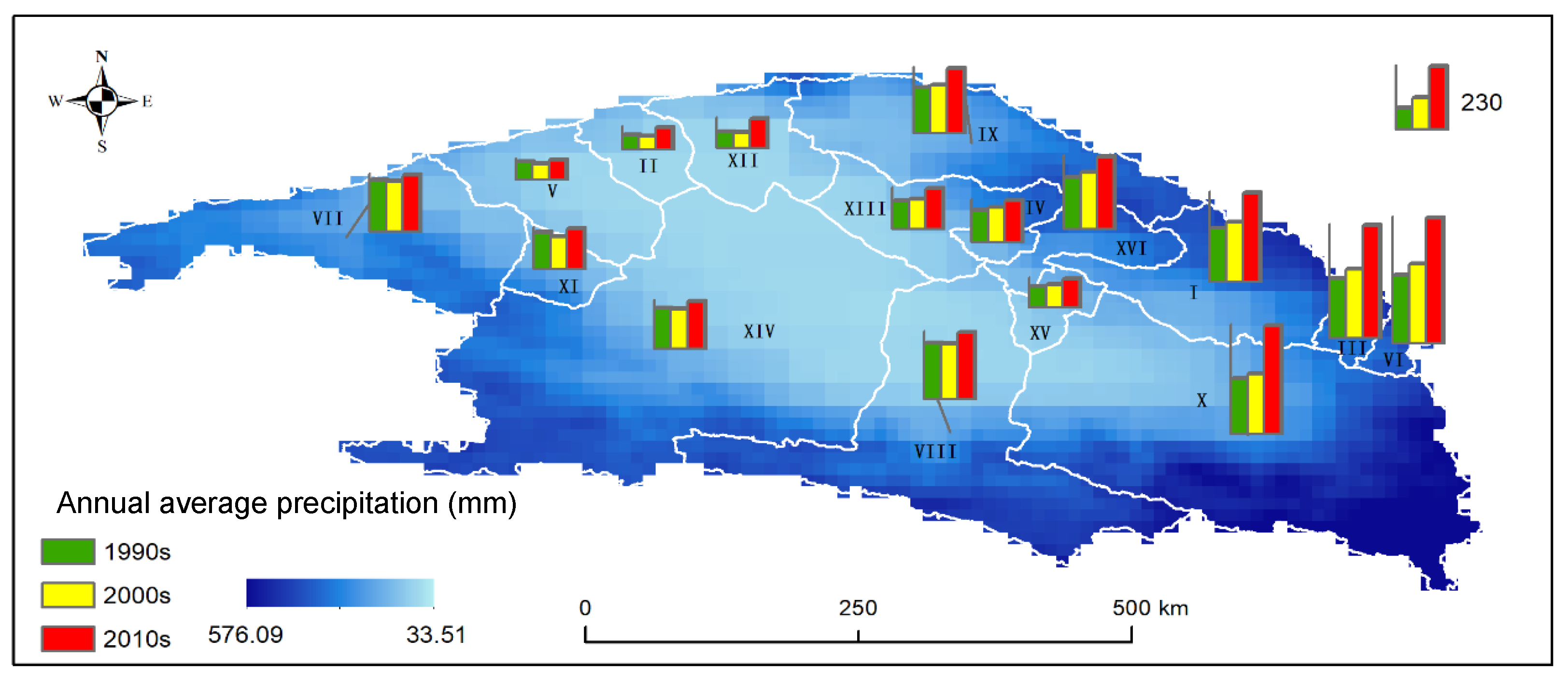
Table 4 and Figure 6 show the characteristics of change in precipitation in the basin from 1990 to 2020. The trend of change in precipitation clearly showed that the precipitation in the whole basin significantly increased from 1990 to 2020 (QB, z > 1.96, p < 0.1). Except for WRZ V and XII that tended to increase and WRZ VIII that lacked a significant trend, the other areas tended to significantly increase. The change in precipitation showed that the decades average precipitation of the basin was 162.08 mm in the 1990s. The change increased slightly to 167.47 mm in the 2000s. The decades average precipitation in the 2010s increased significantly to 235.83 mm, which was 1.46- and 1.41-fold of those during the previous two periods, respectively.
The abrupt test results of the changes (the area names correspond to the numbers of WRZ I-XVI from left to right and from top to bottom) showed that there was an abrupt change in the decrease in precipitation in the basin from 1995 to 2000, while an abrupt increasing change appeared from 2015 to 2020. These changes were consistent with the change in total lake water volume in the basin. Among all the WRZ (In Supplementary Materials Figure S2), except for WRZ III (Chaikai Lake-Keke Salt Lake Water System) and WRZ VI (Dulan Lake Water System), the precipitation in other areas abruptly changed to varying degrees, and all passed the significance test at the level of 0.05. Moreover, the abrupt increase in precipitation in different regions appeared after 2000, particularly in 2015. These results show that the predominant change in the precipitation in the Qaidam Basin was an increase. Particularly since the 21st century, the trend of increase in precipitation has been very significant in the basin.
The spatial pattern of precipitation indicated that the precipitation in the basin was characterized by more precipitation in the southeast, less in the northwest, more in the periphery, and less in the middle, which corresponds to the altitude characteristics of high elevation around the basin and low elevation in the middle (Figure 7). This is owing to the barrier action of the Qinghai-Tibet Plateau and the obstruction of the Hengduan Mountains to the warm and humid airflow of the southwest monsoons, which results in the formation of a unique spatial distribution pattern of precipitation in the Qaidam Basin.
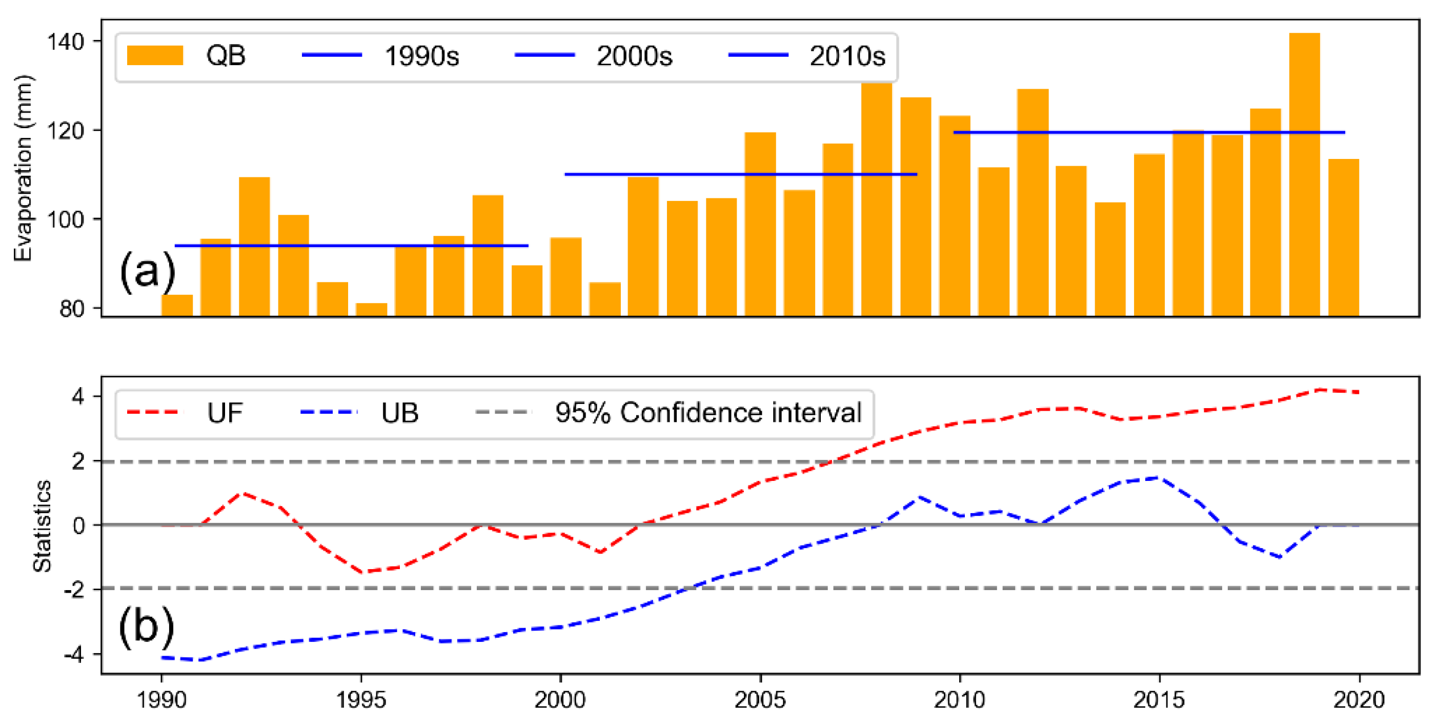
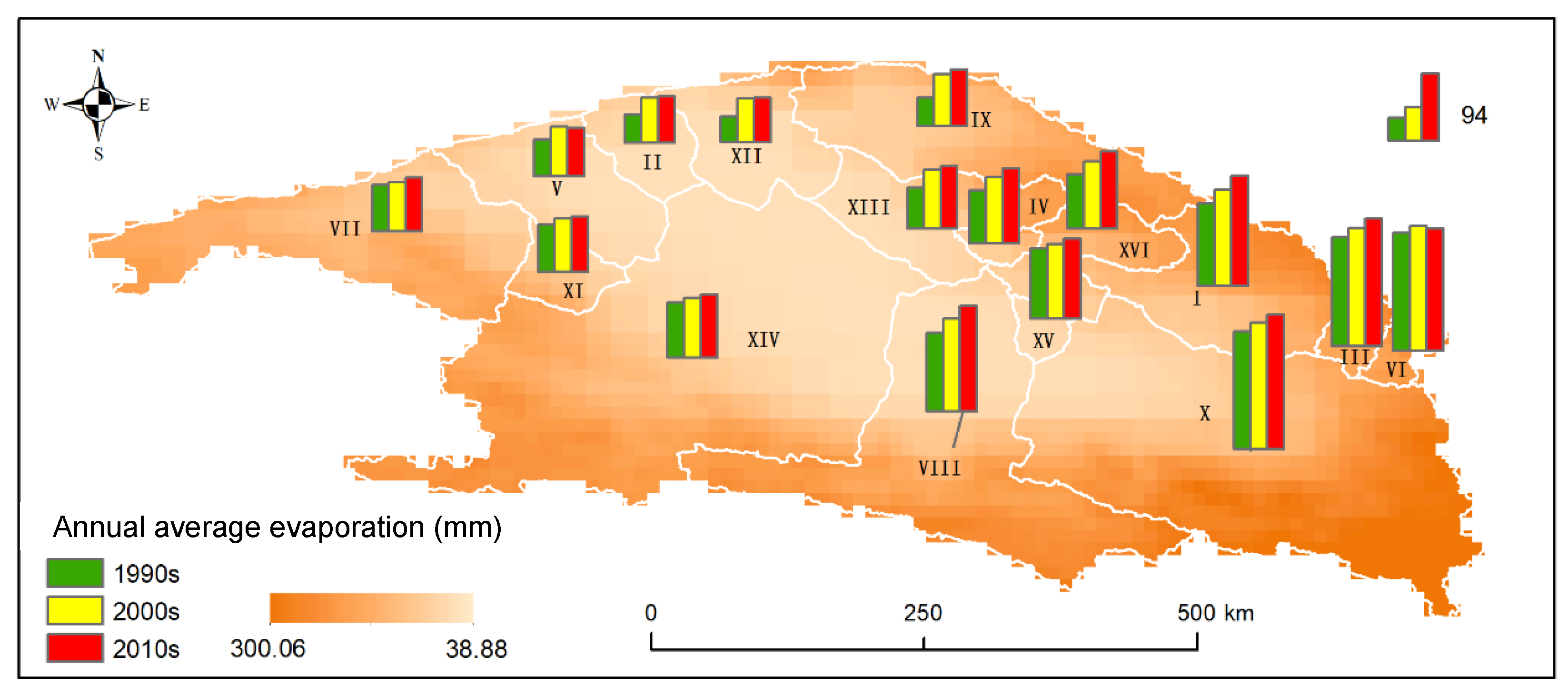
Table 5 and Figure 8 show the characteristics of changes over a time series of the actual evaporation in the basin from 1990 to 2020. The trend of changes in evaporation clearly showed that the actual evaporation of the basin increased significantly (QB, Z > 1.96, p < 0.1), and except for WRZ XIV (Nalinggele Wutumeiren Area), the other WRZ tended to significantly increase (In Supplementary Materials Figure S3). In terms of change, the annual averages of the actual evaporation of the basin in 1990s, 2000s and 2010s were 93.93 mm, 109.98 mm, and 119.35 mm, respectively, and the growth of the actual evaporation remained relatively stable for 30 years.
There was no abrupt change in the actual evaporation of the basin from 1990 to 2020. With the exceptions of WRZs VI (Dulan Lake Water System), XIV (Nalinggele Wutumeiren Area) and XV (Quanji River/Xiezuo Lake Water System), there was no abrupt change among the WRZs.An analysis of the spatial pattern (Figure 9) indicated that the spatial distribution of actual evaporation in the basin was consistent with precipitation, but it did not show the obvious characteristics of less in the middle and more in the periphery owing to the fact that the evaporation in the middle was more significant. The evaporation in the middle of basin was significantly greater than the precipitation (Figure 7 and Figure 9), indicating the remarkable characteristics of arid/semiarid regions.
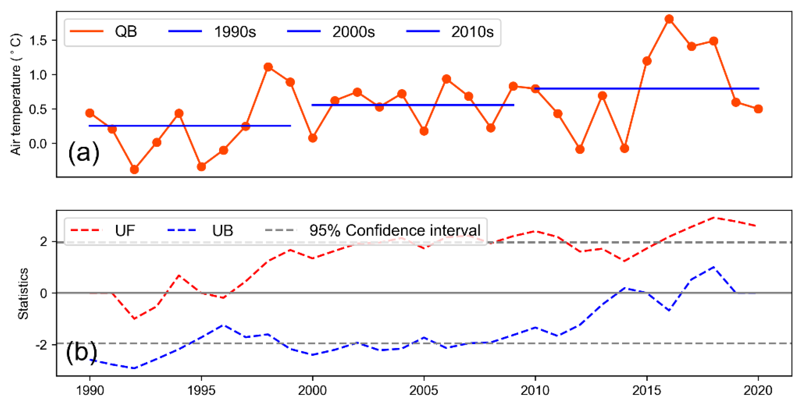
The air temperature in the basin did not change dramatically from 1990 to 2020 compared with the precipitation and actual evaporation. However, it still significantly trended upward (QB, Z > 1.96, p < 0.1) (Table 6). Except that the changes in air temperature in WRZ V, IX and XI were not significant, and there was a slight uptrend in WRZ X, the other areas tended to significantly increase (In Supplementary Materials Figure S4). The annual average air temperature in the 1990s, 2000s and 2010s changed by 0.25, 0.55 and 0.80 °C, respectively, with an increasing rate of 0.28 °C/10a. The whole basin and some areas obviously increased in 1995 and 2014.
The results of an abrupt change test indicated that there was no abrupt change in the air temperature of the basin, only a stable uptrend (Figure 10). However, the air temperature in WRZ II (Chahansilatu Dry Saline Area), WRZ V (Dalangtan-Fengnan Dry Salina Area), WRZ XI (Laomangya Lake Water System) and WRZ XIV (Nalinggele Wutumeiren Area) among each WRZ all abruptly changed and were significant at the 0.05 level (In Supplementary Materials Figure S4). The abrupt change was concentrated around 1995 and 2015 in which the air temperature of WRZ II and XIV decreased around 1995 and increased around 2015, while the air temperature of WRZs V and Xi reacted in the opposite manner.
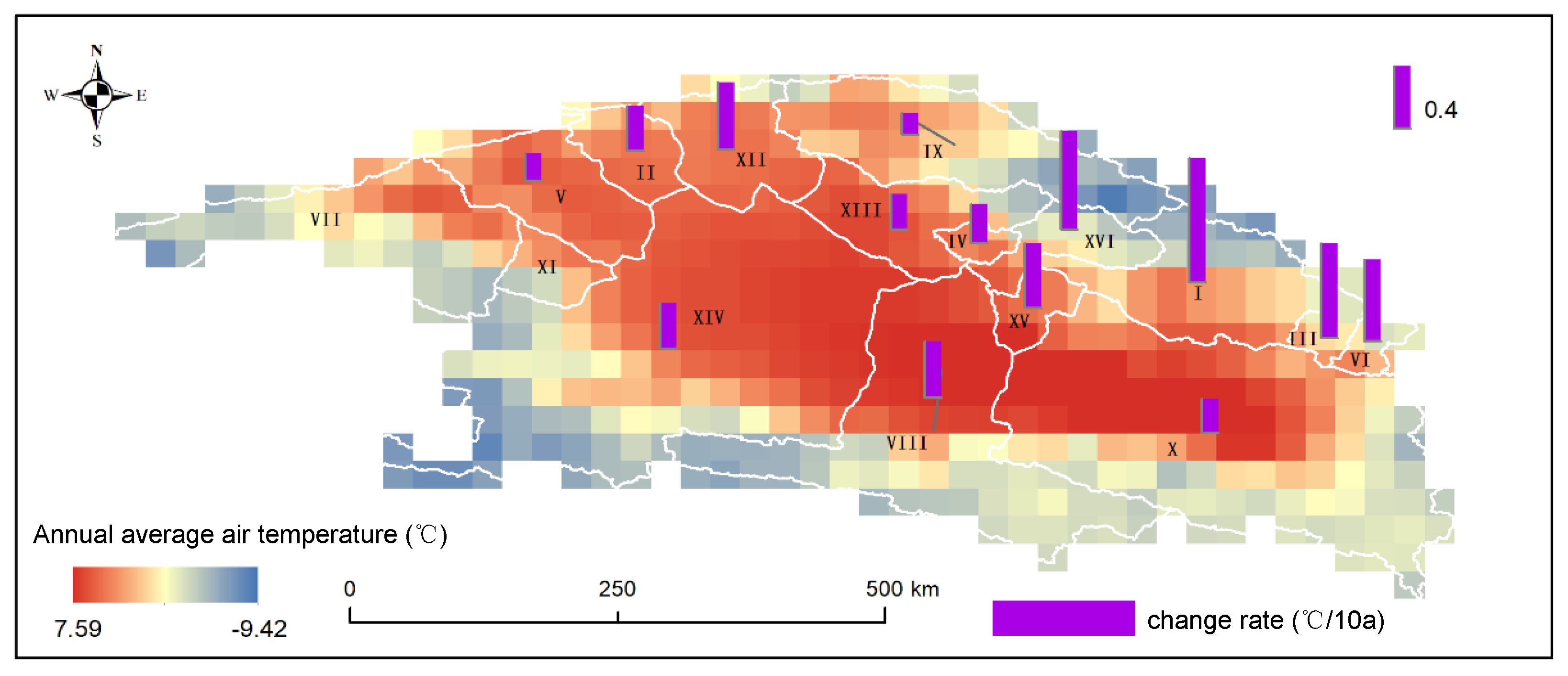
The spatial pattern of air temperature (Figure 11) indicated that the average annual air temperature in Qaidam Basin from 1990 to 2020 was between −9.42℃ and 7.59℃ and were spatially distributed with high air temperature in the middle and low air temperature in the periphery. The rate of change in the air temperature tended to decrease, while that of other areas increased to varying degrees, except for WRZ VII (Gasikule Lake Water System) and XI (Laomangya Lake Water System). There was a relatively high increase in the air temperature of WRZs I, III, VI and XVI northeast of the basin, which were 0.80 °C/10a, 0.61 °C/10a, 0.53 °C/10a and 0.64 °C/10a, respectively. These values were significantly higher than the average change in the rate of air temperature of the basin. There was a relatively low rate of change in the air temperature in the middle and west of the basin.
3.4. Spatiotemporal Changes of Land Cover
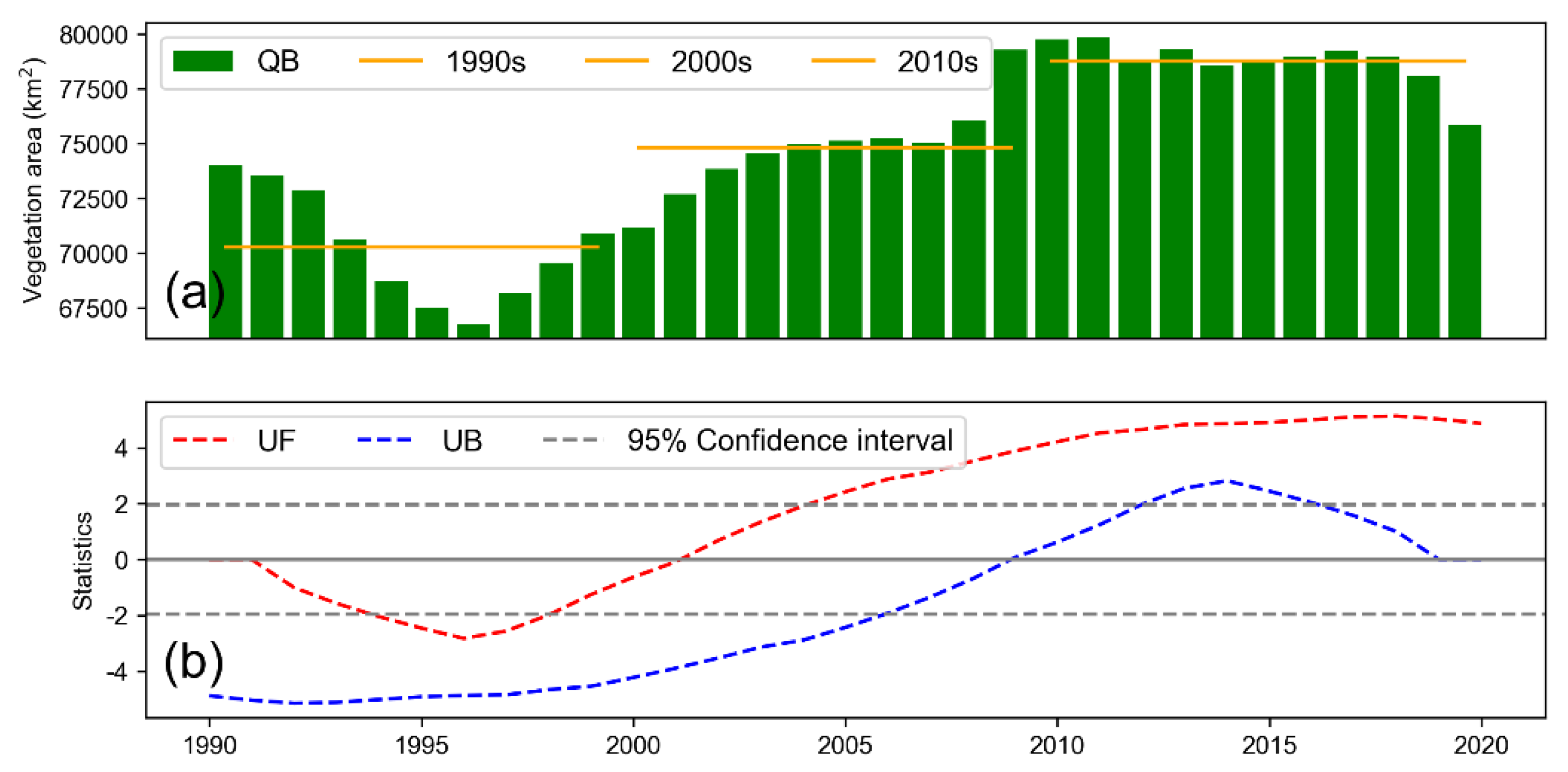
Table 7 and Figure 12 show the characteristics of changes of vegetation area in the Qaidam Basin from 1990 to 2020. The area of vegetation of the basin fluctuated between 66,754.62 km2 (1996) and 79,883.36 km2 (2011) from 1990 to 2020. The vegetation area has increased by 1832.38 km2 over the past 30 years, with a rate of increase of only 2.48%. However, there was still a significant trend of increase overall (QB, Z > 1.96, p < 0.1).
There was a diverse change in the distribution of vegetation (In Supplementary Materials Figure S5), and the area of vegetation in 56.25% of the WRZs (nine in total) tended to significantly increase, particularly since approximately 1995. The change in area of vegetation in 31.25% of the areas (five in total) was not significant, and only two areas of vegetation significantly decreased. The annual average vegetation areas in the 1990s, 2000s and 2010s were 70,268.65, 74,805.98 and 78,762.90 km2, respectively, and the increase was relatively stable.
The results of abrupt change test indicated that there was no abrupt change in the vegetation area of the whole basin and most of the WRZ. The only areas that had significantly abrupt changes in vegetation around 1995 and 2015 were VIII (Golmud Area), XI (Laomangya Lake Water System), XIII (Mahai Lake Water System) and XV (Quanji River/Xiezuo Lake Water System).
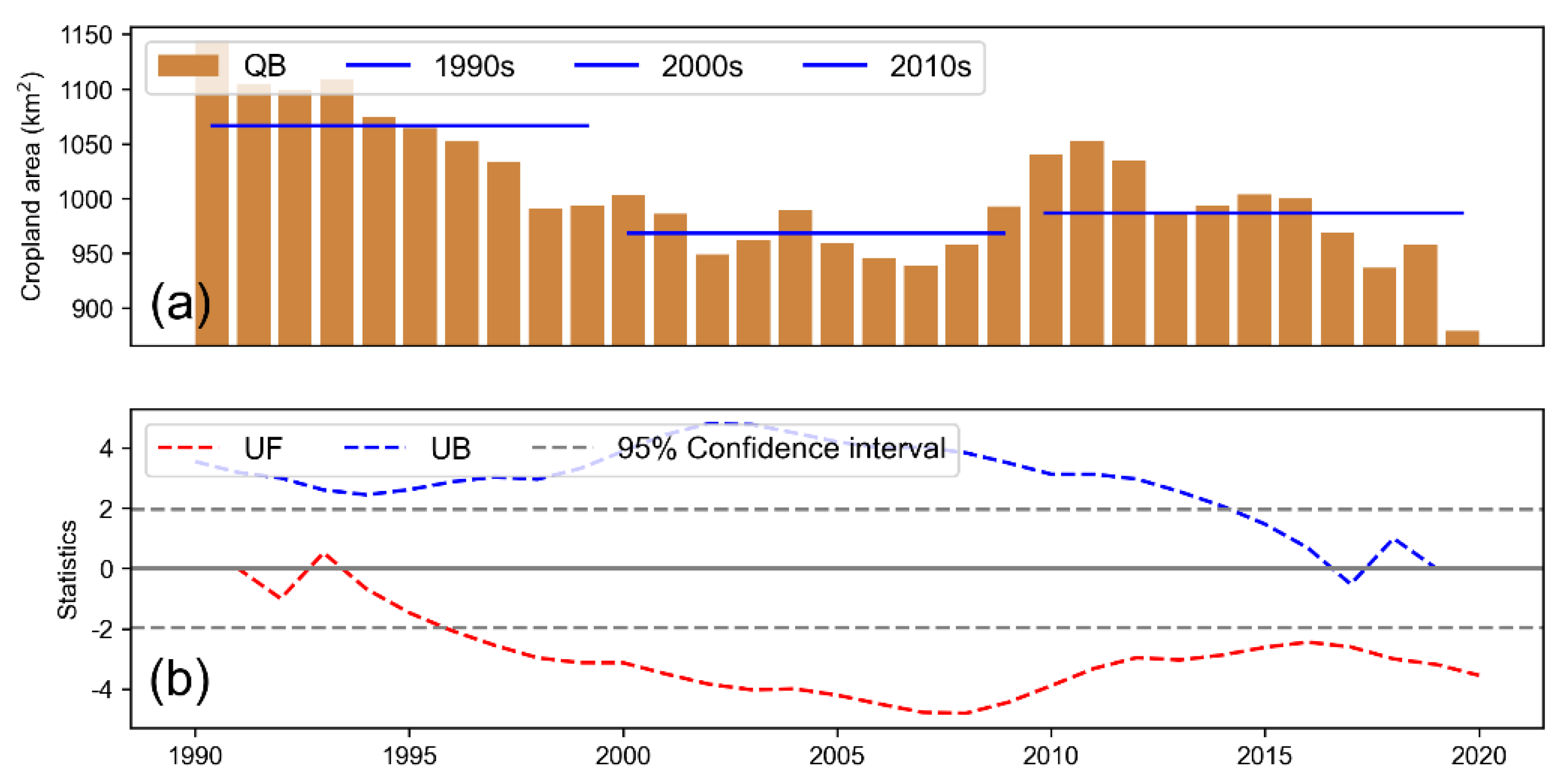
Figure 13 and Table 8 show that the characteristics of cropland area changed from 1990 to 2020 in the Qaidam Basin. The cropland area from 1990 to 2020 fluctuated between 878.73 km2 (2020) and 1,143.77 km2 (1990) with a significant tendency to decrease (Z < -1.96, p > 0.01). Only 62.50% (10) of the cropland area among the 16 WRZs decreased to varying degrees (In Supplementary Materials Figure S6). There were only significant trends of increase in WRZ II (Chahansilatu Dry Saline Area) and VI (Dulan Lake Water System). In summary, the area of cropland primarily decreased from 1990 to 2020. The annual average of the area of cropland in the 1990s was 1066.53 km2, while it was 968.19 km2 in the 2000s, which was a large decrease (9.22%). It increased slightly in the 2010s.
The results of abrupt change test were significant decrease. There was no obvious abrupt change in the overall cropland area of the basin from 1990 to 2020. There were six WRZs that abruptly changed, and the patterns of abrupt change in WRZ II, IV, VI and XIV are relatively similar, which occurred around 1995 and 2015. Abrupt changes in the other areas mostly arose in 2000.
3.5. Responses of Lakes in the Qaidam Basin to Climate Change and Human Activities
3.5.1. Single Factor Correlation of Lake Storage, Climate and Change in Land Cover
Precipitation and evaporation are the primary supply and loss terms of lake water, respectively. Temperatures, on the other hand, indirectly alter the amount of water in lakes by affecting the melting of permafrost and glaciers. Changes in cropland and vegetation area also have potential impacts on changes in lake water storage. Examples include WRZ I, X and XIV of the basin. The water resources in freshwater lakes are used directly for irrigation. The up-stream runoff of salt water or salt lakes is intercepted to irrigate the farmland, and the change in farmland area could have a potential impact on the lake storage. An increase in the area of vegetation can not only alleviate the warming effect of the surface and reduce water evaporation but also reduce the ineffective infiltration and loss of precipitation. This enables the vegetation to contribute to the generation and continuous replenishment of runoff, affecting the runoff into lake.
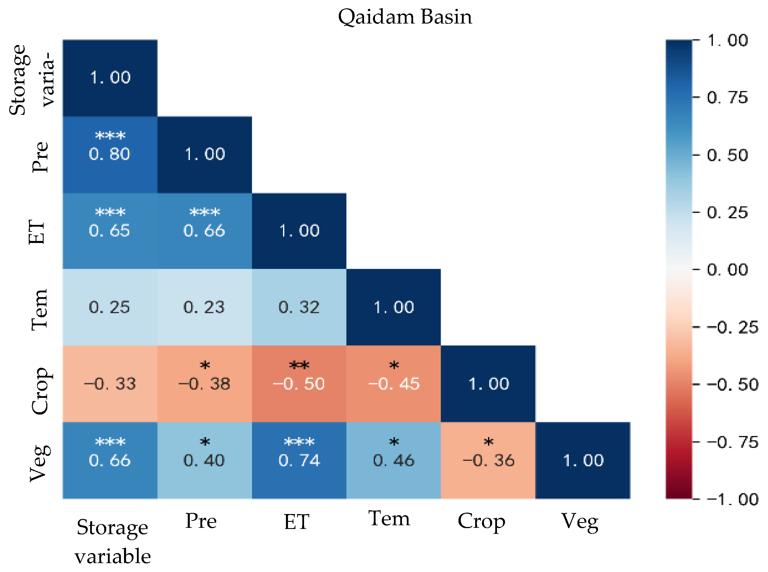
As shown in Figure 14. The elements of the whole basin that are associated with lake storage are precipitation (R = 0.80), vegetation (R = 0.66), and evaporation (R = 0.65). In addition, there is a strong positive correlation (p < 0.001) between evaporation and precipitation (R = 0.66) and evaporation and vegetation (R = 0.74). For each WRZ (In Supplementary Materials Figure S7), except for the Gasikule Lake Water System and Golmud Area, the precipitation and vegetation in the other areas significantly correlated with the lake water volume, indicating that it was significantly affected by the direct supply of precipitation and vegetation. The evaporation of the Chaikai Lake–Keke Salt Lake Water System (R = 0.64), the Dachaidan Lake Water System (R = 0.74), the Huobuxun Lake Water System (R = 0.60) and the Xiaochaidan Lake Water System (R = 0.68) highly correlated with the lake water volume, which was owing to the increase in lake water volume that led to the expansion of lake water surface, resulting in more intense evaporation. There was a significant positive correlation between the air temperature and lake water volume in the Bayin River/Delingha Area (R = 0.46), Chaikai Lake—Keke Salt Lake Water System (R = 0.63), Nalinggele Wutumeiren Area (R = 0.42) and Xiaochaidan Lake Water System (R = 0.54), and the increase in lake water volume was related to the increase in air temperature. The lakes in these areas are supplied by melted water from glaciers. Combined with the analytical results in Section 3, the cause was the increase in water from melting glaciers and the frozen soil caused by the increase in air temperature. There are no glaciers distributed in the Gasikule Lake Water System, and its air temperature negatively correlated with the lake water volume (R = −0.36) because the decrease in air temperature inhibited the evaporation of water. There was a strong negative correlation between the cropland of Xiaochaidan Lake Water System (R = −0.74) and the lake water volume. Combined with the analytical results in Section 3, the reduction in area of cropland led to a reduction in the consumption of irrigation water, which could be the reason for the increase in runoff into the lake.
3.5.2. Degree of the Influence of Climate and Changes in Land Cover on the Lake Water Volume
The correlation analysis of a single factor can only show the influence of a single element on the lake water volume, while the change in lake water volume under particular natural conditions is the result of a comprehensive influence of multiple factors. To further evaluate the influence of different elements on lake water volume, a model of the relationship between lake water volume and multiple factors was established using the method described in Section 2.3.
Table 9 shows the elements that significantly correlated with the lake storage variables in the basin and their standardized coefficients. Combined with the analytical results in Section 3, the increase in total lake water volume in the basin significantly correlated with the increase in precipitation and area of vegetation. Precipitation was the main factor (Beta = 0.64), while vegetation was the secondary factor (Beta = 0.40). No significant elements that affect the water volume of the lakes in WRZ VII and VIII have been identified. Precipitation is still an important factor that affects the lake water volume in the other WRZs, and the precipitation in WRZ I (Beta = 0.71) and X (Beta = 0.58) contributes the most to the change in lake water volume. However, evaporation is not a significant element that affects the lake water volume, and it did not pass the significance test in all the WRZs owing to the marked increase in evaporation (Section 3.3). Although the amount of evaporation can indicate the loss of lake storage to some extent, the increase in precipitation is more significant, and the actual water volume of most of the lakes also increased. Therefore, the “side effects” owing to the increase in evaporation cannot be effectively reflected. The lake water volume in WRZ III and IX increased owing to air temperature. The increase in lake water volume in WRZ III positively correlated with air temperature, but there is no glacier in this area. When the impact of temperature on the water volume of lakes is considered, the increase in water volume of lakes in this area could be correlated with the melting of frozen soil caused by the increase in air temperature. In contrast, the increase in lake water volume in Area IX was related to the decrease in air temperature, which could inhibit the evaporation of lake water. However, the reduction in temperature plays a limited role (Beta = 0.27).
The change in land cover somewhat contributed to the change in lake water volume, but the change in cropland area in each WRZ did not significantly contribute to the lake water volume. The expansion of vegetation area significantly contributed to the lake water volume in 66.67% of the area, and the change in vegetation in the other areas was the main factor except for WRZ X. This shows that when the amount of precipitation increases, an increase in the area of vegetation in the basin helps the precipitation to form runoff, which then promotes the effective supply of lake water volume. In summary, precipitation has made a major contribution to the increase in lake water volume in the whole basin, while vegetation plays an important role in the increase in lake water volume in each WRZ.
3.5.3. Influence of Human Activities on Lake Changes
The lakes in the central Qaidam Basin are the most significantly affected by human activities. Industrial activities, such as brine mining, salt field construction and damming, have led to dramatic changes in the spatial pattern of lakes in the central basin for decades. An analysis of the time sequence showed that there was relatively little industrial activity in the central basin from 1990 to 2000. Except for the slight increase in the water volume of East Taijinar Lake, the water volume of other lakes decreased to varying degrees. The shrinkage of water surface of West Taijinar Lake was the most obvious, which was caused by underground brine mining and the diversion of lake water to East Taijinar Lake.
The total lake water volume in the central basin increased significantly from 2000 to 2010. CITIC Guoan Science and Technology Development Co., Ltd. (Gelmud, China) (2003) and Qinghai Lithium Co., Ltd. (2008) dammed the east and west sides of West and East Taijinar, respectively, to maintain brine mining, resulting in the rapid increase in the water volume of Yahu Lake (25) by 0.33 km3 [18]. Part of the lake water flows into the northern area of West Taijinar Lake and forms another new lake (Yiliping Lake, 23). This new lake was the largest in the basin in 2010, with an increase of 0.29 km3 in water volume. In addition, dams have been built in the west of Senie Lake (28) and Dabsan Lake (9), which formed the two lakes Noname2 (27) and Noname3 (8), respectively.
China Minmetals Corporation (Beijing, China) (2013) dammed south of Yiliping Lake from 2010 to 2020 to block water and runoff into the lake to mine underground brine and build salt fields. Since then, Yiliping Lake has rapidly dried up, and the lake water volume decreased by 0.29 km3 in one year. Except for the western salt field, Yiliping Lake has almost completely dried up. Simultaneously, the dam to the west of Yahu Lake blocks a large amount of incoming water, and its water volume increased rapidly, with a rate of increase of 0.08 km3/a and an increase of 0.81 km3. In contrast, the damming and salt field construction around Dabsan Lake had little impact on its water volume, indicating that the salt lake mining in this area is relatively reasonable for the area.
In summary, brine mining and damming activities in the central basin are the primary factors that affect the change in lake water volume. Lakes not only function to regulate the regional microclimate; they are also important resources for local economic development. The development of salt lakes will inevitably bring challenges to the sustainable development of lake resources and the stability of regional climate. The question of how to coordinate ecological protection and economic development and formulate reasonable policies for salt lake development from the perspective of sustainable development are major challenges faced by the local authorities.
4. Conclusions
Taking the lakes in Qaidam Basin in the inland arid region of China as the study object and combining multi-source remote sensing, model simulation, and historical data, this study comprehensively analyzed the characteristics and driving forces of climate and lake water volume in the basin. The main conclusions are as follows:
- The total lake water volume in the basin tended to first decrease and then increase from 1990 to 2020, with a net increase of 3.81 km3. There were decreasing abrupt changes and increasing abrupt changes around 1995 and 2015, respectively. The Bayin River/Delingha Area is the primary area that contributes to the increase in lake water in the basin.
- From 1990 to 2020, the precipitation had a significant abrupt change, which was similar to the abrupt pattern of change in lake water volume. However, the changes of other meteorological elements were not significant. The vegetation area increases significantly. In contrast, the cropland area significantly decreased, but neither of them abruptly changed significantly.
- The increase in precipitation was the primary reason for the increase in lake water volume (Beta = 0.64), while the increase in vegetation area was the secondary reason (Beta = 0.40). Changes in the air temperature, evaporation, and cropland area had little effect on the total lake water volume.
- Since the 21st century, with the continuous development of the salt lake industry, damming to block water has led to dramatic changes in Lakes. The disappearance of Yiliping Lake and the emergence of new lakes will inevitably lead to regional microclimate changes. The suggestion that reasonable local policies should be formulated for salt lake development to prevent ecological risks caused by lake changes.
Supplementary Materials
The following supporting information can be downloaded at: https://www.mdpi.com/article/10.3390/w14193141/s1, Figure S1: Changes in water storage of major lakes in the Qaidam Basin from 1990 to 2020. The odd-numbered lines show the water volume change, the unit is km3. The even-numbered lines show the Mann-Kendall test results; Figure S2: Precipitation for each water resources zones (WRZ) in the Qaidam Basin from 1990 to 2020. Odd-numbered lines show precipitation, the unit is mm. Even-numbered lines show Mann-Kendall test results; Figure S3: Evaporation for each water resources zones (WRZ) in the Qaidam Basin from 1990 to 2020. Odd-numbered lines show evaporation, the unit is mm. Even-numbered lines show Mann-Kendall test results; Figure S4: Air temperature for each water resources zones (WRZ) in the Qaidam Basin from 1990 to 2020. Odd-numbered lines show air temperature, the unit is ℃. Even-numbered lines show Mann-Kendall test results; Figure S5: Vegetation area for each water resources zones (WRZ) in the Qaidam Basin from 1990 to 2020. Odd-numbered lines show vegetation area, the unit is km2. Even-numbered lines show Mann-Kendall test results; Figure S6: Cropland area for each water resources zones (WRZ) in the Qaidam Basin from 1990 to 2020. Odd-numbered lines show cropland area, the unit is km2. Even-numbered lines show Mann-Kendall test results; Figure S7: Correlation among Lake Storage, Climate and Land Cover elements in in each WRZ. Pre: precipitation; Eva: evapotranspiration; Tem: air temperature; CL: cropland; Veg: vegetation. * denotes p-value < 0.05, ** denotes p-value < 0.01, *** denotes p-value < 0.001.
Author Contributions
Conceptualization, A.L; methodology, C.Z.; formal analysis, A.L; i writing—original draft preparation, C.Z.; writing—review and editing, A.L.; supervision, A.L.; project administration and funding acquisition, A.L. All authors have read and agreed to the published version of the manuscript.
Funding
This research was funded the Important Science & Technology Specific Projects of Qinghai Province (2019-SF-A4–1) and the National Natural Science Foundation of China (41671026).
Data Availability Statement
Data is contained within the article or Supplementary Material.
Acknowledgments
We would like to thank the editors and anonymous reviewers for their constructive comments and suggestions. Thanks also go to the teams at TPDC, NASA, ESA and Copernicus who have made their datasets available and free for use.
Conflicts of Interest
The authors declare no conflict of interest.
References
- Yechieli, Y.; Ronen, D.; Berkowitz, B.; Dershowitz, W.S.; Hadad, A. Aquifer Characteristics Derived From the Interaction Between Water Levels of a Terminal Lake (Dead Sea) and an Adjacent Aquifer. Water Resour. Res. 1995, 31, 893–902. [Google Scholar] [CrossRef]
- Zhu, L.; Peng, P.; Zhang, G.; Qiao, B.; Liu, C.; Yang, R.; Wang, J. The Role of Tibetan Plateau Lakes in Surface Water Cycle under Global Changes. J Lake Sci. 2020, 32, 597–608. [Google Scholar]
- Ma, R.; Duan, H.; Hu, C.; Feng, X.; Li, A.; Ju, W.; Juang, J.; Yang, G. A half-century of changes in China’s lakes: Global warming or human influence? Geophys. Res. Lett. 2010, 37. [Google Scholar] [CrossRef]
- Ma, R.; Yang, G.; Duan, H.; Jiang, J.; Wang, S.; Feng, X.; Li, A.; Kong, F.; Xue, B.; Wu, J. Number, Area and Spatial Distribution of Lakes in China. Sci. China Earth Sci. 2011, 41, 394–401. [Google Scholar]
- Zhu, L.; Zhang, G.; Yang, R.; Liu, C.; Yang, K.; Qiao, B.; Han, B. Lake Variations on Tibetan Plateau of Recent 40 Years and Future Changing Tendency. Bull. Chin. Acad. Sci. 2019, 34, 1254–1263. [Google Scholar] [CrossRef] [Green Version]
- Jiang, L.; Nielsen, K.; Andersen, O.B.; Bauer-Gottwein, P. Monitoring recent lake level variations on the Tibetan Plateau using CryoSat-2 SARIn mode data. J. Hydrol. 2017, 544, 109–124. [Google Scholar] [CrossRef] [Green Version]
- Wan, W.; Xiao, P.; Feng, X.; Li, H.; Ma, R.; Duan, H. Satellite Remote Sensing Monitoring of Lake Changes in the Qinghai-Tibet Plateau in Recent 30 Years. Chin. Sci. Bull. 2014, 59, 701–714. [Google Scholar] [CrossRef]
- Zhang, G.; Wang, M.; Zhou, T.; Chen, W.F. Progress in Remote Sensing Monitoring of Lake Area, Water Level, and Volume Changes on the Tibetan Plateau. Natl. Remote Sens. Bull. 2022, 26, 115–125. [Google Scholar]
- Zhang, W.; Song, C. Spatial Distribution and Dynamics of Lakes in China: Progress in Remote Sensing Monitoring at National Scale and New Inventory of the Maximum Lake Extent and Change Trajectory. Natl. Remote Sens. Bull. 2022, 26, 92–103. [Google Scholar]
- Adrian, R.; O’reilly, C.M.; Zagarese, H.; Baines, S.B.; Hessen, D.O.; Keller, W.; Livingstone, D.M.; Sommaruga, R.; Straile, D.; Van Donk, E.; et al. Lakes as sentinels of climate change. Limnol. Oceanogr. 2009, 54, 2283–2297. [Google Scholar] [CrossRef] [PubMed] [Green Version]
- Zhang, G.; Duan, S. Lakes as sentinels of climate change on the Tibetan Plateau. All Earth 2021, 33, 161–165. [Google Scholar] [CrossRef]
- Zhang, G.; Yao, T.; Shum, C.K.; Yi, S.; Yang, K.; Xie, H.; Feng, W.; Bolch, T.; Wang, L.; Behrangi, A.; et al. Lake volume and groundwater storage variations in Tibetan Plateau’s endorheic basin. Geophys. Res. Lett. 2017, 44, 5550–5560. [Google Scholar] [CrossRef]
- Gegen, B.; Wei, W.; Zhang, X.; Yang, X.; Shi, Z. Spatiotemporal Trends and Periodic Features of Climate Extremes over the Qaidam Basin. Arid Reg. Study 2020, 37, 304–313. [Google Scholar]
- Hu, R.J.; Jiang, F.Q.; Wang, Y.J. On the Importance of Research on the Lakes in Arid Land of China. Arid. Reg. Study 2007, 24, 137–140. [Google Scholar]
- Wang, X.; Yang, M.; Liang, X.; Pang, G.; Wan, G.; Chen, X.; Luo, X. The dramatic climate warming in the Qaidam Basin, northeastern Tibetan Plateau, during 1961–2010. Int. J. Climatol. 2014, 34, 1524–1537. [Google Scholar] [CrossRef]
- Huo, T.; Yan, W.; Ma, X. A Study of the Variation and Driving Factors of the Water Area of the Terminal Lake of Inland River: A Case Study of Taitema Lake region. Remote Sens. Nat. Resour. 2020, 32, 149–156. [Google Scholar]
- Du Yu’e Liu, B.; He, W.; Zhou, J.; Duan, S. Analysis on the variation and cause of the lake area in Qaidam Basin from 1976 to 2017. J. Glaciol. Geocryol. 2018, 40, 1275–1284. [Google Scholar]
- Duan, S. Lake Evolution in the Qaidam Basin during 1976–2015 and Their Changes in Response to Climate and Anthropogenic Factors. J. Lake Sci. 2018, 30, 256–265. [Google Scholar]
- Wei, S.; Jin, X.; Wang, K.; Liang, H. Response of Lake Area Variation to Climate Change in Qaidam Basin Based on Remote Sensing. Earth Sci. Front. 2017, 24, 427–433. [Google Scholar]
- Wu, S.; Lu, X. Research on the Prediction Model of the Financial Distress of Listed Companies in China. Econ. Res. J. 2001, 46–55+96. [Google Scholar]
- Liu, Y.; Li, J. Geographic Detection and Optimizing Decision of the Differentiation Mechanism of Rural Poverty in China. Acta Geogr. Sin. 2017, 72, 161–173. [Google Scholar]
- Dong, S.; Xue, X.; You, Q.; Fei, P. Remote Sensing Monitoring of the Lake Area Changes in the Qinghai-Tibet Plateau in Recent 40 Years. J. Lake Sci. 2014, 26, 535–544. [Google Scholar]
- Tan, Y. Water System, Surface Water Resources and Their Characteristics in Qaidam Basin. Water Conserv. Sci. Technol. Econ. 2014, 20, 51–54. [Google Scholar]
- Zhang, C.; Lv, A.; Jia, S.; Qi, S. Longterm multisource satellite data fusion reveals dynamic expansion of lake water area and storage in a hyperarid basin of China. J. Hydrol. 2022, 610, 127888. [Google Scholar] [CrossRef]
- Zhang, G. Lake Water Volume Changes on the Tibetan Plateau during 1976–2020 (>1 km2) v2.0; National Tibetan Plateau Data Center: Beijing, China, 2021. [Google Scholar]
- Xu, Z.; Wu, Z.; He, H.; Wu, X.; Zhou, J.; Zhang, Y.; Guo, X. Evaluating the accuracy of MSWEP V2. 1 and its performance for drought monitoring over mainland China. Atmos. Res. 2019, 226, 17–31. [Google Scholar] [CrossRef]
- Ruan, Y.; Wu, X. Evaluation of Groundwater Resource Sustainability Based on GRACE and GLDAS in Arid Region of Northwest China. Arid. Reg. Study 2022, 39, 787–800. [Google Scholar]
- Zhu, N. Comprehensive Assessment of Drought in the Tarim River Basin Based on GLDAS and GRACE Data. Ph.D. Thesis, East China Normal University, Shangai, China, 2020. [Google Scholar]
- Yang, J.; Huang, X. The 30 m annual land cover dataset and its dynamics in China from 1990 to 2019. Earth Syst. Sci. Data 2021, 13, 3907–3925. [Google Scholar] [CrossRef]
- Li, S.; Zhang, B.; Ma, B.; Hou, Q.; He, H. Spatiotemporal Evolution of Effective Accumulated Temperatures of ≥5 ℃ and ≥10 ℃ Based on Grid Data in China from 1961 to 2016. Chin. J. Nat. Resour. 2020, 35, 1216–1227. [Google Scholar]
- Liu, Z.; Huang, Y.; Liu, T.; Bao, A.; Feng, X.; Xing, W.; Duan, Y.; Guo, C. Climate Change and Its Effects on Runoff at the Headwater of Kaidu River. Arid. Reg. Study 2020, 37, 418–427. [Google Scholar]
Figure 1.
Study area.

Figure 2.
Flow chart of correlation analysis.

Figure 3.
Comparison of lake storage variables obtained from different data sources from 1990 to 2019.
Figure 3.
Comparison of lake storage variables obtained from different data sources from 1990 to 2019.

Figure 4.
(a) The lake storage variable of Qaidam Basin from 1990 to 2020. The orange solid line represents the decade average of the change in lake storage variable. (b) Mann-Kendall test results of lake storage variable.
Figure 4.
(a) The lake storage variable of Qaidam Basin from 1990 to 2020. The orange solid line represents the decade average of the change in lake storage variable. (b) Mann-Kendall test results of lake storage variable.

Figure 5.
Spatial pattern of the lake storage variable in the Qaidam Basin from 1990 to 2020. Green, yellow, and red histograms represent the lake storage variable for different decades in each WRZ, with a scalar in the upper right corner.
Figure 5.
Spatial pattern of the lake storage variable in the Qaidam Basin from 1990 to 2020. Green, yellow, and red histograms represent the lake storage variable for different decades in each WRZ, with a scalar in the upper right corner.

Figure 6.
(a) Change of precipitation in the Qaidam Basin from 1990 to 2020. The orange solid line represents the decade average of the change in Precipitation. (b) Mann-Kendall test results of precipitation.
Figure 6.
(a) Change of precipitation in the Qaidam Basin from 1990 to 2020. The orange solid line represents the decade average of the change in Precipitation. (b) Mann-Kendall test results of precipitation.

Figure 7.
Spatial pattern of precipitation in the Qaidam Basin from 1990 to 2020. Green, yellow, and red histograms represent the annual average precipitation for different decades in each WRZ, with a scalar in the upper right corner.
Figure 7.
Spatial pattern of precipitation in the Qaidam Basin from 1990 to 2020. Green, yellow, and red histograms represent the annual average precipitation for different decades in each WRZ, with a scalar in the upper right corner.

Figure 8.
(a) Change in evaporation in the Qaidam Basin from 1990 to 2020. The blue solid line represents the decade average of the change in Evaporation. (b) Mann-Kendall test results of evaporation.
Figure 8.
(a) Change in evaporation in the Qaidam Basin from 1990 to 2020. The blue solid line represents the decade average of the change in Evaporation. (b) Mann-Kendall test results of evaporation.

Figure 9.
Spatial pattern of evaporation in the Qaidam Basin from 1990 to 2020. Green, yellow, and red histograms represent the annual average evaporation for different decades in each WRZ, with a scalar in the upper right corner.
Figure 9.
Spatial pattern of evaporation in the Qaidam Basin from 1990 to 2020. Green, yellow, and red histograms represent the annual average evaporation for different decades in each WRZ, with a scalar in the upper right corner.

Figure 10.
(a) Air temperature changes in the Qaidam Basin from 1990 to 2020. The blue solid line represents the decade average of the change in Evaporation. (b) Mann-Kendall test results of air temperature in Qaidam Basin.
Figure 10.
(a) Air temperature changes in the Qaidam Basin from 1990 to 2020. The blue solid line represents the decade average of the change in Evaporation. (b) Mann-Kendall test results of air temperature in Qaidam Basin.

Figure 11.
Spatial pattern of air temperature in the Qaidam Basin from 1990 to 2020. The purple histogram shows the rate of change in air temperature for each WRZ, with a scalar in the upper right corner.
Figure 11.
Spatial pattern of air temperature in the Qaidam Basin from 1990 to 2020. The purple histogram shows the rate of change in air temperature for each WRZ, with a scalar in the upper right corner.

Figure 12.
(a) Changes of vegetation areas in the Qaidam Basin from 1990 to 2020. (b) Mann-Kendall test results of vegetation in Qaidam Basin.
Figure 12.
(a) Changes of vegetation areas in the Qaidam Basin from 1990 to 2020. (b) Mann-Kendall test results of vegetation in Qaidam Basin.

Figure 13.
(a) Changes in cropland in the Qaidam Basin from 1990 to 2020. (b) Mann-Kendall test results of cropland in Qaidam Basin.
Figure 13.
(a) Changes in cropland in the Qaidam Basin from 1990 to 2020. (b) Mann-Kendall test results of cropland in Qaidam Basin.

Figure 14.
Correlation among lake storage, climate and land cover elements in the Qaidam Basin. Pre: precipitation; Eva: evapotranspiration; Tem: air temperature; CL: cropland; Veg: vegetation. * denotes p-value < 0.05, ** denotes p-value < 0.01, *** denotes p-value < 0.001.
Figure 14.
Correlation among lake storage, climate and land cover elements in the Qaidam Basin. Pre: precipitation; Eva: evapotranspiration; Tem: air temperature; CL: cropland; Veg: vegetation. * denotes p-value < 0.05, ** denotes p-value < 0.01, *** denotes p-value < 0.001.


Table 1.
Names and ID of level 4 water resource zones and lakes in the Qaidam Basin.
| WRZ and ID | Lakes and ID |
|---|---|
| I. Bayin River/Delingha Area | 1. Gahai Lake, 2. Keluke Lake, 3. Tuosu Lake |
| II. Chahansilatu Dry Saline Area | - |
| III. Chaikai Lake—Keke Salt Lake Water System | 4. Keke Salt Lake |
| IV. Dachaidan Lake Water System | 5. Dachaidan Lake |
| V. Dalangtan-Fengnan Dry Salina Area | - |
| VI. Dulan Lake Water System | 6. Xiligou Lake |
| VII. Gasikule Lake Water System | 7. Gasikule Lake |
| VIII. Golmud Area | 8. Noname2, 9. Dabuxun Lake, 10. Small Kusai Lake, 11. Black Sea, 12. Noname1, 13. Cabanualdo Lake, 14. Cuoriabu Ri’adong Lake, 15. Cuomudoujiangzhang Lake |
| IX. Haerteng River/Sugan Lake Area | 16. Sugan Lake, 17. Xiaosugan Lake |
| X. Huobuxun Lake Water System | 18. South Huobuxun Lake, 19. North Huobuxun Lake, 20. Alake Lake, 21. Donggi Conag Lake, 22. Doucuo Lake |
| XI. Laomangya Lake Water System | - |
| XII. Lenghu Lake Surrounding Area | - |
| XIII. Mahai Lake Water System | - |
| XIV. Nalinggele Wutumeiren Area | 23. Yiliping Salt Lake, 24. West Taijinar Lake, 25. Yahu Lake, 26. East Taijinar Lake, 27. Noname3, 28. Senie Lake, 29, Sun Lake, 30. Kushuihuan Lake |
| XV. Quanji River/Xiezuo Lake Water System | – |
| XVI. Xiaochaidan Lake Water System | 31. Xiaochaidan Lake |
Table 2.
Data used in this study.
| Category | Name | Time Span | Resolution (Spatial/Temporal) |
|---|---|---|---|
| Lake storage variable | QB_LWSC | 1990–2020 | -, 1 a |
| TPDC_LWSC | 1990–2019 | -, 5 a | |
| Meteorological element | MSWEP_precipitation | 1990–2020 | 0.1°, 1 d |
| GLDAS_air temperature | 0.25°, 30 d | ||
| GLDAS_evaporation | 0.25°, 30 d | ||
| Land cover | CLCD | 30 m, 1 a |
Table 3.
Trend of change in lake water storage in the Qaidam Basin from 1990 to 2020.
| Lake ID | Change Trend | Z | P | Lake ID | Change Trend | Z | P |
|---|---|---|---|---|---|---|---|
| QB | Significant increase | 3.47 | 0.00 | 18 | Significant increase | 5.52 | 0.00 |
| 1 | Significant increase | 5.49 | 0.00 | 19 | Significant decrease | −3.94 | 0.00 |
| 3 | Significant increase | 2.37 | 0.02 | 21 | Significant increase | 3.23 | 0.00 |
| 4 | Significant increase | 5.25 | 0.00 | 23 | Significant increase | 2.88 | 0.00 |
| 5 | Significant increase | 4.09 | 0.00 | 24 | Significant decrease | −4.29 | 0.00 |
| 7 | Significant increase | 2.73 | 0.01 | 25 | Significant increase | 6.57 | 0.00 |
| 9 | Not significant | 0.56 | 0.57 | 26 | Not significant | −0.42 | 0.68 |
| 16 | Significant increase | 4.39 | 0.00 | 31 | Significant increase | 5.51 | 0.00 |
Table 4.
Test results of the trend test of precipitation in the Qaidam Basin from 1990 to 2020.
| WRZ | Change Trend | Z | P | WRZ | Change Trend | Z | P |
|---|---|---|---|---|---|---|---|
| QB | Significant increase | 3.40 | 0.00 | IX | Significant increase | 4.05 | 0.00 |
| I | Significant increase | 2.72 | 0.01 | X | Significant increase | 4.25 | 0.00 |
| II | Significant increase | 2.45 | 0.01 | XI | Significant increase | 2.04 | 0.04 |
| III | Significant increase | 3.20 | 0.00 | XII | Increase | 1.84 | 0.07 |
| IV | Significant increase | 2.72 | 0.01 | XIII | Significant increase | 3.09 | 0.00 |
| V | Increase | 1.77 | 0.08 | XIV | Significant increase | 4.28 | 0.00 |
| VI | Significant increase | 2.14 | 0.03 | XV | Significant increase | 3.91 | 0.00 |
| VII | Significant increase | 2.92 | 0.00 | XVI | Significant increase | 3.03 | 0.00 |
| VIII | Not significant | 1.36 | 0.17 |
Table 5.
Test results of the actual evaporation trend in the Qaidam Basin from 1990 to 2020.
| WRZ | Change Trend | Z | P | WRZ | Change Trend | Z | P |
|---|---|---|---|---|---|---|---|
| QB | Significant increase | 4.39 | 0.00 | Ⅸ | Significant increase | 4.01 | 0.00 |
| Ⅰ | Significant increase | 2.31 | 0.02 | Ⅹ | Significant increase | 3.60 | 0.00 |
| Ⅱ | Significant increase | 4.01 | 0.00 | Ⅺ | Significant increase | 4.76 | 0.00 |
| Ⅲ | Significant increase | 4.18 | 0.00 | Ⅻ | Significant increase | 1.97 | 0.05 |
| Ⅳ | Significant increase | 3.64 | 0.00 | XIII | Significant increase | 2.41 | 0.02 |
| Ⅴ | Significant increase | 2.65 | 0.01 | XIV | No trend | 1.09 | 0.28 |
| Ⅵ | Significant increase | 3.50 | 0.00 | XV | Significant increase | 3.77 | 0.00 |
| Ⅶ | Significant increase | 4.18 | 0.00 | XVI | Significant increase | 3.60 | 0.00 |
| Ⅷ | Significant increase | 2.55 | 0.01 |
Table 6.
Test results of the air temperature trend in the Qaidam Basin from 1990 to 2020.
| WRZ | Change Trend | Z | P | WRZ | Change Trend | Z | P |
|---|---|---|---|---|---|---|---|
| QB | Significant increase | 2.52 | 0.01 | Ⅸ | Not significant | 0.78 | 0.43 |
| Ⅰ | Significant increase | 3.43 | 0.00 | Ⅹ | Increase | 1.90 | 0.06 |
| Ⅱ | Significant increase | 2.35 | 0.02 | Ⅺ | Not significant | −0.82 | 0.41 |
| Ⅲ | Significant increase | 3.13 | 0.00 | Ⅻ | Significant increase | 3.54 | 0.00 |
| Ⅳ | Significant increase | 2.11 | 0.04 | XIII | Significant increase | 2.01 | 0.04 |
| Ⅴ | Not significant | 0.95 | 0.34 | XIV | Significant increase | 2.52 | 0.01 |
| Ⅵ | Significant increase | 2.86 | 0.00 | XV | Significant increase | 2.79 | 0.01 |
| Ⅶ | Significant decrease | -2.04 | 0.04 | XVI | Significant increase | 3.50 | 0.00 |
| Ⅷ | Significant increase | 3.16 | 0.00 |
Table 7.
Test results of the vegetation area trend in the Qaidam Basin from 1990 to 2020.
| WRZ | Change Trend | Z | P | WRZ | Change Trend | Z | P |
|---|---|---|---|---|---|---|---|
| QB | Significant increase | 4.73 | 0.00 | Ⅸ | Significant increase | 5.81 | 0.00 |
| Ⅰ | Significant increase | 5.91 | 0.00 | Ⅹ | Significant increase | 2.79 | 0.01 |
| Ⅱ | Significant decrease | -3.84 | 0.00 | Ⅺ | Not significant | 0.68 | 0.50 |
| Ⅲ | Significant increase | 4.35 | 0.00 | Ⅻ | Not significant | -1.46 | 0.14 |
| Ⅳ | Significant increase | 4.79 | 0.00 | XIII | Not significant | -0.88 | 0.38 |
| Ⅴ | Significant decrease | -4.28 | 0.00 | XIV | Significant increase | 4.05 | 0.00 |
| Ⅵ | Significant increase | 5.34 | 0.00 | XV | Not significant | -0.82 | 0.41 |
| Ⅶ | Significant increase | 4.56 | 0.00 | XVI | Significant increase | 6.02 | 0.00 |
| Ⅷ | Not significant | 0.17 | 0.87 |
Table 8.
Test results of the trend towards cropland area in the Qaidam Basin from 1990 to 2020.
| WRZ | Change Trend | Z | P | WRZ | Change Trend | Z | P |
|---|---|---|---|---|---|---|---|
| QB | Significant decrease | −3.88 | 0.00 | Ⅸ | Significant decrease | −5.47 | 0.00 |
| Ⅰ | Significant decrease | −3.37 | 0.00 | Ⅹ | Not significant | −1.60 | 0.11 |
| Ⅱ | Significant increase | 4.97 | 0.00 | Ⅺ | Significant decrease | −4.73 | 0.00 |
| Ⅲ | Not significant | −1.12 | 0.26 | Ⅻ | Significant decrease | −5.66 | 0.00 |
| Ⅳ | Not significant | 0.99 | 0.32 | XIII | Significant decrease | −7.24 | 0.00 |
| Ⅴ | Significant decrease | −3.65 | 0.00 | XIV | Decrease | −1.70 | 0.09 |
| Ⅵ | Significant increase | 2.69 | 0.01 | XV | Significant decrease | −4.88 | 0.00 |
| Ⅶ | Significant decrease | −5.18 | 0.00 | XVI | Significant decrease | −4.40 | 0.00 |
| Ⅷ | Significant decrease | −3.57 | 0.00 |
Table 9.
Significant correlation elements and their standardized coefficients of lake storage variables. WRZ: Water Resources Zone; Pre: precipitation; Eva: evapotranspiration; Tem: air temperature; CL: cropland; Veg: vegetation.
Table 9.
Significant correlation elements and their standardized coefficients of lake storage variables. WRZ: Water Resources Zone; Pre: precipitation; Eva: evapotranspiration; Tem: air temperature; CL: cropland; Veg: vegetation.
| WRZ ID | Lake ID | Significant Correlation Element (0.05) and Standardized Coefficient Beta | Model’s R | ||||
|---|---|---|---|---|---|---|---|
| Pre | ET | Tem | Crop | Veg | |||
| QB | All | 0.64 | - | - | - | 0.40 | 0.88 |
| Ⅰ | 1, 3 | 0.71 | - | - | - | - | 0.71 |
| Ⅲ | 4 | - | - | 0.41 | - | 0.52 | 0.78 |
| Ⅳ | 5 | - | - | - | - | 0.71 | 0.71 |
| Ⅶ | 7 | - | - | - | - | - | |
| Ⅷ | 9 | - | - | - | - | - | |
| Ⅸ | 16 | 0.21 | - | −0.27 | - | 0.76 | 0.90 |
| Ⅹ | 18, 19, 21 | 0.58 | - | - | - | 0.50 | 0.81 |
| XIV | 23, 24, 25, 26 | 0.41 | - | - | - | 0.51 | 0.72 |
| XVI | 31 | 0.51 | - | - | - | 0.53 | 0.86 |
Bold is used to highlight the main factors that affect the lake storage variables.
Publisher’s Note: MDPI stays neutral with regard to jurisdictional claims in published maps and institutional affiliations. |
© 2022 by the authors. Licensee MDPI, Basel, Switzerland. This article is an open access article distributed under the terms and conditions of the Creative Commons Attribution (CC BY) license (https://creativecommons.org/licenses/by/4.0/).
Share and Cite
MDPI and ACS Style
Lv, A.; Zhang, C. Analysis of the Characteristics and Driving Forces of Changes in Lake Water Volume in Inland Arid Basins in China. Water 2022, 14, 3141. https://doi.org/10.3390/w14193141
AMA Style
Lv A, Zhang C. Analysis of the Characteristics and Driving Forces of Changes in Lake Water Volume in Inland Arid Basins in China. Water. 2022; 14(19):3141. https://doi.org/10.3390/w14193141
Chicago/Turabian StyleLv, Aifeng, and Chuanhui Zhang. 2022. "Analysis of the Characteristics and Driving Forces of Changes in Lake Water Volume in Inland Arid Basins in China" Water 14, no. 19: 3141. https://doi.org/10.3390/w14193141
Note that from the first issue of 2016, this journal uses article numbers instead of page numbers. See further details here.