
Decadal Hydro-Morphodynamic Evolution of a Sandy Meander Bend Downstream of the Three Gorges Dam and Impact on Waterway Navigation

1
Changjiang River Scientific Research Institute, Wuhan 430010, China
2
MWR Key Lab of River and Lake Regulation and Flood Control in the Middle and Lower Reaches of the Yangtze River, Wuhan 430010, China
3
Bureau of Hydrology, Changjiang Water Resources Commission, Wuhan 430010, China
4
Changjiang Waterway Planning Design and Research Institute, Wuhan 430010, China
*
Authors to whom correspondence should be addressed.
Water 2022, 14(19), 3126; https://doi.org/10.3390/w14193126
Submission received: 2 September 2022
/
Revised: 29 September 2022
/
Accepted: 30 September 2022
/
Published: 4 October 2022
(This article belongs to the Special Issue Sustainable Development of Inland Waterways)
Abstract
:The Three Gorges Dam (TGD) in the Yangtze River profoundly regulates the downstream river discharge and sediment load, causing significant river morphodynamic changes since 2003. Understanding such changes is vital for managing the navigational waterway. Using the Wakouzi waterway 190 km downstream from TGD as an example, we examined its decadal hydro-morphodynamic evolution based on hydrological and topographical data collected from the 1990s onwards. The results showed that the suspended sediment load has reduced by 85.8% downstream of TGD, although the annual runoff has not changed. The suspended sediment has become coarser due to depletion of the fine sediment source. As a result, the river channel has been substantially eroded, particularly the deep-water parts of the channel. Erosion of the elongated sand bars has emerged as well, even in the presence of channel regulation works. Consequently, channel degradation has led to a lower river stage under the same river discharge compared with the pre-TGD condition, particularly in the dry season with a lower river discharge. These changes imply worsened navigability of the examined riverbend. The results of this study have implications for management of other river reaches in the middle Yangtze River and other rivers undergoing similar changes worldwide.
1. Introduction
The Yangtze River is the golden waterway of China and one of the busiest waterways in the world [1]. However, under the influence of climate change and human activities, not only are the hydrological regimes in the Yangtze River Basin undergoing profound changes [2,3,4,5], but so is the river geomorphology [6,7]. Since 2003, the impoundment and operation of the Three Gorges Reservoir have had a huge and profound impact on the hydraulic regimes and river geomorphology in the middle and lower reaches of the Yangtze River [8,9], including the tributaries of the middle Yangtze, for example, the lower Han River [10]. The Jingjiang reach in the middle reaches of the Yangtze River, close to the Three Gorges Dam (TGD), has been mostly affected by the change of water and sediment conditions in recent years [11,12]. Even in the Wuhan reach far away from the Three Gorges Dam, the stability of the river bed is obviously affected [13]. The waterway conditions are deeply dependent on hydraulic regimes and river geomorphology, and the water level change is directly related to the change of channel water depth [14]. Under the double influence of the increased annual mean low [15] and the changes of hydrology and geomorphology, the waterway conditions of the Yangtze River are being significantly changed [16]. Especially in some bifurcated reaches, the width-depth ratio of the low water channel has increased due to the scouring of the center and side sand bars, which is extremely unfavorable to the waterway conditions [17]. At present, the shipping function of the golden waterway of the Yangtze River not only faces severe challenges, but also coincides with a good opportunity for further development [18,19]. After the Three Gorges Reservoir is transferred from the construction period to the operation period, there is a plan in place for the navigation of the Yangtze River [20]. With this background, the evolution of the hydrological regime and landform and its impact on the waterway conditions as well as the waterway regulation countermeasures in the middle and lower reaches of the Yangtze River are attracting increased and extensive attention [21].
For the reach with a pebble riverbed mixed with sand, the navigation problem of shallow water and rapid flow has been occurring since the impoundment of the Three Gorges Reservoir [22]. The dredging, backfilling [23], and regulation of the Three Gorges Reservoir in the dry season [24] could improve navigation conditions to a certain extent. However, there are some unknowns in the waterway regulation for the sandy river reach. A study of the first sandy reach downstream of the TGD, the Shashi reach, showed that the reduction of sediment has led to the increase of riverbed erosion. Human sand mining activities have destroyed the integrity of the sand bar, and the implementation of the waterway project has changed its boundary conditions [12]. For the river reach controlled by large-scale bank and sand bar protection works and with a relatively stable sand bar, such as the Jianli reach, which is about 332 km away from the TGD, the recent adjustment of the low water riverbed is mainly shown through an increase of water depth, while the riverbed gradually tends to narrow and deepen, and the channel conditions are improving [20,25]. Only in some transition sections and sharp bends affected by the severe scouring of the sand bar does the river channel tend to be wide and shallow, deteriorating the waterway conditions to a certain extent. However, for a meandering reach with poor scouring resistance on both banks, such as the Xiongjiazhou to Chenglingji reach at the end of the Jingjiang reach, the river bed is continuously scoured and the river channel is both brushed and widened, which is very unfavorable for the stability of the waterway [26]. Even for the river reach controlled by the bank protection works, there are still the phenomena of sand bar scouring and swing, as well as the development of the central sand bar in the river. The resulting changes, such as thalweg instability, river type transformation, and main branch translocation, are also unfavorable for improving waterway conditions [27]. At the same time, the complex changes in the relationship between the Yangtze River and Dongting Lake have brought about certain adverse effects on the waterway conditions of the Jingjiang reach [28]. Even in the lower reaches of the Yangtze River, which is far from the TGD, the reduction of income sediment leads to an unfavorable trend of waterway conditions [29].
In order to cope with the unfavorable development trend of the waterway conditions, it is imperative to implement the waterway regulation works. When there is little difference between the waterway regulation objectives and the current conditions, the guard type regulation projects play a positive role in improving waterway conditions, while for the reaches sensitive to the water storage process of the Three Gorges Reservoir, adjustment type regulation projects are required to completely improve the waterway conditions [30]. For example, the Guangxingzhou sand bar, a typical straight sand bar in the Jingjiang reach, has been slightly silted after the implementation of the guard type projects, particularly belt regulation [31]. Moreover, a good waterway condition can be maintained in the Daijiazhou reach in the middle reaches of the Yangtze River with only a small amount of maintenance dredging after the implementation of a guard sand bar belt and an adjustment type regulation project named fish bone dam at the sand bar head [32]. At present, the built waterway regulation project has initially controlled the adverse effects caused by the clear water discharge of the Three Gorges Reservoir, but the subsequent waterway construction is still complex [33]. Although the improvement of channel water depth resources is affected by channel erosion and deposition, adjustment of side and center sand bar morphology, and the branching relationship of inlets, it still provides a foundation for further improvement of water depth resources [34].
In order to make full use of the navigation function of the golden waterway of the Yangtze River, it remains necessary to carry out more waterway regulation works. However, the formulation of effective regulation measures cannot be separated from a deep understanding of the evolution characteristics and their impact on waterway conditions. In this study, by taking the typical sandy meandering reach downstream of the TGD as the object, the evolution characteristics and their influence on the waterway conditions were analyzed based on 30 years of measured data, resulting in ideas for waterway regulation being put forward. As the sandy reach of the middle and lower reaches of the Yangtze River is in a period of severe erosion, the best opportunity for channel regulation will be lost after the sand bar has eroded. This study showed that the local sand bar protection project will be difficult to adapt to the maintenance of channel conditions under the long-term scouring situation faced by the meander bend reaches in the middle and lower Yangtze River in the future. This differs slightly from the results of previous studies that found that only a small amount of local protection works maintains better channel conditions. The results could provide a meaningful reference and basis for speeding up channel regulation for similar reaches downstream of the TGD.
2. Study Area, Data, and Methods
2.1. Study Area
Since the impoundment and operation of the Three Gorges Reservoir, the amount of sediment discharged from the reservoir has greatly reduced, resulting in long-distance and long-term riverbed scouring adjustment in the middle and lower reaches of the Yangtze River. In particular, since 2012, the average annual scouring volume of the bankfull channel in the Yichang to Hukou reach has reached 1.82 × 10⁸ m3, an increase of about 56% compared with the previous 10 years [35]. The 61 km-long reach from Yichang to Zhicheng downstream of the TGD with a pebble riverbed mixed with sand has experienced high intensity scouring during the initial impoundment period of the Three Gorges Reservoir. Later, with the formation of the pebble covering layer on the riverbed surface, the scouring began to develop downstream, especially in the adjacent 347 km-long Jingjiang reach from Zhicheng to Chenglingji, where the scouring intensity was the largest, with a multi-year average scouring intensity of 19.7 × 10⁴ m3/km/year from 2002 to 2020 [35].
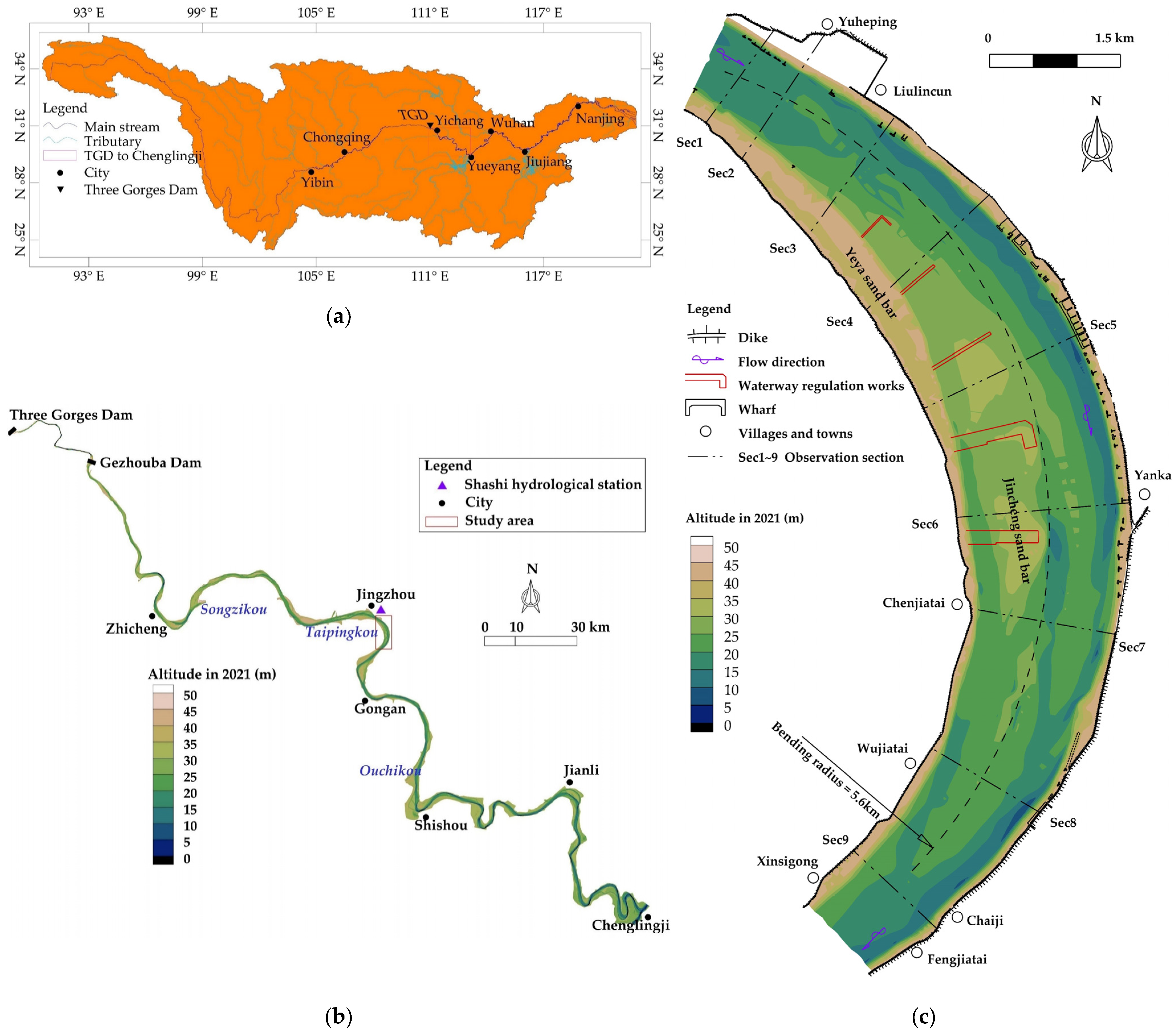
The Wakouzi waterway is located about 190 km downstream of the TGD at the Jingjiang reach in the middle reaches of the Yangtze River and has a sandy riverbed. Jingzhou city, one of the transportation hubs in the middle reaches of the Yangtze River, is located on the left bank of the Wakouzi waterway. Yanka port, an important port in the middle reaches of the Yangtze River, is situated along the left bank. There are many wharves in this port area. The right bank of the waterway is Gongan county. The geographical location of Wakouzi waterway is shown in Figure 1a,b. This waterway starts from Yuheping and ends at Fengjiatai, with a total length of about 11 km. It is a slightly meandering reach with a plane shape of narrow ends and relaxed middle, whose bending radius is about 5.6 km. The Yeya side sand bar and Jincheng center sand bar are distributed in this waterway. The river regime is shown in Figure 1c. In some years, when the Yeya side sand bar on the right bank is connected with the Jincheng central sand bar, a relatively complete convex side sand bar will be formed. At this time, the main stream of the river flows down along the left concave bank.
However, under natural conditions in recent years, the shoal-channel pattern in the river is unstable, making Wakouzi waterway one of the key shoals hindering navigation in the middle reaches of the Yangtze River for a long time. Because the Jincheng sand bar is in the form of the central sand bar, the reciprocating siltation and cutting of the sand bar separates it from the Yeya side sand bar in some years. The river channel constantly branches in the middle and low water with a frequently swinging thalweg, and the main stream swings between the left and right grooves of the central sand bar, resulting in poor navigation conditions on the whole. At the same time, during changes in the Wakouzi waterway, the water depth in the front of Yanka port on the left bank also silted up.
2.2. Data
Affected by human activities, such as soil and water conservation in the upper reaches of the Yangtze River, the sediment yield capacity of the tributaries in the upper reaches of the Yangtze River has reduced since the 1990s [2], and the conditions of water and sediment in the middle reaches of the Yangtze River have changed to some extent. The focus of this study was on the river course evolution and its impact on the waterway conditions in the case that the incoming sediment decreases sharply after the reservoir impoundment. Therefore, this study focused on collecting the relevant data of the studied river reach observed since the 1990s.
The Shashi hydrological station (shown in Figure 1b) is located about 6 km upstream of the study reach. Since 1991, there have been continuous observation data of the daily averaged water level, flow discharge, and sediment concentration, as well as monthly and annual averaged suspended load particle gradation. The above observation data from the Shashi hydrological station since 1991 were collected in this study to analyze the hydrological and sediment changing characteristics of the study reach.
In addition, nine fixed observation sections (shown in Figure 1c) were arranged in the study reach for terrain observation of the riverbed in the form of distance and altitude. In this study, the data of the abovementioned nine sections observed over 25 years since 1991 were collected to analyze the riverbed evolution characteristics. At the same time, topographic mapping was carried out for the study reach every few years. A series of 11 years of survey topographic data were collected in this study.
All observations of the above data were carried out by the Bureau of Hydrology, Changjiang Water Resources Commission. In addition, details of the collected data are shown in Table 1.
2.3. Method
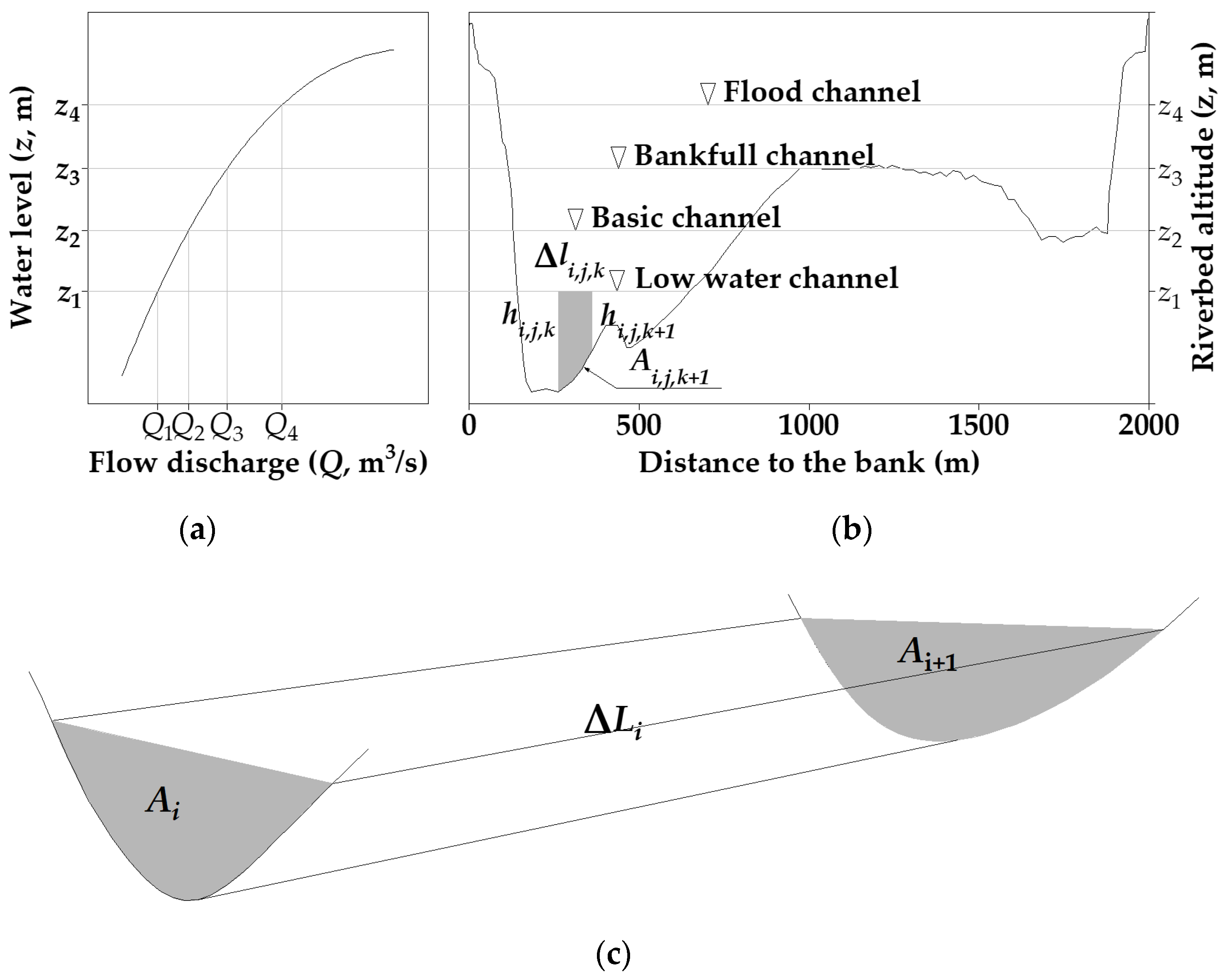
In this study, the calculation of channel erosion and deposition amount was based on the section topography data. First of all, according to the topographic characteristics and the relationship curve between the flow discharge (Q) and the water level (z), four water levels corresponding to the characteristic discharges were selected, under which the channels were named as low water channel, basic channel, bankfull channel, and flood channel, respectively, as shown in Figure 2a,b. According to the section measurement data, the section area under a certain water level could be calculated as follows:
where Ai,j is the area of the jth cross-section in the ith measurement under a certain water level, Δlk is the distance between the kth and k + 1st measuring points on the section, and npt is the number of measuring points.
According to the area of the cross-sections, the channel capacity of a certain measurement time under a certain water level could be calculated. The channel capacity volume, as shown in Figure 2c, was calculated by the prism volume formula:
where Vi is the channel capacity volume under a certain water level in the ith measurement, ΔLj is the distance from the jth section to the j + 1st section, and ncs is the number of sections. According to the difference between the channel capacity volumes of the two adjacent measurements, the amount of erosion and deposition in the time interval between the two measurements could be obtained:
where Wi is the amount of channel erosion and deposition from the ith survey to the I + 1st survey and ny is the number of measurements. When Wi > 0, the riverbed is silted up, and when Wi < 0, the riverbed is scoured.
3. Results
3.1. Hydrological Regimes
3.1.1. Annual Changes
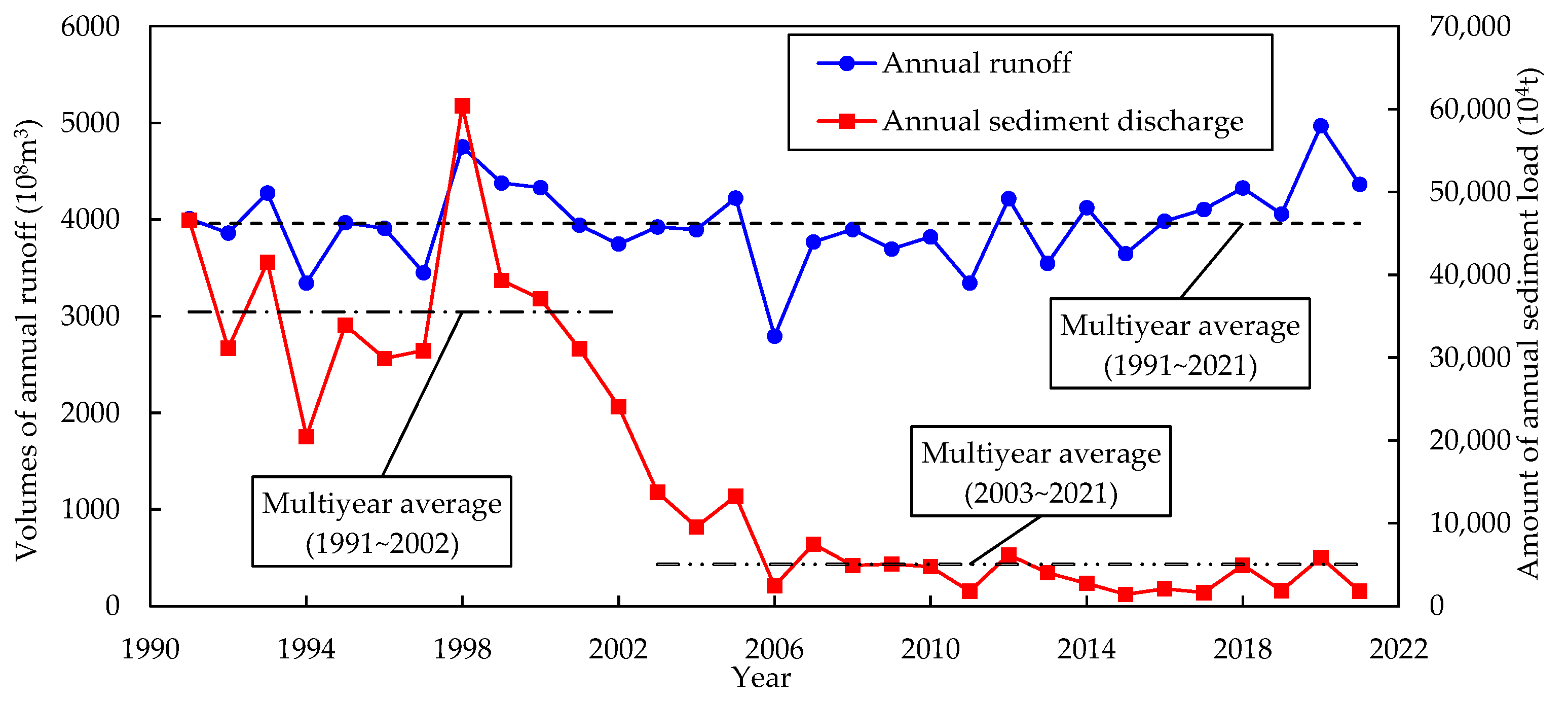
Affected by the impoundment of the reservoir, the hydrology situation downstream of the TGD has been significantly changed, especially the sediment situation. The Wakouzi reach is only about 190 km away from the TGD, and its water and sediment inflow conditions have also been deeply affected. Figure 3 shows the annual runoff and annual sediment discharge of the Shashi hydrological station since 1991. It can be seen from the figure that, except the flood years of 1998 and 2020 and the low flow year of 2006, the interannual fluctuation of the annual runoff of the Shashi hydrological station since 1991 is not large. The multiyear average value is 3957 × 108 m3, and the coefficient of variation is only 0.11.
The interannual variation range of annual sediment discharge is much larger than that of annual runoff. The coefficient of variation is 0.99, about nine times that of annual runoff. Affected by the impoundment of the Three Gorges Reservoir, the annual sediment discharge has sharply decreased since 2003. The multiyear average annual sediment discharge from 1991 to 2002, before the impoundment of the Three Gorges Reservoir, was 35,526 × 104 t. However, it has decreased to only 5038 × 104 t, a decrease of 85.8%, after the impoundment of the Three Gorges Reservoir in 2003. It can also be seen from Figure 3 that the annual sediment discharge of the Wakouzi waterway has shown a very obvious trend of gradual decrease with the increase of storage time of the Three Gorges Reservoir. For example, the multiyear average annual sediment discharge in the three periods of 2003–2005, 2006–2013, and 2014–2021 are 12,193 × 104 t, 4596 × 104 t, and 2797 × 104 t, respectively, showing a very clear decreasing trend. There is an about 100 km-long river section downstream of the TGD with pebble and sand riverbed [36]. With the increase of scouring time since the impoundment of the Three Gorges Reservoir, the riverbed is gradually coarsened and the scouring is gradually weakened. As a result, the sediment supplied from the riverbed decreases, leading to a decreased amount of sediment discharge.
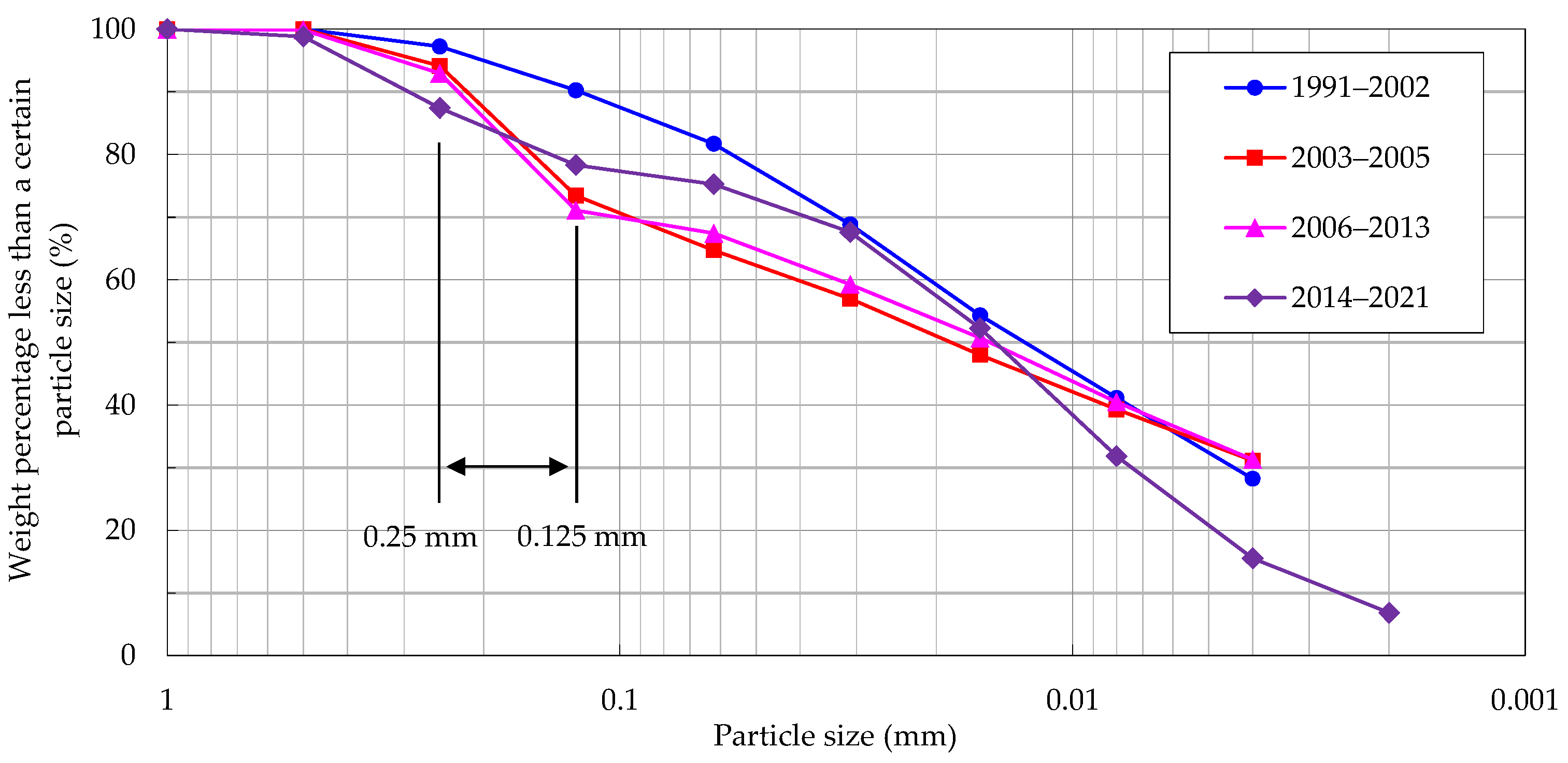
While the annual sediment discharge has significantly decreased, the gradation of the suspended sediment has also changed in different periods, as shown in Figure 4. The suspended sediment content of between 0.125 and 0.25 mm has been most obviously changed. Before the impoundment of the Three Gorges Reservoir, the multiyear average sediment content of this group was about 7%. However, it has benefited from a large amount of riverbed sediment replenishment at the initial stage of impoundment since 2003. From 2003 to 2013, this increased to about 22%. With the completion of scouring of the upper pebble-sandy reach, the riverbed replenishment decreased, and the multiyear average sediment content was also reduced to about 10% from 2014 to 2021.
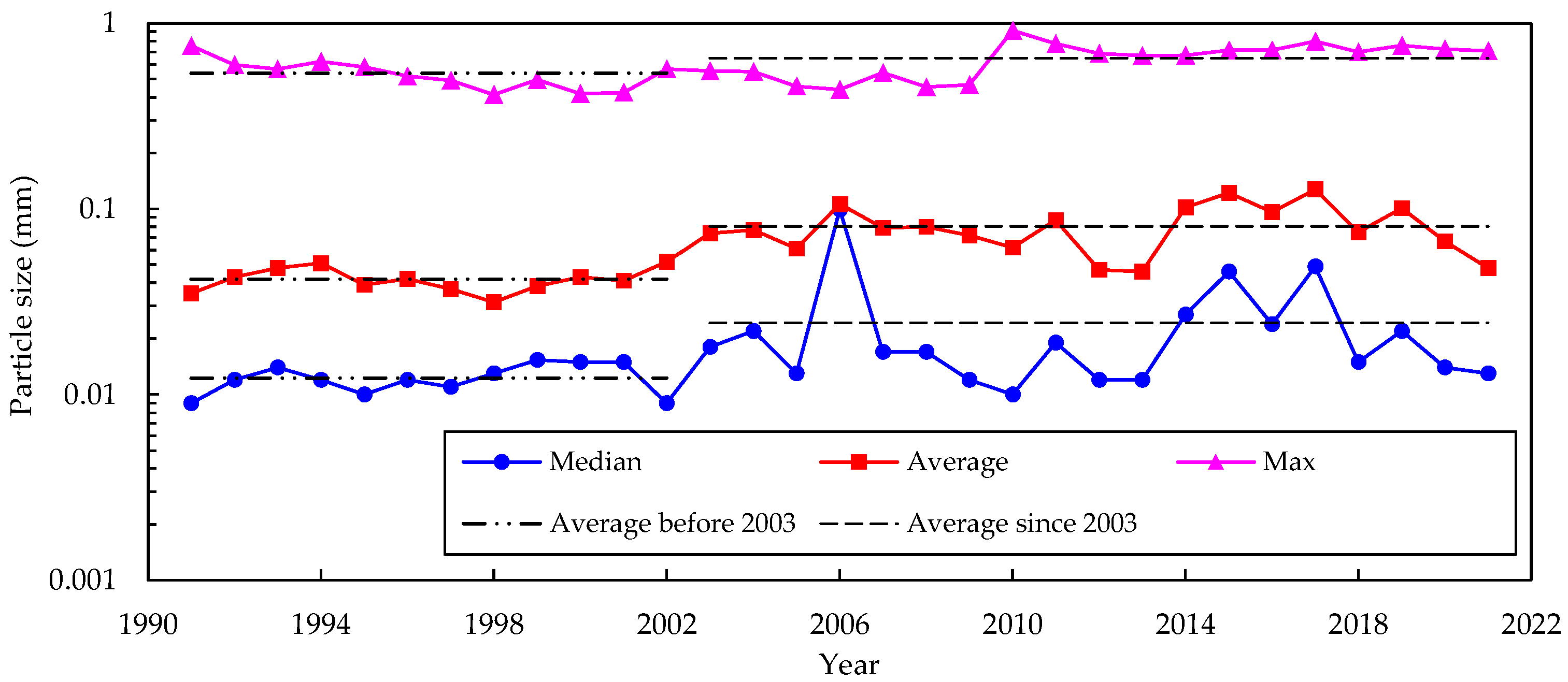
Figure 5 shows the interannual variation of the characteristic particle diameter; namely, median, average, and max particle diameter. It can be seen that the max particle size of the suspended load at Shashi hydrological station has not significantly changed over the years. However, the median and average particle sizes have coarsened from 0.0123 and 0.0432 mm to 0.0243 and 0.0805 mm, respectively. The change range is nearly 100%.
3.1.2. Monthly Distribution
Figure 6a shows the distribution of runoff in different months within the year. It can be seen that the runoff is concentrated in July, August, and September, especially in July, both before and after the impoundment of the Three Gorges Reservoir. Taking the multiyear average situation as an example, the runoff from July to September accounts for 44.6% of the whole year, and that in July accounts for 16.9%, with a coefficient of variation of 0.55.
By comparing before to after the impoundment of the Three Gorges Reservoir, the runoff can be seen to have decreased in July and August during the flood season, while it increased in September after the flood season and from January to April before the flood season after the impoundment of the Three Gorges Reservoir. This is mainly related to the operation of the Three Gorges Reservoir. It always intercepts part of the flood in the flood season to reduce the flood control pressure downstream of the dam. Then, after the flood season, water is stored there for profit. Before the flood season, it must be empty for flood control.
Figure 6b shows the monthly distribution of sediment discharge within the year. It can be seen that although the annual sediment discharge sharply decreased after the impoundment of the Three Gorges Reservoir, the monthly average distribution law did not change, still being concentrated in July–September. Compared with the monthly distribution of runoff, its concentration degree is higher. Taking the situation of the multiyear average as an example, the sediment discharge from July to September accounts for 74.5% of the whole year, and that in July accounts for about 32%. The coefficient of variation reaches 1.32, which is about 2.4 times that of the runoff.
According to the monthly distribution law of the median particle size as shown in Figure 6c, it is largest from March to May before the flood season and smallest from July to September during the flood season. It is the same both before and after the impounding of the Three Gorges Reservoir. The difference is that the median particle size is significantly larger after impoundment, changing from 0.053 to 0.106 mm.
3.1.3. Water Level
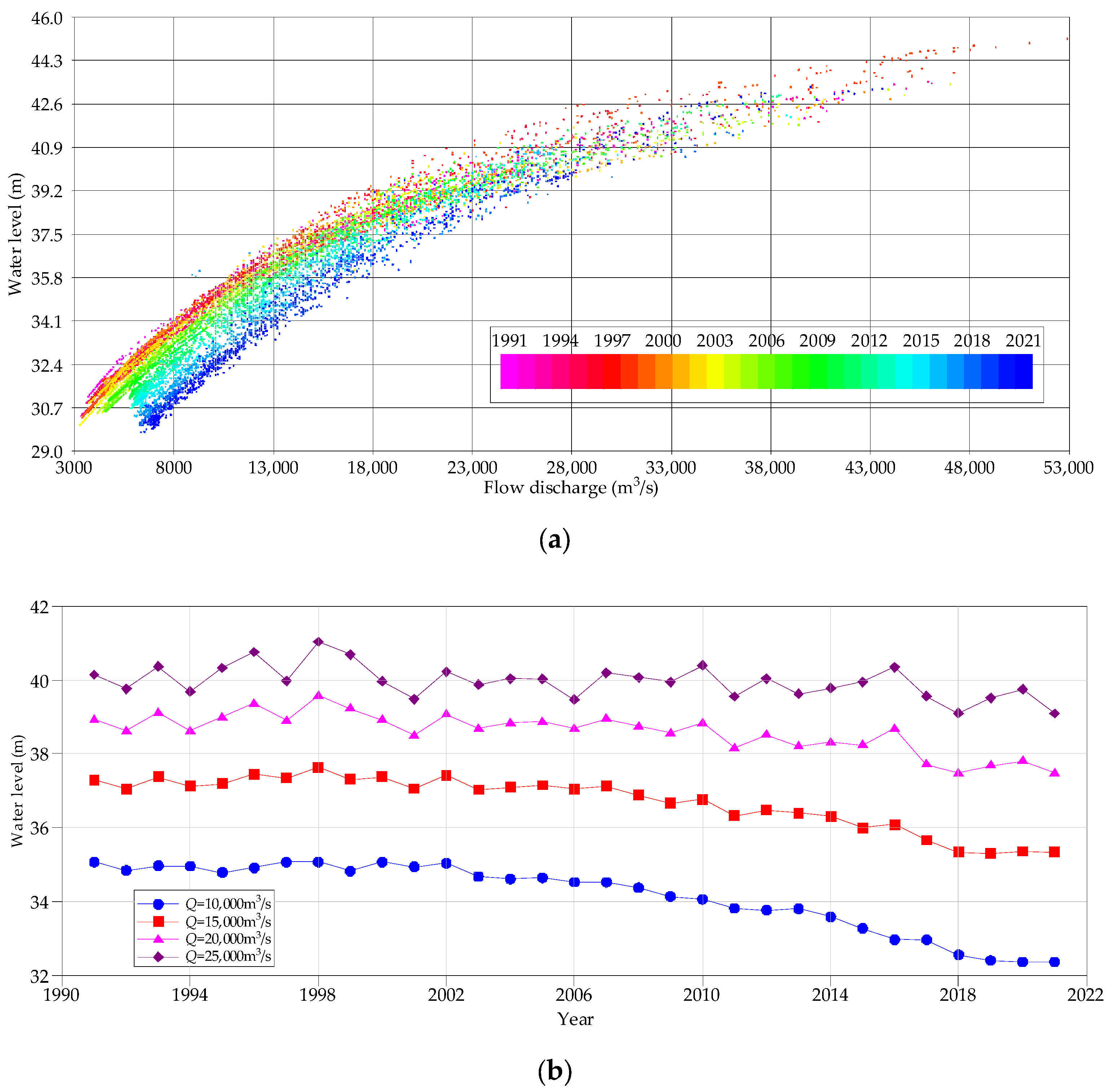
Figure 7a shows the annual change of the relationship between the water level and flow discharge since 1991, and Figure 7b shows the water level corresponding to different flow discharges calculated according to the fitted water level ~ flow discharge relationship curve (cubic polynomial) based on Figure 7a. It can be seen from the Figure 7 that before the impoundment of the Three Gorges Reservoir, the water level changing trend under different flow discharge conditions was not obvious, and there was a small fluctuation between years. The fluctuation range of the water level below 25,000 m3/s was generally within 0.5 m. Comparing the water level in 2002 with that in 1991, when the flow discharge was 10,000, 15,000, 20,000, and 25,000 m3/s, the water level changes were −0.04, 0.12, 0.14, and 0.08 m, respectively. After the impoundment of the Three Gorges reservoir, the water level of Shashi station began to show an obvious continuous downward trend, and the smaller the flow discharge was, the more obvious the water level drop was. When the flow discharge was 10,000 m3/s, the water level decline rate was relatively slow from 2003 to 2008, with a cumulative drop of 0.31 m and an annual decline of about 0.06 m. From 2009 to 2018, the water level decline rate began to accelerate. The cumulative water level drop was 1.81 m in this period, meaning an annual decline of 0.18 m, about three times that of the previous 5 years. After 2018, the water level declined slowly, and the cumulative water level drop was 0.2 m; in other words, an annual decline of only 0.06 m. With the increase of flow discharge, the law of water level change was also different. When the flow was 25,000 m3/s, the water level was basically the same from 2004 to 2016, with an average value of 39.95 m; however, it decreased after 2016. The average value was about 39.40 m from 2017 to 2021, meaning a cumulative decrease value of 0.55 m.
3.2. River Geomorphology
3.2.1. Amount of Erosion and Deposition
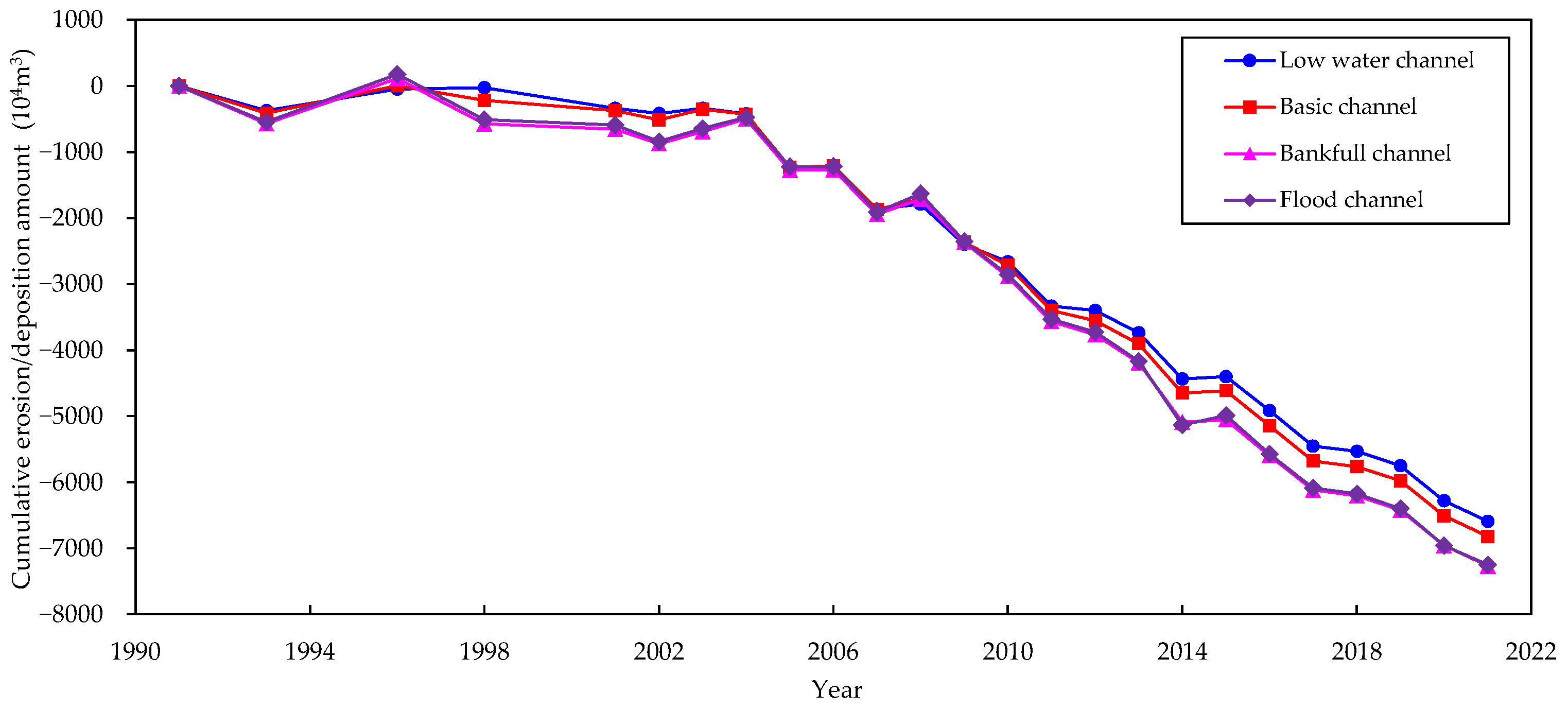
Figure 8 shows the cumulative erosion and deposition amount of Wakouzi channel since the 1990s and Table 2 provides the values for different periods. It can be seen from Figure 8 and Table 2 that before 1996, the studied river section maintained the balance of erosion and deposition. From 1991 to 1996, the low water channel was only scoured by 47 × 104 m3, and the multiyear averaged annual scouring amount was only 9.4 × 10⁴ m3. The basic channel, bankfull channel, and flood channel were slightly silted, of which the flood channel had the largest siltation amount of 174 × 104 m3, meaning an annual siltation intensity of only 34.8 × 10⁴ m3. From 1996 to 2004, the different channels all showed a cumulative scouring state, and the annual scouring volume of each type of channel was 47 × 104 m3 to 82 × 104 m3. Since 2004, the impact of the impoundment of the Three Gorges Reservoir began to appear in this reach, bringing the river section into an obvious scouring state. By comparing the scouring and silting amount of different types of channels, it was found that the scouring amount gradually increases from the low water channel to the flood channel, indicating that scouring occurs not only in the low water channel but also in the flooded sand bar when the water level is high. From the perspective of scour intensity, the multiyear annual scouring intensity of the low water channel from 2004 to 2013 was 368 × 104 m3, about eight times that of 1996 to 2004. The yearly scouring intensity of the flood channel reached about 410 × 104 m3. After 2013, the reach basically maintained the same scouring intensity as the previous 10 years, keeping it in a continuous scouring state. Overall, the total scouring volume from 2004 to 2021 was about 6175 × 104 to 6771 × 104 m3 from the low water channel to the flood channel, meaning an average annual scouring intensity of 363 × 104 to 398 × 104 m3. At the same time, according to the scouring amount of different river channels, scouring has mainly occurred in the low water channel, accounting for about 91.2% of the total scouring amount.
3.2.2. Distribution of Erosion and Deposition
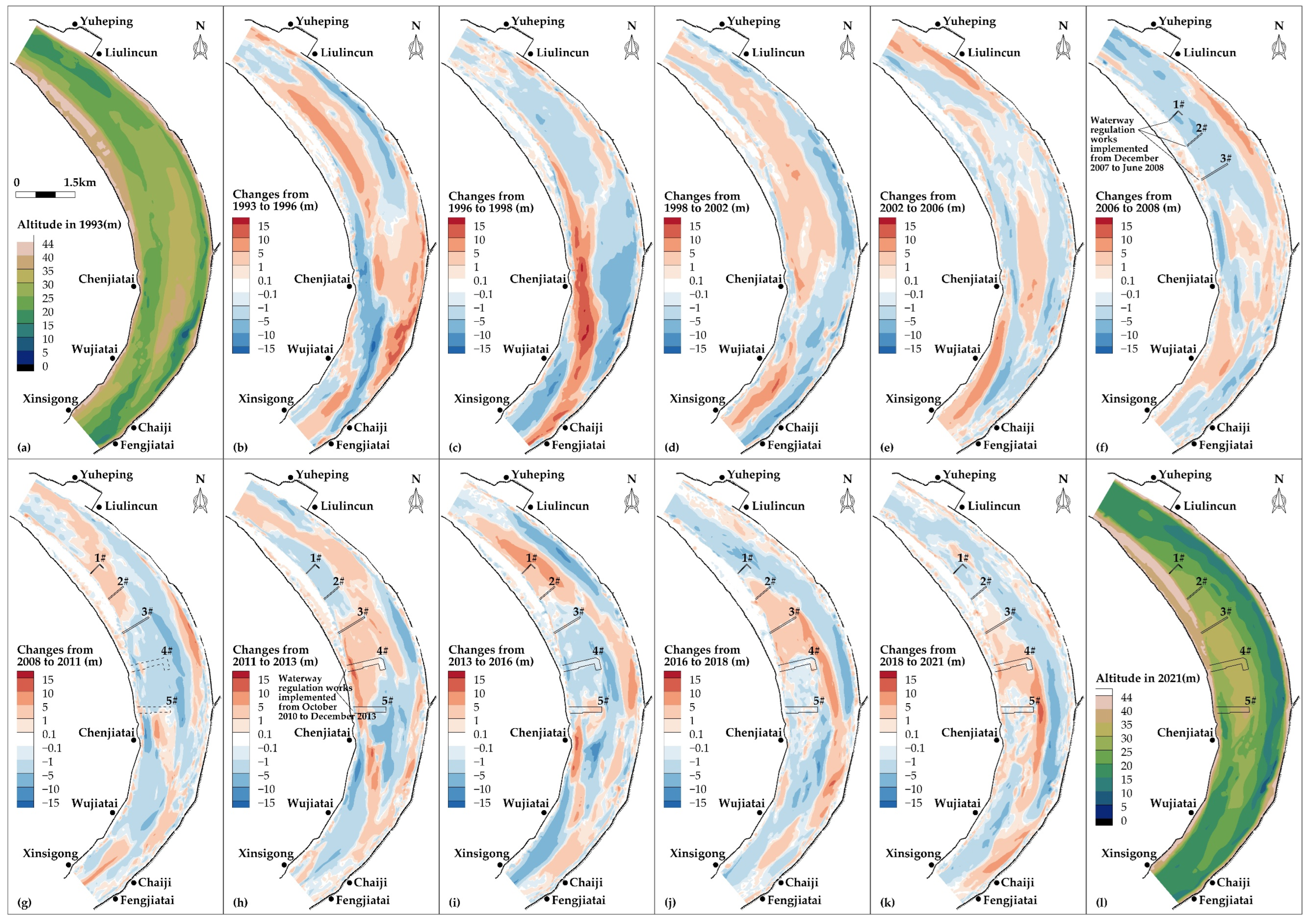
The erosion and deposition distribution of the Wakouzi waterway since 1993 is shown in Figure 9. It can be seen that the studied river section has been controlled by the geological conditions on both banks and the artificial bank protection. The plane shape is basically stable, and the branching and micro bend shape has been maintained. The evolution of the river channel is mainly manifested by the frequent erosion and deposition of the sand bar in the river.
Before the impoundment of the Three Gorges Reservoir, the reach basically presented the characteristics of interannual erosion and deposition, and there had been no obvious trend of erosion or deposition among the years. For example, the upper reaches of the Jincheng sand bar were silted from 1993 to 1996 as shown in Figure 9b, with the siltation amplitude generally ranging from 1 to 5 m, locally reaching about 5 to 10 m. From 1996 to 1998, it was scoured with the scouring amplitude generally ranging from 1 to 5 m (Figure 9c). After that, from 1998 to 2002, it was silted again, as shown in Figure 9d. The other regions in this reach showed a similar evolution law. For example, the lower reaches of the Jincheng sand bar showed scouring from 1993 to 1996 (Figure 9b), but silting from 1996 to 1998 (Figure 9c), and again scouring from 1998 to 2002 (Figure 9d).
After the impoundment of the Three Gorges Reservoir, the income sediment decreased. From 2002 to 2008, as shown in Figure 9e,f, the upper reaches of the Jincheng sand bar continued to be scoured and shrank, and the deep channel of the left branch was silted up with a siltation range of 2 to 5 m, resulting in a decrease in the water depth in the navigation channel of the left branch and a deterioration in navigation conditions.
Since 2008, a series of waterway regulation works have been implemented in this reach, and the evolution of the riverbed has started to be affected by the regulation projects. In order to suppress the unfavorable development of navigation conditions, the first phase waterway regulation works were implemented from December 2007 to June 2008, including 1#~3# sand bar protection belt projects. After implementation of the projects, from 2008 to 2011, as shown in Figure 9g, the siltation occurred in the upstream area of the sand bar protection belt projects, and the left branch navigation channel outside the sand bar protection belt projects was scoured and cut down, leading to improved navigation conditions. However, the central part of the Jincheng sand bar body below the 3# belt began to be scoured, and the surface at the tail sand bar was further silted up. At the same time, the lower section of the right branch began to be in an upward scouring state. The above evolutions led to the dispersion of water flow with a silted up left branch in this area. As a result, the navigation conditions in the area below the 3# belt began to develop unfavorably.
In order to further suppress the unfavorable development of the navigation conditions in the area below the 3# belt, the second phase waterway regulation works were implemented from October 2010 to December 2013, and the 4# and 5# sand bar protection belt projects were constructed. After the implementation of the two-phased projects, siltation occurred in the 4# and 5# belts zone from 2011 to 2013 (Figure 9h).
After 2013, the Jincheng sand bar was cut by the flood plain flow, and the sand bar tail was scoured and cut into an independent island. The lower section of the right channel continued to develop in the form of upward scouring. From 2013 to 2018, the sand bar body above the 4# belt was basically silted, while the head and the downstream of the 5# belt changed greatly from year to year by developing a series of gullies on the sand bar surface as shown in Figure 9i,j. From 2018 to 2021, the 4# belt zone was slightly silted, while the 5# belt zone was in a continuous scouring state (Figure 9k).
According to the recent topography, as shown in Figure 9l, the zone near the five built sand bar protection belts presents a complete sand bar body, but the tail of the Jincheng sand bar is cut by a series of ditches, and the scouring at the tail of the right channel is still upward developing.
3.2.3. Role of Channel Regulation Works in River Course Evolution
By judging the river course of Wakouzi reach, it can be seen that the evolution is obviously affected by the implementation of channel regulation works. The implementation of local protection works has protected the sand bar where the project is located. For example, after the implementation of the first and second phase works (1#~5# sand bar protection belts), the sand bar body above the projects, as well as the protection area and the Yeya sand bar area, had been deposited. The siltation of the local area where the regulation works is located maintains the integrity of the sand bar, makes the water flow tend to concentrate, and curbs the swing of the channel. However, it is worth pointing out that the unguarded area is still continuously scoured by the clean water flow, resulting in the shrinkage of local bar bodies, thus dispersing the local water flow and seriously threatening the navigation safety.
4. Discussion
4.1. Response of Erosion and Deposition to Water and Sediment Conditions
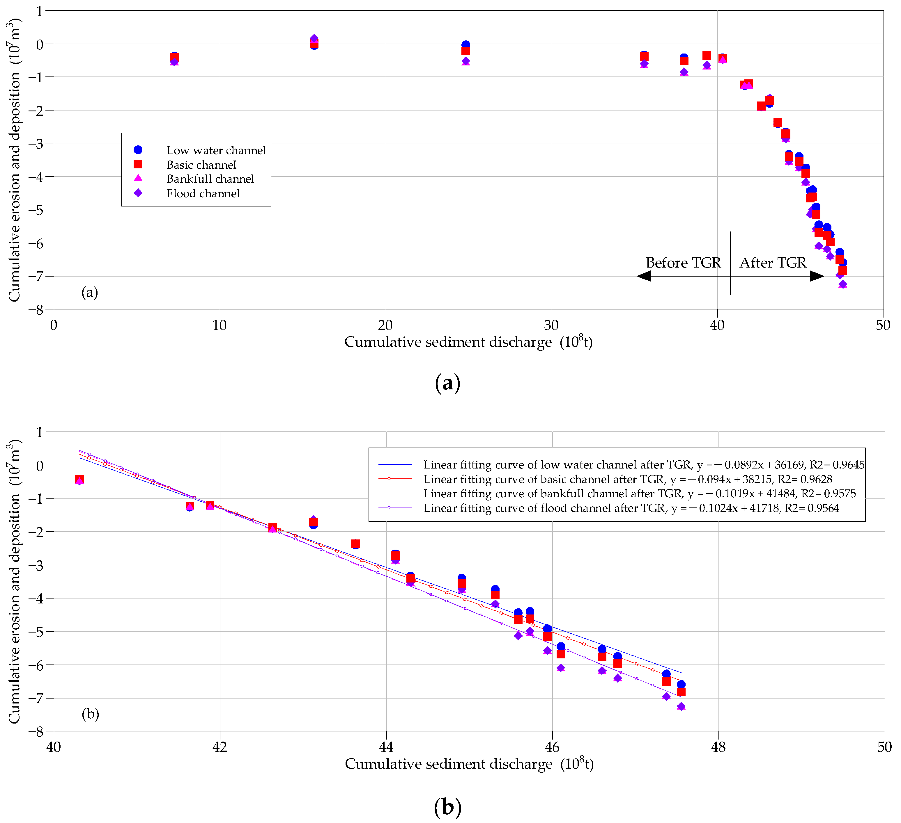
The river evolution is closely related to the water and sediment conditions. Their changes, especially those caused by the construction of the water conservancy project, cause a series of corresponding erosions and depositions at the downstream riverbed, which is quite common in rivers, such as the Yellow River [37,38], Yangtze River [6,7,11,39,40], and Pearl River [41]. Although the evolution of the sand bar is also affected by human activities and the linkage of the upper and lower reaches [42], it is most closely related to the conditions of incoming water and sediment. Figure 10 shows the relationship between the cumulative sediment discharge and cumulative erosion and deposition amount in the Wakouzi reach. Before the impoundment of the Three Gorges Reservoir, the river section was in a state of alternating erosion and siltation, and there was no obvious trend between years. The correlation between the accumulated sediment discharge and the accumulated erosion and siltation was not obvious in the natural state, as shown in Figure 10a.
However, this situation significantly changed after the impoundment of the Three Gorges Reservoir. There is a clear linear correlation between the accumulated sediment discharge and the accumulated erosion and deposition (Figure 10b). The correlation coefficient (R2) of the linear fitting curve of different river channels is above 0.95. It can also be seen from Figure 10 that with the increase of water level, the correlation between the accumulated erosion and deposition and the accumulated sediment discharge decreases slightly from the low water channel to the flood channel with the R2 changing from 0.9645 to 0.9564. This is closely related to the characteristics of water and sediment movement in the meandering reach. This study shows that the upstream inflow is the main factor affecting the water level velocity of the sand bar, while the upstream sediment recharge is the secondary factor [43].
In the future, with the completion and operation of the cascade reservoirs in the upper reaches of the Yangtze River, the outflow flow of the Three Gorges Reservoir will maintain a very low sediment concentration for a long time. In addition, the riverbed of Wakouzi reach is mainly composed of fine sand. With the passage of time, the scouring state of the study river section may not end in a short time [44], and will be continuously scoured in the future.
4.2. Response of Water Level Change to Riverbed Evolution
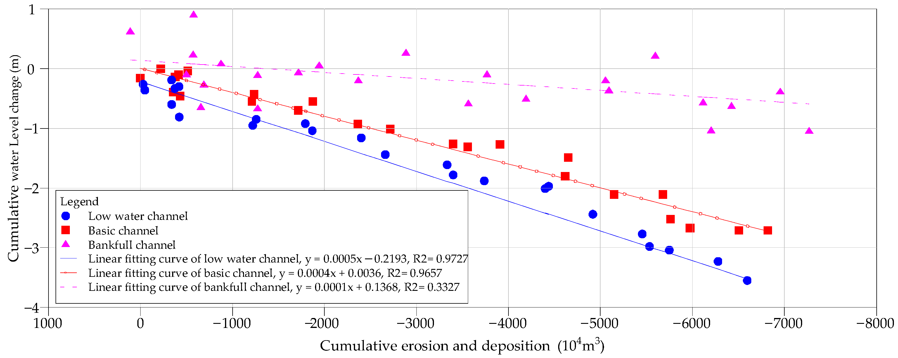
Accompanied by the adjustment of the riverbed, the water level under the same flow discharge inevitably changes for the river channel. This correlation has been verified in a large range of river sections downstream of the Three Gorges Reservoir [45,46]. Figure 11 shows the relationship between the cumulative water level change of the Wakouzi waterway and the cumulative scouring and deposition amount. As shown in Figure 11, for the low water channel and the basic channel, there is an obvious linear correlation between cumulative water level change and cumulative erosion and deposition amount, and the correlation coefficient (R2) is generally above 0.96. This is different from the abovementioned correlation between the accumulated scouring and deposition and the accumulated sediment discharge. However, the relationship between the cumulative erosion and deposition of the bankfull channel and the cumulative water level change is obviously scattered, and the correlation coefficient (R2) is only 0.33. This indicates that, in addition to the erosion and deposition of the riverbed, the water level change for the bankfull discharge may be related to many other factors.
Considering that the riverbed will maintain the trend of scouring and cutting down for a long time into the future, as discussed in this study, the low water level of the Wakouzi section is likely to continue to decline.
4.3. Influence on Waterway Conditions and Countermeasures
4.3.1. Influence on Waterway Conditions
The waterway conditions are closely related to the shape of the sand bar and the deep groove under the medium and low water conditions. Because the Wakouzi reach is a slightly curved river with narrow ends and relaxed middle, under natural conditions, especially after the impoundment of the Three Gorges Reservoir, the riverbed scour and undercutting are obvious, and the sand bar groove pattern is very unstable. In the middle and upper section, the Jincheng sand bar body is low and easy to wash back. At the same time, the underwater sand ridges are relatively developed in this area, which leads to an unfavorable situation wherein sand ridges squeeze the navigation channel and cause insufficient navigation width after a large water year. In the lower section, the sand bar scouring, groove siltation, upward development of the right groove, and insufficient width of the left channel all cause the navigation conditions of the left channel to be in a continued deteriorating state. In addition, the continuous decline of the low water level causes the shortage of water depth in the transition shoal section in the low water period, which reduces the navigation time of the channel, resulting in a lower navigation guarantee rate and a declined waterway grade.
After the first and second phase implementation of waterway regulation works, the Jincheng sand bar body upstream of the 5# shoal protection belt and upstream of the right bank side were silted up, and the development of the middle and upper sections of the right channel were restricted. As a result, the low head of the Jincheng sand bar was gradually stabilized. This change is conducive to maintaining a favorable waterway pattern with a deep groove at the left bank side and a side sand bar at the right bank. Moreover, the navigation conditions were obviously improved. However, under the continuous impact of the impoundment of the Three Gorges Reservoir with a continuous unsaturated water flow, the unprotected area in the lower section of the Jincheng sand bar continues to be scoured and shrunk. The area of the sand bar body downstream of the built belts is greatly reduced. At the same time, the lower section of the right groove continues to be upward developed, and the middle and lower section of the left groove have begun to be deposited. Affected by the above factors, some shallow areas have begun to appear in the relaxed section of the left groove, which is not conducive to the maintenance of the navigation conditions of the left channel. In the future, with continuous scouring, the unprotected surface of the lower section of the Jincheng sand bar will continue to be scoured. The ditch on the sand bar surface and the upward scouring of the lower section of the right channel will threaten navigation safety in the Wakouzi waterway.
4.3.2. Countermeasures
For the meandering reach, the water regulation idea is to control the channel boundary and suppress the riverbed scouring on the convex bank side of the curve to increase the scouring capacity of the water flow in the main channel, limiting the diffusion of medium and low water flow to the convex bank side, and maintaining the existing good channel conditions [47]. The critical problem of the Wakouzi waterway lies in the fact that the key sand bar shoreline in this reach has not been effectively controlled, and the mainstream still has a large swing space in the relaxed section. The navigation conditions of the main branch tend to develop in an unfavorable direction. After the implementation of the waterway regulation works, the development of an unfavorable trend has been restrained to a certain extent. However, the control of the Jincheng sand bar and the right groove in the advanced waterway regulation works is insufficient in both scope and strength, resulting in an unstable sand bar type in the downstream of the control range of the sand bar protection projects, and the navigation conditions tend to develop in an unfavorable direction. Therefore, countermeasures for the Wakouzi waterway can be determined to further protect the middle and lower section of the Jincheng sand bar, and form a slightly curved river regime with the sand bar body on the right and the navigation channel on the left.
Judging from the current sandy river bed evolution of the middle and lower reaches of the Yangtze River, even the Jingjiang reach, which is closest to the TGD and where the study reach is located, has not weakened in recent years, and erosion is gradually occurring in the lower reaches with a significantly increased erosion intensity extended to the estuary [35]. In the future, it may take decades for the reach below Chenglingji in the middle reaches of the Yangtze River to establish a new geomorphic dynamic balance [44]. This shows that although the current impact of the TGD on the downstream river reach may vary with the distance, the sandy river reach further away from the dam may also face the same scouring situation as the studied reach in the future. The results of this study on the hydro-morphodynamic evolution and impact on waterway navigation are a useful reference for the other meander bend river reaches in the middle and lower Yangtze River.
5. Conclusions
- (1)
- Although the operation of the Three Gorges Reservoir has no obvious impact on the annual runoff and monthly distribution in the Wakouzi waterway, the annual suspended sediment discharge has significantly decreased by 85.8%, and the median and average sediment particle size has almost doubled. At the same time, the low water level has dropped significantly, and began to accelerate in the fifth year after the impoundment of the Three Gorges Reservoir. With the increase of flow discharge, the water level drop shows a downward trend. The cumulative water level drop under the flow discharge of 10,000 m3/s is about 2.32 m, while it is 0.78 m under 25,000 m3/s.
- (2)
- Affected by the sharp decrease of sediment transport after the impoundment of the Three Gorges Reservoir, the Wakouzi reach has been continuously scoured since 2004. By 2021, the accumulated scour of the flood channel was 6771 × 104 m3, with an annual scour intensity of about 398 × 104 m3. The scouring mainly occurs in low water channels, accounting for about 91.2%. The sand bars in the channel continue to be eroded and shrunk, and the local waterway regulation, consisting of five protection belts in the middle and upper areas of the sand bar, has not prevented flood water from cutting the unguarded area, and the surface of the sand bar has developed into a series of ditches, while the tail of the sand bar is upward scoured.
- (3)
- Since the impoundment of the Three Gorges Reservoir, there has been good correlation between the accumulated scouring amount and the accumulated sediment discharge, as well as the accumulated water level drop. Therefore, considering the long-time clean water discharge of the Three Gorges Reservoir and sandy river bed, the Wakouzi waterway will be continuously scoured in the future, and the low water level may have a further drop.
- (4)
- Both the erosion and retreat of the sand bar and the decline of the low water level are unfavorable to the waterway conditions. Although the implemented partial waterway regulation works can maintain the integrity of the sand bar in the project area, the unguarded area will still evolve in an unfavorable trend for the waterway conditions. Therefore, for the meandering sandy reach at the downstream of a reservoir, a series of waterway regulation works aimed at guarding all the sand bars should be implemented to maintain better waterway conditions. This can provide a meaningful reference for the formulation of waterway regulation works in other similar river reaches.
Author Contributions
Conceptualization, H.G. and L.Z.; methodology, H.G.; validation, H.G., L.Z. and C.D.; formal analysis, H.G., L.Z. and L.J.; investigation, H.G.; resources, H.G. and L.Z.; data curation, L.Z.; writing—original draft preparation, H.G. and L.Z.; writing—review and editing, H.G. and L.Z.; visualization, C.D. and R.L.; supervision, H.G.; project administration, H.G.; funding acquisition, H.G. All authors have read and agreed to the published version of the manuscript.
Funding
This research was funded by the National Natural Science Foundation of China, grant numbers U2240224 and U2240206, Major Scientific and Technological Projects of the Ministry of Water Resources, grant number SKR-2022009, and the Overall Planning Project for Succeeding Work of the Three Gorges Project, grant number CKSG2021257/HL.
Data Availability Statement
Not applicable.
Acknowledgments
This research was supported by the Research and Innovation Team of River and Lake Protection and Regulation in the Middle and Lower Reaches of the Yangtze River led by Yao Shiming.
Conflicts of Interest
The authors declare no conflict of interest.
References
- Peng, W.; Shuai, C.F.; Xin, X. Yangtze River: China’s golden waterway. Proc. Inst. Civ. Eng.-Civ. Eng. 2010, 163, 15–18. [Google Scholar] [CrossRef]
- Wang, Y.G.; Hu, C.H.; Liu, X.; Shi, H.L. Study on variations of runoff and sediment load in the Upper Yangtze River and main Influence factors. J. Sediment Res. 2016, 1–8. [Google Scholar] [CrossRef]
- Yang, Y.P.; Zhang, M.J.; Zhu, L.L.; Liu, W.L.; Han, J.Q.; Yang, Y.H. Influence of Large Reservoir Operation on Water-Levels and Flows in Reaches below Dam: Case Study of the Three Gorges Reservoir. Sci. Rep. 2017, 7, 14. [Google Scholar] [CrossRef] [Green Version]
- Liu, S.W.; Zhang, X.F.; Xu, Q.X.; Yue, Y. Transport characteristics and contributing factors of suspended sediment in Jinsha River in recent 50 years. J. Sediment Res. 2020, 45, 30–37. [Google Scholar] [CrossRef]
- Guo, W.X.; Dou, G.F.; Wang, H.X.; Li, Y. Quantitative Evaluation of the Impact of Precipitation and Human Activities on Sediment Regime in the Middle and Lower Reaches of the Yangtze River in Recent Sixty Years. J. Basic Sci. Eng. 2021, 29, 39–54. [Google Scholar] [CrossRef]
- Li, D.F.; Lu, X.X.; Chen, L.; Wasson, R.J. Downstream geomorphic impact of the Three Gorges Dam: With special reference to the channel bars in the Middle Yangtze River. Earth Surf. Process. Landf. 2019, 44, 2660–2670. [Google Scholar] [CrossRef]
- Yang, Y.P.; Zheng, J.H.; Zhang, H.Q.; Chai, Y.F.; Zhu, Y.D.; Wang, C.Y. Impact of the Three Gorges Dam on riverbed scour and siltation of the middle reaches of the Yangtze River. Earth Surf. Process. Landf. 2022, 47, 1514–1531. [Google Scholar] [CrossRef]
- Mei, X.F.; Dai, Z.J.; van Gelder, P.; Gao, J.J. Linking Three Gorges Dam and downstream hydrological regimes along the Yangtze River, China. Earth Space Sci. 2015, 2, 94–106. [Google Scholar] [CrossRef]
- Jiang, L.Z.; Ban, X.; Wang, X.L.; Cai, X.B. Assessment of Hydrologic Alterations Caused by the Three Gorges Dam in the Middle and Lower Reaches of Yangtze River, China. Water 2014, 6, 1419–1434. [Google Scholar] [CrossRef] [Green Version]
- Zhang, J.H.; Feng, L.J.; Chen, S.J.; Huang, T.; Chen, L.; Wang, D.W.; Dai, M.L.; Zhang, D.D. Impoundment Impact of the Three Gorge Reservoir on the Hydrological Regime in the Lower Han River, China. Water 2018, 10, 1670. [Google Scholar] [CrossRef]
- Zhang, W.; Yuan, J.; Han, J.Q.; Huang, C.T.; Li, M. Impact of the Three Gorges Dam on sediment deposition and erosion in the middle Yangtze River: A case study of the Shashi Reach. Hydrol. Res. 2016, 47, 175–186. [Google Scholar] [CrossRef] [Green Version]
- Yang, Y.P.; Zheng, J.H.; Zhang, M.J.; Zhu, L.L.; Zhu, Y.D.; Wang, J.J.; Zhao, W.Y. Sandy riverbed shoal under anthropogenic activities: The sandy reach of the Yangtze River, China. J. Hydrol. 2021, 603, 17. [Google Scholar] [CrossRef]
- Yin, Z.; Zhang, H.B.; Tan, G.M.; Lyu, Y.W.; Feng, Z.Y.; Shu, C.W.; Wang, J.W.; Zhang, G.Y. Operating Effects of the Three Gorges Reservoir on the Riverbed Stability in the Wuhan Reach of the Yangtze River. Water 2021, 13, 3353. [Google Scholar] [CrossRef]
- Yang, Y.P.; Zhang, M.J.; Liu, W.L.; Wang, J.J.; Li, X.X. Relationship between Waterway Depth and Low-Flow Water Levels in Reaches below the Three Gorges Dam. J. Waterw. Port Coast. Ocean Eng. 2019, 145, 10. [Google Scholar] [CrossRef]
- Tian, J.X.; Chang, J.; Zhang, Z.X.; Wang, Y.J.; Wu, Y.F.; Jiang, T. Influence of Three Gorges Dam on Downstream Low Flow. Water 2019, 11, 65. [Google Scholar] [CrossRef] [Green Version]
- Chen, X.Y.; Gao, K.C. Effects of the Three Gorges Project on the mainstream waterway of the Yangtze River and their improvement measures. In Proceedings of the 9th International Symposium on River Sedimentation, Yichang, China, 18–21 October 2004; pp. 189–194. [Google Scholar]
- Xia, J.Q.; Liu, X.; Yao, J.Z.; Zhou, M.R.; Deng, S.S. Low-water channel adjustment in middle Yangtze River after operation of Three Gorges Project and its effect on navigation. J. Hydroelectr. Eng. 2021, 40, 1–11. [Google Scholar] [CrossRef]
- Yan, T.; Yang, Y.P.; Li, Y.B.; Chai, Y.F.; Cheng, X.B. Possibilities and challenges of expanding dimensions of waterway downstream of Three Gorges Dam. Water Sci. Eng. 2019, 12, 136–144. [Google Scholar] [CrossRef]
- Li, W.J.; Wang, D.W.; Yang, S.F.; Yang, W. Three Gorges Project: Benefits and challenges for shipping development in the upper Yangtze River. Int. J. Water Resour. Dev. 2021, 37, 758–771. [Google Scholar] [CrossRef]
- Zhou, M.R.; Xia, J.Q.; Lin, F.F.; Deng, S.S. Adjustments in Low-water Channel Geometry and Its Effect on the Navigation Condition of the Upper Jingjiang Reach After the Three Gorges Project Operation. Adv. Eng. Sci. 2017, 49, 74–82. [Google Scholar] [CrossRef]
- Liu, H.H.; Yin, S.R. Sediment problems and regulation technology progress of Changjiang waterway. Yangtze River 2018, 49, 18–24, 45. [Google Scholar] [CrossRef]
- Li, M.; Hu, C.H.; Zhou, C.C.; Peng, S.B. Analysis on the Evolution mechanism of the “steep slope and rapid flow” section of Lujia waterway in the middle reaches of the Yangtze River under new conditions of water and sediment. J. Hydraul. Eng. 2021, 52, 158–168. [Google Scholar] [CrossRef]
- Liu, H.H.; Mao, C.S.; He, M.X. Study on channel changes and regulation countermeasures in a shoaly sand-cobble bed reach below the Three Gorges Project. In Proceedings of the 9th International Symposium on River Sedimentation, Yichang, China, 18–21 October 2004; pp. 701–705. [Google Scholar]
- Li, M. Water lever changing law in dry season and its effects on navigation in the middle Yangtze River. Port Waterw. Eng. 2017, 156–160. [Google Scholar] [CrossRef]
- Lin, F.F.; Xia, J.Q.; Zhou, M.R.; Deng, S.S. Influence of boundary conditions on low-water channel geometry adjustments of Jianli Section, Jingjiang Reach of Changjiang River. Yangtze River 2021, 52, 1–8, 35. [Google Scholar] [CrossRef]
- Zhao, Z.C.; Yao, S.M.; Tang, F.; Qu, G. Evolution law and trend of river bed in Xiongjiazhou to Chenglingji reach under erosion condition. Port Waterw. Eng. 2019, 134–140. [Google Scholar] [CrossRef]
- Xia, J.Q.; Lin, F.F.; Zhou, M.R.; Yao, J.Z. Recent Morphodynamic Evolution of the Jiepai Reach and Its Effect on the Navigation Condition. J. Basic Sci. Eng. 2020, 28, 27–39. [Google Scholar] [CrossRef]
- Yang, Y.P.; Liu, W.L.; Zhang, J.; Yang, L.J.; Jia, M.L.; Zhu, L.L. Changes of Divergence and Confluence Relationship Between Dongting Lake and the Yangtze River After the Operation of the Three Gorges Project and Its Impact on the Waterway Depth. Front. Earth Sci. 2022, 10, 16. [Google Scholar] [CrossRef]
- Ye, Z.W. Analysis of evolution trend of Dongbei waterway in middle reach of the Yangtze River under new water and sediment conditions. Port Waterw. Eng. 2019, 141–147. [Google Scholar] [CrossRef]
- Liu, X.Q.; Yang, Y.H.; Zhang, M.J. Adaptability of regulation projects in Jingjiang navigation-obstructing sections to Three Gorges reservoir impounding. J. Hydroelectr. Eng. 2017, 36, 16–25. [Google Scholar] [CrossRef]
- Yang, X.H.; Xiong, H.B.; Li, Y.T.; Li, S.X. Adjustment mechanism of the typical sandbars in the lower Jingjiang River after the im-poundment of the Three Gorges Reservoir. J. Lake Sci. 2021, 33, 819–829. [Google Scholar] [CrossRef]
- Ye, Z.W.; Liu, Y.J.; Du, Y. Regulation measures for 6 m-depth Daijiazhou waterway in middle reach of the Yangtze River under new water and sediment conditions. Port Waterw. Eng. 2021, 116–122, 133. [Google Scholar] [CrossRef]
- Chen, Y.J.; Jiang, L. Evaluation of waterway engineering construction and regulation effect in middle and lower reaches of the Yangtze River. Port Waterw. Eng. 2019, 6–11, 34. [Google Scholar] [CrossRef]
- Yang, Y.P.; Li, M.; Liu, W.L.; Zhu, Y.D.; Yang, L.J.; Yu, W.J. Study on the relationship between beach trough evolution and navigation obstruction characteristics in Jingjiang reach of the Yangtze River. Adv. Water Sci. 2022, 33, 240–252. [Google Scholar] [CrossRef]
- Xu, Q.X.; Dong, B.J.; Zhang, W. Characteristics and analysis on scouring and silting changes in main stream of middle and lower reaches of Changjiang River in 2020. Yangtze River 2021, 52, 1–8. [Google Scholar] [CrossRef]
- Xiong, H.; Sun, Z.; Li, M.; Chen, L. Causes of local gravel deposition in gravel-sand transition of the Middle Yangtze River under clear water scour. Adv. Water Sci. 2020, 31, 524–534. [Google Scholar] [CrossRef]
- Yang, X.Y.; Hu, H.H.; Zhang, Z.H.; Liu, C.H. Relationships of floodplain and main channel processes and flow and sediment in the Lower Yellow River. J. Sediment Res. 2020, 45, 16–20. [Google Scholar] [CrossRef]
- Liu, Q.L.; Chen, J.Q.; Chen, S.L. Spatiotemporal evolution of Yellow River estuarine channel and its influencing factors since the water-sediment regulation scheme. Acta Geogr. Sin. 2021, 76, 139–152. [Google Scholar] [CrossRef]
- Zhang, W.; Wu, M.Q.; Li, S.X.; Yuan, J.; Gao, Y. Mechanism of adjustment of scouring and silting of Chenglingji-Jiujiang reach in the middle reaches of the Yangtze River after impoundment of the Three Gorges Dam. Adv. Water Sci. 2020, 31, 162–171. [Google Scholar] [CrossRef]
- Li, S.X.; Yang, Y.P.; Zhang, H.Q.; Zhu, L.L.; Zhu, Y.D.; Zhang, M.J. The scouring and siltation in river channels of the middle reaches of the Yangtze River(1975–2017) before/after the Three Gorges Project. J. Lake Sci. 2021, 33, 1520–1531. [Google Scholar] [CrossRef]
- Li, H.D.; Zeng, J.L.; Pan, Y.F.; Zhang, L.; Lai, Z.G. Quantitative Attribution of Runoff and Sediment Changes in the East River Basin and Impact on Erosion and Siltation of River Channel. Pearl River 2020, 41, 1–10. [Google Scholar] [CrossRef]
- Zhao, W.Y.; Yang, Y.P.; Zhang, H.Q.; Zhang, M.J.; Yuan, J.; Yang, B.C. Adjustment patterns and causes of the morphology of sandy riverbed downstream of the Three Gorges Dam. Adv. Water Sci. 2020, 31, 862–874. [Google Scholar] [CrossRef]
- Wang, Q.; Shan, Y.Q.; Liu, C.; Liu, X.N. Experimental Study on Characteristics of Bed Evolution and Overbank Floods in Meandering Channel under Different Water and Sediment Discharges. Adv. Eng. Sci. 2022, 54, 1–11. [Google Scholar] [CrossRef]
- Lai, X.; Yin, D.; Finlayson, B.L.; Wei, T.; Li, M.; Yuan, W.; Yang, S.; Dai, Z.; Gao, S.; Chen, Z. Will river erosion below the Three Gorges Dam stop in the middle Yangtze? J. Hydrol. 2017, 554, 24–31. [Google Scholar] [CrossRef]
- Han, J.Q.; Sun, Z.H.; Yang, Y.P. Flood and low stage adjustment in the middle Yangtze River after impoundment of the Three Gorges Reservoir (TGR). J. Lake Sci. 2017, 29, 1217–1226. [Google Scholar] [CrossRef] [Green Version]
- Yang, Y.P.; Zhang, M.J.; Sun, Z.H.; Han, J.Q.; Wang, J.J. The relationship between water level change and river channel geometry adjustment in the downstream of the Three Gorges Dam. J. Geogr. Sci. 2018, 28, 1975–1993. [Google Scholar] [CrossRef]
- Jiang, L. Summary of evolution characteristics of sandy river bed in the middle reaches of the Yangtze River and waterway regulation methods. China Water Transp. (Sci. Technol. Waterw.) 2018, 22–27. [Google Scholar] [CrossRef]
Figure 1.
The geographical location of Wakouzi waterway and its river regime. (a) Yangtze River Basin; (b) Jingjiang reach; (c) River regime of Wakouzi waterway.
Figure 1.
The geographical location of Wakouzi waterway and its river regime. (a) Yangtze River Basin; (b) Jingjiang reach; (c) River regime of Wakouzi waterway.

Figure 2.
Calculation method of channel erosion and deposition amount. (a) Relationship curve between the flow discharge and water level; (b) Typical section in the reach; (c) Channel capacity generalization model.
Figure 2.
Calculation method of channel erosion and deposition amount. (a) Relationship curve between the flow discharge and water level; (b) Typical section in the reach; (c) Channel capacity generalization model.

Figure 3.
Interannual variation of the annual runoff volumes and sediment load amount at Shashi station.
Figure 3.
Interannual variation of the annual runoff volumes and sediment load amount at Shashi station.

Figure 4.
Variation of suspended load gradation in different periods at Shashi station.

Figure 5.
Annual change in characteristic particle size of the suspended load at Shashi station.

Figure 6.
Contour maps of the monthly distribution and multiyear average values at Shashi station. (a) Runoff, unit: 108 m3; (b) Sediment discharge, unit: 104 t; (c) Median particle diameter, unit: mm.
Figure 6.
Contour maps of the monthly distribution and multiyear average values at Shashi station. (a) Runoff, unit: 108 m3; (b) Sediment discharge, unit: 104 t; (c) Median particle diameter, unit: mm.

Figure 7.
Variation in the water level at Shashi station. (a) Annual relationship between water level and flow discharge; (b) Water level changes since 1991 corresponding to typical flow discharge.
Figure 7.
Variation in the water level at Shashi station. (a) Annual relationship between water level and flow discharge; (b) Water level changes since 1991 corresponding to typical flow discharge.

Figure 8.
Cumulative amount of channel erosion and deposition.

Figure 9.
Riverbed topography and elevation from 1993 to 2021. (a) Riverbed topography in 1993; (b–k) Riverbed elevation net changes between two measurements; (l) Riverbed topography in 2021.
Figure 9.
Riverbed topography and elevation from 1993 to 2021. (a) Riverbed topography in 1993; (b–k) Riverbed elevation net changes between two measurements; (l) Riverbed topography in 2021.

Figure 10.
Relationship between cumulative erosion and deposition and cumulative sediment discharge. (a) Since 1991; (b) After the impoundment of the Three Gorges Reservoir.
Figure 10.
Relationship between cumulative erosion and deposition and cumulative sediment discharge. (a) Since 1991; (b) After the impoundment of the Three Gorges Reservoir.

Figure 11.
Relationship between cumulative erosion and deposition and cumulative water level change.
Figure 11.
Relationship between cumulative erosion and deposition and cumulative water level change.


Table 1.
Details of the collected data.
| Data Type | Data Description | Year Range |
|---|---|---|
| Water level Flow discharge Sediment concentration | Daily averaged | 1991–2021 |
| Suspended load gradation | Monthly and annual averaged | |
| Section topography | Distance and altitude | 1991, 1993, 1996, 1998, 2001–2021 |
| Planar topography | Scale 1:10,000 | 1993, 1996, 1998, 2002, 2006, 2008, 2011, 2013, 2016, 2018, 2021 |
Table 2.
Scouring and silting volume and intensity in different periods.
| Item | Period | Low Water Channel | Basic Channel | Bankfull Channel | Flood Channel |
|---|---|---|---|---|---|
| Scouring and silting volume (104 m3) | 1991–1996 | −47 | +4 * | +110 | +174 |
| 1996–2004 | −374 | −434 | −609 | −653 | |
| 2004–2013 | −3316 | −3477 | −3691 | −3691 | |
| 2013–2021 | −2859 | −2915 | −3078 | −3080 | |
| 2004–2021 | −6175 | −6392 | −6769 | −6771 | |
| Intensity (104 m3/year) | 1991–1996 | −9 | +1 | +22 | +35 |
| 1996–2004 | −47 | −54 | −76 | −82 | |
| 2004–2013 | −368 | −386 | −410 | −410 | |
| 2013–2021 | −357 | −364 | −385 | −385 | |
| 2004–2021 | −363 | −376 | −398 | −398 |
Note: * “−” Indicates scouring and “+” indicates silting.
Publisher’s Note: MDPI stays neutral with regard to jurisdictional claims in published maps and institutional affiliations. |
© 2022 by the authors. Licensee MDPI, Basel, Switzerland. This article is an open access article distributed under the terms and conditions of the Creative Commons Attribution (CC BY) license (https://creativecommons.org/licenses/by/4.0/).
Share and Cite
MDPI and ACS Style
Ge, H.; Zhu, L.; Deng, C.; Jiang, L.; Long, R. Decadal Hydro-Morphodynamic Evolution of a Sandy Meander Bend Downstream of the Three Gorges Dam and Impact on Waterway Navigation. Water 2022, 14, 3126. https://doi.org/10.3390/w14193126
AMA Style
Ge H, Zhu L, Deng C, Jiang L, Long R. Decadal Hydro-Morphodynamic Evolution of a Sandy Meander Bend Downstream of the Three Gorges Dam and Impact on Waterway Navigation. Water. 2022; 14(19):3126. https://doi.org/10.3390/w14193126
Chicago/Turabian StyleGe, Hua, Lingling Zhu, Chunyan Deng, Ling Jiang, and Rui Long. 2022. "Decadal Hydro-Morphodynamic Evolution of a Sandy Meander Bend Downstream of the Three Gorges Dam and Impact on Waterway Navigation" Water 14, no. 19: 3126. https://doi.org/10.3390/w14193126
Note that from the first issue of 2016, this journal uses article numbers instead of page numbers. See further details here.