
Analysis of the Aggregation Characteristics of Early Settlements in the Zhengzhou Ancient Yellow River Distributary Area

1
College of Architecture, Zhengzhou University, Zhengzhou 450001, China
2
Henan International Joint Laboratory of Eco-Community & Innovative Technology, Zhengzhou 450001, China
3
College of Architecture, North China University of Water Resources and Electric Power, Zhengzhou 450046, China
4
College of Architecture & Urban Planning, Beijing University of Civil Engineering and Architecture, Beijing 100037, China
5
Henan Innovation Construction Planning and Design Co., Ltd., Zhengzhou 450001, China
*
Author to whom correspondence should be addressed.
†
These authors contributed equally to this work.
Water 2022, 14(19), 2961; https://doi.org/10.3390/w14192961
Submission received: 30 July 2022
/
Revised: 15 September 2022
/
Accepted: 17 September 2022
/
Published: 21 September 2022
(This article belongs to the Special Issue Yellow River Basin Management under Pressure: Present State, Restoration and Protection)
Abstract
:Zhengzhou is located at the dividing point of the middle and lower reaches of the Yellow River, which is the core area of the origin of early Chinese civilization. Studying the influence of the ancient Yellow River distributary on the aggregation of early sites is conducive to understanding the interaction between the water environment and early humans. It will provide strong support for the systematic protection and overall display and utilization of heritage. This research is based on the data of the ancient Yellow River distributary, lakes and swamps, and early settlements. This research adopted a GIS spatial quantitative analysis method to identify early settlements. The early sites in the distributary area of the ancient Yellow River were identified from the aspects of kernel density and cluster complexity. The study analyzed the influence of the evolution of lakes and swamps on the aggregation of sites, and the distance relationship between different levels of settlements and lakes and swamps. The results show that: (1) From the Peiligang period to the Xia and Shang Dynasties, early settlements aggregated in multi-center bands along the west ancient Yellow River distributary. Moreover, the Xingyang–Guangwu trough area was an aggregation area with a large quantity and high degree of complexity. (2) From the Yangshao period to the Xia and Shang Dynasties, the settlement presented the characteristics of distributions around lakes and swamps. From a spatial perspective, the distribution of a centric zone around the Xingyang–Guangwu trough lake and swamp in the west moved to the Xingze lake in the east.
1. Introduction
The Yellow River is the second largest river in China and the mother river of the Chinese nation. Early human beings made full use of the water and soil resources of the Yellow River. Early Chinese civilization was nurtured and developed in this area. The main stream of the Yellow River is 5464 kilometers long, with a large drop and a large amount of sand. There has been flooding since ancient times, and the Yellow River has also changed its river course many times, which exerted a huge impact on the life of early humans in the basin. In this process, people used it in an appropriate way, thus forming a series of measures to control the Yellow River and social organization. Today, the Yellow River is an important ecological security barrier in northern China and an important area for population activities and economic development. The study of the early Yellow River Basin environment is of great significance to current ecological protection [1], heritage protection [2], and human–water relations [3,4].
Zhengzhou (Henan Province, China), is located in the middle and lower reaches of the Yellow River, which is the core area of the origin and development of early Chinese civilization. The Yellow River and its ancient distributary have been the main driving forces for the formation of rivers, lakes, and landforms in this region since the Late Pleistocene. Studies by relevant scholars suggest that about 40,000 to 10,000 years ago, the flood of the Yellow River formed two ancient distributaries of the Yellow River in the east and west of Guangwu Mountain in Zhengzhou. The west ancient Yellow River distributary descended from the northwestern part of today’s Xingyang, passed through the “western suburbs” of Zhengzhou, rushing to Zhongmou and Weishi, and entering the Ying River distributary. About 10,000 BP, it disappeared with the overall rise of the western part of Zhengzhou and the continuous subsidence of the northeast. The east ancient Yellow River distributary went southeast along the Bian River and Ying River and entered the Huai River Basin. Until the end of the historical period (100 years ago), the flooding of the Yellow River could still go southeast along the distributary. The Yellow River distributary not only contributed to the formation of the Xingyang–Guangwu trough south of Guangwu Mountain, but also with the disappearance of the west ancient Yellow River distributary about 10,000 BP, three lakes and swamps developed along the east–west distributaries of Guangwu Mountain. The Xingyang–Guangwu trough lake and swamp in the west flourished between 7000 and 4000 BP and disappeared at the end of the Longshan period; the Eastern Putian lake and swamp continued to evolve between 9000 and 2000 BP. The Xingze lake in the northeast developed around 9000 years ago and disappeared 2100 years ago. At the same time, the ancient Yellow River distributary and the ancient lakes and swamps affected the development of early sites in Zhengzhou. In this area, the development of ancient culture is coherent, and the Paleolithic, Neolithic, and Xia–Shang Dynasties’ early sites are abundant [5,6,7].
At present, from the perspective of research objects, many scholars have studied the Central Plains area [8,9] (Henan Province) where Zhengzhou is located, the surrounding Songshan area [10,11] (Zhengzhou, Luoyang, Xuchang, Pingdingshan, and its surrounding areas), the Zheng–luo area [12,13] (Zhengzhou City, Luoyang City, and surrounding areas), etc. They mainly focused on the relationship between early sites and the environment at a macro level.
From the perspective of study direction and methods, the majority of research focused on the development of site culture and its influencing factors. Research involved many fields such as history, archaeology, geology, water conservancy, and so on. In the fields of archaeology, the cultural characteristics of the early sites were analyzed qualitatively, and the site pattern was also analyzed to explore the ancient social organization structure and the relationships between people. Song, A. [14], Zhang, H. [15], Zhao, C. [16], and other scholars, on the basis of culture stage of archaeology, focused on the qualitative analysis of the temporal and spatial evolution of the site from the distribution, form, and layout of specific sites. Scholars from the field of Geography mostly analyzed the driving factors of site distribution based on the spatial location of sites. Yan, L. [17], Lu, P. [18], Bi, B. [19], and other scholars provided methods and tools for site groups, settlement hierarchies, and settlement center transfer patterns in the early research on the relationship between the spatial distribution of sites and the natural environment. At the same time, Yan, L. [20] further used the adjacent index analysis method, standard deviation ellipse, kernel density, and other GIS spatial statistical methods. Furthermore, the study adopted the spatial point model to determine that the degree of aggregation in the Songshan Mountains area sites gradually increased, and the temporal and special pattern shifted from dispersion to aggregation in different periods. At present, scholars [5,21] have qualitatively determined that the existence of the Yellow River distributary in the late Pleistocene in Zhengzhou contributed to the formation of the trough in Xingyang–Guangwu, and this area also became an important area for early human settlements. However, these studies were basically restricted to the spatial distribution patterns of sites at the macro level, and there is still a lack of more in-depth quantitative research on the aggregation characteristics of early sites in the ancient Yellow River distributary from a multi-dimensional perspective at the intermediate scale.
This research focuses on the area of the Zhengzhou ancient Yellow River distributary, which involves the central urban area of Zhengzhou and the four counties of Xingyang, Xinmi, Xinzheng, and Zhongmou (Figure 1), and it uses the method of GIS quantitative analysis to identify the typical areas where early sites were gathered. From the mesoscopic level, the study analyzes the influence of the evolution of lakes and swamps formed after the disappearance of the ancient Yellow River distributary on the aggregation of sites in different periods and provides support for explaining the relationship between early settlement structure and the ancient Yellow River environment. At the same time, the study provides new ideas for archaeological research work in the dense early site area and the systematic protection and utilization of cultural heritage.
2. Data and Methods
2.1. Data
The data of sites in this study were obtained from the third National Survey of Cultural Relics, including a total of 502 sites of Paleolithic, Neolithic, Xia Dynasty, and Shang Dynasty; its attributes include each site’s location, area, period, grade, etc. In addition, the Atlas of Chinese Cultural Relics: Henan Volume [22], and the existing sites’ research results at this stage were also references for the study [23].
The research objects were the historical water environments of the Zhengzhou ancient Yellow River distributary, lakes, and swamps; the Xingyang–Guangwu trough and other historical water environments; and the spatial aggregation patterns of early settlements in Zhengzhou from the Neolithic period (Peiligang period–Yangshao period–Longshan period). The characteristic information of the ancient Yellow River distributary, lakes, and swamps, and ancient geomorphic environment data were obtained from the research of relevant scholars on the historical geography of Zhengzhou and changes of the Yellow River course, and the vectorization operation was carried out through a GIS platform (Figure 2).
The Xingyang–Guangwu trough lake and swamp in the west of Zhengzhou [7]:
- (1)
- During the Peiligang period, the northern boundary was in the Chenputou area, along the 130–135 m contour line to the west to Xuecun village and Anzhuang village, and the south to the line of Xingyang, Jiangzhai village, and Zhangwuzhai village.
- (2)
- During the Yangshao period, the northern and western boundaries of the lake did not change much, but the southern boundary receded to Damiao Village, and the eastern boundary receded to the west of Dashigu village. There were two lake and swamp centers; one was Xizhang village, and the other was Xushui town.
- (3)
- During the Longshan period, the ancient lake and swamp were still centered on Xizhang Village, and the western boundary retreated to the east of Zhencun village and Damiao village.
- (4)
- During the Xia and Shang Dynasties, the Xingyang–Guangwu trough lake and swamp disappeared. After the flooding of the east ancient Yellow River distributary, the Xingze lake was left.
The Putian lake and swamp in the east of Zhengzhou and in the west of Xingze lake [24]:
The Eastern Putian lake and swamp continued to evolve between 9000 and 2000 BP. The Xingze lake in the northeast developed around 9000 years ago and disappeared 2100 years ago. According to related studies, the boundaries of different periods are uncertain, and thus a rough boundary has been plotted.
2.2. Methods
2.2.1. Analysis Method of Research on the Distribution of Settlement Density
In this study, kernel density analysis was used to analyze the spatial distribution and aggregation characteristics of settlement sites in different periods and as the basis for dividing the settlement cluster.
Sites with close social organization and production relationship are usually close in space. By analyzing the distribution density of sites, it is helpful to observe the social organization relationship between sites with resources and their environments [25]. American scholar Drennan was the first to draw a topographic map of site distribution in GIS for regional sites analysis [26]. Kernel density analysis is similar. The calculation formula [27,28] is:
In the formula, f is the kernel density; k () is called the kernel function; h is the search radius (broadband), where h > 0; n is the number of known points in the broadband range, that is, the number of research samples; and (x–xi) represents the distance from the estimated point x to the sample point xi. The larger the value of f(x), the denser the distribution of points.
2.2.2. Analysis Method of the Complexity of the Settlement Cluster Structure
In this study, the structural complexity of the settlement cluster was judged by dividing the cluster and analyzing the situation of different levels of sites within each cluster.
The settlement clusters were divided based on the results of the kernel density analysis using the GIS Contour tool. The “Contour” tool is often used to demarcate the boundaries of geographic feature clusters [29]. Therefore, this research used the contour tool to express the settlement density topographic map in the form of contour lines. In this way, the “kernel density peaks” surrounded by contour lines with different values could represent clusters of different scales, and combined with the actual topographic map, the settlement clusters could be divided.
The structural complexity analysis of settlement clusters was further combined with the research on settlement complexity in archaeology. Relevant scholars have pointed out that since the middle and late Yangshao period in Zhengzhou, there has been an obvious hierarchy within the settlement group [30]. At the same time, because prehistoric ancestors were affected by traffic conditions and productivity levels, their social activities usually took place in a certain range of sites. By analyzing the hierarchical complexity within the settlement group, it is possible to judge the advantages and disadvantages of the environment of the settlement group. In the absence of historical records, this research adopted spatial cluster division and used site clusters instead of settlement groups for complexity analysis.
2.2.3. Analysis Method of the Evolution of Settlement Aggregation
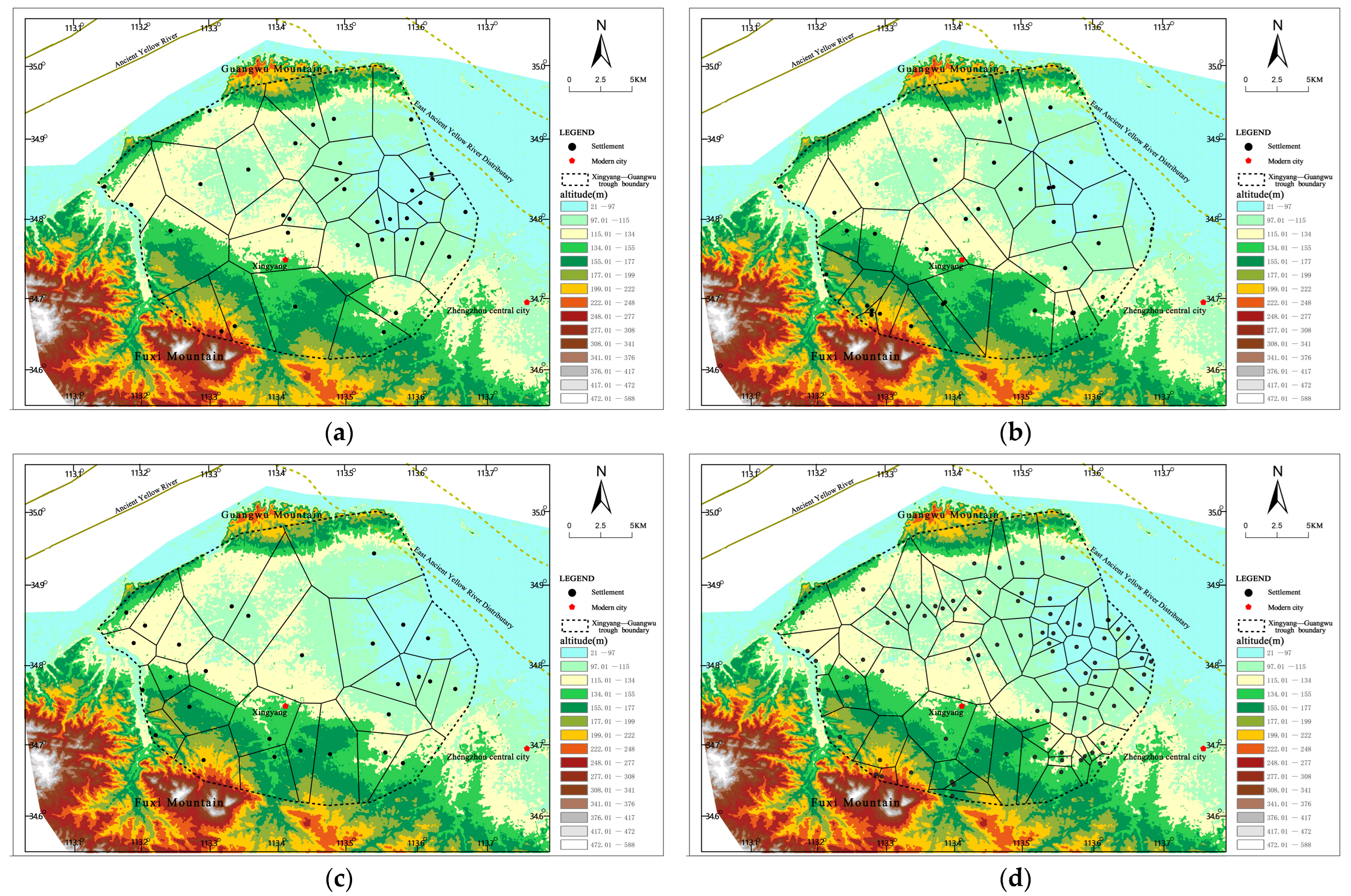
Based on the typical settlement aggregation areas identified by the above kernel density analysis, it was further divided using Thiessen polygons. According to the coefficient of variation (CV) of polygons in different periods, the aggregation degree and spatial distance of settlement sites were compared, and the aggregation degree and continuity characteristics of early settlement clusters were judged.
Thiessen Polygonal Analysis can clearly show the spatial distribution pattern of a set of points on the plane, which is judged by the coefficient of variation (CV). The coefficient of variation (CV) refers to the ratio of the standard deviation of the area of each polygon to the mean. When the points are evenly distributed, the polygon areas are similar, and the CV value is relatively small, but when the points are clustered, the polygon area difference is large, and the CV value is large [31].
2.2.4. Analysis Method of Settlement Cluster Structure
Studying the distance differences between settlements of different levels and surrounding lakes and swamps can help us identify the spatial structure of settlement clusters under specific geographical factors. This distance difference can be analyzed by the ArcGIS buffer analysis tool. Taking lakes and swamps as the main bodies, multi-ring buffer zones with different radii were established and then spatially connected with settlement sites. Finally, the number of sites in buffer zones with different radii was counted, through the comparison of the number of sites, to find the spatial pattern.
3. Results
3.1. Identification of Typical Aggregation Areas of Early Sites in the Yellow River Distributary in Zhengzhou
3.1.1. Characteristics of Sites Density Distribution
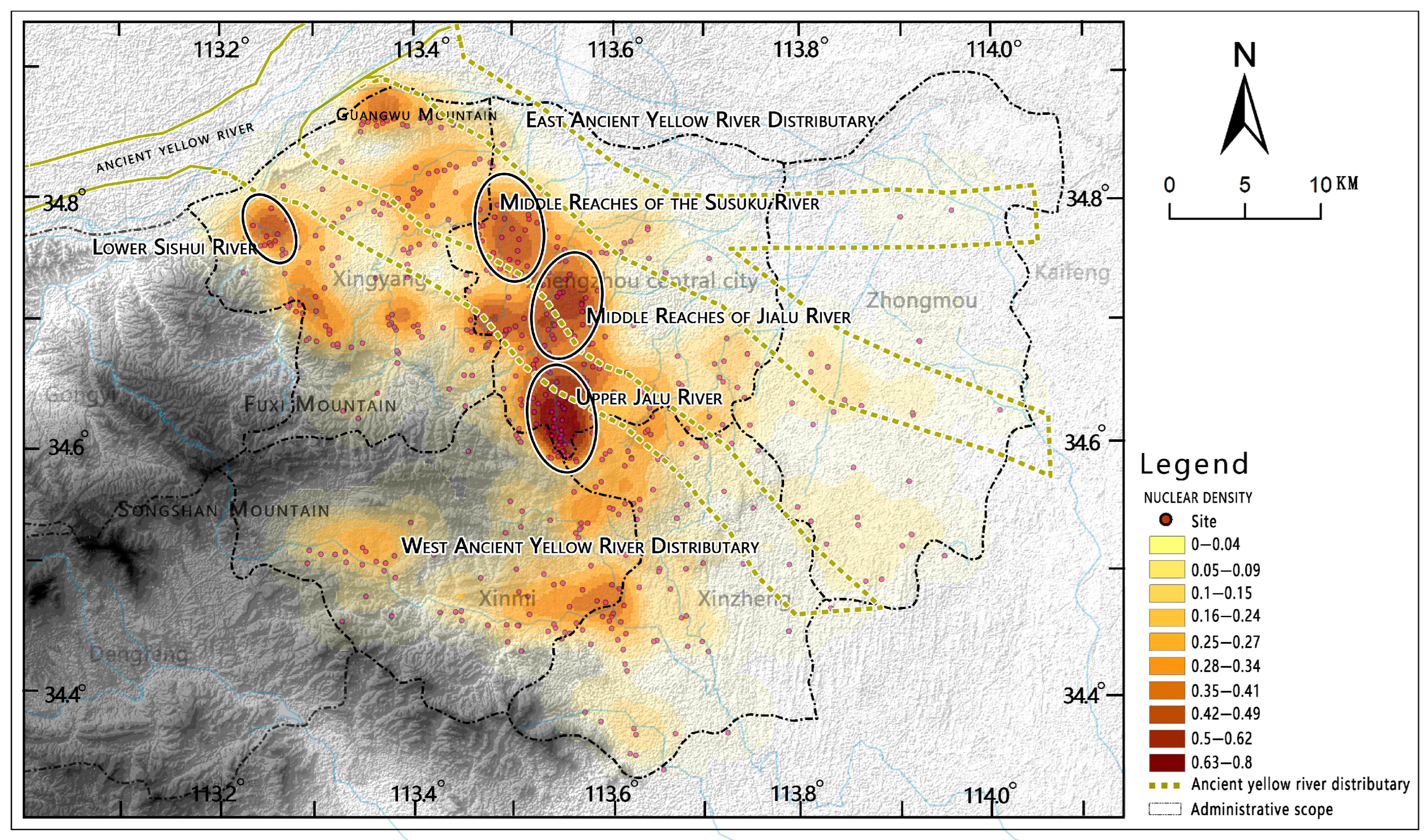
According to the relevant research and experimental analysis of the search radius and based on the overall scale of the study area, 4 km was selected as the search radius, and the kernel density analysis of the site data was carried out and visualized (Figure 3). The overall features are as follows:
- (1)
- There were aggregation differences between the east and the west. The sites were mainly distributed in the western part of Zhengzhou City. The area where the west ancient Yellow River distributary once flowed had the characteristics of ribbon-like aggregation distribution. In the area where the east ancient Yellow River distributary once flowed, there were few sites and no gathering centers.
- (2)
- Aggregation centers were in multi-level distribution patterns. On the whole, the first-level aggregation centers were mainly the aggregation centers in the middle reaches of the Suo-xu-ku River, the upper reaches of the Jialu River, and the middle reaches of the Jialu River. The three aggregation centers together formed the highest peak of aggregation density. In addition, the downstream area of the Sishui River formed secondary aggregation centers.
To sum up, the sites were mainly located along the area where the west ancient Yellow River distributary once flowed, forming a ribbon-like aggregation feature composed of multiple centers. The aggregation centers were the most concentrated in the middle reaches of the Suo-xu-ku River within the Xingyang–Guangwu trough and in the upper and middle reaches of the Jialu River.
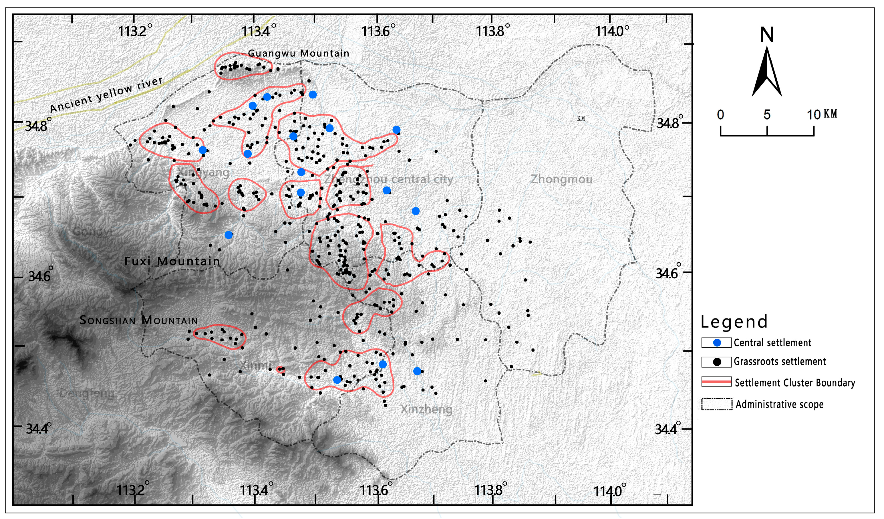
3.1.2. Complexity Analysis of Settlement Clusters
First, the research used “topographic map” of settlement density to divide the settlement clusters in each period, then extracted the contour lines with a kernel density value greater than 0.2 (this value was selected to show the settlement distribution pattern) and divided the clusters according to the actual topography. Second, the research analyzed the complexity of the settlement cluster structure in each period. The degree of structural complexity of a settlement cluster with two or more central settlements is high, the degree of structural complexity of a settlement cluster with only one central settlement is average, and the degree of structural complexity of a settlement cluster without a central settlement is low. The determination of the central settlement was based on the existing archaeological classification of the settlement levels in the Zhengzhou area [15,16] (Figure 4), which mainly presented the following characteristics:
- (1)
- From the perspective of the number of settlement clusters, there was a large quantity of settlement clusters in the Xingyang–Guangwu trough and along the Jialu River.
- (2)
- From the perspective of the complexity of the settlement clusters, the settlement clusters inside the Xingyang–Guangwu trough were relatively complex, and most of them had multiple central settlements. The settlement clusters distributed along the Jialu River were mostly low-complexity settlement clusters with only one central settlement within the cluster.
To sum up, the early settlement clusters in the Xingyang–Guangwu trough area had a large number of clusters and high complexity.
3.1.3. Determination of Typical Settlement Aggregation Areas
By analyzing the overall density distribution pattern of the settlements and comparing the complexity of settlement clusters, it was found that the aggregation center in the middle reaches of the Suoxuku River in the Xingyang–Guangwu trough had a high aggregation degree, and more complex settlement clusters were formed in the Xingyang–Guangwu trough. At the same time, because the Xingyang–Guangwu trough was the main flow area of the west ancient Yellow River distributary, this area was selected as a typical settlement aggregation area. The relationship between the morphology of settlements in the region and the ancient lakes and swamps was further analyzed.
3.2. Spatial Aggregation Characteristics of the Xingyang–Guangwu Trough in the Typical Settlement Aggregation Area
The study selected 128 settlements in different periods and different hierarchy structures in the Xingyang–Guangwu trough area to analyze the relationship between their aggregation characteristics and the ancient lakes and swamps.
3.2.1. Evolution of Aggregation Degree of Sites
Through the Thiessen polygon division of the sites in the Xingyang–Guangwu trough area, the changes of the coefficient of variation (CV value) of polygons and the difference of the positive value of the domain area in each period were analyzed. These two values helped to study the evolution process of mutual distance and aggregation of sites in the area, and then to estimate the degree of resource and environmental impacts (Figure 5 and Table 1).
The sites were distributed in clusters and were greatly affected by environmental changes. Relevant studies have shown that when the CV value of the Thiessen polygon of sites within a certain geographical range between 0.64 and 0.92, there is then an aggregation pattern, and the larger the value, the higher the degree of aggregation. In the Xingyang–Guangwu trough area from the Yangshao period to the Xia–Shang Dynasties, the CV values of sites were all higher than 0.64, showing a significant clustering distribution pattern [32]. Among them, the distance between the sites of the Shang Dynasty was the closest, and the aggregation degree was the highest (Table 1)). In addition, the CV value and the positive difference of the domain area fluctuated in a wide range in each period, indicating that the number and distribution of the sites were greatly affected by the environment.
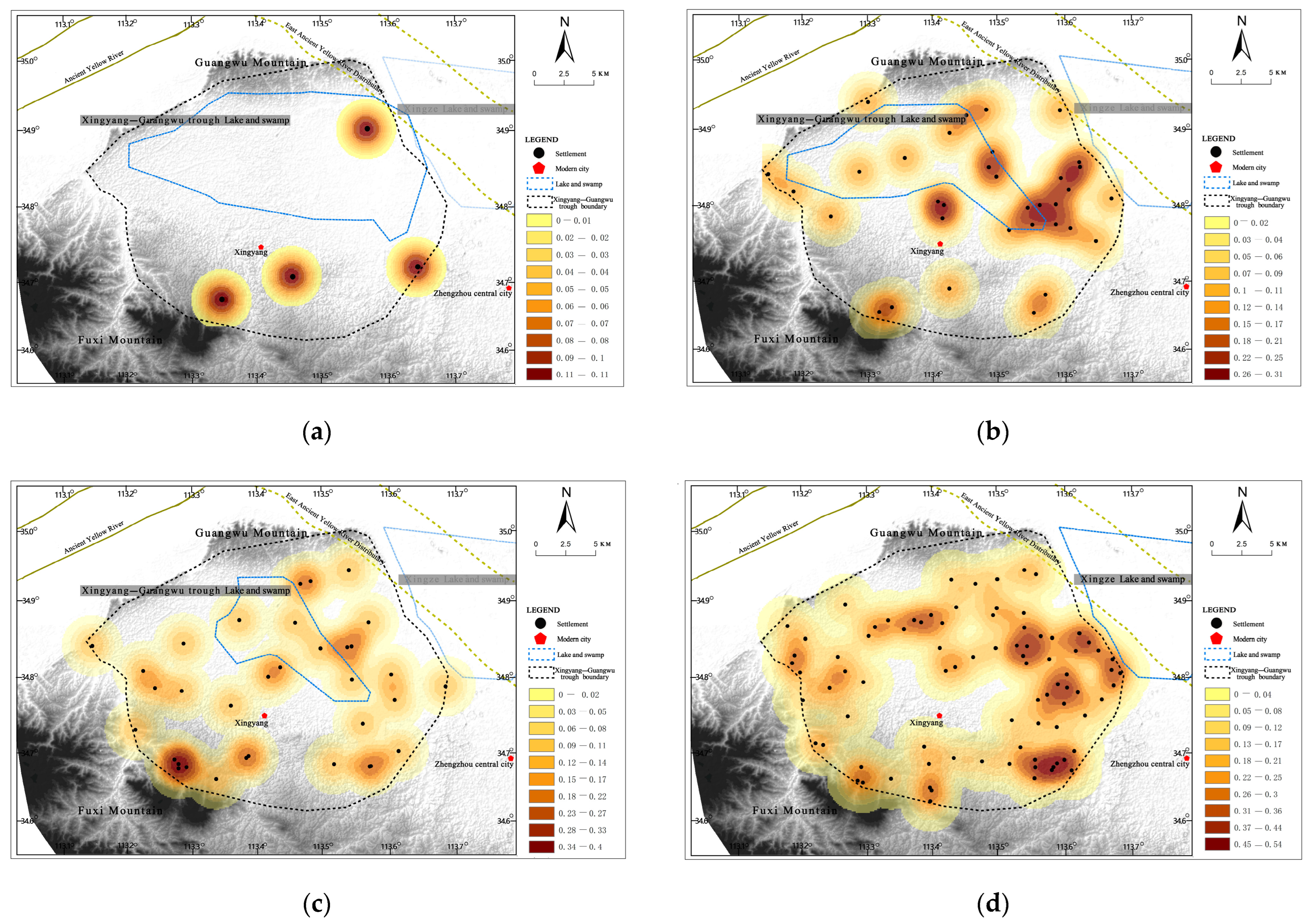
3.2.2. Evolution of Lake and Swamp and Distribution Characteristics of Settlement Density in Different Periods
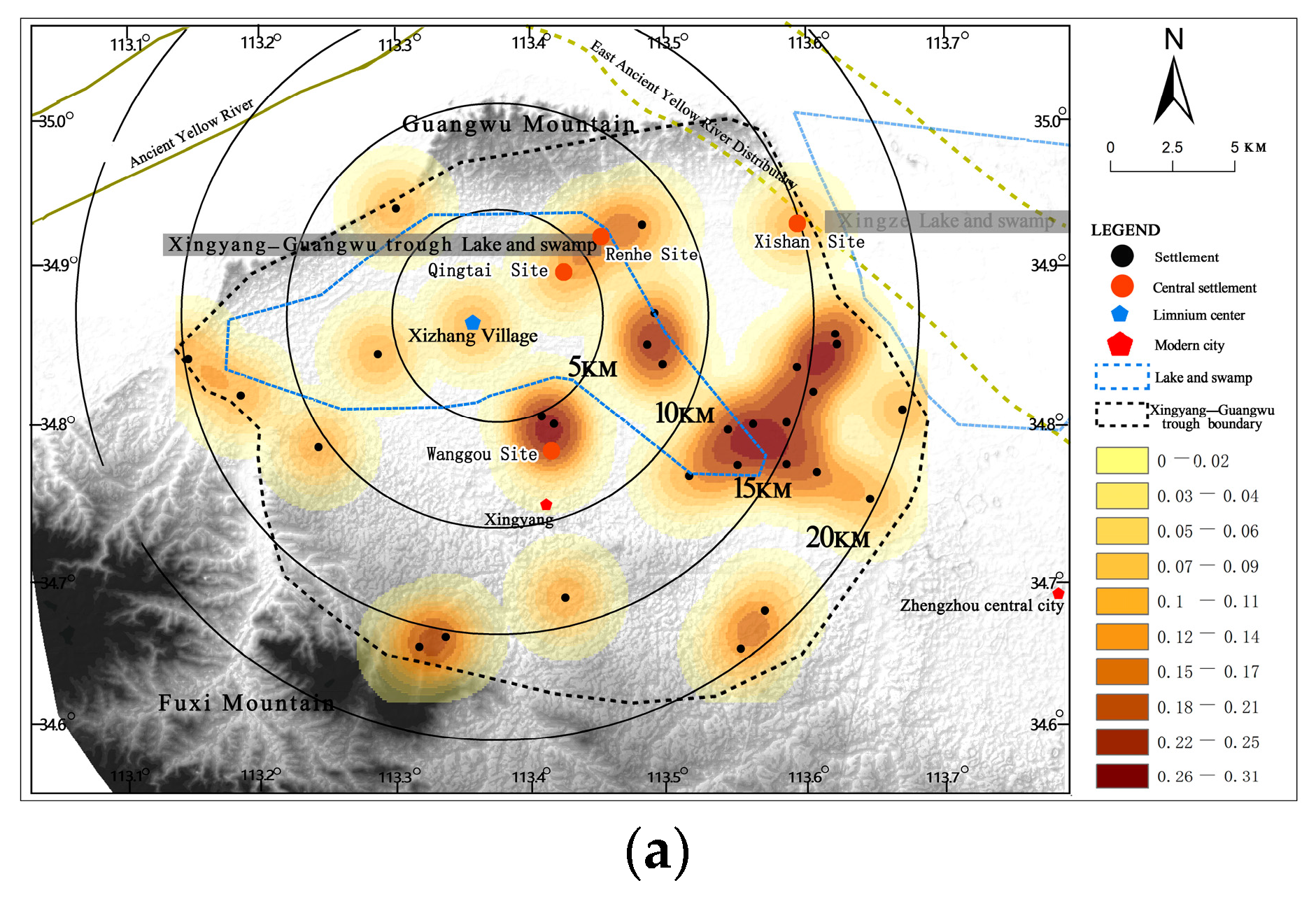
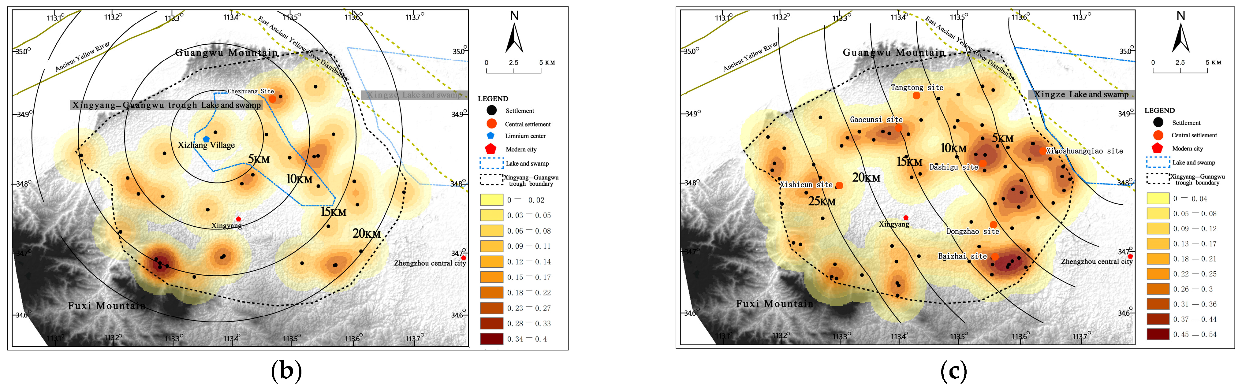
Further kernel density analysis was performed on the site data in different periods, and visual processing was performed. According to relevant research and experimental analysis of the search radius and based on the overall scale of the Xingyang–Guangwu trough, 2 km was selected as the search radius of the kernel density analysis. At the same time, spatial overlay analysis was carried out on the ranges of the lakes and swamps and the kernel densities in different periods (Figure 6).
The sites from the Peiligang period to the Xia–Shang Dynasties were mainly concentrated to the east of the Xingyang–Guangwu trough. With the changes of the lakes and swamps, the density distribution of sites in different periods had certain differences. Specifically:
- (1)
- During the Peiligang period, the lakes and swamps were in the largest range and were widely distributed in this area. During this period, there were few sites around the lakes and swamps, and no aggregation centers were formed.
- (2)
- During the Yangshao period, the northern and western boundaries of the lakes and swamps did not change much, but the southern boundary receded to the north, and the eastern boundary receded to the west. With the recession of the eastern boundary of the lakes and swamps, the sites formed three aggregation centers in the east.
- (3)
- During the Longshan period, the western boundary of the lakes and swamps receded. The number of sites remained basically unchanged during this period, but the sites spread to the west of the lakes and swamps, forming two aggregation centers in the east and west.
- (4)
- During the Xia and Shang Dynasties, the lakes and swamps in the Xingyang–Guangwu trough disappeared, while the lakes and swamps in the east of the area with the Xingze lake as the center were in a stable period. During this period, the number of sites increased significantly, mainly located in the eastern part of the Xingyang–Guangwu trough and close to the Xingze lake and formed a gathering center, with Xiaoshuangqiao, Baizhai Mall, Daishigu, and other city sites as the core.
3.2.3. Analysis of the Distance Relationship between Settlements of Different Levels and Adjacent Lake and Swamp
The settlements of different scales and levels in the Xingyang–Guangwu trough area showed differences in distance from the surrounding lakes and swamps. Through the analysis of the relative distance between the two, the relationship between the spatial distribution characteristics of the settlement hierarchy and the lakes and swamps in different periods was explored. During the Yangshao and Longshan periods, Xingyang–Guangwu trough lakes and swamps still existed. Xizhang Village in the center of the lakes and swamps was selected as the center point, 5 km was the radius interval, and four buffer zones were divided; during the Xia and Shang Dynasties, the Xingyang–Guangwu trough lakes and swamps disappeared, but the Xingze lake on the east side of the trough still existed, which had an impact on the settlements in this area. However, the central location of the Xingze lake is still controversial. In this research, the western boundary of the Xingze lake, which is academically accepted, was selected as the reference point, and four buffer zones were divided with 5 km as the radius interval, counting and analyzing the number of settlements based on the hierarchy system in each buffer zone (Figure 7).
The results show that from the Yangshao period to the Xia–Shang Dynasties, the central settlements were generally located in the buffer zone of 5 km and 10 km close to the lakes and swamps, and the general settlements were mainly located in the middle and outer buffer zones of 15 km and 20 km. Furthermore, the number reached the maximum in the 15 km buffer zone, and the number outside 15 km began to gradually decrease.
The results in different periods are as follows: During the Yangshao period, the central settlements such as Qingtai and Wanggou settlements were concentrated in the 5 km and 10 km buffer zones in the eastern half of the lakes and swamps. The number of general settlements reached the maximum in the 15 km buffer zone and began to decrease in the 20 km buffer zone. In the Longshan period, there existed only the Chezhuang central settlement. Within the 10 km buffer zone in the center of the lakes and swamps, the number of general settlements reached the maximum within the 15 km buffer zone and began to decrease within the 20 km buffer zone. During the Xia–Shang Dynasties, the Xiaoshuangqiao settlement at its highest level concentrated in the buffer zone of 5 km. Central settlements such as the Dashigu settlement and Dongzhao settlement were located in the buffer zone of 10 km to 15 km. The number of general settlements reached the maximum in the buffer zone of 10 km and began to decrease in the buffer zone of 15 km (Table 2).
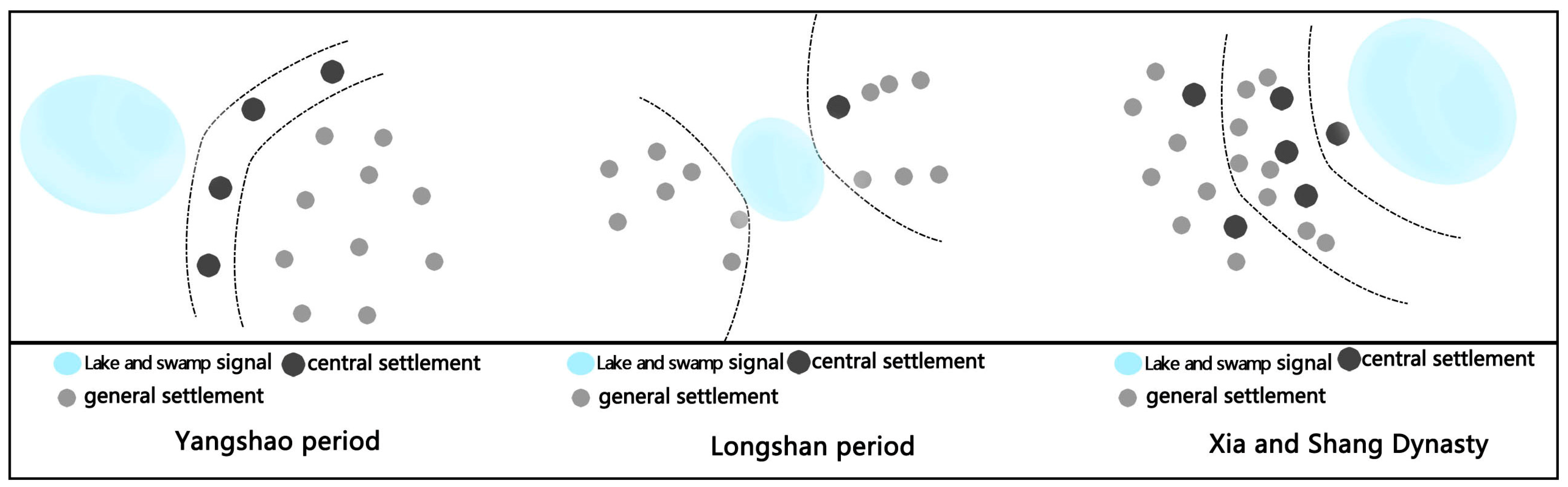
3.3. The Relationship between the Hierarchical Structure of Early Settlement Clusters and Lakes and Swamps
Through the above analysis of the aggregation characteristics of the settlements in the Xingyang–Guangwu trough area, the following conclusions are offered: Due to the unique environment and geographical condition of the lakes and swamps, the hierarchical structure of early settlement communities clearly showed a concentric distribution around the lakes and swamps. This feature indicates that the early settlement clusters were closely related to the interactive development of the lakes and swamps. The specific pattern of this feature in different periods is as follows (Figure 8):
- (1)
- During the Yangshao period, central settlements were distributed in the nearest circle around the Xingyang–Guangwu trough lakes and swamps. The general settlements were mostly distributed in the outer circle. From the inner circle to the outer circle, the number of settlements first increased and then decreased, forming a concentric distribution feature surrounding lakes and swamps as a whole.
- (2)
- During the Longshan period, the settlements were distributed around the Xingyang–Guangwu trough lakes and swamps, and the number gradually decreased from the inside to the outside.
- (3)
- During the Xia and Shang dynasties, the Xingyang–Guangwu trough lakes and swamps disappeared, and the overall settlement structure reversed direction, forming a concentric distribution around the eastern Xingze lake. The highest-level settlement was distributed in the innermost circle, the secondary level settlement was located in the middle circle, and the general settlements were scattering around each central settlement.
4. Discussion
The evolution of the ancient Yellow River distributary and its lakes and swamps had a significant impact on the early human living environment. Since the early Holocene, the west distributary of the ancient Yellow River disappeared, and the east ancient Yellow River distributary continued to flood, affecting the Xingyang–Guangwu trough area. The disappearance of the ancient Yellow River distributary provided the area with abundant natural resources. For example, flat, vast, and fertile land could be used for agricultural activities, and lake and swamp water resources could be used as fisheries. According to the research report of the animal bones collected in this area, the Chinese round snail and mussels accounted for 23% of the total [33]. A large number of freshwater wildlife found in this area could be closely related to the large area of shallow water lakes. Since the Shang Dynasty, the large-scale flat and fertile land after the disappearance of the western lakes and swamps provided a vast hinterland, and a complete and complex hierarchical settlement system was developed in this area. This spatial distribution characteristic fully demonstrates the harmonious relationship between humans and water under the influence of the ancient Yellow River distributary.
The data for this study were obtained from a multidisciplinary field. At present, the geographical environment, such as paleoclimate, paleogeology, and sedimentary experiments and determinations of rivers and lakes, are still in progress, and the archaeological investigation, exploration, and excavation of the sites in this area are still ongoing. This will provide more information and data for further in-depth analysis of this research and more precise lake and swamp boundaries and the resulting geographical units in each period will be clarified. It will contribute further to the study of the spatial connection between the sites.
5. Conclusions
Based on the geographical environment of the ancient Yellow River distributary and the vectorized data of early sites, this research uses the GIS spatial quantitative analysis method. From a multi-dimensional perspective, the typical settlement aggregation area (Xingyang–Guangwu trough area) of the ancient Yellow River distributary in Zhengzhou is identified. The study focuses on the area and conducts an overlay analysis of settlement in different periods, ancient lakes and swamps, topography, and other information. It shows the relationship between the changes of the ancient lakes and swamps and the aggregation degree, density distribution, and the evolution pattern of the settlement structure of the early sites. Research indicates:
- (1)
- From the Peiligang period to the Xia and Shang dynasties, the early sites in the area where the ancient Yellow River distributary once flowed through show ribbon-like clustering features with multiple centers. The Xingyang–Guangwu trough area, which is a typical settlement area in the ancient Yellow River distributary area, is numerous and has a high degree of complexity of aggregations.
- (2)
- The aggregation degree of settlements in the Xingyang–Guangwu trough area in different periods were high, but there were some fluctuations, which shows that it was greatly affected by changes in the external environment. The aggregation density of settlements changed with the evolution of lakes and swamps. From the distance between different levels of settlements and lakes and swamps, central settlements were located near the lake and swamp zone, and other settlement stayed far from the zone. The number of sites from the lake increased first and then decreased.
- (3)
- From the Yangshao period to the Xia and Shang Dynasties, the settlement cluster presented a distribution pattern of centric zones around the lakes and swamps. From the perspective of space, the distribution of centric zones around Xingyang–Guangwu trough lakes and swamps in the west moved to the Xingze lake in the east. Previous research pointed out the ubiquitous early settlements along the river. The pattern of centric distribution is more applicable based on the relation between the hierarchical structure of settlement clusters and the lake and swamp environments.
The early settlements showed aggregation characteristics under the influence of the ancient environments. This paper explores the mechanisms of settlement formation in such areas, and the research hopes to provide strong support for the systematic protection and overall display and utilization of cultural heritage-intensive areas.
Author Contributions
J.L., Y.S., W.Z. and J.Z. contributed equally to this research. Conceptualization, J.L. and Y.S.; writing—original draft, W.Z., J.L. and J.Z.; methodology, W.Z.; formal analysis, W.Z. and J.Z.; project administration, J.L.; writing—review and editing, J.Z. and Y.S.; funding acquisition, Y.S. All authors have read and agreed to the published version of the manuscript.
Funding
This research received no external funding.
Institutional Review Board Statement
Not applicable.
Informed Consent Statement
Not applicable.
Data Availability Statement
The data presented in this study are available on request from all the authors.
Acknowledgments
All authors sincerely thank to Zhe Liu (School of architecture, Zhengzhou University) for his guidance on the language translation problem of the manuscript.
Conflicts of Interest
The authors declare no conflict of interest.
References
- Qiu, M.; Zuo, Q.; Wu, Q.; Yang, Z.; Zhang, J. Water Ecological Security Assessment and Spatial Autocorrelation Analysis of prefectural regions involved in the Yellow River Basin. Sci. Rep. 2022, 12, 5105. [Google Scholar] [CrossRef] [PubMed]
- Hou, W.; Huang, P.; Jiang, H.; Sun, M. Practice and Thinking of Yellow River Archaeology and Cultural Heritage Protection. Huaxia Archaeol. 2020, 6, 118–120 + 124. [Google Scholar]
- Storozum, M.; Lu, P.; Wang, S.; Chen, P.; Yang, R.; Ge, Q.; Cao, J.; Wan, J.; Wang, H.; Qin, Z.; et al. Geoarchaeological Evidence of the AD 1642 Yellow River Flood that Destroyed Kaifeng, a Former Capital of Dynastic China. Sci. Rep. 2020, 10, 3765. [Google Scholar] [CrossRef] [PubMed]
- Zhang, Y.; Li, J.; Zhao, Y.; Wu, X.; Li, H.; Yao, L.; Zhu, H.; Zhou, H. Genetic Diversity of Two Neolithic Populations Provides Evidence of Farming Expansions in North China. J. Hum. Genet. 2017, 62, 199–204. [Google Scholar] [CrossRef] [PubMed]
- Xu, H. An Analysis of Zhengzhou’s Ancient Geographical Environment and Culture; Science Press: Beijing, China, 2015; p. 15. [Google Scholar]
- Li, Y.F.; Yu, G.; Li, C.H.; Hu, S.Y.; Shen, H.D.; Yin, G. Environment Reconstruction of Mid-holocene Paleo-lakes in Zhengzhou and Surrounding Region and the Significance for Human Cultural Development in Central China. Mar. Geol. Quat. Geol. 2014, 34, 143–154. [Google Scholar]
- Yu, G. Sedimentology of Lake-River Systems and Environmental Evolution in Zhengzhou Regions; Science Press: Beijing, China, 2016; pp. 75–81. [Google Scholar]
- Wu, H. The Research on Spatial Patterns of the Distribution of Prehistoric Settlements in Central Plains. Master’s Thesis, Henan University of Technology, Henan, China, 2010; pp. 52–57. [Google Scholar]
- Shi, B. Settlement Spatial Organization in Central Plains China during the Period of Transition from Late Neolithic to Early Bronze Agenze ion from B.C.e. Master’s Thesis, Jilin University, Jilin, China, 2014; pp. 275–279. [Google Scholar]
- Li, Z.; Wu, G.; Zhu, C.; Zheng, J.; Li, K.; Jiao, S. Spatial and Temporal Pattern of the 4.2-3.5 ka BP Settlements and its Succession Models in the South of the Songshan Mountain. Acta Geogr. Sin. 2016, 71, 1640–1652. [Google Scholar]
- Li, Z.; Wu, G.; Sun, Y.; Jiao, S.; Zhu, C. The Adaptation of Prehistoric Society of 4.2~3.5 ka B.P.to the Environment Stress in the Southern Songshan Mountain. Mt. Res. 2018, 36, 833. [Google Scholar]
- Tao, D.; Xu, J.; Wu, Q.; Richards, M.P.; Zhang, G. Human Diets, Crop Patterns, and Settlement Hierarchies in Third Millennium BC China: Bioarchaeological Perspectives in Zhengluo Region. J. Archaeol. Sci. 2022, 145, 2–8. [Google Scholar] [CrossRef]
- Bi, S.; Ji, H.; Yang, H. Clustering Analysis of the Neolithic Settlement Sites in Zhengzhou-Luoyang Area Based on DBSCAN. Sci. Technol. Eng. 2014, 14, 266. [Google Scholar]
- Song, A. Analysis of Settlement Form in Zhengzhou from Prehistoric to Shang and Zhou Dynasties. Master’s Thesis, Shandong University, Shandong, China, 2006; pp. 11–43. [Google Scholar]
- Zhang, H. The Origins of Civilization in the Core Area of Central Plain; Shanghai Classics Publishing House: Shanghai, China, 2021; pp. 230, 280–281. [Google Scholar]
- Zhao, C. The Evolution of Neolithic Settlements in Zhengluo Area; Peking University Press: Beijing, China, 2001; pp. 89–92, 142–156. [Google Scholar]
- Yan, L.; Shi, Y.; Lu, P.; Liu, C. Relationship between Prehistoric Settlements Location and River around Songshan Mountain Area. Areal Res. Dev. 2017, 2, 173. [Google Scholar]
- Lu, P. Temporal and Spatial Patterns of Prehistoric Settlement Distribution and Its Formation Mechanism in the Surrounding Songshan area; Science Press: Beijing, China, 2017; pp. 23–102. [Google Scholar]
- Bi, B.; Wang, J.; Ji, H.; Shen, X.; Ling, D. Analysis of Driving Factors for Environment of Prehistoric Settlement Sites in Zhengzhou-Luoyang Area. Geogr. Geo-Inf. Sci. 2017, 337rap, 119. [Google Scholar]
- Yan, L. Mining Technique and Method of Spatial and Temporal Distribution of Prehistoric Settlements—A Case of Songshan Region; China Agricultural Science and Technology Press: Beijing, China, 2019; pp. 82–102. [Google Scholar]
- Li, S.; Ma, Y.; Guo, Y.; Du, J.; Wang, D. Relationship between Distribution Features of Ancient Settlements and Changes of River and Lake Prior to Western Zhou Dynasty in Zhengzhou Area. Areal Res. Dev. 2019, 38, 171–176. [Google Scholar]
- National Cultural Heritage Administration. The Atlas of Chinese Cultural Relics: Henan Volume; Cultural Relics Publishing House: Beijing, China, 2009; pp. 60–72. [Google Scholar]
- Lu, P.; Tian, Y.; Yang, R.X. The Study of Size-Grade of Settlements around the Songshan Mountain in 9000~3000 aBP Based on SOFM Networks. Acta Geogr. Sci. 2012, 67, 1375–1382. [Google Scholar]
- Xu, H. The Late Pleistocene to Early-middle Holocene Lacustrine Sedimentary Environment on the Top of the Alluvial Fan of the Yellow River—A case study of “Xingyang-Guangwu Ze” Lake, Xing Ze Lake and Putian Ze Lake in Zhengzhou regions. J. Archaeol. Sci. River Civiliz. Sustain. Dev. 2021, 1, 209–234. [Google Scholar]
- Zhang, H. The application of ArcView on the study of settlement archaeology in Central China area. Huaxia Archaol. 2004, 1, 98–106, 113–114. [Google Scholar]
- Robert, D.D.; Christian, E.P. Comparing archaeological settlement systems with rank-size graphs:a measure of shape and statistical confidence. J. Archaeol. Sci. 2004, 31, 533–549. [Google Scholar]
- Niu, Q. Urban and Rural Planning GIS Technology Application Guide GIS Methods and Classical Analysis; China Construction Industry Press: Beijing, China, 2019; pp. 198–199. [Google Scholar]
- Zhan, D.; Zhang, W.; Zhang, J.; Li, J.; Chen, L.; Dang, Y. Identifying urban public service facilities centers in Beijing. Geogr. Res. 2020, 39, 554–569. [Google Scholar]
- Liu, L. The Chinese Neolithic: Trajectories to Early States; Cultural Relics Publishing House: Beijing, China, 2007; pp. 78, 221–232. [Google Scholar]
- Niu, A. The Distribution of Prehistoric Settlements and Evolution of Cultivated Land Pattern in Hehuang Valley. Master’s Thesis, Huaqiao University, Quanzhou, China, 2018; pp. 30–31. [Google Scholar]
- Duyckaerts, C.; Godefroy, G. Voronoites sellation to study the numericalden-sity and the distribution of neurons. J. Chem. Neu-Roanatomy 2000, 20, 83–92. [Google Scholar] [CrossRef]
- Wang, X.; Liu, J.; Zhuang, D.; Jiang, Y. The application of Voronoi diagram on spatial organizing of urban influence regions. J. Cent. China Norm. Univ. (Nat. Sci.) 2003, 2, 256–260. [Google Scholar]
- You, Y.; Hou, W.; Liu, Y.; Shi, Y. Archaeological Survey of Suo, Xu and Ku River Basin in Zhengzhou City, Henan Province, Collection of Animal Skeleton Research Report. Archaeol. Luoyang 2015, 2, 79–81. [Google Scholar]
Figure 1.
Research scope and location map.

Figure 2.
Location map of sites and ancient lakes and swamps in different periods.

Figure 3.
Overall kernel density analysis map of the study area.

Figure 4.
Complexity analysis of settlement clusters in the study area.

Figure 5.
Thiessen Polygonal Analysis map of Xingyang–Guangwu trough. (a) Yangshao period; (b) Longshan period; (c) Xia Dynasty; (d) Shang Dynasty.
Figure 5.
Thiessen Polygonal Analysis map of Xingyang–Guangwu trough. (a) Yangshao period; (b) Longshan period; (c) Xia Dynasty; (d) Shang Dynasty.

Figure 6.
Kernel density analysis map of Xingyang–Guangwu trough. (a) Peiligang period; (b) Yangshao period; (c) Longshan period; (d) Xia and Shang Dynasty.
Figure 6.
Kernel density analysis map of Xingyang–Guangwu trough. (a) Peiligang period; (b) Yangshao period; (c) Longshan period; (d) Xia and Shang Dynasty.

Figure 7.
Buffer analysis map of Xingyang–Guangwu trough. (a) Yangshao period; (b) Longshan period; (c) Xia and Shang Dynasty.
Figure 7.
Buffer analysis map of Xingyang–Guangwu trough. (a) Yangshao period; (b) Longshan period; (c) Xia and Shang Dynasty.


Figure 8.
Concentric distribution map of early settlement circles.


Table 1.
Thiessen Polygon Analysis index table of Xingyang–Guangwu trough.
| Target | Yangshao Period | Longshan Period | Xia Dynasty | Shang Dynasty | ||||
|---|---|---|---|---|---|---|---|---|
| cv | area range | cv | area range | cv | area range | cv | area range | |
| Xingyang–Guangwu trough | 0.9 | 1.77–81.64 | 0.7 | 5.16–71.51 | 0.8 | 6.72–158.2 | 1.2 | 1.02–60.4 |
Table 2.
A table of the distance between settlements and lakes and swamps in the Xingyang–Guangwu trough area.
Table 2.
A table of the distance between settlements and lakes and swamps in the Xingyang–Guangwu trough area.
| Period | Settlement Level | 5 km | 10 km | 15 km | 20 km |
|---|---|---|---|---|---|
| Yangshao period | Central settlement | 1 | 2 | 1 | 0 |
| General settlement | 1 | 10 | 14 | 13 | |
| Longshan period | Central settlement | 0 | 1 | 0 | 1 |
| General settlement | 1 | 10 | 15 | 11 | |
| Xia and Shang Dynasty | Central settlement | 4 | 2 | 4 | 0 |
| General settlement | 9 | 20 | 15 | 8 |
Publisher’s Note: MDPI stays neutral with regard to jurisdictional claims in published maps and institutional affiliations. |
© 2022 by the authors. Licensee MDPI, Basel, Switzerland. This article is an open access article distributed under the terms and conditions of the Creative Commons Attribution (CC BY) license (https://creativecommons.org/licenses/by/4.0/).
Share and Cite
MDPI and ACS Style
Li, J.; Song, Y.; Zhang, W.; Zhu, J. Analysis of the Aggregation Characteristics of Early Settlements in the Zhengzhou Ancient Yellow River Distributary Area. Water 2022, 14, 2961. https://doi.org/10.3390/w14192961
AMA Style
Li J, Song Y, Zhang W, Zhu J. Analysis of the Aggregation Characteristics of Early Settlements in the Zhengzhou Ancient Yellow River Distributary Area. Water. 2022; 14(19):2961. https://doi.org/10.3390/w14192961
Chicago/Turabian StyleLi, Jiandong, Yating Song, Wei Zhang, and Jiajia Zhu. 2022. "Analysis of the Aggregation Characteristics of Early Settlements in the Zhengzhou Ancient Yellow River Distributary Area" Water 14, no. 19: 2961. https://doi.org/10.3390/w14192961
Note that from the first issue of 2016, this journal uses article numbers instead of page numbers. See further details here.