Article

Potential Toxic Impacts of Hg Migration in the Disjointed Hyporheic Zone in the Gold Mining Area Experiencing River Water Level Changes

1
Xi’an Center, China Geological Survey, Ministry of Natural Resources, Xi’an 710054, China
2
Field Base of Scientific Observation of Shannxi Tongguan, Ministry of Natural Resources, Xi’an 710054, China
3
Shaanxi Province Water Resources and Environment Engineering Technology Research Center, Xi’an 710054, China
4
Key Laboratory for Geo-hazards in Loess Area, Ministry of Natural Resources, Xi’an 710054, China
5
Dalian Ocean and Fishery Comprehensive Administration Supervision Lochus, Dalian 116000, China
6
Key Laboratory of Western China’s Mineral Resource and Geological Engineering, Ministry of Education, Xi’an 710054, China
7
School of Earth Science and Land Resources of Chang’an University, Xi’an 710054, China
8
Faculty of Science, Al-Azhar University, Assiut Branch 71524, Egypt
*
Authors to whom correspondence should be addressed.
Water 2022, 14(19), 2950; https://doi.org/10.3390/w14192950
Submission received: 31 August 2022 / Revised: 14 September 2022 / Accepted: 15 September 2022 / Published: 21 September 2022
(This article belongs to the Special Issue Groundwater Quality and Public Health)

Abstract

:
In order to study the occurrence form, vertical migration and transformation and the potential ecological risk of Hg in the disjointed hyporheic zone in the gold mining area is investigated. Through field investigation, in-situ test, and test analysis, the results show that: (1) the form of mercury in the original stratum where the river water-groundwater hydraulic connection is disconnected is mainly in the residual state, accounting for 77.78% of the total mercury; (2) after the water content increases or the water level changes, the various forms of occurrence in the soil surface layer decrease, and the residual state is still the main form; the main forms of mercury in the sand and pebble layer are diversified, including the residual state, strong organic state and humic acid state; (3) the mercury content in the subsurface zone in winter is higher than that in summer; (4) although the mercury content in groundwater has not been detected, the potential ecological risk of mercury in the disjointed Hyporheic zone near the river in the study area is much higher than the extreme ecological hazard threshold, which has a value of 320. The risk of groundwater pollution caused by mercury during the long-term runoff of the river is higher than that during the flood period. Therefore, relevant departments need to rectify the river as soon as possible, from the source to reduce the ecological risk of heavy metals to groundwater. The results will provide a scientific basis for groundwater control.

1. Introduction

The hyporheic zone is an important transitional area for the dynamic interaction of surface water and groundwater. Its physical properties and biogeochemical environment jointly carry the changing process of water flow, material, and energy exchange.
The hyporheic zone (HZ) is an essential member of a river ecosystem which can be saturated with interstitial sediment beneath the streambed and close to the riverbed (Figure 1a,b [1,2,3]). It is the zone of fraternization, exchange, and interaction between groundwater and surface water. The surface water and groundwater interacted and combine to create a new interstitial or transitional zone of water with different properties. The HZ can be divided into two zones, the “surface hyporheic” zone, and the “interactive hyporheic” zone. The new characteristics of the hyporheic zone are dynamic zone with hydraulic pressure at numerous scales (catchment scale and smaller scale) [4,5,6,7,8]. It has a higher concentrations of chemicals with low oxygen content, special hydrological processes, and ecological systems. Many hydrogeologists consider the hyporheic zone as part of the groundwater system, since it contains subsurface water in the saturated zone. The physiochemical characteristics of water flow in the subsurface are the main key to material and energy exchange between surface water and groundwater [9]. Due to the differences in physiochemical characteristics such as redox, pH, and temperature between river water and groundwater, drives variation in biological, chemical, and even temperature gradients between surface and groundwater.
Heavy metals are the extremely distributed deposits in the soil sediment and water nearby gold mining [10,11,12]. Heavy metals are classified into essential and nonessential metals. Heavy metals sources are categorized as natural sources such as ore deposits, bedrock weathering, geological weathering, atmospheric precipitation, storms, and wind bioturbation, whereas anthropogenic sources such as agrochemicals activities, mining processing, shipping, industrial products, manufacturing development and process (e.g., batteries and pharmaceutical products), smelting, fuel generation, electroplating, sludge discharge, energy transmission, dense urban areas, wastewater irrigation and [13,14,15]. Globally, the water discharges from the mining of ores, heaps leaching, milling and ore processes to liberate the metal and remove the waste are predominantly sources of metals in soil, surface, and groundwater pollution around these mine areas. Mine waters are typically rich in metals and elements such as iron, copper, manganese, arsenic, mercury, lead, and zinc [16,17,18,19]. By water-rock interaction, the heavy metals move to water in order to sediment and can accumulate in water or soil by bioaccumulation processes, which may enter the food chain and create a health risk. Consequently, detecting the processes of surface and groundwater interface is highly significant to evaluate and assume the behavior and consequences of mine pollution. The main four attributes which controlled the element behavior in certain heavy metals are the valence state, compound state, binding state, and structural state [20]. In addition to the stability of the element in the soil organized the occurrence form of this element.
Mercury is one of the most critical pollutions and ranked the third most toxic elements by the US Government Agency for Toxic Substances and Disease Registry [21,22,23]. As well as this, it is one of the main pollutant structures in the gold mining areas [24,25]. It can reach the human body through food and water which can act naturally by ore rock interaction or by human activities (by using dental amalgam, batteries, thermometers, barometers, and medical waste) in modern life. Mercury (inorganic or as organic) can bioaccumulate in soil and water and cause bad effects on human health [26,27,28].
When mercury enters the soil, various forms will be redistributed among the soil solid phases. MA et al. [29] revealed that there are significant differences in the mass concentrations of dissolved mercury (DHg) and total methyl mercury (TMeHg) in the stratum water samples in the water storage period (September to October), submerged period (November to December), water withdrawal period (February to March) and drying period (May to June). Changes in the surface water level will cause the content of heavy metals and the occurrence of environmental changes [30,31]. Wang [32] studied the change in mercury under laboratory conditions, he concluded that the content in different forms under dry and wet environments after flooding, shows the mercury Migration ability is: acid-soluble mercury > inert mercury > Alkali-soluble mercury > water-soluble mercury; and under the condition of drying, inert mercury > alkali-soluble mercury > acid-soluble mercury > water-soluble mercury. On the other hand, Tang [33] studied the speciation distribution of mercury in wetland sediments with different water level gradients, and he noticed that the change in groundwater level is directly affected by the river water level during high and low water seasons, and the fluctuation of surface water level causes different changes in the content of water and polluting elements in the soil layer [34]. The river water and groundwater level in the hyporheic zone in the wet season and dry season directly affect the risk of groundwater pollution [35,36], and the disconnected hyporheic zone is the bottom line for an early warning of regional pollution risks, so the development of disconnected river reaches. It is very important to study the vertical migration of the mercury information profile and its ecological risk.
Analysis of water, sediments, and members of indigenous biota can be used to determine the relative pollution of aquatic habitats by mercury and other heavy and trace metals. This analysis includes different monitoring techniques, and scientific problem usually include soil and water quality, hydrological processes composition of vegetation, and animal population. Previous studies mainly focus on reports on the potential ecological hazard assessment of heavy metal pollution in static water and soil environments [37,38]. The migration and transformation rules and ecological risks of mercury occurrence forms in the subsurface under the conditions of river water level changes in wet and dry periods are not well studied. The research topic provides a scientific basis for the prevention and control of groundwater pollution along the river.
Xiaoqinling gold-mining area is considered the third largest gold-producing region in China, and gold production in the area began about 900 years ago. In Mayu alone, there are 72 abandoned ancient mines, and production from 1980 to 2003 reached 562,500 t [39]. Furthermore, the large-scale exploitation of gold and mining activities began in 1975 [40]. Currently, more than 29 large gold mining companies have many gold mills, which are mainly in the Shuangqiao river. Based on the geochemical characteristics landscape of the region, five areas are included (Figure 1a,b): the prockbase mountain area, piedmont alluvial-pluvial inclined tableland, loess ravine tableland, Yellow river, Weihe and Shuangqiao river alluvial terrace [40]. Both agricultural activities and gold-mining activities were commonly affected in the study area. The more complicated structures include faults and folds in the north and south, the main regional faults are the Taiyao, Guanyintang, Xiaohe, and Huanchiyu. The structure system influences the heavy mineral distribution in the study area. Several gold mills are scattered along numerous streams which are tributaries of the Yellow river. Since mining pactivities during the 1980s to 1990s, artisanal gold in which elemental Hg has been used widely for gold processing [39]. Up to the present time, wastewater is still discharged directly into rivers and streams due to more than eight million tons of tailings having been produced with high-risk pollution of heavy metals for the soil and water. The main sources of heavy and trace elements especially Hg in the polluted soil were identified through the correlation analysis and comparing the maps of these heavy metal concentrations distribution and land-use types [41]
The Shuangqiao River in the Xiaoqinling gold mining area is a typical area of mercury pollution [42,43]. Xu et al. [44] studied mercury pollution in the sediment. The soil content is significantly higher than that of the three geochemical landscapes: the piedmont alluvial-proluvial slope, the loess gully residual plateau, and the Huangwei River alluvial plain; the accumulation or pollution of heavy metals caused by mining activities becomes the soil Hg, Pb, Cd, Cu, and Zn in the study area. Owing to the chemical factor affecting the enrichment of heavy metals in soil [45], the gold mining activities are closely related to Hg in the Hyporheic zone of the study area, the authors studied the disjointed continuous type in dry season. The migration law and influencing factors of Hg morphological characteristics in the subsurface zone in the vertical soil layer [42].

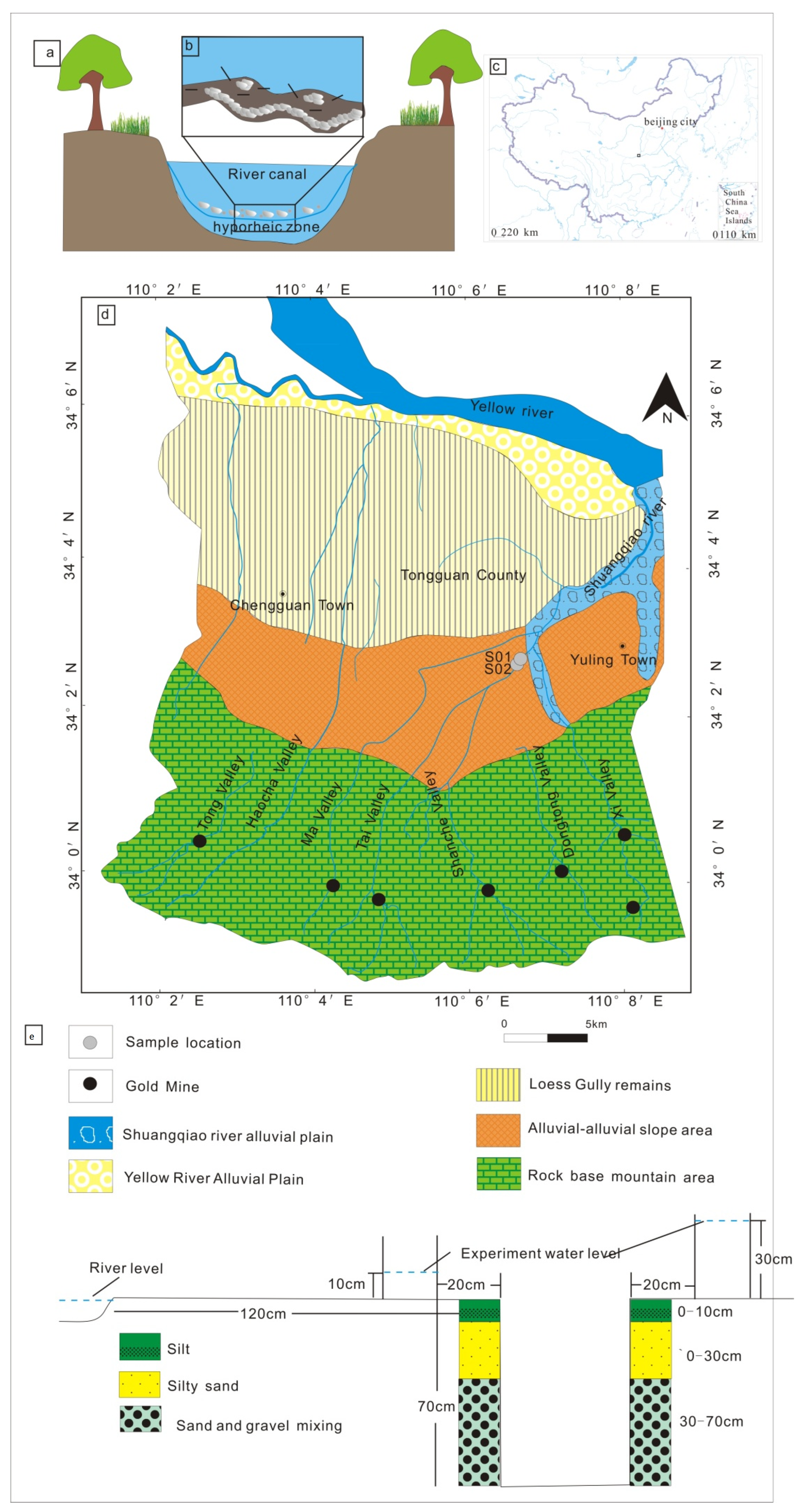
2. Background of the Study Area

The Shuangqiao River originates from the northern foot of the Xiaoqinling Mountains and is formed by the confluence of Mayu, Taiyu, Shancheyu, Dongtongyu, and Xiyu. region (Figure 1c,d [46]). Its flow direction is from south to north, with a length of 14.8 km. It belongs to the warm temperate continental monsoon semi-humid-humid climate zone, with dry winters and little rain, and humid and rainy summers. The annual precipitation is 587.4 mm and the evaporation is 1193.6 mm. At present, it is mainly used for industrial water. Shuangqiao river channel has not been fully regulated by 2020. The groundwater types in this area are mainly Archean bedrock fissure water and quaternary pore water. There are complex hydraulic relationships among different geological and geomorphological types (alluvial fan, loess plateau, and river alluvial terrace) in the study area. The field investigation found that there was a phenomenon of water-saturated zone-aeration zone-upper stagnant zone-relative impermeable zone-aeration zone-saturated zone in a river in the Little Qin Mountains region. According to the shallow water level in the middle and lower reaches of the river in the mining area, the groundwater is not polluted in the area with good hydraulic alternation between the river and groundwater in the alluvial-alluvial slope.

3. Survey Analysis and Evaluation Methods

3.1. In-Situ Test and Sample Analysis

The principal three sampling techniques with a variety of methods that can be carried out for the HZ are in situ, coring, and tracing. The methods will be chosen according to the purpose of research.
In this paper, in-situ seepage tests were carried out. After the seepage tests, we collected soil samples and tested and analyzed the contents of soil (according to Figure 1e), groundwater, and surface water in HZ. Mercury is volatile and therefore has been tested in winter and summer. Based on the collecting data of moisture content, temperature and content, the law of migration and transformation was analyzed. Among them, the monitoring data of soil profiles were analyzed, and 7 forms were analyzed. The stability of each form in natural soil was different, and the residue state was the most stable, the effect of leaching on morphology has not been studied. The ecological risk was analyzed based on the soil monitoring data.
During the wet season (June) and the dry season (December) in 2021, the survey and sampling were conducted by the Shuangqiao River in the alluvial-proluvial landform area. The sampling point is Sidi Village, where the groundwater and surface water are disconnected hydraulically. In winter and summer, 24 soil samples, 1 groundwater sample and 1 surface water sample were collected, respectively. The test lasted 30 min. Regarding different river water level settings, when the flood occurs, the flood level is 30 cm (the difference between the floodplain and the river bed), and the low water level is the average depth of the current river water level of 10 cm. The test includes occurrence form, total amount, water content, pH, and hydrogeological conditions of mercury and sees the sampling, analysis and testing methods for details [42].
The samples of water collected during the wet season (June) and the dry season (December) in 2021 were tested and analyzed using an atomic fluorescence spectrometer (AFS) in the test center of the Xi’an Institute of Geology and Mineral Resources. Instead, the mercury distinguishes into 48 sets of soil samples which were determined using AFS, as well as the ion-selective electrode analysis in the Hefei Mineral Resources Supervision and Testing Center, Ministry of Land and Resources. All of the tests were analyzed according to the standards DZ/T0279-2016, DD2005-03, and DZ/T0130.2-2006, specifying the detection limit and determination range of the method, which are 0.005 mg/kg and 0.02–6 mg/kg, respectively. The standard DD2005-03 divides the elements in soil into seven forms, namely the water-soluble form extracted by the extractant of deionized water, the ion-exchange form extracted by the extractant of magnesium chloride, the carbonate bound form extracted by the extractant of acetic acid-sodium acetate, the weak organic (humic acid) bound form extracted by the extractant of sodium pyrophosphate, the Fe-Mn bound form extracted by the extractant of hydroxylamine hydrochloride, the strong organic bound form extracted by the extractant of hydrogen peroxide, and the residual form extracted by hydrofluoric acid.

3.2. Potential Ecological Risks

According to the single-factor ecological hazard coefficient calculation formula, combined with the toxicity response coefficient of heavy metal elements to calculate the Ei value, the single-factor potential ecological hazard coefficient formula is as follows:
E Hg = T Hg × C / C 0
where EHg is the potential ecological risk factor of Hg, THg is the toxic response factor of Hg, C is the concentration of Hg, C0 is the concentration of Hg in the background. In this study, the T of Hg was 40 [47]. Hakanson proposed that the highest value of heavy metals in sediments before industrialization was used as a reference value [48]. In the process of practical application, the potential ecological risk assessment of sedimentary river bottoms is used as a reference value, but when the risk assessment object is extended to the soil, The selection of the reference value is not uniform. Considering the characteristics of the study area and the collected soil samples, this work selects the background value of heavy metals in uncontaminated soil in the area [49,50] as the reference value for evaluation. See Table 1 and Table 2.

4. Results

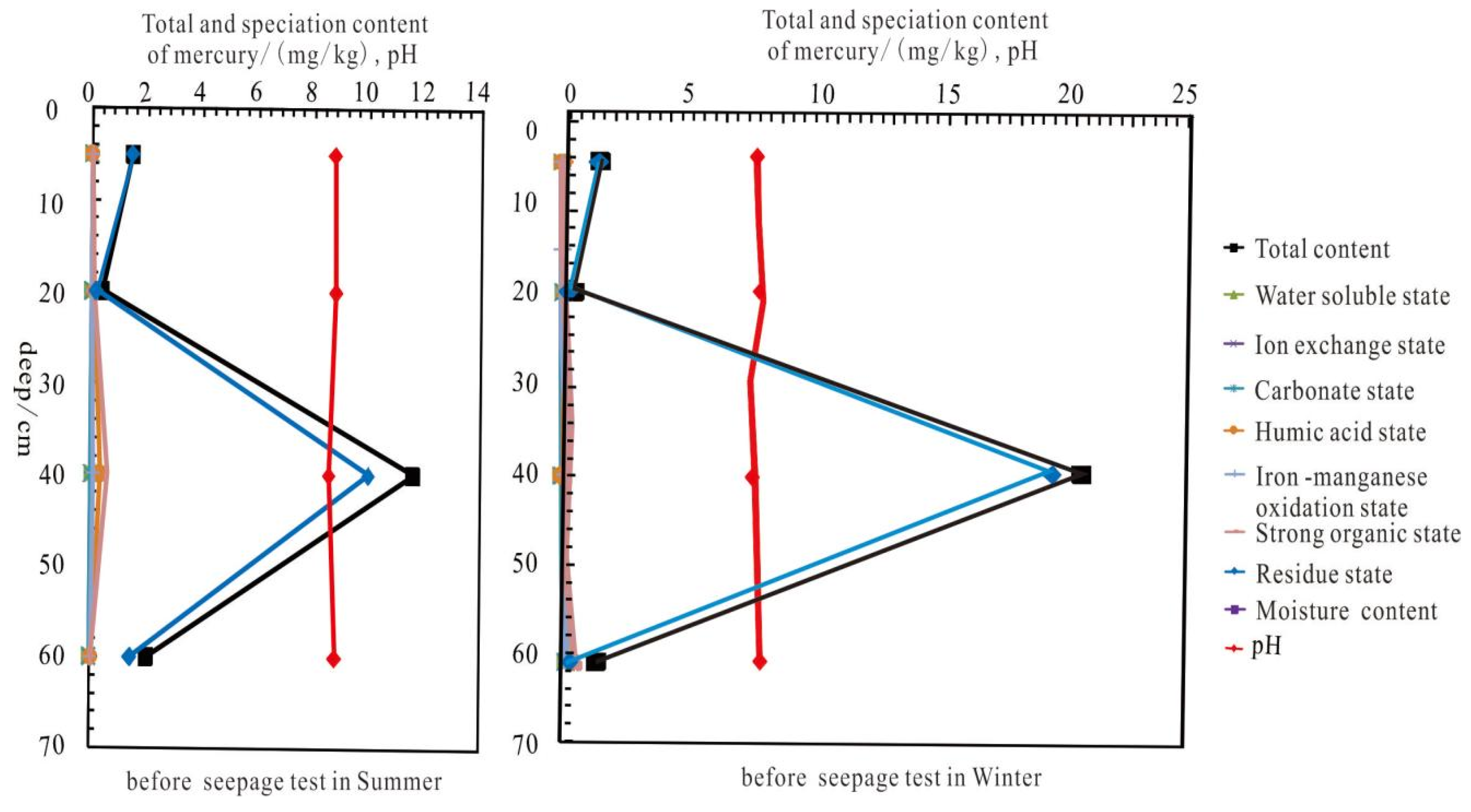
4.1. The Influence of the Occurrence Form and Content of Soil Vertical Hg in the Hyporheic Zone of the Alluvial-Proluvial Area in the High and Low Water Season

It can be seen from Figure 2 that the stable environment of mercury in the undercurrent zone with pH between 8.39–8.87. The mercury forms in the wet and dry periods are mainly in the residual state, indicating that the source of Hg in the undercurrent zone of the gold mining area mainly is the mineral lattice [51], which may be implicated in mining wastewater into the undercurrent zone. The total mercury content (25.22 mg/kg) in the main enriched soil layers in the subsurface in winter was higher than that in summer (11.61 mg/kg). Mercury content displays a negative correlation with pH values. The diagrammatic cross-section in Figure 1e shows that the total amount of mercury in the undisturbed soil and the characteristics of the residue state in the vertical direction of the silt-sand-cobble-tailings-silt-sand-cobble alluvial layer, whether it was the wet season (summer) or the dry season (winter). Furthermore, the high value appears in both 0–10 cm silt containing tailings slag and 30–40 cm silt, however, the highest value is in 30–40 cm silt. In summer, the total and residual contents of mercury in 0–10 cm silt containing tailings were 1.48 mg/kg and 1.45 mg/kg, respectively; the total and residual mercury contents in 30–40 cm silt were 11.64 mg/kg and 10.00 mg/kg, respectively. Kg. Nevertheless, in winter, the total and residual mercury contents in 0–10 cm silt containing tailings are 1.447 mg/kg and 1.445 mg/kg, respectively; the total mercury and residual mercury contents in 30–40 cm sand and pebbles are 19.49 mg/kg and 20.63 mg/kg, to the 40–80 cm sand and pebble layer, this means the total mercury content decreased.

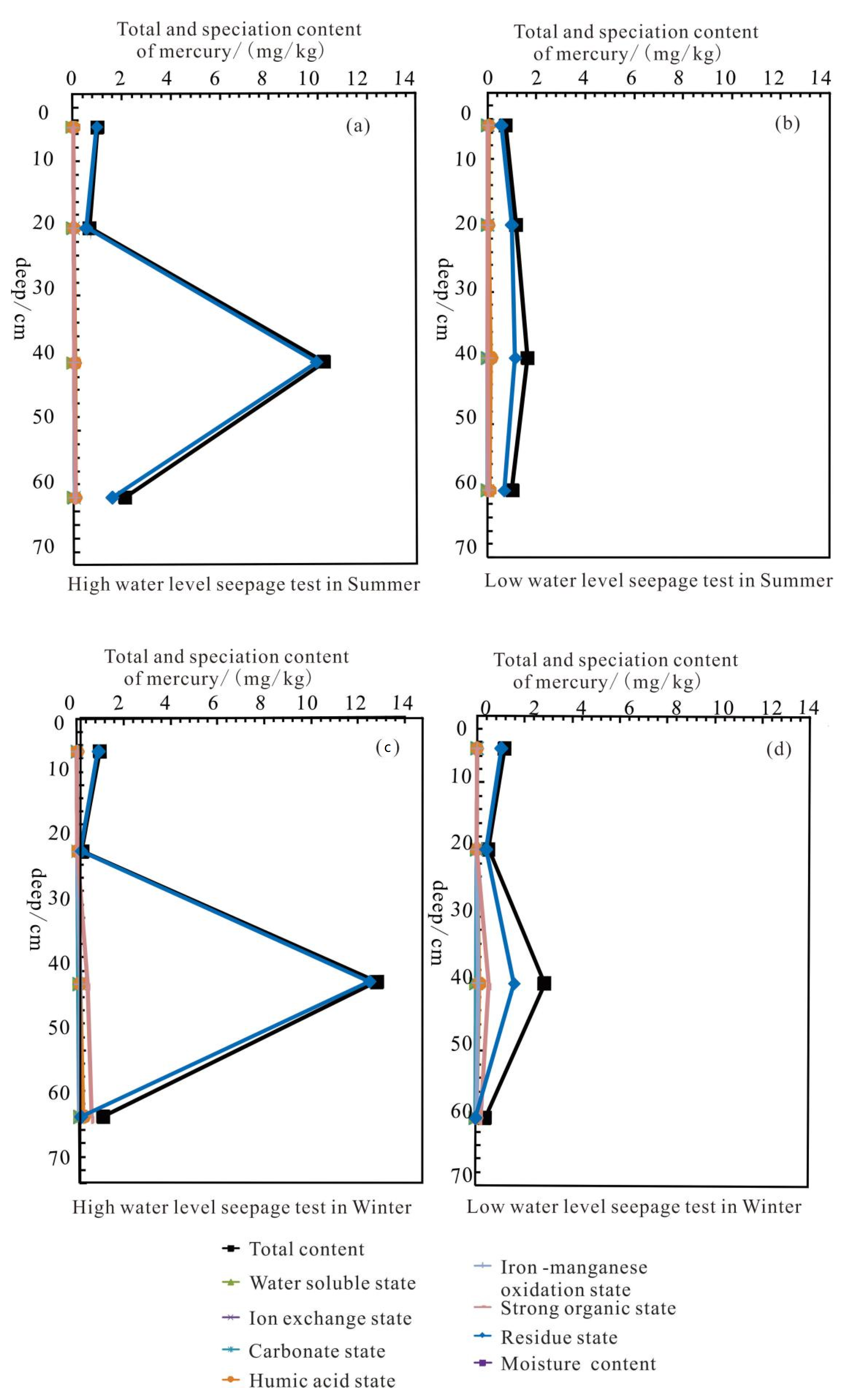
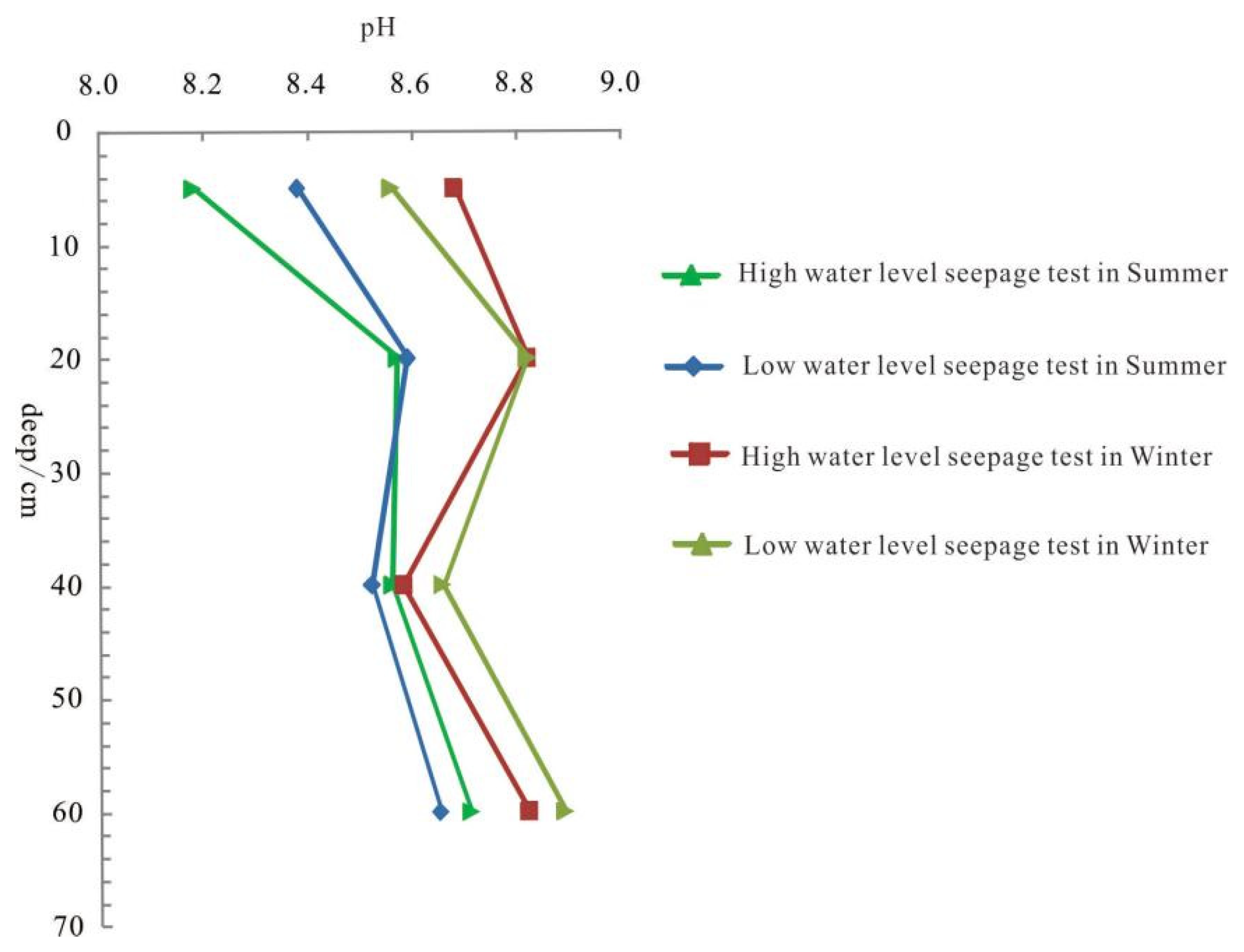
4.2. The Influence of the Occurrence Form and Content of Vertical Hg in the Hyporheic Zone under Different Hydrodynamic Excitation Conditions during High and Low Water Seasons

The morphological characteristics of mercury occurrence of the vertical Hg in the subsurface under high and low water level seepage conditions in wet and dry periods (As shown in Figure 3): the mercury content is still mainly in the residual state, and the highest value is in 30–40 cm silt. Furthermore, the mercury content in the stratum in winter is still higher than that in summer, as well as the total and residual mercury content under high-water seepage conditions is higher than the corresponding mercury content. Whereas the total and residual mercury content in wet 30–40 cm silt sand under high water level seepage conditions is 10.21 mg/kg and 9.91 mg/kg, respectively, while the total amount of mercury in 30–40 cm silt sand under low water level seepage conditions in the wet season and residual state were 1.65 mg/kg and 1.14 mg/kg, respectively. On the other hand, the total amount and residual state of mercury in 30–40 cm silt were 13.02 mg/kg and 12.00 mg/kg, respectively, however, the total amount and residual state of mercury under the condition of high and low water level seepage in the dry season in the 30–40 cm silt under the conditions were 3.01 mg/kg and 2.01 mg/kg (as shown in Figure 4).

5. Discussion

5.1. Factors Affecting Mercury Migration and Transformation

(1) The form of mercury in wet and dry seasons is mainly in the residual state, and the mercury content in the main enriched soil layer in the Hyporheic zone in winter (20.64 mg/kg) and higher than in summer (11.61 mg/kg). The temperature in the wet season is 29–36.9 °C, and the temperature in the dry season is 2–11.5 °C. Moreover, affected by temperature, soil mercury release flux shows that it is restricted by the atmospheric temperature with a positive correlation. The higher the atmospheric temperature, the greater the soil mercury release flux. Even air temperature affects mercury volatilization, but other factors also control soil volatilization, such as humidity, topographical conditions, and meteorology [52].
(2) Under the condition of water seepage, the mercury form changes regardless of the dry or the wet season, the various occurrence forms of 0–30 cm mercury in the vertical direction are decreasing, and still the main one. Nonetheless, in the sand and pebble layer, the main forms of mercury are diversified, including residue state, strong organic state, and humic acid state (see Table 3 and Table 4). Currently, the pH of the layer with the largest change in morphological content also tends to be acidified (as shown in Figure 5). Acidic conditions may increase the content of available mercury in the soil, which leads to an increase in its bioavailability and enhanced migration ability. Adsorption-desorption has a great influence on the migration and transformation process. Occasionally, the influence mechanism of soil pH on the complexation-chelation, oxidation-reduction and methylation reactions in the process of mercury migration and transformation is reflected in ion competitive adsorption, valence state change, and methylation reaction, respectively. and promote the synthesis of factors [53]. The change in humic acid will promote the continuous decrease in water-soluble mercury, exchangeable mercury, and acid-soluble mercury in soil with the increase in alkali-soluble mercury, organically bound mercury and residual mercury [54]. But to the sand pebble layer, this is because in the disturbed system, almost all forms of mercury have mercury release [42].
(3) The convective exchange law of mercury content caused by the pressure gradient in the same layer is reflected in the fact that 0–40 cm does not change significantly after leaching due to the low original content, while the leaching amount of mercury (the amount of mercury leaching under the condition of high-water level seepage at 40 cm) is not obvious. The original value (the mercury content after the water seepage test) is lower than the leaching amount of mercury under low water seepage conditions. The authors believe that the reason is the structure and hydrogeological characteristics of the flow sediments strongly influence the surface and groundwater exchange. Nevertheless, the silt and tailings sand are deposited on the riverbed; in addition, the silts bed has very low permeability and porosity, therefore it also reduces the exchange of undercurrent, and the low permeability rate promotes leaching and water-rocking, and a huge amount of mercury ions and their complexed forms are dissolved out. The inhomogeneous structure of the riverbed also creates effective anisotropy, and it causes restriction of the penetration of solutes, especially in the vertical direction [55]. Salehin et al. [56] conducted a series of experiments on the river-groundwater exchange, and constructed a two-dimensional inhomogeneous riverbed structure by artificial methods. Consequently, he discovered that the water flow prefers to pass through the high permeability area, and the interface flow increases in this area.

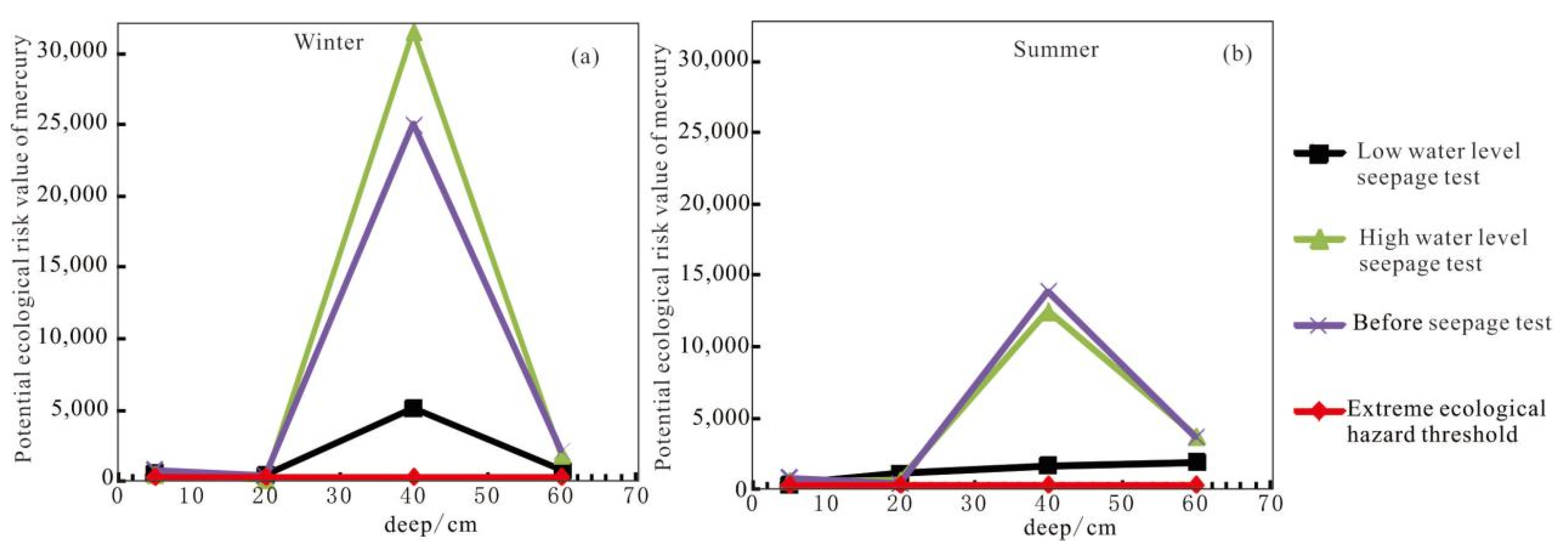
5.2. Potential Ecological Risks

During the history of gold mining areas, there was disorderly and random mining. Consequently, mercury rollers which is a beneficiation process liable to cause mercury pollution are used for illegal gold extraction in the mining valleys in the mountains from the 1990s to around 2010, thus the wastewater was directly discharged into the Shuangqiao River and other rivers with the mine water. Indisputably, it leads to serious ecological problems in rivers. Xu et. al., [57], comparatively investigated four types of soil and water pollution in the study area: atmospheric deposition, river irrigation, mining sewage irrigation, and tailings slag leaching. They summarized that the largest risk is river irrigation type, followed by tailings leaching type [58], and heavy metal elements in river sediments are homologous to those in tailings. As of Table 5 and Figure 5, it can be realized that the potential ecological risk of mercury in the disjointed Hyporheic zone is much higher than the extreme ecological hazard with a threshold (320), regardless of whether the hydraulic connection is in winter or summer, and the maximum risk of mercury in the original soil layer in winter and summer reaches 25,005.5 and 13,886.48, respectively, 78.14 and 43.40 times of the extreme ecological hazard threshold. Likewise, the pollution risk of 30–50 cm sand and pebble are the greatest, while the ecological risk of 0–30 cm silt layer and waste residue layer is relatively small. After leaching, the potential ecological risk of mercury in most soil layers in the Hyporheic zone has been reduced, especially after leaching at a constant water level. On the other hand, the risk value of the sand and pebble layer in winter has dropped from the original 25,005.5 to 5133, and the risk value of the sand and pebble layer in winter has been reduced from the original. Moreover, 13,886.48 dropped to 1656.07, which means that mercury entered the groundwater body. When a flood occurs (within 30 min), the mercury content in the surface layer decreases rapidly, attributable to many influencing factors described above, which produce an increase in the sand and pebble layer below (changed to 31,525); in addition, the potential ecological risk of mercury in the soil layer under normal water level leaching decreased, increasing the ecological risk of groundwater.

6. Conclusions

The form of mercury in the undercurrent zone where the river water-groundwater hydraulic connection is disconnected from the gold mining area is mainly in the residual state. Nonetheless, after the water content increases or the water level changes, creates variation in the occurrence forms of mercury are all decreasing, and the residual form is still the main form, whereas the main forms of mercury in the sand and pebble layer are diversified, but also including residual form, strong organic form, and humic acid form. This facilitates the entry of mercury into water bodies. The mercury content in the subsurface in winter is higher than that in summer. Relevant departments should monitor heavy metal pollution in groundwater and Hyporheic zones in different seasons.
Although the mercury content in groundwater has not been detected, the potential ecological risk of mercury in the disjointed Hyporheic zone near the river in the study area has reached an extreme ecological hazard. In a short 30-min constant water level leaching test, the potential risk of mercury to groundwater is higher. Furthermore, during the flood period, the long-term runoff of rivers at a constant water level is bound to pose a greater risk of groundwater pollution. Consequently, the following measures can be taken: (1) control the sources of heavy metals at source, (2) reduce the ecological risks of heavy metals to groundwater by physical chemistry, bioremediation and pesticide control in soil as soon as possible on the basis of river regulation.

Author Contributions

R.L., F.L. and J.J. wrote this manuscript. R.L. conceives the original idea of this study. E.-W.R.M. polished this manuscript. All authors (R.L., F.L., J.J., Y.X., Y.D., E.-W.R.M., X.Z. and H.C.) modified the manuscript. Authorship must be limited to those who have contributed substantially to the work reported. All authors have read and agreed to the published version of the manuscript.

Funding

This research was funded by the survey projects initiated by the Ministry of Natural and Resources of the People’s Republic of China (DD20211317, DD20189220, 1212010741003,1212011220224, and 121201011000150022), the public welfare scientific research project launched by the Ministry of Natural and Resources of the People’s Republic of China (201111020), the project of 2015 Natural Science Basic Research Program of Shaanxi (2015JM4129), and the project of 2016 Fundamental Research Funds for the Central Universities (open fund) (310829161128). Formation of extensional crenulation cleavage in the ductile of Xiaoqinlin Metamorphic Core Complex (2021KJXX-73), A research on intelligent sensing, coupling evolution and driving mechanism of mine geological environment The authors ’thanks also go to the experiment and testing lab of Xi’an Center, China Geological Survey for the statistical analysis of the data conducted.

Conflicts of Interest

The authors declare no conflict of interest.

References

  1. White, D.S. Perspectives on defining and delineating hyporheic zones. J. N. Am. Benthol. Soc. 1993, 12, 61–69. [Google Scholar] [CrossRef]
  2. Stanford, J.A.; Ward, J.V. The hyporheic habitat of river ecosystems. Nature 1988, 335, 64–66. [Google Scholar] [CrossRef]
  3. Biddulph, M. Chapter: 3.11.1: Hyporheic Zone. In Situ Sampling; Cook, S.J., Clarke, L.E., Nield, J.M., Eds.; Geomorphological Techniques (Online Edition); British Society for Geomorphology: London, UK, 2015; ISSN 2047-0371. [Google Scholar]
  4. Triska, F.J.; Kennedy, V.C.; Avanzino, R.J. Retention and transport of nutrients in a third- order stream in northwestern California: Hyporheic processes. Ecology 1989, 70, 1893–1905. [Google Scholar] [CrossRef]
  5. Elliott, A.H.; Brooks, N.H. Transfer of nonsorbing solutes to a streambed with forms: Theory. Water Resour. Res. 1997, 33, 123–136. [Google Scholar] [CrossRef]
  6. Kasahara, T.; Wondzell, S.M. Geomorphic controls on hyporheic exchange flow in mountain streams. Water Resour. Res. 2003, 39, 1–14. [Google Scholar] [CrossRef]
  7. Wondzell, S.M. Effect of morphology and discharge on hyporheic exchange flows in two small streams in the Cascade Mountains of Oregon, USA. Hydrol. Processes 2006, 20, 267–287. [Google Scholar] [CrossRef]
  8. Boulton, A.J. Hyporheic rehabilitation in rivers: Restoring vertical connectivity. Freshw. Biol. 2007, 52, 632–650. [Google Scholar] [CrossRef]
  9. Zhang, L.; Li, P.; He, X. Interactions between surface water and groundwater in selected tributaries of the Wei River (China) revealed by hydrochemistry and stable isotopes. Hum. Ecol. Risk Assess. 2022, 28, 79–99. [Google Scholar] [CrossRef]
  10. Singh, M.; Ansari, A.A.; Muller, G.; Singh, I.B. Heavy metals in freshly deposited sediments of the Gomati River (a tributary of the Ganga River) effects of human activities. Environ. Geol. 1997, 29, 246–252. [Google Scholar] [CrossRef]
  11. Calmano, W.; Ahlf, W.; Forstner, U. Exchange of Heavy Metals Between Sediment Components and Water. In Metal Speciation in the Environment; Springer: Berlin/Heidelberg, Germany, 1990; pp. 503–522. [Google Scholar]
  12. Batley, G.E. Trace Element Specification: Analytical Methods and Problems; CRC Press: Boca Raton, FL, USA, 2000; ISBN 9780849347122. [Google Scholar]
  13. Altın, A.; Filiz, Z.; Iscen, C.F. Assessment of seasonal variations of surface water quality characteristics for Porsuk Stream. Environ. Monit. Assess. 2009, 158, 51–65. [Google Scholar] [CrossRef]
  14. Muhammad, S.; Shah, M.T.; Khan, S. Heavy metal concentrations in 845 soil and wild plants growing around Pb-Zn sulfide terrain in the Kohistan region, northern Pakistan. Microchem. J. 2011, 99, 67–75. [Google Scholar] [CrossRef]
  15. Sun, Z.; Mou, X.; Tong, C.; Wang, C.; Xie, Z.; Song, H.; Sun, W.; Lv, Y. Spatial variations and bioaccumulation of heavy metals in intertidal zone of the Yellow River estuary, China. Catena 2015, 126, 43–52. [Google Scholar] [CrossRef]
  16. Younger, P.L.; Banwart, S.A.; Hedin, R.S. Mine Water: Hydrology, Pollution, Remediation; Kluwer Academic Publishers: London, UK, 2002; 442p. [Google Scholar]
  17. Stamatis, G.; Voudouris, K.; Karefilakis, F. Groundwater pollution by heavy metals in historical mining area of Lavrio, Attica, Greece. Water Air Soil Pollut 2001, 128, 61–83. [Google Scholar] [CrossRef]
  18. Bird, G.; Macklin, M.G.; Brewer, P.A.; Zaharia, S.; Balteanu, D.; Driga, B.; Serban, M. Heavy metals in potable groundwater of mining-affected river catchments, northwestern Romania. Env. Geochem. Health 2009, 31, 741–758. [Google Scholar] [CrossRef] [PubMed]
  19. Al-Hobaib, A.S.; Al-Jaseem QKh Baioumy, H.M.; Ahmed, A.H. Heavy metals concentrations and usability of groundwater at Mahd Adh Dhahab gold mine, Saudi Arabia. Arab. J. Geosci. 2013, 6, 259–270. [Google Scholar] [CrossRef]
  20. Liu, Q.J.; Huang, Y.; Hu, S.Y.; Deng, K.W.; Huang, D.; Cao, L. Chemical Forms of Hg, Pb, Cd, Cu and Zn in Beijing Urban Soil and Its Environmental Effects. Urban Geol. 2015, 10, 11–15. [Google Scholar]
  21. Clifton, J.C., 2nd. Mercury exposure and public health. Pediatr. Clin. N. Am. 2007, 54, 237–269. [Google Scholar] [CrossRef]
  22. US Department of Health and Human Services, Public Health Service. Toxicological Profile for Mercury; US Department of Health and Human Services: Atlanta, GA, USA, 1999; pp. 1–600. [Google Scholar]
  23. Rice, G.E.; Ambrose, R.B., Jr.; Bullock, O.R., Jr.; Smawtout, J. Mercury Study Report to Congress; US Environmental Protection Agency: Durham, NC, USA, 1997; pp. 1.1–6.30. [Google Scholar]
  24. Marcello, M.; Veiga, O.F. A review of the failed attempts to curb mercury use at artisanal gold mines and a proposed solution. Extr. Ind. Soc. 2020, 7, 1135–1146. [Google Scholar]
  25. Mantey, J.; Nyarko, K.B.; Owusu-Nimo, F.; Awua, K.A.; Bempah, C.K.; Amankwah, R.K.; Akatu, W.E.; Appiah-Effah, E. Mercury contamination of soil and water media from different illegal artisanal small-scale gold mining operations (galamsey). Heliyon 2020, 6, 1–13. [Google Scholar] [CrossRef]
  26. Goldman, L.R.; Shannon, M.W. American Academy of Pediatrics: Committee on Environmental Health. Technical report: Mercury in the environment: Implications for pediatricians. Pediatrics 2001, 108, 197–205. [Google Scholar] [CrossRef]
  27. Harada, M.; Nakachi, S.; Cheu, T.; Hamada, H.; Ono, Y.; Tsuda, T.; Yanagida, K.; Kizaki, T.; Ohno, H. Monitoring of mercury pollution in Tanzania: Relation between head hair mercury and health. Sci. Total Environ. 1999, 227, 249–256. [Google Scholar] [CrossRef]
  28. Guzzi, G.; La Porta, C.A. Molecular mechanisms triggered by mercury. Toxicology 2008, 244, 1–12. [Google Scholar] [CrossRef] [PubMed]
  29. Ma, W.B.; Chen, Q.Y.; Yin, D.L.; Sun, T.; Wang, Y.M.; Wang, D.Y. Temporal and Spatial Variation of Mercury in the Water of the Ruxi River Estuary, a Typical Tributary of the Three Gorges Reservoir Area. Environ. Sci. 2019, 40, 2211–2218. [Google Scholar]
  30. Zhang, Y.F. Study on Migration Mechanism of Lead in Undulating Zone of Groundwater. Master’s Thesis, North China University of Water Resources and Hydropower, Zhengzhou, China, 2021. [Google Scholar]
  31. Xiong, J.Q. Study on the Effect of DOM on the Bioavailability of Heavy Metals under Poyang Lake Water Level. Master’s Thesis, Nanchang University, Nanchang, China, 2021. [Google Scholar]
  32. Wang, P.A. Dynamic Variation of Mercury Species in Soil in Wet-Dry Rotation Environment. Master’s Thesis, Southwest University, Chongqing, China, 2007. [Google Scholar]
  33. Tang, X.C.; Lin, T.; Xia, P.H.; Huang, X.F.; Ma, L.; Yang, Y. Speciation distribution and risk assessment of Hg and As in sediment of Lake Caohai wetlands under different water level gradionts, Guizhou Province. J. Lake Sci. 2020, 32, 100–110. [Google Scholar]
  34. Zhang, C.; Chen, H.; Sun, R.G.; Zhang, X.; Wang, D.Y. Risk Assessment of Mercury in Soil at Different Water-level Altitudes in Drawdown Areas of Three Gorges Reservior. J. Soil Water Conserv. 2014, 28, 0242–0246. [Google Scholar]
  35. Wu, Z.R. Experimental Study on the Vertical Migration of Typical Heavy Metals from the Saturated Zone to Hyporheic zone. Master’s Thesis, Hefei University of Technology, Hefei, China, 2020. [Google Scholar]
  36. Tian, Y.; Yang, W.C. Analysis on Migration of Heavy Metals in Groundwater Fluctuation Zone. Environ. Sci. Manag. 2020, 44, 40–44. [Google Scholar]
  37. Li, Y.; Li, P.; Liu, L. Source Identification and Potential Ecological Risk Assessment of Heavy Metals in the Topsoil of the Weining Plain (Northwest China). Expo. Health 2022, 14, 281–294. [Google Scholar] [CrossRef]
  38. Liu, Y.; Zhao, J.E.; Zhang, F.S. Pollution status and potential ecological risk assessment of heavy metals in the surface sediments of Qingdao intertidal zone. Environ. Pollut. Control 2021, 43, 492–501. [Google Scholar]
  39. Dai, Q. Environmental geochemistry study of mercury contamination from gold mining areas by amalgamation technique in China—a case study from Tongguan county of Shaanxi Province. Master’s Thesis, Institute of Geochemistry, Chinese Academy of Sciences, Beijing, China, 2004. [Google Scholar]
  40. Xu, Y.N.; Ke, H.L.; Zhao, A.I. Assessment of heavy metals contamination of farmland soils in some gold mining area of Xiao Qinling. Chin. J. Soil 2007, 4, 24. [Google Scholar]
  41. Jiang, N.; Xu, J.; Song, M. Fluid inclusion characteristics of mesothermal gold deposits in the Xiaoqinling district, Shaanxi and Henan Provinces, People’s Republic of China. Min. Depos. 1999, 34, 150–162. [Google Scholar]
  42. Liu, R.P.; Xu, Y.N.; Rui, H.C.; El-Wardany, R.M.; Ying, D. Migration and speciation transformation mechanisms of mercury in undercurrent zones of the Tongguan gold mining area, Shaanxi Loess Plateau and impact on the environment. China Geol. 2021, 4, 311–328. [Google Scholar]
  43. Xiao, R.; Wang, S.; Li, R.H.; Wang, J.J.; Zhang, Z.Q. Soil heavy metal contamination and health risks associated with artisanal gold mining in Tongguan, Shaanxi, China. Ecotoxicol. Environ. Saf. 2017, 141, 17–24. [Google Scholar] [CrossRef] [PubMed]
  44. Xu, Y.N.; Zhang, J.H. Contents of heavy metals in bottom sediments of the Taiyu River in the Tongguan gold mining ar ea, Shaaxi, China, and contamination assessments. Geol. Bull. China 2008, 27, 1263–1671. [Google Scholar]
  45. Li, G.; Lu, N.; Wei, Y.; Zhu, D.W. Relationship between Heavy Metal Content in Polluted Soil and Soil Organic Matter and pH in Mining Areas. IOP Conf. Ser. Mater. Sci. Eng. 2018, 394, 052081. [Google Scholar] [CrossRef]
  46. Wu, Y.; Xu, Y.; Zhang, J.; Hu, S.; Liu, K. Heavy metals pollution and the identification of their sources in soil over Xiaoqinling gold-mining region, Shaanxi, China. Environ. Earth Sci. 2011, 64, 1585–1592. [Google Scholar] [CrossRef]
  47. Li, Z.; Liu, G.J.; Shen, M.C.; Liu, Y. Potential ecological and health risks of heavy metals for indoor and corresponding outdoor dust in Hefei. Cent. China. Chemosphere 2022, 302, 134864. [Google Scholar]
  48. Hakanson, L. An Ecological risk index for quality pollution control:a sedimentological approach. Water Res. 1980, 14, 975–1001. [Google Scholar] [CrossRef]
  49. Zhao, A.N. The Assessment of Contamination And Corerlation on Heavy Metal between Farmland and Crops in Tongguan Gold Mining Area in Shaanxi. Master’s Thesis, Chang’an University, Xi’an, China, 2006; pp. 1–73. [Google Scholar]
  50. Wang, X.W. The Research about the Relationship between Heavy metals contamination and Crops on farmland soi1 in the Goldfield. Master’s Thesis, Chang’an University, Xi’an, China, 2010; pp. 1–84. [Google Scholar]
  51. Zhou, Y.; Wang, X.M.; Jiang, Y.Z.; Zhao, Y.F.; Ji, H.B. Speciation and ecological risk assessment of arsenic and mercury in soil around a gold mining area in pinggu district, beijing. Environ. Eng. 2021, 39, 164+204–210. [Google Scholar]
  52. Liu, R.P.; Xu, Y.N.; Zhang, J.H. The Relationship and Influencing Factors of Water-Gas Interface Mercury Emission Flux and Water Suspended Mercury of a Gold Mining Area River. In Sustainable Development of Water Resources and Hydraulic Engineering in China; Springer Cham: Cham, Switzerland, 2016. [Google Scholar]
  53. Dong, W.; Lian, Y.Q.; Zhang, Y. (Eds.) Environmental Earth Sciences; Springer Science+Business Media: Berlin, Germany, 2018; Volume 35, pp. 407–415. [Google Scholar]
  54. DOU, W.Q.; Yi, A.N.; Li, Q.; Zeng, Q.N. Xia, Q. Research progress on effects of soil pH on migration and transformation of mercury. J. Agric. Resour. Environ. 2019, 36, 1–8. [Google Scholar]
  55. Ran, M.X.; Yang, H.Y.; Huang, J.Y.; Li, Z.; Chen, Y.; Feng, Q.Z.; Li, Y.; Liu, L.Y. Effect of humic acids on the mercury speciation in soils of Wanshan area in Guizhou Province. J. Anhui Agric. Univ. 2020, 47, 95–102. [Google Scholar]
  56. Guang, Q.; Li, L. Advancement in the hyporheic exchange in rivers. Adv. Water Sci. 2008, 19, 285–293. [Google Scholar]
  57. Salehin, M.; Packman, A.; Paradis, M. Hyporheic exchange with heterogeneous streambeds: Laboratory experiment sand modeling. Water Resour. 2004, 40, W11504. [Google Scholar]
  58. Xu, Y.N.; Zhang, J.H.; Chen, S.B.; Ke, H.L. Distribution of Contents of Heavy Metals in Soil Profile Contaminated in Different Ways in Xiaoqinling Gold Mining Area. J. Agro-Environ. Sci. 2008, 27, 0200–0206. [Google Scholar]
Figure 1. (a) view of a river shows the position of the hyporheic zone. (b) the directional flow of water through the hyporheic zone. (after [2,3]), (c) location map of the study area. (d) The map of the sample and its landscape distribution after [9]. (e) Distribution of water seepage test.
Water 14 02950 g001
Figure 2. Occurrence forms of mercury in the soil layer of the vadose zone before the water seepage test was performed in the dry and wet periods.
Water 14 02950 g002
Figure 3. Characteristics of mercury transport in the subsurface under different hydrodynamic excitation conditions in wet and dry periods.
Water 14 02950 g003
Figure 4. Characteristics of pH transport in the subsurface under different hydrodynamic excitation conditions in wet and dry periods.
Water 14 02950 g004
Figure 5. Line chart of potential ecological risks of mercury in the subsurface under changing river water levels. (a)—The line chart of the ecological risk of mercury in the subsurface under the condition of changing river water level in winter; (b)—The line chart of the ecological risk of mercury in the subsurface under the condition of changing the river water level in winter.
Water 14 02950 g005
Table 1. Toxicity coefficients of Hg and its reference values.
DepthTC0 (mg/kg)
0–20400.070
20–30400.036
30–50400.032
50–70400.018
Table 2. Potential ecological risk coefficient and classification of ecological risk degree.
Potential Ecological Hazard
Coefficient (EHg)
Potential Ecological Risk
Degree Grading
<40Mild ecological hazard
40–80Moderate ecological hazard
80–160Intensity Ecological Hazard
160–320Very high ecological hazard
>320Extremely ecologically hazardous
Table 3. List of mercury speciation content and its percentage in subsurface flow zone in the dry season.
Different Hydrodynamic Excitation Sample No.pHMoisture ContentThe Hg Speciation ContentThe Percentage of Hg Speciation Content in the Total Amount
TotalWater Soluble StateIon Exchange StateCarbonate State Humic Acid StateHumic Acid StateIron-Manganese Oxidation
State
Strong Organic
State
Residue
State
Water Soluble StateIon Exchange StateCarbonate State Humic Acid StateHumic Acid StateIron Manganese Oxidation
State
Strong Organic
State
Residue
State
%mg/kgmg/kgmg/kgmg/kgmg/kgmg/kgmg/kgmg/kg%%%%%%%
Low water level infiltration testdd-18.568.671.0380.0010.0020.0050.0100.0080.0031.0090.090.190.500.920.780.2997.24
dd-28.8216.520.4230.0010.0010.0020.0050.0040.0030.4070.200.250.561.240.980.6096.17
dd-38.4911.394.1060.0080.0050.0080.2450.0860.5623.1940.190.110.185.962.0813.6977.78
dd-48.893.240.3550.0100.0010.0010.0540.0450.2260.0182.810.320.3715.0912.6363.824.95
High water level infiltration testgd-18.688.30.9230.0010.0010.0060.0030.0030.0040.9040.130.140.670.340.280.4497.99
gd-28.8212.140.1520.0010.0010.0020.0020.0020.0030.1410.390.671.181.231.282.2293.02
gd-38.3517.2625.2200.0140.0200.0180.0240.1430.37624.6260.050.080.070.100.571.4997.64
gd-48.824.820.8530.0280.0020.0020.1840.0100.5470.0813.310.180.1821.591.2164.089.44
Befurer infiltration testyd-18.759.11.4730.0020.0020.0020.0040.0040.0111.4490.110.160.110.260.270.7498.34
yd-28.815.480.3670.0000.0010.0020.0830.0060.1140.1620.110.280.4422.451.6330.9144.18
yd-38.3912.5520.0040.0110.0260.0120.0370.1390.28519.4940.050.130.060.180.701.4397.45
yd-48.785.570.9700.0560.0020.0020.2170.0150.5210.1585.710.210.1622.391.5453.7016.29
Table 4. List of mercury speciation content and its percentage in subsurface flow zone in the wet season.
Different Hydrodynamic ExcitationSample No.pHMoisture ContentThe Hg Speciation ContentThe Percentage of Hg Speciation Content in the Total AmountDifferent Hydrodynamic Excitation Sample No.pHMoisture ContentThe Hg Speciation ContentThe Percentage of Hg Speciation Content in the Total AmountDifferent Hydrodynamic Excitation Sample No.pHMoisture ContentThe Hg Speciation ContentThe Percentage of Hg Speciation Content in the Total AmountDifferent Hydrodynamic Excitation
Different Hydrodynamic ExcitationSample No.pHMoisture Content TotalIon Exchange StateCarbonate State Humic Acid StateHumic Acid StateIron-Manganese Oxidation
State
TotalWater Soluble StateIon Exchange StateCarbonate State Humic Acid StateHumic Acid State TotalResidue
State
%mg/kgmg/kgmg/kg %mg/kgmg/kg% %mg/kgmg/kg%
Low water level infiltration testdd- 18.389.980.6250.0010.0010.0010.0540.0070.0050.5550.210.190.218.701.170.7588.77
dd- 28.5910.041.0420.0010.0010.0010.0410.0060.0030.9870.140.110.133.970.590.3194.75
dd- 38.5212.911.3250.0020.0010.0010.1600.0040.0121.1450.140.080.0912.100.320.8786.39
dd- 48.6510.600.8680.0020.0010.0010.0990.0120.0440.7080.280.140.1311.381.435.0581.59
High water level infiltration testgd- 18.1812.581.0290.0010.0010.0010.0330.0050.0040.9840.140.120.123.200.450.4095.58
gd- 28.5713.160.5770.0020.0010.0010.0330.0030.0090.5280.300.210.215.700.571.5291.48
gd- 38.5612.779.9860.0020.0010.0010.0570.0070.0039.9140.020.010.010.570.070.0399.27
gd- 48.7112.581.6820.0020.0010.0010.0600.0070.0481.5630.130.070.083.570.422.8492.90
Befurer infiltration testyd-18.759.101.4740.0020.0020.0020.0040.0040.0111.4490.110.160.110.260.270.7498.87
yd-28.8010.480.3680.0000.0010.0020.0830.0060.1140.1620.110.280.4422.451.6330.9144.18
yd-38.5912.1511.1090.0420.0150.0070.3360.1100.59610.0030.380.140.063.030.995.3790.04
yd-48.824.241.6500.0230.0040.0040.0520.0370.0641.4661.390.250.223.122.233.9188.88
Table 5. The potential ecological risk value of mercury in the subsurface zone under the condition of changing river water level.
SeasonDepth (cm)The Potential Ecological
Risk Value of Mercury
after Seepage Test
The Potential Ecological
Risk Value of Mercury
before Water Seepage Test
Low Water LevelHigh Water LevelOriginal Stratigraphic Section
Winter0–20592.91527.2841.94
20–30470.22168.56408.11
30–5051333152525005.5
50–70788.671896.442156.22
Summer0–20357.26588.13842.19
20–301157.3641.64408.59
30–501656.0712,482.7113,886.48
50–701927.793737.813666.46
Publisher’s Note: MDPI stays neutral with regard to jurisdictional claims in published maps and institutional affiliations.

