
Geomorphology of the Po Fluvial Terraces in Turin Deduced by New Subsoil Data (NW Italy)

Department of Earth Sciences, University of Turin, 10125 Torino, Italy
*
Author to whom correspondence should be addressed.
Water 2022, 14(18), 2872; https://doi.org/10.3390/w14182872
Submission received: 30 July 2022
/
Revised: 3 September 2022
/
Accepted: 8 September 2022
/
Published: 14 September 2022
(This article belongs to the Special Issue Fluvial Geomorphology, River Management and Restoration)
Abstract
:Urban geomorphology is a theme of increasing interest over the last decades. The present research about the Turin geomorphology (NW Italy) was carried out based on the drilling of 40 boreholes, of which 34 were designed for the construction of a new sewer collector by SMAT-Società Metropolitana Acque Torino, while other 6 were in the Valentino Park. These investigations allow us to evaluate the detailed morphology of the proglacial plain of the Rivoli-Avigliana end-moraine system (RAES) and facies, thickness and petrographic composition of fluvial sandy gravel forming this plain (Turin Unit). The local discovery of a truncated palaeosol suggests that this unit lies on a significant erosional surface shaped on more ancient fluvial sediments. New radiocarbon dating of woody macrorest above the palaeosol proves the Last Glacial Maximum (LGM) age of the Turin Unit. The same investigations suggest the presence of erosional terraces (Molinette T1 and Murazzi T2), shaped by the Po River in the proglacial sediments, and depositional terraces (Vallere T3 and Parco Stura T4), which are essentially formed by sand. Dating of woody macrorest confirms the widespread presence of RAES Late Pleistocene proglacial sediments and the subsequent entrenched Po fluvial terraces due to a significant Holocene fluvial deviation.
1. Introduction
The urban context of a plain is difficult to study due to the lack or scarcity of natural outcrops, which does not allow for a geological survey to be carried out using classical methods [1,2,3,4,5,6]. This lack is only partially mitigated by the excavation of ephemeral outcrops located on building sites and natural outcrops along the fluvial incisions [7]. Despite this, the reconstruction of an urban subsoil is also very useful for considering any interventions in the territory in advance [8,9].
Turin (NW Italy), in the Western Po Plain, extends over an area of 130 km2, most of which comprises inhabited sectors (105 km2, 80% of the Turin area) situated on a terraced fluvial plain at 275–210 m a.s.l. This plain consists of the distal sector of the wide Dora Riparia proglacial fans downstream of the Rivoli-Avigliana end-moraine system (RAES) [10].
This sector is closely surrounded by the Western Alps (up to 3538 m of the M. Rocciamelone and 3611 m of the Pointe de Ronce), based on the metamorphic bedrock, and by the Turin Hill (up to 715 m a.s.l.), based on a Cenozoic marine sedimentary succession, on which there extends a less dense suburb (20% of the Turin area) (Figure 1).
Turin is characterized by significant watercourses since, it is intersected by the largest river in Italy (Po River) in the SSW–NNE direction and by three main tributaries (from south to north: the Sangone, Dora Riparia and Stura di Lanzo rivers), which flow east. These rivers are supplied by the Western Alps, which rise not far from the western sector of Turin (the closest is 15 km from the outlet of the Susa Valley). Furthermore, about ten short creeks flow from the Turin Hill, located immediately east of Turin (up to 715 m a.s.l.).
The installation project of the new sewer collector in the Turin Plain by the Società Metropolitana Acque Torino (SMAT) resulted in the drilling of 34 geognostic boreholes, with continuous sampling at a depth ranging from 15 to 35 m, located in the eastern sector of Turin near the Po River. The boreholes recently drilled in the Valentino Park, designed for the extension of the existing buildings, also supplied new, useful data. The chance to directly examine the cores of numerous boreholes offered a good opportunity for the advancement of knowledge about the shallow subsoil sediments of Turin. The study of these cores, in addition to previous data and recent geological mapping [7,11], allowed us to reconstruct the geometries and features of the fluvial sedimentary bodies in the distal sector of the proglacial outwash plain, on which Turin is built.
The new sewer median collector (Figure 1), whose set location is very close to the existing one, constitutes a significant infrastructural feature for Turin. It represents a functional response to new emergencies due to climate change, which can create high hydraulic overload caused by the increase in mixed water during heavy rainfall. Specifically, this infrastructure will allow rainwater to be conveyed and sent for treatment in the SMAT purification plant of Castiglione Torinese, especially the first rainwater, which is particularly rich in pollutants following periods of drought.
The installation of the new collector will be carried out along a stretch of approximately 14.4 km in the territory of the Municipality of Turin and its neighboring areas. The main collector tunnel will have a diameter of 3.2 m and will be built using tan automatic tunnel boring machine (TBM) with a 4.1 m-diameter drill bit. The automatic mole, while digging, will simultaneously construct the tunnel structure, for which 23,000 concrete segments will be used.
Approximately 250,000 m3 of dumping materials will be sent to a landfill. The TBM starting point will be a 13,000 m2 yard at the northern edge of Turin (near boreholes PES 30 and PES 32 on Figure 2). An automated transfer system of the segments will be provided by rail wagons along a 9 km-long tunnel.
2. Methods
The cores of 34 geognostic boreholes, drilled in 2020 along the new SMAT sewer collector area, were carefully studied in addition to the direct observation of another 6 cores from previous drillings conducted in 2019 near the Valentino buildings (the black numbers in Figure 2). Many of the borehole logs published on [12] were also used to integrate the subsoil reconstruction (the blue points in Figure 2).
The location of the ARPA and Valentino boreholes have already been reported on the geological map of the Turin Po River terraces [11] and situated on the Carta Tecnica Regionale (CTR) at the 1:10,000 scale of the Regione Piemonte. In the present work, the mapping is based on the updated BDTRE topographic map of the Regione Piemonte, which differs in its elevation a.s.l., being up to 2–3 m lower than the CTR map.
The Quaternary fluvial succession of this area was divided into several stratigraphic units using allostratigraphic and morphostratigraphic methods. These units are usually made up of fluvial sediments forming depositional terraces, referred to as unconformity boundary stratigraphic units (UBSU), but they can also be sediment-free landforms (erosional terraces), defined as morphological units [13].
A new detailed stratigraphic description and interpretation of the cores was conducted, though the cores were already given a summary description, written by the site geologist. This new interpretation was also formed in order to standardize the stratigraphic descriptions and facilitate the geological reading of the boreholes. The logs were depicted in a detailed subsoil sediment reconstruction and used for drawing the cross-sections. The different units were defined according to the sedimentary facies of the deposits, soil weathering degree and associated terrace morphology (elevation, lateral continuity and morphology). The colors of the soils and sediment matrix were detected by means of the Munsell Soil Color Chart. A petrographic analysis of the clasts on numerous gravel levels was also performed, obtaining the percentage of the various lithotypes forming the pebbles, with the aim of reconstruct the feeding basins, especially through the use of the presence or absence of marker lithologies.
Ten organic samples (eight woody macrorests, one carbon and one gyttja) were collected from five cores (PESC 03, PES 09bis, PES 12, VAL 74 and PES 17). Radiocarbon AMS (accelerated mass spectrometry) dating was carried out by the Laboratory of Ion Beam Physics, ETH Zürich. The radiocarbon ages were calibrated using the IntCal20 atmospheric calibration dataset [14] with a 2σ range and the OxCal v4.4.4 program [15].
The main difficulty encountered during this research arose due to the thick landfill cover, which can be connected to the anthropic reshaping of the original landscape and reworking of sediments in the urban environment. The identification of thick anthropic sediments in numerous investigated boreholes allowed us to modify the previous mapping, which was essentially based on morphological data and the local occurrence of outcrops.
3. Geological Setting
The shallow subsoil of Turin is characterized by a relatively thin cover of Quaternary fluvial sediments (10–30 m) that lie on a tertiary marine sedimentary succession consisting of various synthems, ranging from Eocene to Pliocene and bound by key erosional unconformities. The oldest part of this succession (upper Eocene-Messinian) is referred to as the Tertiary Piedmont Basin (TPB) outcropping, situated in the wide Piedmont hilly system (i.e., Monferrato, Langhe and the Turin Hill).
The TPB consists of two Late Eocene to Early Miocene terrigenous synthems (conglomerate, sandstone and marl), a Burdigalian carbonate synthem and two Langhian to Tortonian terrigenous synthems (marl, sandstone, conglomerate and clay), which are buried by Messinian evaporite [15,16,17,18]. East of Turin, this succession gives rise to an asymmetrical anticline with a SW–NE axis (Turin Hill). This NW-verging structure overthrusts the Po Plain foredeep along the Padane Thrust Front (Figure 3), buried by the fluvial sediments forming the Turin Plain [19,20].
The more recent units of the marine succession consist of Pliocene sediments subdivided into three partially heteropic units, i.e., the Argille Azzurre (upper epibathyal and circalittoral marine clay), the Asti Sand (circalittoral and littoral marine sand) and the Villafranchian succession (deltaic and coastal fluvial deposits). These units are truncated by a wide sub-horizontal erosional surface, buried between a depth of 10 and 30 m, on which the thin Quaternary fluvial succession rests [21,22,23,24,25]. This sequence consists of glaciofluvial deposits forming the distal sector of the outwash plain of the RAES, i.e., the westernmost point of the piedmont southern Alpine morainic amphitheaters, which are linked to the Pleistocene glacial expansions of the Dora Riparia Glacier at the outlet of the Susa Valley. A wide, essentially gravelly outwash unit (Turin Unit), related in [11] to the Last Glacial Maximum (LGM), forms the top of the proglacial sequence on which most of Turin is built.
Remarkably, the western, northwestern and northern slopes of the Turin Hill are shaped by a sequence of fluvial terraces (700–280 m a.s.l.), projecting up to 480 m above the current Po level due to the tectonic uplift of the Turin Hill during the Middle and Late Pleistocene (Figure 2). The compositional analysis of the sediments suggests that these terraces are linked to ancient developments of the Dora Riparia and Stura di Lanzo rivers [26,27,28,29], indicating the lack of the Po River’s involvement in its current location at the eastern edge of the Turin Plain. At the same time, the ancient Po River flowed south of the Turin Hill until the Last Glacial Maximum (LGM) (Figure 4), as suggested by the fluvial fine sediments and the traces of the wide abandoned meanders (with a radius of curvature of 1–2 km) established on the southern slope of the Turin Hill [30,31,32]. The very different degrees of weathering of the fluvial sediments in the various terrace orders on the southern slope indicated that this ancient Po developed in this area over a substantial timescale, likely between the Middle Pleistocene and Late Pleistocene [33]. The large number of terraces suggested a lateral migration and erosional deepening of the ancient river. The features of the fluvial succession, which mostly degrades toward the south, indicated a progressive southward shifting of this river between the Turin Hill watershed and the Poirino Plateau (Figure 4). The current slight terrace gradient toward the south is due to the gradual uplift and southward tilting of the southern slope of the Turin Hill.
The current flow of the Po River across Turin (at the foot of Turin Hill’s western slope) was caused during the Lateglacial–Holocene by an overflow phenomenon driven by the uplift of the Turin Hill and Poirino Plateau [7] (Figure 3). The trend of the new Po deepened in the Turin Unit deposits at the eastern edge of the RAES proglacial plain, initially by the formation of two high erosional terraces on the Turin Unit (Molinette T1 and Murazzi T2 terraces), and later by the formation of two lower depositional terraces consisting of essentially sandy sediments (the Vallere Unit forming the T3 and the Meisino Unit forming the T4 terraces) (Figure 2). At the same time, the deepening of the tributary watercourses (Sangone, Dora Riparia and Stura di Lanzo) produced two orders of entrenched fluvial terraces, referred to as the Vanchiglia Unit (high terrace) and Parco Stura Unit (low terraced floodplain) [11] (Figure 2).
The chronological data for the Po fluvial sequence in the plain upstream of Turin were, essentially, acquired by paleontological findings (mammals and pollens) and numerical dating (20 radiocarbon ages ranging from >44 ka to 38–28 ka and 14.5–13.5 ka and 6800–250 cal a BP) of the Moncalieri-La Loggia quarries ([34] with references). Fewer radiocarbon dating (10) data came from the Turin area, including nine new radiocarbon ages (in this study), which can now be added to the only previous 14C dating, which supplied a historical age for the Vallere Unit forming the T3 terrace.
4. Geological Features of the Turin Subsoil Inferred from the New Collector Cores
The investigated boreholes are located on a SSW–NNE-oriented elongated strip of the eastern Turin territory along the Po River, quite close to the Po riverbed (Figure 1). All the boreholes show, at the top, a variable thick layer of anthropogenic deposits. The Turin geological map [11] shows different sedimentary units along this strip (Figure 2). The following description of the cores is ordered taking into account their upper sequence (see Section 4.1), represented by the Turin, Vallere, Vanchiglia or Parco Stura units with the different boreholes, below the anthropogenic deposits. The latter part of the description regards the lower sequence of cores (see Section 4.2), for which the occurrence of a palaeosol can be used to identify an older fluvial unit, and the pre-Quaternary bedrock is often reached at the bottom.
4.1. The Upper Sequence of the RAES Proglacial Plain (Turin Unit)
4.1.1. Boreholes Located on the Surface of the RAES Proglacial Fan
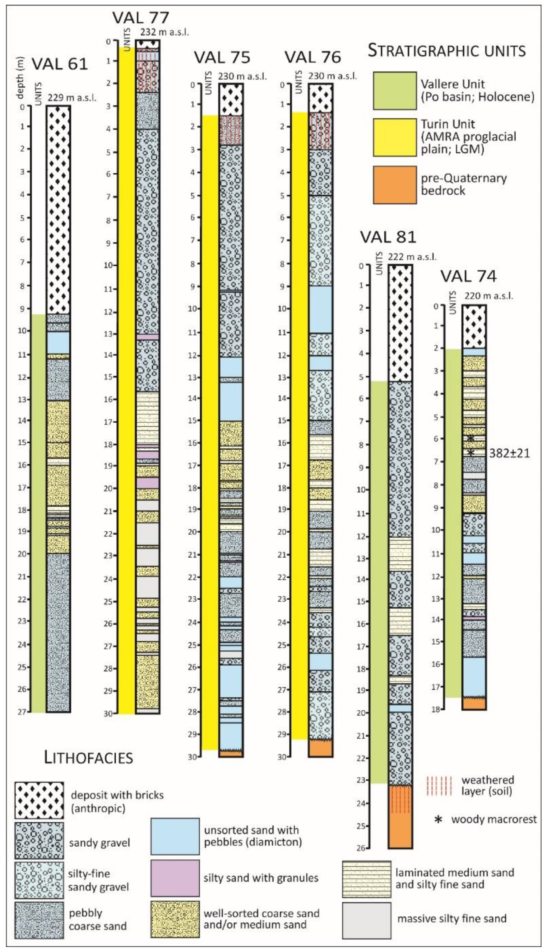
Most boreholes (Figure 5) are located on the surface of the wide RAES proglacial plain in the altitude range from 240 to 233 m (18–20 m, which is higher than the mean Po River level), consisting of the Turin Unit. Their upper sequence consists of fluvial deposits with alternating heterometric clast-supported gravel and gravelly sand, with minor lenses of medium to coarse sand. The gravel is formed of pebbles and less abundant cobbles, with average diameters ranging between 2 and 5 cm and a maximum of 8–10 cm. The prevalence of well-rounded elongated pebbles suggests long-distance fluvial transport through a river channel. Broken clasts are common due to the borehole drilling.
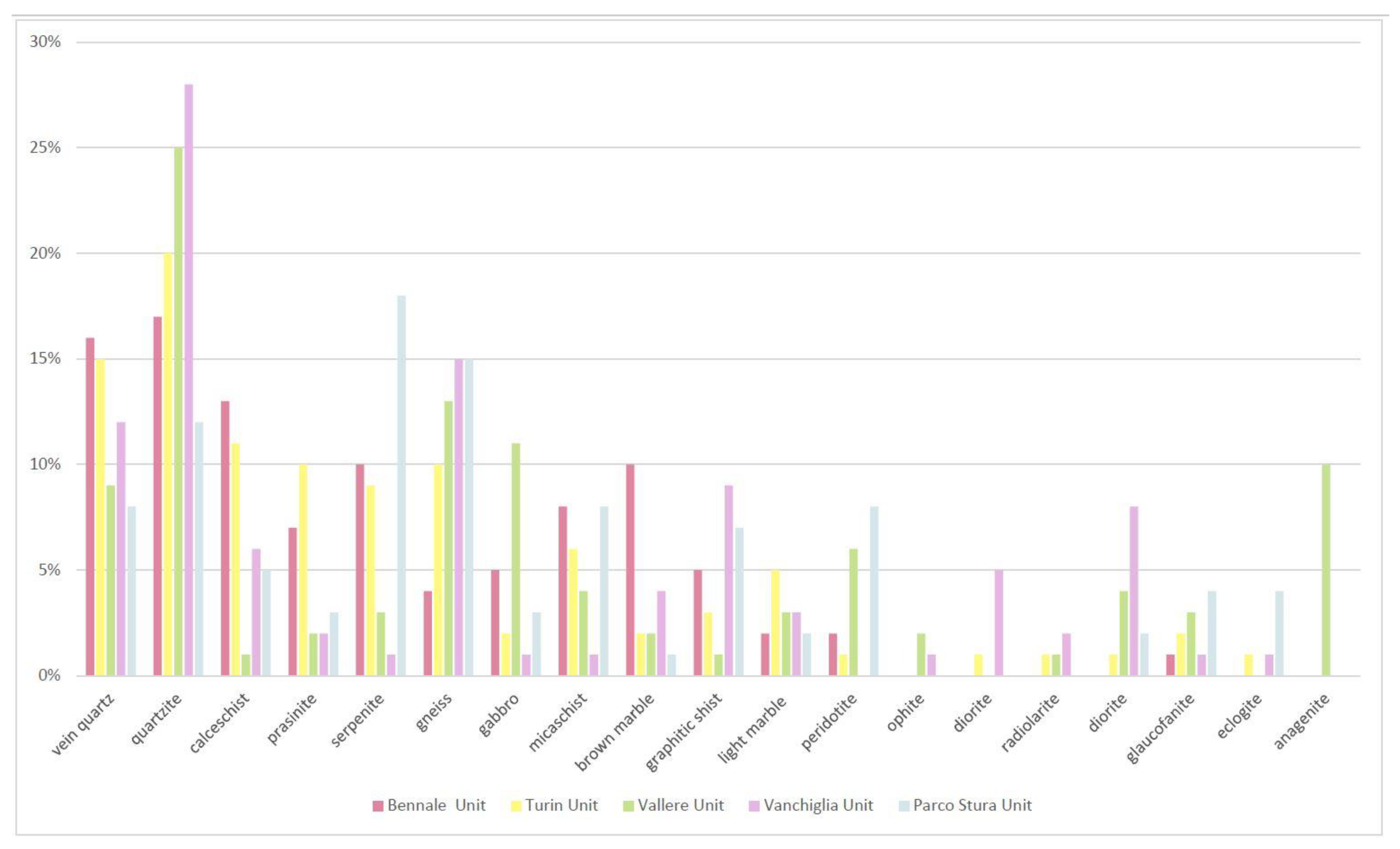
The highly variable petrographic composition of the clasts, formed by calcschist, serpentinite, prasinite and rare metagabbro (provided by undifferentiated ocean units), as well as peridotite (provided by the Ultramafic Lanzo Complex), gneiss, micaschist, marble and dolomitic marble (provided by the Dora Maira and Ambin massifs), quartzite and vein quartzite, suggests a supply from the tributary Alpine watercourses of the western sector of the Alps, mainly from the Dora Riparia catchment. Lithotypes, such as conglomeratic quartzite (anagenite), which is abundant in the southern sector of the Alps and provided by the Po southern tributaries (the Varaita, Maira, Grana and palaeo-Tanaro rivers [29]), are instead absent, confirming the Dora Riparia provenance (Figure 6).
Layers of light, yellowish-brown (2.5 Y 6/4) gravelly sand or medium-fine sand, with an overall thickness of up to about 11 m (PES 02), can also be interpreted as linked to the occurrence of low-gradient sandy rivers of the Turin Unit with a poor sediment load, which may be the emissaries of proglacial lakes. This unit, with an overall thickness of up to 35 m in the investigated area, is characterized by a light gray color (10 YR 7/2) and unweathered clasts, which clearly indicates scarce carbonate cementation, but thick lenses of conglomerate and sandstone are also common.
These sediments in the outcrops near the Turin Hill foot show trough crossbedding and clast imbrication with a b-axis dip of N160–200°/10–35°, suggesting an average flow trending north (from N340° to N20°). These features can be viewed in reference to the proglacial plain, essentially supplied by the Dora Riparia and Sangone basins, referred to as Turin Unit.
The cores show that the fluvial gravel and sand are generally characterized at the top by a sandy-clayey matrix, with a ped-and-cutan texture, a prominent brown color (7.5 YR 4/4) (Figure 7Ab) and weathered pebbles, with significant clay skins on the peds and clasts (PES 02, PES 03, PES 05, PESC 02, PES 28 and PES 29) (Figure 8A). These surficial sediments can be read as a 3 m-thick pedogenized B horizon and up to 5 m-thick B + C horizons connected to soil formed on the fan surface, which gradually fades downwards to unweathered sediments. Locally cemented gravel or sand layers are visible and particularly widespread along the borehole upper stretch, immediately below the more surficial pedogenized level. The gravel often shows iron oxide skins on the surfaces of the pebbles. The presence of the original soil suggests the good preservation of the original top of the Turin Unit, weakly sloping east, which is in agreement with the surficial data collected during the recent geological survey (e.g., at the Zini Street outcrop, Figure 6 in [11]).
Some cores also show a thin level of clayey-sandy silt (1–2 m thick) at the top of the natural sequence, immediately below the landfill cover (PES 01, PES 06, PESC 01, PES 29bis and PES 30) (Figure 7Aa). These sediments are also characterized by brown-yellowish color (10 YR 5/4) and iron oxide cementation. This layer, at the top of the fluvial sequence, can be read as overbank silty sand involved in the pedogenesis of the area, suggesting the full preservation of the proglacial sequence (Figure 8B). The presence of fine sediments at the top of the gravel was also observed in some outcrops during the geological survey (Figure 6 in [11]).
4.1.2. Boreholes Located on the Erosional Molinette T1 Terrace
A few boreholes are, alternatively, located on the Molinette T1 terrace in the eastern sector of Turin in the altitude range of 232–230 m (15–16 m higher than the mean Po River level), entrenched from 2 to 4 m on the surface of the proglacial plain (PESD 06, VAL 77, VAL 75, VAL 76 and PES 19) (Figure 7Ad). This terrace originates from weak erosion caused by the Po River in the more ancient sediments of the Turin Unit, which is responsible for the partial erosion of the surficial soil, as locally observed in a borehole (PES 19) and during the geological survey of the wide outcrop of the Aldo Moro building site (Figure 7A in [11]).
A numbers of boreholes are, alternatively, located along the slightly inclined scarp that separates the proglacial plain surface of the Molinette T1 terrace (PES 13, PES 14, PES 16, PES 17 and PES 18) (Figure 7Ac) from the sharpest scarp between the T1 and Murazzi T2 terraces (PES 07). All the cores in these sites show, at the top of the natural sequence immediately below the anthropogenic deposits, 1–4 m-thick clayey gravelly sand of a typical deep brown and mottled color (7.5 YR 5/6-8), characterized by oxide cementation and containing many weathered clasts (Figure 8C). These sediments, with a sharp basal surface, are related to colluvium formed by the reshaping of the fluvial scarp.
4.1.3. Boreholes Located on the Erosional Murazzi T2 Terrace
Only one borehole is located on the Murazzi T2 terrace in the eastern sector of Turin in the altitude range of 227–226 m (9–11 m higher on the mean Po level), entrenched from 5 to 6 m in the T2 terrace (PES 15) (Figure 7Ae). The cores, essentially, show unweathered gravel alternated with gravelly sand. Specifically, the matrix is sandy and clay-free, and the colors of sediments commonly range from light gray (2.5 Y 7/1-2) to a brown color (10 YR 6-5/3), suggesting a lack of weathering. The absence of both surficial sand or silty sand and soil suggests more significant erosional phenomena involving the Turin Unit. This terrace, then, consists of another erosional terrace which can be connected to significant erosional phenomena of the Po River, involving the more ancient sediments of the Turin Unit, which are responsible for the total removal of the surficial soil. Unweathered sandy gravel, forming the T2 terrace, were also observed during the recent geological survey (e.g., in the Car Museum outcrop; Figure 7F,G in [11]).
4.2. The Upper Sequence of the Po Depositional Vallere T3 Terrace
Some boreholes are located on the Vallere T3 terrace in the eastern sector of Turin in the altitude range of 222–214 m (4–5 m higher on the mean Po level), highly entrenched in the previous Dora Riparia terraced succession (PES 09bis, PES 10, PES 11, PES 12, VAL 61, VAL 74 and VAL 81) (Figure 7Ag). The cores in this site, essentially, show unweathered sand alternated with gravelly sand. The sandy layers are soft, fine- to medium-grained and of a grayish brown color (2.5 Y 5/2) (Figure 8D). They contain fine gravelly sand layers and thin lenses of planar-parallel laminated silt (Figure 9). The clasts formed in the gravelly layers are well-rounded and centimetric to decimetric in size, with a prevalence of discoidal pebbles, essentially formed by quartzite in the presence of anagenite pebbles. Outcrops observed during the geological survey show that the sand and gravelly sand are characterized by trough crossbedding (Figure 8E in [11]). These sediments form a depositional terrace connected to entrenching and subsequent sedimentation by the Po River, as testified by the different facies and petrographic composition compared with those of the Turin Unit (Figure 5).
4.3. The Upper Sequence of the Tributary Watercourses
4.3.1. Boreholes Located in the Vanchiglia Unit
A few boreholes (PES 20, PES 21 and PES 27) are located on the Vanchiglia Terrace along the Dora Riparia River, in the altitude range of 232–225 m (Figure 7Af). This sector, on which the Vanchiglia district was built in the XIX century, is about 3 m high, situated above the floodplain where the Dora Riparia River flows. Below the anthropogenic deposits, two boreholes (PES 21, PES 27) show heterometric gravelly sand with an overall thickness of about 21 m, containing pebbles with an average diameter of 1–3 cm and small cobbles (maximum 8 cm), referred to as the Vanchiglia Unit. Locally thin layers of sandy gravel and medium-fine sandy layers can be observed. A thick sequence of gravel (25 m) with thin layers of sand are visible in PES 20 and in many others cores published by Geoportale ARPA Piemonte, located 1 km upstream on the same terrace. These sediments have a light olive-brown/pale brown color (from 2.5 Y 5/3-4 to 10 YR 6/3) and are unweathered, containing only locally weathered clasts deriving from the reworking of more ancient fluvial sediments. This 20–30 m-thick succession has a higher degree of carbonate cementation than the other fluvial sediments due to the presence of numerous 1–2 m-thick, highly cemented layers.
4.3.2. Boreholes Located in the Parco Stura Unit
Other boreholes (PESC 03, PES 23, PES 24, PES 25, PES 26, PES 32 and PES 33) are located on the Dora Riparia alluvial plain (229–217 m), on which the main Turin Cemetery lies, sliced by the current watercourse at a depth of a few meters (Parco Stura Terrace). Below the variably thick anthropic carryover deposits, the cores show gravelly sand, containing rounded pebbles (2–10 cm), referred to as the Parco Stura Unit (Figure 7Ah). These sediments display an overall thickness of about 20 m, as recorded using the boreholes reaching down to the bedrock (except for the short boreholes PES 32 and PES 33). Layers of heterometric clast-supported gravel are locally present in the silty-sandy matrix. In one borehole (PES 23), a thin level of sandy silt with planar-parallel bedding is observed at the top of the fluvial sequence. The sediments have a light olive-brown/yellowish brown color (from 2.5 Y 5/3-4 to 10 YR 5/4), and the clasts are essentially unweathered. Cemented layers can be observed, which are particularly thick at the bottom of the sequence.
4.4. The Lower Sequence
The lower sequence (Figure 10) is different from one borehole to another, considering the various depth of the boreholes and/or the different elevations of the bedrock. Some boreholes, especially in the SSW stretch of the sewer collector, where they are only 12–19 m deep (PES 01, PES 02, PESC 01, PESC 02, PES 06 and PES 07), show, at the bottom of the Turin Unit, unweathered sandy gravel, without a significant change in the stratigraphic sequence (Figure 7Ba). Other surficial boreholes, which are 10–15 m deep, in the NNE stretch of the sewer collector (PES 30, PES 32, PES 33) are totally established in Turin Unit gravel or Parco Stura Unit sand alternated with gravelly sand. Locally, other boreholes (PES 15, VAL 77) do not reach the bedrock.
Most boreholes, especially in the intermediate stretch of the sewer collector, show, on the bottom, over-consolidated sediments that are referred to as the Pliocene bedrock (PES 09bis, PES 10, PES 12, PES 13, PESD 06, PES 16, VAL 75, VAL 74, VAL 76, VAL 81, PES 17, PES 18, PES 19, PES 20, PES 21, PES 23, PES 24, PES 25, PES 26, PES 27, PES 29bis, PES 28 and PES 29) (Figure 7Bb,Bd,Be,Bg).
These sediments essentially consist of alternating over-consolidated marly silty and sandy layers with a gray color (5 Y 5/1), locally containing oxidized plant fragments, which are connected to a deltaic body referred to as the Villafranchian succession [35,36] (Figure 10A). More locally, the bottom sediments instead consist of fine sand, which can be connected to the marine succession of the Asti Sand (PES 23, PES 29) (Figure 10B) or clay referred to as the Argille Azzurre (VAL 81). They locally contain laminated and well-sorted alternating medium sand and coarse sand, which is rich in light mica and of brownish yellow or light yellowish-brown color (10 YR 6/8–2.5 Y 6/3).
The Villafranchian reference of the bottom sequence, which is seen in most boreholes, radically modifies the attribution of the bedrock on the proglacial plain’s eastern edge, which up to now has been referred to as the Argille Azzurre (Figure 14 in [7]).
The bedrock top indicates its lower elevation in the boreholes located in the depositional Po terrace (Vallere Unit; PES 09bis and VAL 81) and in the tributary terraces (Vanchiglia and Parco Stura units; PES 26, PES 27), confirming the terracing relationship between the proglacial plain and the subsequent units (Figure 5).
A thick sandy gravel layer of few meters in depth with marly silty fragments (clay chips) can be observed near the bottom of the fluvial sequence in certain boreholes (PES 09bis, PES 10, PES 13, PES 17, PES 21, PES 24 and PES 29bis), or we can observe a basal thin layer of silty-matrix-supported gravel (VAL 76), connected to the reworking of the underlying over-consolidated bedrock (Figure 10C). Locally fragments consist of laminated, highly compact, dark olive-brown silt (2.5 Y 3/3) with plant remains.
A major result of our study relates to the identification of a palaeosol in the subsoil sediments of the Turin Plain, which has never been reported before. A 1.5–2 m-thick sandy gravel layer with a significant clay content, weathered pebbles, evident clay skins on the pebbles and a yellowish red (5 YR 4/6) to brown (7.5 YR 4/4) color can be observed in a few boreholes (PES 03, PES 05, PES 14 and PES 17) (Figure 7Bc,Bd). The reddish layer gradually fades downwards to yellowish brown, less weathered sediments (Figure 10D).
The top of this weathered layer is found at depths ranging from 8 m to 19 m (8 m in PES 03, 12 m in PES 05, 19 m in PES 14 and PES 17) and is buried by a thick, unweathered fluvial succession of the Turin Unit. The clay content, with a red color and lower gradual boundary, is due to a pedogenized horizon which, considering the depth, can be referred to as a palaeosol, which separates two different fluvial stratigraphic units (Figure 7Bc,Bd). Other cases of the overlap of two fluvial units are also possible where the palaeosol is lacking, but erosional phenomena during the more recent deposition have totally eliminated them (Figure 7Be).
The palaeosol elevation ranges from 229.5 m a.s.l. (PES 03) to 212.90 m a.s.l. (PES 17), resulting in an altitude difference of approximately 15 m, which is in agreement with the sloping towards the NE of the outwash plain (5 km between PES 03 and PES 17). Nevertheless, the presence of more than one palaeosol at different depths has to be considered (see Section 6).
A similar palaeosol, covered by a thick succession of the Turin Unit, can be observed locally by field observation, situated about 5 km upstream along the Sangone River’s incision at Fornaci (Beinasco) and referred to as a more ancient proglacial fluvial unit known as the Bennale Unit [34].
5. Anthropogenic Deposits
The different boreholes show landfill deposits at the top regardless their geomorphological location. They consist of large amounts of gravel with a prevalent matrix-supported texture and a mottled-colored, silty-sandy matrix. These deposits in the cores can be easily recognized as derived from anthropogenic carryover on account of findings of fragments of bricks and/or artefacts. The landfill cover is variably thick, ranging from 30 cm (PES 01) to 10 m (PESC 03) or more.
The landfill cover, generally, is not especially thick on the proglacial plain, resulting in a depth of less than 1 m in most SMAT cores. Less deeply buried natural surfaces extend over the peripheral sectors of Turin to the north, near the Stura-Po confluence (40 cm in PES 29bis, 1 m in PES 29 and 1.30 m in PES 30), and to the south, between the Sangone River and Lingotto factory (30 cm in PES 01, 70 cm in PES 02 and 1 m in PES 03). However, thick carryover deposits (3 m in PES 05, 3.40 m in PESC 02 and 2.80 m in PES 16) are not uncommon, being related to the local infilling of building or road yards. Indeed, the Geoportale ARPA Piemonte cores reveal dozens of the cases of this situation, both in the modern neighborhoods (e.g., the 2.5–3.5 m-thick landfill in the Lingotto factory courtyard) and in the city center (i.e., 3.5 m in Aldo Fusi Square and 5 m in Bodoni Square and in the Galileo Ferraris Course, likely connected to the filling of the defense ditches when the great ramparts of 17th century were demolished, starting in the year 1800 on the order of Napoleon). Various archaeological yards in the historic center, which are deepened with thick layers of anthropogenic and/or alluvial sediments (related to the discharge of sewers and artificial channels) of historical age (from Roman to modern), conceal the natural surface (e.g., the 3–4 m-thick cover below Carlo Alberto Square in [37]).
A significant feature is that of the original presence of short but deep tributary incisions, deepened at the edge of the outwash plain towards the Po river, which, nowadays, are no longer visible, as they are buried by thick anthropic fillings (Figure 2). Specifically, three main incisions are known because they are represented on old maps. A first depression was mapped close to the northern side of the Valentino Castle, where the botanic garden is placed. Here, a 5 m-thick landfill cover was recorded by the VAL 81 borehole. A second incision (named Molinella on an IGM map of 1911) is located south of the Molinette Hospital, as reported by some Geoportale ARPA Piemonte boreholes, with a landfill cover up to 7 m thick. The PES 12 borehole (7 m of carryover) seems to be located at the paleo-incision outlet. Finally, a third incision is located 1.5 km south (just north of PES 06 and PES 07) in the Millefonti (i.e., thousand-sources) locality on IGM maps of 1911 and 1923, in which there gushed various water springs which fed the Turin aqueduct.
The great thickness of these materials is shown by certain boreholes, such as the cores of the Molinette Hospital sector (VAL 61, PES 11, PES 12), which show an anthropic 9–11 m-thick cover formed in order to build important roads (i.e., to link the T3 terrace, on which Corso Unità d’Italia is built, with the higher T1 terrace, on which the Valentino sector is located). Another significant anthropic cover can be observed below recent large buildings (i.e., BIT), which brought with it the necessity to radically change the original morphology.
Integrating the lithostratigraphic data and numerical ages has made it possible to recognize wide stretches of a low terrace, which is buried under thick anthropogenic deposits and, consequently, not visible. The resulting high surface was initially referred to as the T2 terrace, and the underlying deposits as part of the Turin Unit, due to the scarcity of subsurface data. On the contrary, the new borehole data allow us to relate the buried surface to the T3 terrace and the corresponding deposits to the Vallere Unit (see Section 6).
6. Radiocarbon Dating
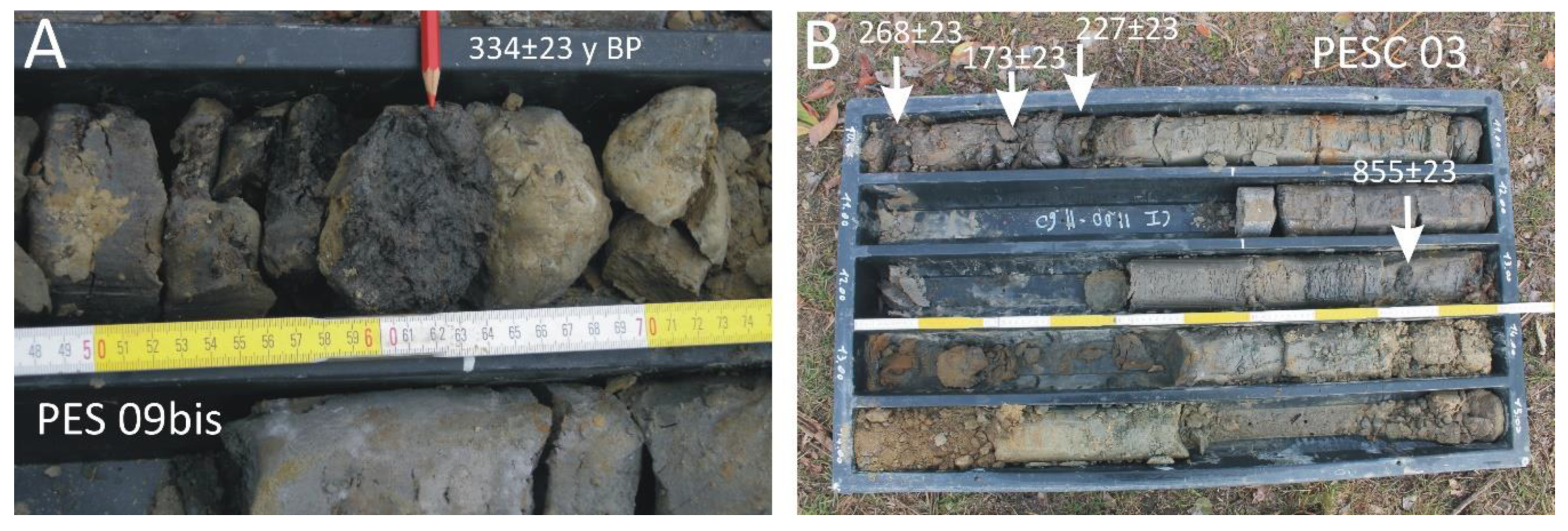
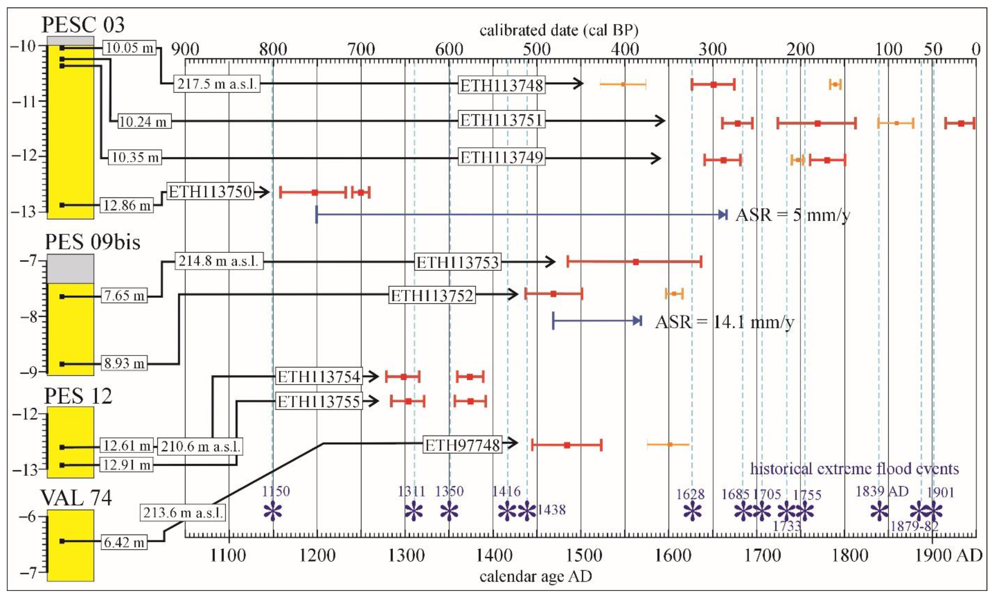
Only five cores of the 40 examined borehole cores provided organic matter that was suitable for radiocarbon dating, with a total of 10 14C ages obtained (Figure 11). Four dated samples were supplied from the PESC 03 borehole, two from PES 09bis, two from PES 12, one from VAL 74 and one from PES 17. All samples are woody macrorests of a centimeter scale, except for a small charcoal sample (in PESC 03, which provided the most recent age, i.e., 289–137 a cal BP) and a bulk sediment sample (in PES 17, which provided the only significantly older age, i.e., 37.7 cal ka BP) (Figure 11).
Most of the cores (PES 09bis, PES 12 and VAL 74) were derived from boreholes located on thick carryover deposits which cover buried surfaces, now referred to as the depositional terrace of the Po River (Vallere terrace T3). Elsewhere, the cores were derived from boreholes located on a buried surface, now referred to the low depositional plain of the Sangone River (Parco Stura Terrace; PESC 03) or on the scarp between the proglacial plain surface and the T1terrace (PES 17).
Woody macrorests were generally extracted from partially organic gyttja layers embedded in fine fluvial sediments (Table 1). The PESC 03, PES 09bis, PES 12 and VAL 74 samples are connected to bodies of fine sand and silt (i.e., overbank sediments) at the summit of a sandy-gravelly fluvial sequence referred to as the Parco Stura Unit (PESC 03) and the Vallere Unit (PES 09bis, PES 12, VAL 74), covered by very thick (7–10 m) anthropogenic carryover deposits. On the contrary, the PES 17 sample is connected to a basal fine layer below a thick gravelly fluvial sequence, also referred to as the Turin Unit, without a significant carryover cover at the top.
Specifically, the borehole PESC 03, located on thick carryover deposits covering the Parco Stura terrace at 227.5 m a.s.l., yielded peaty-sandy clay of a grayish brown color (10 YR 5/2) at a depth of 10–13 m, alternated with sandy-silty layers, which preserves millimeter-length woody fragments. Four samples of wood collected at depths of 10.5 m, 10.24 m (small carbon), 10.35 m and 12.86 m supplied radiocarbon ages of 268 ± 23 (ETH-113748), 173 ± 23 (ETH-113751), 227 ± 23 (ETH-113749) and 855 ± 23 14C a BP (ETH-113750), respectively (Figure 12). This 3 m-thick body of organic fine sediments lies on gravelly sand and is covered by 10 m-thick carryover deposits.
Samples collected from borehole PES 09bis, located on carryover deposits covering the T3 terrace at 222.50 m a.s.l., are connected to a 1.6 m-thick layer (7.4–9.0 m deep) of silty fine sand with a light gray color (2,5 Y 7/2), which is locally thinly laminated, containing rare woody fragments. Two samples of wood collected at depths of 7.65 m and 8.93 m supplied radiocarbon ages of 334 ± 23 (ETH-113753) and 412 ± 23 14C a BP (ETH-113752), respectively (Figure 12). This 3 m-thick body of fine sediments lies on gravelly sand (9–17 m deep) with a light gray color (10 YR 7/2), covering sandy gravel, and is buried below 7.4 m-thick carryover deposits at the top.
Samples collected from borehole PES 12, located on carryover deposits covering the depositional Vallere T3 terrace at 223 m a.s.l., are connected to an approximately 50 cm thick layer of sandy fine gravel at 12.45–13 m deep, embedded in the lower half of a 7.2 m-thick body of medium-fine sand (7.3–14.5 m deep). The sand is well-sorted and locally laminated, with a poor silty and gravelly fraction. Two samples of wood collected at depths of 12.61 m and 12.91 m supplied radiocarbon ages of 672 ± 23 (ETH-113754) and 654 ± 23 14C a BP (ETH-113755), respectively (Figure 12). This 7 m-thick body of fine sediments lies on gravelly sand (14.5–16.5 m deep) with a light gray color (10 YR 7/2) and sandy gravel (16.5–24 m deep), covered by 7.3 m-thick carryover deposits.
Borehole VAL 74 is located on the T3 terrace at 222 m a.s.l. in Valentino Park, very close to the Po River. A wood fragment was collected from a 6.42 m-deep fine layer of a light brownish gray color (2.5 Y 6-5/2), interbedded within a 15 m-thick body of decimeter thick layers of sand with a light olive-brown color (2.5 Y 5/3). This fluvial sequence is covered by 2 m-thick carryover deposits. The wood fragment supplied a radiocarbon age of 328 ± 21 a 14C BP, corresponding to a calibrated age of 1445–1522 AD. This dating provides a Late Holocene age for the Vallere Unit.
Most of the reported dating ages (referring to PESC 03, PES 09bis, PES 12 and VAL 74) offer historical ages, since the raw radiocarbon dates, overall, ranged from 855 ± 23 to 173 ± 23 a BP. Derived calibrated ages ranged in the period from 792–137 cal a BP, corresponding to calendar ages from 1158–1813 AD.
Obtained dated sequences are essentially in chronological order, providing ages decreasing in an upward trend (Figure 12). Only the upper samples in PESC 03 (ETH-113748) and in PES 12 (ETH113754) show the up-core inversion of ages, which may suggest episodes of short-term sediment storage and the subsequent reworking and incorrect age of the deposition. However, these ages partially overlap with the ages of the underlying samples, considering the errors, so that a chronological order can potentially be reached in any case.
The consultation of historical archives made it possible to reconstruct a series of serious flood events that affected Turin during the last 1000 years. This series is still incomplete due to a lack of data related to the 14th (second half) and 15th centuries. A few levels of the dated deposits enable a correlation with historically documented flood events (Figure 12). The lowest layers (at 210.6–210.9 m a.s.l. in PESC 12) are clearly connected to the AD 1311 flood event. However, these two layers are located slightly below the current mean level of the Po River (about 212 m a.s.l.) and, therefore, consist of riverbed sediments deposited in a previous, much wider riverbed environment. The three highest layers (at 217.2–217.5 m a.s.l. in PESC 03) can be referred as to overbank sediments formed on the top of the T3 terrace during different known flood events ranging in date from 1628 to 1755 AD. Two other dated layers, sampled in different cores (at 213.5 m and 213.6 m a.s.l. in PES 09bis and VAL 74, respectively), have very similar elevations and radiocarbon ages and could be attributed to an undocumented flood event occurring in the second half of the 14th century. The oldest historical age was supplied by a layer at 214.7 m a.s.l. in PESC 03, and it relates to an unknown event between the 12th and 13th centuries.
Only one sample provided a considerably ancient radiocarbon age (32.955 ± 465 a BP), corresponding to a calibrate age of 37.8 ka BP (ETH-113756) (Table 1). It is related to the PES 17 borehole drilled at the edge of the proglacial plain, close to Valentino Park. The sample consists of a bulk sediment collected at a low depth (18.30 m) from a 70 cm- thick clayey-silty gyttja with a very dark grayish brown color (2.5 Y 3/2). This very fine and organic layer refers to a low-energy alluvial environment and lies at the bottom of a 16 m-thick fluvial unit composed pf alternating sandy gravel, gravelly sand and sand, weathered by a 2 m-thick soil at the top with peds of a deep brown color (7.5 YR 5/8). This sequence, referred to as the Turin Unit, is buried under 2 m-thick carryover deposits. Just below the dated basal layer, another 14 m-thick fluvial succession developed (21–33.5 m deep), which preserves a 3 m-thick palaeosol at its top (described in Section 4.4) and rests on the Pliocene bedrock at a 33.5 m depth (198 m a.s.l.). Therefore, the dating of the basal layer as 37.8 cal ka BP connects it to the second half of MIS3 (57–29 ka) and provides a pre-LGM age for the lower fluvial unit and, contextually, a LGM age for the upper fluvial unit (Turin Unit; see Section 6).
7. Discussion
The latest studies on the Turin subsoil sediments report a reconstruction of the Holocene evolution related to the migration of the Po River and its tributaries in the Turin Plain [7,11]. In detail, the Turin proglacial outwash plain was constructed by the RAES watercourses during the LGM and, subsequently, was intersected by the Po River and its tributaries during the Holocene, which formed a terraced succession.
The unit’s supply by the Dora Riparia catchment, essentially, is suggested by the slope to the east of the outwash plain, its junction with the RAES and the petrographic composition of the sediments (Turin Unit), formed of serpentinite, quartzite and vein quartzite, gneiss, prasinite, micaschist, peridotite, metagabbro, marble and dolomitic marble, eclogite and calcschist (Figure 6).
The analysis of the sedimentary succession, observed by drilling of the SMAT boreholes, regards the features of both the upper sequence observed in the cores (landfill cover, surficial soil, overbank and colluvial deposits, as well as the lithofacies features of the surficial units) and the lower sequence (the presence of an older fluvial unit, signaled by palaeosol, and the definition of the real thickness of the fluvial units, made possible by the presence of the Pliocene bedrock at the bottom).
The investigation of the upper sequence allows us to substantially confirm the different units that were defined using the field survey according to the terrace morphology (elevation, lateral continuity and morphology), sedimentary facies of the associated deposits and the degree of soil development.
A surficial soil, locally observed in rare outcrops during the field survey of the Turin Unit, occurs in numerous boreholes located on the proglacial plain, which indicates the extensive preservation of its original surface (Figure 13). This soil is only lacking where it was removed by anthropic cut-and-fill processes. The local cover of sandy silt, also corresponding to pedogenized overbank sediments, confirms this reconstruction. The borehole cores also demonstrate that the upper fluvial unit (Turin Unit) is formed of unweathered sediments at a shallow depth under the surficial soil, mostly consisting of pebbly gravel alternated with gravelly sand and sand, with minor sandy-silty layers. The numerous boreholes enhance our potential both to study the areal change in the facies and composition of the clasts and to find the wood macrorests/gyttja useful for dating the sediments.
The surficial soil is instead very thin or absent in the Po erosional T1 terrace (Molinette) and totally absent in the Po erosional terrace T2 (Murazzi), in agreement with the data collected more locally by fieldwork (Figure 13). The lack of evolved soil on the erosional terraces suggests that the first erosion of the distal edge of the proglacial plain by the Po River took place very late, i.e., after the pedogenetic phase of the warmer and moister first half of the Holocene [38].
A time gap in the range 14.0–6.8 ka BP results from the radiocarbon ages of fluvial sediments south of Turin [34], suggesting that the Po River overflow phenomenon fits with a stratigraphic gap connected to the erosional phenomena which produced the T1 and T2 terraces.
The investigation of the upper sequence also shows, firstly, that the surficial sediments in the boreholes located along the scarps between the different terraces (specifically, between the proglacial plain surface and the T1 terrace and between the T1 and T2 terraces) are colluvial and rework the surficial soil.
A few of the investigated boreholes are located on the T3 terrace (Vallere) and show a prevalent sandy facies alternated with gravel layers, which appears to be unweathered. The petrographic composition of the clasts, essentially formed of quartzite with the presence of anagenite pebbles, indicates its Po River provenance. The dating of the woody macrorests, indicating an age between 672 ± 23 and 334 ± 23 cal BP (corresponding to a calibrated age of 1279–1637 AD), proves the historical age of the Vallere Unit.
Finally, certain investigated boreholes are located on the Vanchiglia Terrace and Parco Stura Terrace and show unweathered sediments characterized by different facies (gravel, gravelly sand or sand), essentially supplied by the Dora Riparia River, which are also in agreement with the logs of the other four boreholes reported on Geoportale ARPA Piemonte immediately west of the investigated area. The dating of the woody macrorests and small carbon, indicating an age between 855 ± 23 14C a BP and 173 ± 23 14C a BP (corresponding to a calibrated age of 1158–1813 AD), also proves the historical age of the Parco Stura Unit.
The lower sequence study also shows, firstly, a 1.5–3 m-thick palaeosol at a depth of 10–20 m, buried by gravel of the Turin Unit (Figure 12). This palaeosol indicates that the deposition of the Turin Unit came about on more ancient pre-LGM gravel, which has been doubtfully correlated with the Bennale Synthem [34]. The dating of the initial sediments on this palaeosol, with an age of 39,105–36,440 a cal BP, suggests an LGM identification for the Turin Unit (Figure 12).
Only the local study of the borehole cores led to a change in interpretation, compared to the previous geological map, which was significantly connected to the occurrence of a thick body of anthropogenic sediments which masked the natural morphology. This case can generally be explained by the presence of old, very localized anthropic excavations (quarries and construction sites) or natural tributary incisions in the deposits of the Turin Unit (Figure 2), which were then filled with carryover deposits and thereby completely hidden (see Section 5). The systematic identification of thick landfill covers in the upper part of the cores and the radiocarbon dating of the deposits underlying the landfills led to a radical change in the interpretation of the terraces T1 and T2, where the PESC 03, PES 09bis and PES 12 boreholes were drilled. The very recent ages of their top-layer sediments (between 1158–1813 AD) were initially a surprising result, as they were obtained from samples collected at significant depths of the cores (i.e., from 7 to 10 m). Their lithofacies features, coupled with their young ages and location at the summit of the fluvial sequences, led us to interpret these layers as overbank deposits linked to historical Po River flood events (Figure 12). They form a substantially preserved upper part of a fluvial sequence, buried under very thick carryover deposits. The elevation of the sediments below the landfill (217.5, 2015.1 and 215.7 m a.s.l., respectively) is well-matched by the elevation of the surface of the T3 terrace (220–214 m a.s.l.). Consequently, their previous attribution to the T1 (233–227 m a.s.l.) or T2 terraces (227–222 m a.s.l.) is to be rejected. These layers are now instead referred to as younger units (i.e., the Vallere Unit or the Parco Stura Unit) and are to be placed at the top of the wide sectors of the terrace T3 (or of the Sangone Parco Stura terrace) (Figure 14).
Specifically, the 7.4 m-thick anthropogenic body observed in the borehole PES 09bis indicates that the morphologically supposed T2 terrace (with a 222.5 m elevation) represents a slightly truncated and buried remnant of the Vallere T3 terrace (with a 215 m elevation), whose top layer dates back to 1437–1637 AD.
Likewise, the 7.5 m-thick landfill, observed by the drilling of the PES 12 borehole, suggests that the morphologically supposed scarp of the terrace T1 (with the a.s.l. of elevation of 223.2 m), again, needs to be reinterpreted as the buried prosecution of the T3 terrace (with the a.s.l. of elevation of 215.7 m), whose top layer dates back to 1279–1392 AD.
In similar way, the 10 m-thick anthropogenic body in the borehole PESC 03 indicates that a misleading T1 terrace (with a 227.5 m elevation) represents the buried prosecution of a lower terrace (with a 217.5 m elevation), whose top layer dates back to 1626–1666 AD, which can be linked to the historic Sangone River activity. Its elevation, which is 1.5 m lower than that of the Parco Stura Terrace (219 m a.s.l.) and shaped by the Sangone River, which extends slightly further upstream, requires a man-made erosional truncation at the expense of the overbank deposits in the PESC 03 site.
Furthermore, the 9.20 m-thick body of anthropogenic sediments observed in the borehole VAL 61 proves that there exists a surface of the Vallere T3 terrace (with a 220 m elevation), which is completely masked by carryovers created for the construction of the Balbis Bridge (229 m elevation). Another case of thick landfill cover (7 m) was registered in the PES 11 borehole, which is located on an apparent T2 terrace at 223 m a.s.l and is likely to be related to a buried T3 terrace at 216 m a.s.l.
In the cases of VAL 61, Val 81 and PES 09bis, the correspondence with the Vallere T3 terrace, which represents a Po River depositional terrace, is also suggested by the petrographic composition of the clasts, comprising some quartzite conglomerate (anagenite), which is only compatible with the Po basin and, therefore, indicates sediments of the Vallere Unit. In conclusion, the T3 terrace along the Po River has a much greater extension than that previously known, while the high erosional terraces are consequently reduced.
8. Conclusions
The stratigraphic data recorded by the SMAT boreholes confirm the reconstruction of the Turin Plain, which was first shaped by the proglacial streams (of the Dora Riparia basin) and, subsequently, affected by erosional/sedimentary phenomena related to the Po River and its tributaries. In addition, the palaeosol recognized in the present research suggests the overlap of two fluvial units connected to the RAES proglacial plain (i.e., the Bennale Unit and the Turin Unit). The dating of the bottom of the Turin Unit (37.7 cal ka BP) confirmed a pre-LGM age for the Bennale Unit and a LGM age for the Turin Unit.
The supply of these units by the Dora Riparia basin, which implies the absence of the Po in the Turin area, is also in agreement with the evidence of the Po River preserved on the Turin Hill’s southern slope. The involvement of Pleistocene fluvial landforms in the deformation indicates the recent age of this uplift, similar to other sectors of the Apennine front [39,40,41,42,43,44,45].
An overflow phenomenon changed the Po River’s trend, which was located at the northern foot of the Turin Hill. This new Po River used previous trends of the Dora Riparia River [7]. The setting of the Po River in the Turin Plain was first affected by erosional phenomena that led to the formation of erosional terraces (T1 Molinette Terrace and T2 Murazzi Terrace). The subsequent evolution instead took place due to the formation of depositional terraces (T3 Vallere Terrace and T4 Meisino Terrace), which are highly entrenched on the proglacial plain.
The radiocarbon ages of the fluvial sediments south of Turin [34] range from ages older than 44 to the age of 14.0 ka cal BP, in the case of the paleoPo sediments (LGM and Lateglacial), and from 6.8 ka cal BP to a series of historical ages of the neoPo sediments (Holocene) (Figure 4) (Table 1 in [7]). This framework allowed us to offer an approximate dating of the Po River overflow phenomenon, ranging from the Lateglacial to Holocene. The lack of radiocarbon dating in the range 14.0–6.8 ka BP is in agreement with a stratigraphic gap connected to formation of the erosional T1 and T2 terraces. Moreover, the new radiocarbon ages for the depositional T3 Vallere Terrace supplied other historical ages (1279–1616 AD) for the current Po sediments.
Author Contributions
M.G.F., F.G. and U.S. performed the data acquisition. M.G.F. and F.G. performed the data analysis and interpretation and wrote the manuscript. U.S. participated in the data analysis and interpretation, contributing to the writing of the text. M.G.F. and F.G. reviewed the manuscript and supervised the work. All authors have read and agreed to the published version of the manuscript.
Funding
Funding provided by the University of Turin, Local Research Project 2020 ‘Role of structural and stratigraphic inheritances in the evolution of a converging margin’ (entrusted to A. Festa).
Institutional Review Board Statement
Not applicable.
Informed Consent Statement
Not applicable.
Acknowledgments
We are grateful to the General Director of SMAT, Marco Acri, and to Daniel Novarino, who is responsible for the SMAT treatment plant of Castiglione Torinese, for allowing us to examine the cores of the median collector boreholes. The collaboration with Andrea Baldan provided us with useful advice for this ongoing research.
Conflicts of Interest
The authors declare no conflict of interest.
References
- Bondesan, A.; Bassan, A.; Vitturi, A. Geologia urbana di Venezia. Atti del Convegno (Mestre-Venezia, 24 novembre 2006). Geol. Dell’ambiente 2008, 3, 1–192. [Google Scholar]
- Del Monte, M.; D’Orefice, M.; Luberti, G.M.; Marini, R.; Pica, A.; Vergari, F. Geomorphological classification of urban landscapes: The case study of Rome (Italy). J. Maps 2016, 12, 178–189. [Google Scholar] [CrossRef]
- Del Monte, M. La Geomorfologia di Roma; Sapienza Università Editrice: Rome, Italy, 2018; pp. 1–191. [Google Scholar]
- Agnesi, V. La Geomorfologia di Palermo; Sapienza Università Editrice: Rome, Italy, 2021; pp. 1–172. [Google Scholar]
- Mozzi, P.; Piovan, S.; Rossato, S.; Cucato, M.; Abbà, T.; Fontana, A. Palaeohydrography and early settlements in Padua (Italy). Alp. Mediterr. Quat. 2010, 23, 409–422. [Google Scholar]
- Falkowski, T.; Ostrowski, P.; Siwicki, P.; Brach, M. Channel morphology changes and their relationship to valley bottom geology and human interventions; A case study from the Vistula Valley in Warsaw, Poland. Geomorphology 2017, 297, 100–111. [Google Scholar] [CrossRef]
- Forno, M.G.; De Luca, D.A.; Bonasera, M.; Bucci, A.; Gianotti, F.; Lasagna, M.; Lucchesi, S.; Pelizza, S.; Piana, F.; Taddia, G. Synthesis on the Turin subsoil stratigraphy and hydrogeology (NW Italy). Alp. Mediterr. Quat. 2018, 31, 147–170. [Google Scholar] [CrossRef]
- Taddia, G. Underground exploitation in urban areas by geothermal heat pump systems: The example of Turin Politecnico test site (NW Italy). Alp. Mediterr. Quat. 2018, 31, 235–244. [Google Scholar] [CrossRef]
- Bucci, A.; Barbero, D.; Lasagna, M.; Forno, M.G.; De Luca, D.A. Urban groundwater warming in Turin area (NW Italy). Rend. Online Soc. Geol. Ital. 2019, 47, 2–6. [Google Scholar] [CrossRef]
- Ivy-Ochs, S.; Lucchesi, S.; Baggio, P.; Fioraso, G.; Gianotti, F.; Monegato, G.; Graf, A.; Akcar, N.; Christl, M.; Carraro, F.; et al. New geomorphological and chronological constraints for glacial deposits in the Rivoli-Avigliana end-moraine system and the lower Susa Valley (Western Alps, NW Italy). J. Quat. Sci. 2018, 33, 550–562. [Google Scholar] [CrossRef]
- Forno, M.G.; Gianotti, F. The Turin fluvial terraces as evidence of the new setting of the Po River. J. Maps 2021, 17, 75–85. [Google Scholar] [CrossRef]
- Geoportale ARPA Piemonte. Available online: https://www.geologipiemonte.it/comunicazioni/arpa-piemonte/articolo/geoportale-arpa-piemonte-nuovo-visualizzatore-cartografico-geo3d (accessed on 20 March 2022).
- Salvador, A. International Stratigraphic Guide. In Geological Society of America, 2nd ed.; Geological Society of America: Boulder, CO, USA, 1994; pp. 1–214. [Google Scholar]
- Reimer, P.J.; Bard, E.; Bayliss, A.; Beck, J.W.; Blackwell, P.G.; Ramsey, C.B.; Buck, C.E.; Cheng, H.; Edwards, R.L.; Friedrich, M.; et al. Intcal13 and Marine13 radio-carbon age calibration curves 0–50,000 years cal BP. Radiocarbon 2013, 55, 1869–1887. [Google Scholar] [CrossRef]
- Bronk Ramsey, C. Methods for summarizing radiocarbon datasets. Radiocarbon 2021, 59, 1809–1833. [Google Scholar] [CrossRef]
- Gelati, R.; Gnaccolini, M. Evoluzione tettonico-sedimentaria della zona limite tra Alpi ed Appennino tra l’inizio dell’Oligocene ed il Miocene medio. Mem. Soc. Geol. Ital. 1982, 24, 183–191. [Google Scholar]
- Biella, G.C.; Polino, R.; De Franco, R.; Rossi, P.M.; Clari, P.A.; Corsi, A.; Gelati, R. The crustal structure of the western Po Plain: Reconstruction from the integrated geological and seismic data. Terra Nova 1997, 9, 28–31. [Google Scholar] [CrossRef]
- Piana, F.; Fioraso, G.; Irace, A.; Mosca, P.; d’Atri, A.; Barale, L.; Falletti, P.; Monegato, G.; Morelli, M.; Tallone, S.; et al. Geology of Piemonte region (NW Italy, Alps-Apennines interference zone). J. Maps 2017, 13, 395–405. [Google Scholar] [CrossRef]
- Castellarin, A. Strutturazione eo- e meso-alpina dell’Appennino settentrionale attorno al “nodo ligure”. In Studi Geologici Camerti; Speciale CROP 1-1A; Università di Camerino: Camerino, Italy, 1994; pp. 99–108. [Google Scholar]
- Festa, A.; Boano, P.; Irace, A.; Lucchesi, S.; Forno, M.G.; Dela Pierre, F.; Fioraso, G.; Piana, F. Foglio 156 “Torino Est” della Carta Geologica d’Italia alla scala 1:50,000; APAT, Agenzia per la Protezione dell’Ambiente e per i Servizi Tecnici—Dipartimento Difesa del Suolo: Rome, Italy, 2009.
- Mosca, P.; Polino, R.; Rogledi, S.; Rossi, M. New data for the kinematic interpretation of the Alps-Apennines junction (Northwestern Italy). Int. J. Earth Sci. 2010, 99, 833–849. [Google Scholar] [CrossRef]
- Bortolami, G.C.; Crema, G.C.; Malaroda, R.; Petrucci, F.; Sacchi, R.; Sturani, C.; Venzo, S. Foglio 56 ‘Torino’ della Carta Geologica d’Italia alla scala 1:1,000,000, 2nd ed.; Servizio Geologico d’Italia: Rome, Italy, 1969.
- Dela Pierre, F.; Piana, F.; Fioraso, G.; Boano, P.; Bicchi, E.; Forno, M.G.; Violanti, D.; Clari, P.A.; Polino, R. Note illustrative della Carta Geologica d’Italia alla Scala 1:50,000. Foglio 157 “Trino”; APAT, Agenzia per la Protezione dell’Ambiente e per i Servizi Tecnici—Dipartimento Difesa del Suolo, Roma: Rome, Italy, 2003; p. 147.
- Forno, M.G.; Lucchesi, S. La successione pliocenico-quaternaria su cui è edificata la Città di Torino e il suo significato per l’utilizzo del territorio. Geol. Dell’ambiente 2014, 1, 3–10. [Google Scholar]
- Arduino, E.; Barberis, E.; Carraro, F.; Forno, M.G. Estimating relative ages from iron-oxide/total iron ratios of soils in the Western Po Valley, Italy. Geoderma 1984, 33, 39–52. [Google Scholar] [CrossRef]
- Sambuelli, L.; Comina, C.; Fiorucci, A.; Dabove, P.; Pascal, I.; Colombero, C. A 5-km long waterborne CVES survey on the Po River in the town of Turin: Preliminary results. Geophysics 2017, 82, B189–B199. [Google Scholar] [CrossRef]
- Barbero, D.; Boano, P.; Colla, M.T.; Forno, M.G. Pleistocene terraced fluvial succession, Northern slope of the Torino Hill. Quat. Int. 2007, 171–172, 64–71. [Google Scholar] [CrossRef]
- Forno, M.G.; Ben, G.; Boano, P.; Bocca, P.; Boero, V.; Compagnoni, R. Lembi di depositi fluviali provenienti dai bacini alpini nordoccidentali sulla Collina di Torino presso Villa Gualino (NW Italy). Il Quat. Ital. J. Quat. Sci. 2002, 15, 175–185. [Google Scholar]
- Forno, M.G.; Lucchesi, S. The fluvial pleistocenic terraced succession of W and NW slopes of the Collina di Torino. Ital. J. Quat. Sci. 2005, 18, 123–134. [Google Scholar]
- Vezzoli, G.; Forno, M.G.; Andò, S.; Hron, K.; Cadoppi, P.; Rossello, E.; Tranchero, V. Tracing the drainage change in the Po basin from provenance of Quaternary sediments (Collina di Torino, Italy). Quat. Int. 2010, 222, 64–71. [Google Scholar] [CrossRef]
- Carraro, F.; Collo, G.; Forno, M.G.; Giardino, M.; Maraga, F.; Perotto, A.; Tropeano, D. L’evoluzione del reticolato idrografico del Piemonte centrale in relazione alla mobilità quaternaria. In Atti Conv. Rapporti Alpi-Appennino Accademia Nazionale delle Scienze, Scritti e Documenti; Polino, R., Sacchi, R., Eds.; Roma: Rome, Italy, 1995; pp. 445–461. [Google Scholar]
- Compagnoni, R.; Forno, M.G. Significato geologico di depositi fluviali ghiaiosi pleistocenici medi nella Collina di Torino. Ital. J. Quat. Sci. 1992, 5, 105–122. [Google Scholar]
- Forno, M.G.; Lucchesi, S. Relicts of the Pleistocene Po Plain on the Western and Southern slopes of the Turin Hill (NW Italy). J. Maps 2016, 12, 394–406. [Google Scholar] [CrossRef]
- Tropeano, D.; Olive, P. Vitesse de la sédimentation holocène dans la plaine occidentale du Pô (Italie). Quaternaire 1989, 26, 65–71. [Google Scholar] [CrossRef]
- Balestro, G.; Spagnolo, G.; Lucchesi, S.; Fioraso, G.; Forno, M.G.; Cadoppi, P.; Tallone, S.; Piccardo, G.B.; Polino, R. Foglio 155 “Torino Ovest” della Carta Geologica d’Italia alla Scala 1:50,000; APAT, Agenzia per la Protezione dell’Ambiente e per i Servizi Tecnici—Dipartimento Difesa del Suolo: Rome, Italy, 2009.
- Forno, M.G.; Gregorio, L.; Vatteroni, R. La successione stratigrafica del settore destro del Conoide di Lanzo e il suo significato per l’utilizzo del territorio. Convegno Nazionale AIGeo: Ambiente geomorfologico e attività dell’uomo. Risorse rischi e impatti. Torino 28-30 marzo 2007. Mem. Soc. Geogr. Ital. 2009, 87, 237–247. [Google Scholar]
- Ratto, S.; Occelli, F. Torino, piazza Carlo Alberto. Sondaggi per la linea 2 della Metropolitana. Quad. Di Archeol. Del Piemonte 2021, 5, 262–268. [Google Scholar]
- Ortu, E.; Peyron, O.; Bordon, A.; de Beaulieuc, J.L.; Siniscalco, C.; Caramiello, R. Lateglacial and Holocene climate oscillations in the South-western Alps: An attempt at quantitative reconstruction. Quat. Int. 2008, 190, 71–88. [Google Scholar] [CrossRef]
- Benedetti, L.; Tapponnier, P.; Gaudemer, Y.; Manighetti, I. Geomorphic evidence for an emergent active thrust along the edge of the Po Plain: The Broni-Stradella fault. J. Geophys. Res. 2003, 108, JB001546. [Google Scholar] [CrossRef]
- Boano, P.; Forno, M.G.; Lucchesi, S. Pleistocene deformation of the Collina di Torino inferred from the modelling of their fluvial succession. Alp. Mediterr. Quat. 2004, 17, 145–150. [Google Scholar]
- Bruno, P.P.; Pazzaglia, F.J.; Picotti, V. Evidence for active folding and faulting at the northern Apennines mountain front near Bologna, Italy, from high resolution seismic reflection profiling. Geophys. Res. Lett. 2011, 38, L16302. [Google Scholar] [CrossRef]
- Burrato, P.; Ciucci, F.; Valensise, G. An inventory of river anomalies in the Po Plain, northern Italy: Evidence for active blind thrust faulting. Ann. Geophys. 2003, 46, 865–882. [Google Scholar] [CrossRef]
- Gunderson, K.L.; Pazzaglia, F.L.; Picotti, V.; Anastasio, D.A.; Kodama, K.P.; Rittenour, T.; Frankel, K.F.; Ponza, A.; Berti, C.; Negri, A.; et al. Unraveling tectonic and climatic controls on synorogenic growth strata (Northern Apennines, Italy). Geol. Soc. Am. Bull. 2014, 126, 532–552. [Google Scholar] [CrossRef]
- Picotti, V.; Pazzaglia, F.J. A new active tectonic model for the construction of the Northern Apennines mountain front near Bologna (Italy). J. Geophys. Res. Atmos. 2008, 113, B08412. [Google Scholar] [CrossRef]
- Ponza, A.; Pazzaglia, F.J.; Picotti, V. Thrust-fold activity at the mountain front of the Northern Apennines (Italy) from quantitative landscape analysis. Geomorphology 2010, 123, 211–231. [Google Scholar] [CrossRef]
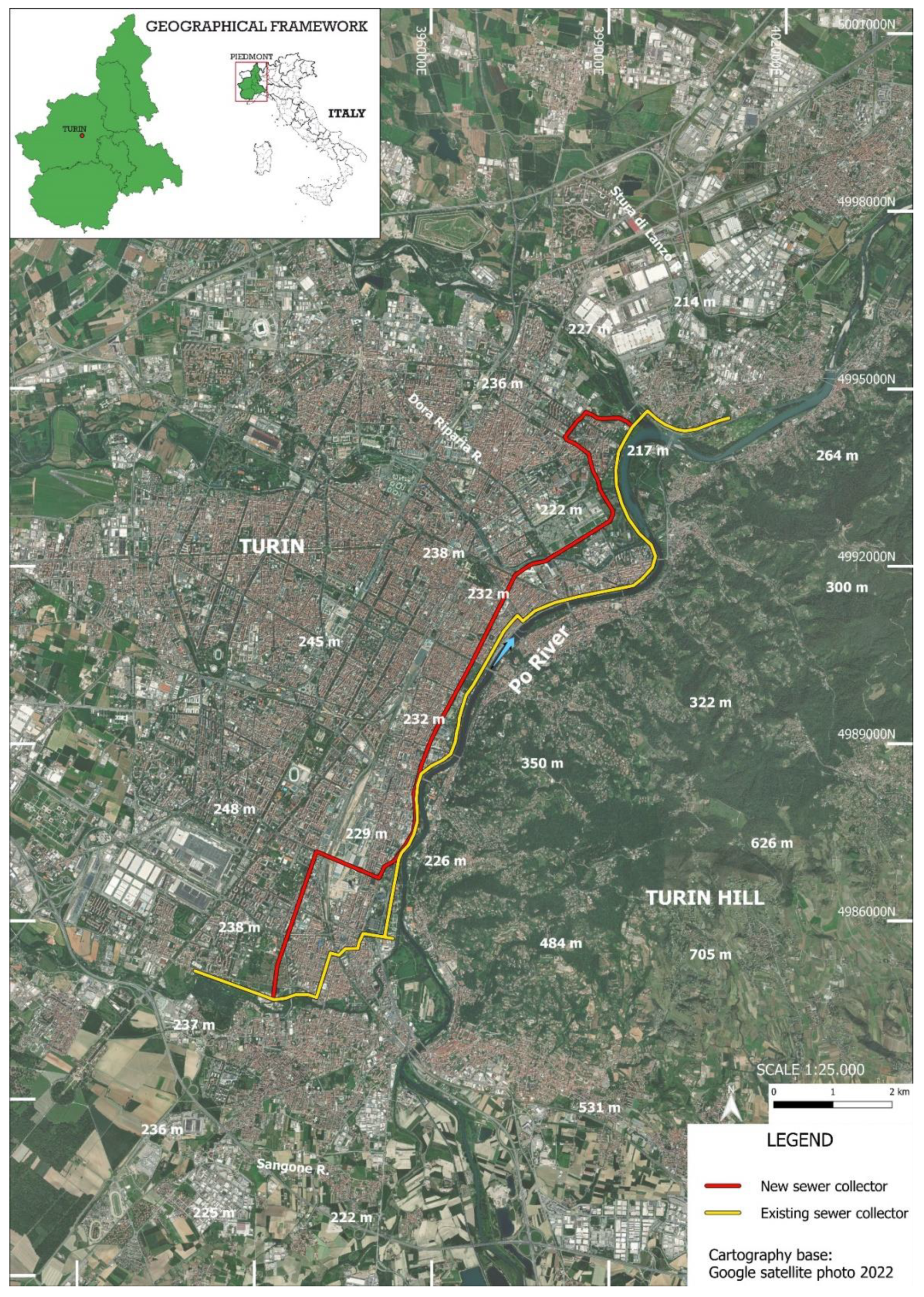
Figure 1.
Location of the new sewer collector near the Po bed in the eastern sector of Turin.

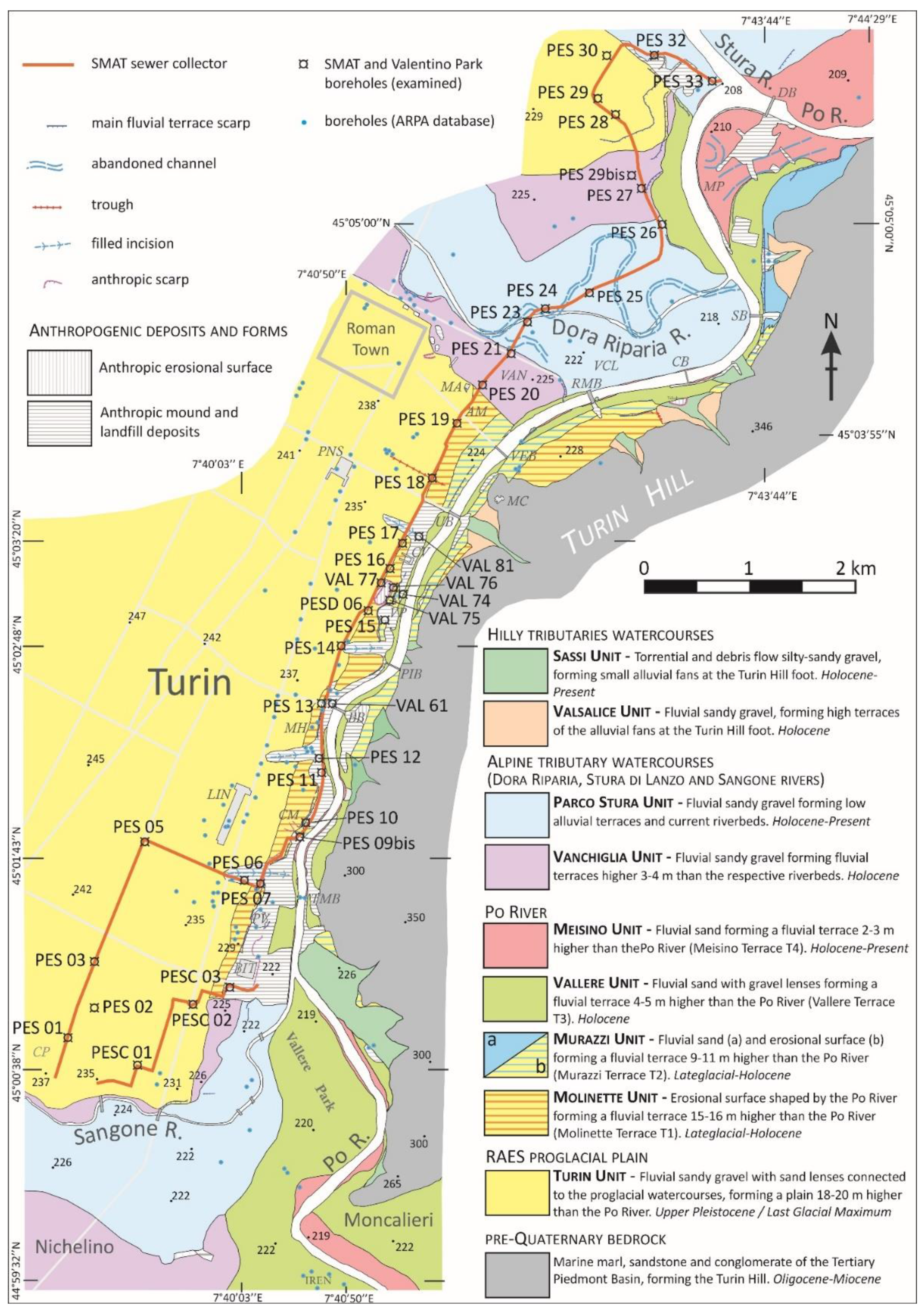
Figure 2.
Location of the investigated boreholes in Turin’s eastern sector on the proglacial plain and along the erosional and depositional terraces shaped by the Po River. Black abbreviations indicate the examined SMAT (PES, PESC) and Valentino (VAL) boreholes, while blue points refer to the previous ARPA logs. Buildings: Vanchiglia District (VAN), Vanchiglietta District (VCL), Aldo Moro Center (AM), Mole Antonelliana (MA), Porta Nuova Station (PNS), Monte dei Cappuccini (MC), Castello del Valentino (CV), Molinette Hospital (MH), Car Museum (CM), Lingotto Factory (LIN), Palazzo a Vela (PV), Palazzo del Lavoro (BIT), Valentino Park (VP), Colonnetti Park (CP), Meisino Park (MP). Bridges: Dam B. (DB), Sassi B. (SB), Coppi footbridge (CB), Regina Margherita B. (RMB), Vittorio Emanuele I B. (VEB), Umberto I B. (UB), Pricipessa Isabella B. (PIB), Balbis B. (BB), Turin Marathon footbridge (TMB) (modified from [11]).

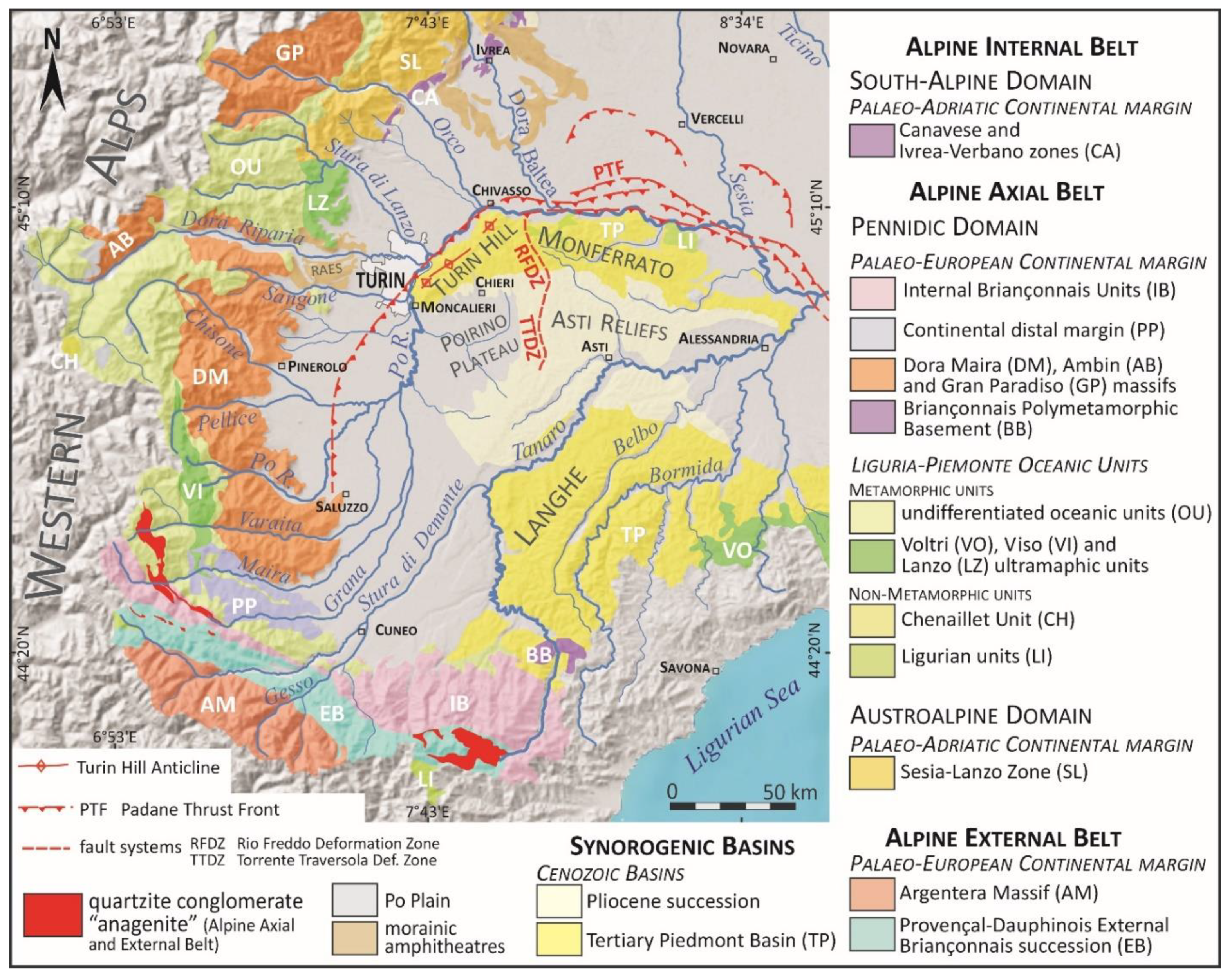
Figure 3.
Geological setting of the Western Alps and Tertiary Piedmont Basin on a DTM (gray). The supply area of anagenite in the Po and Tanaro basins is underlined, as it is a marker of lithology that characterizes the Po deposits and allows us to distinguish them from the Alpine tributary deposits in the Turin area.

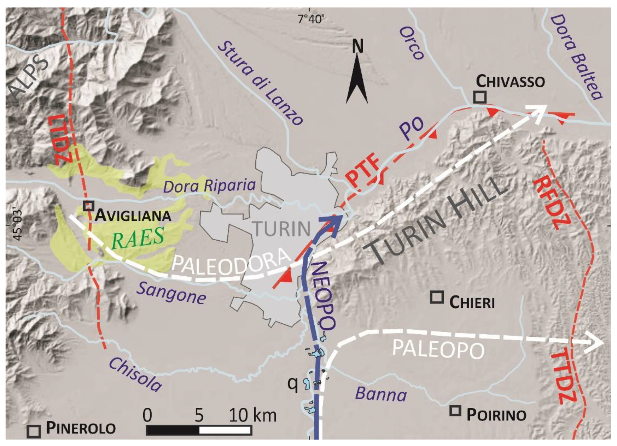
Figure 4.
Hydrographic pattern evolution of the Po Plain/Turin Hill area. The Po River flowed down the southern side of Turin Hill (paleoPo) during the Late Pleistocene. The current trend of the Po River (neoPo) is due to a Lateglacial overflow event. Previous radiocarbon dating of the fluvial sequence in the Po Plain south of Turin was based on sediments from the Moncalieri-La Loggia quarries (q) (references in [7]). RAES: Rivoli-Avigliana end-moraine system; PTF: Padane Thrust Front; TTDZ: T. Traversola Deformation Zone; RFDZ: Rio Freddo Deformation Zone (modified from [11]).

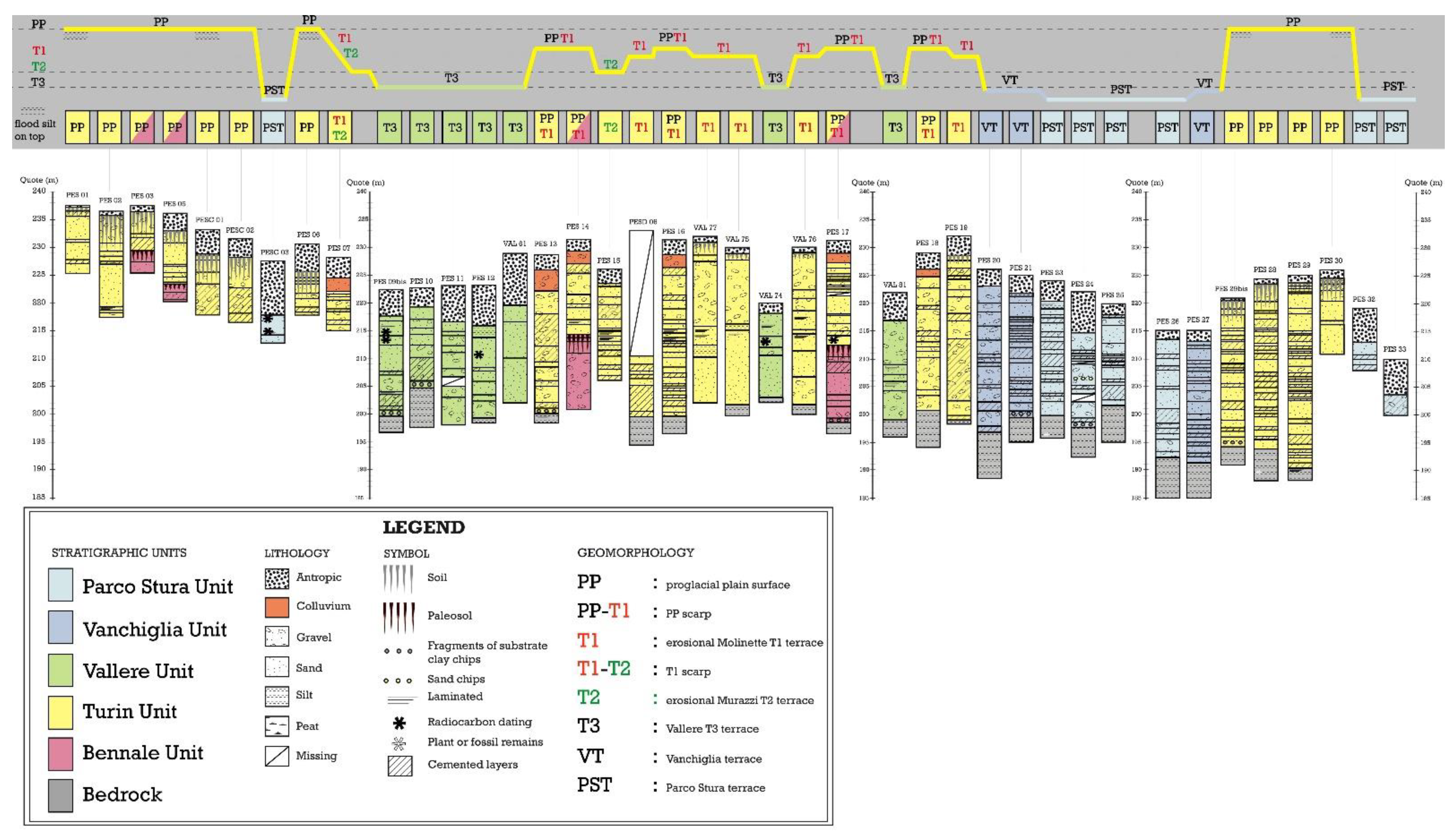
Figure 5.
Logs of the investigated boreholes characterized by various upper sequences consisting of the different mapped units (Turin Unit, T1, T2, Vallere Unit and tributary units). A simplified geological scheme with the locations of different boreholes is depicted at the top of figure.
Figure 5.
Logs of the investigated boreholes characterized by various upper sequences consisting of the different mapped units (Turin Unit, T1, T2, Vallere Unit and tributary units). A simplified geological scheme with the locations of different boreholes is depicted at the top of figure.

Figure 6.
Petrographic composition of the gravel in the various fluvial units.

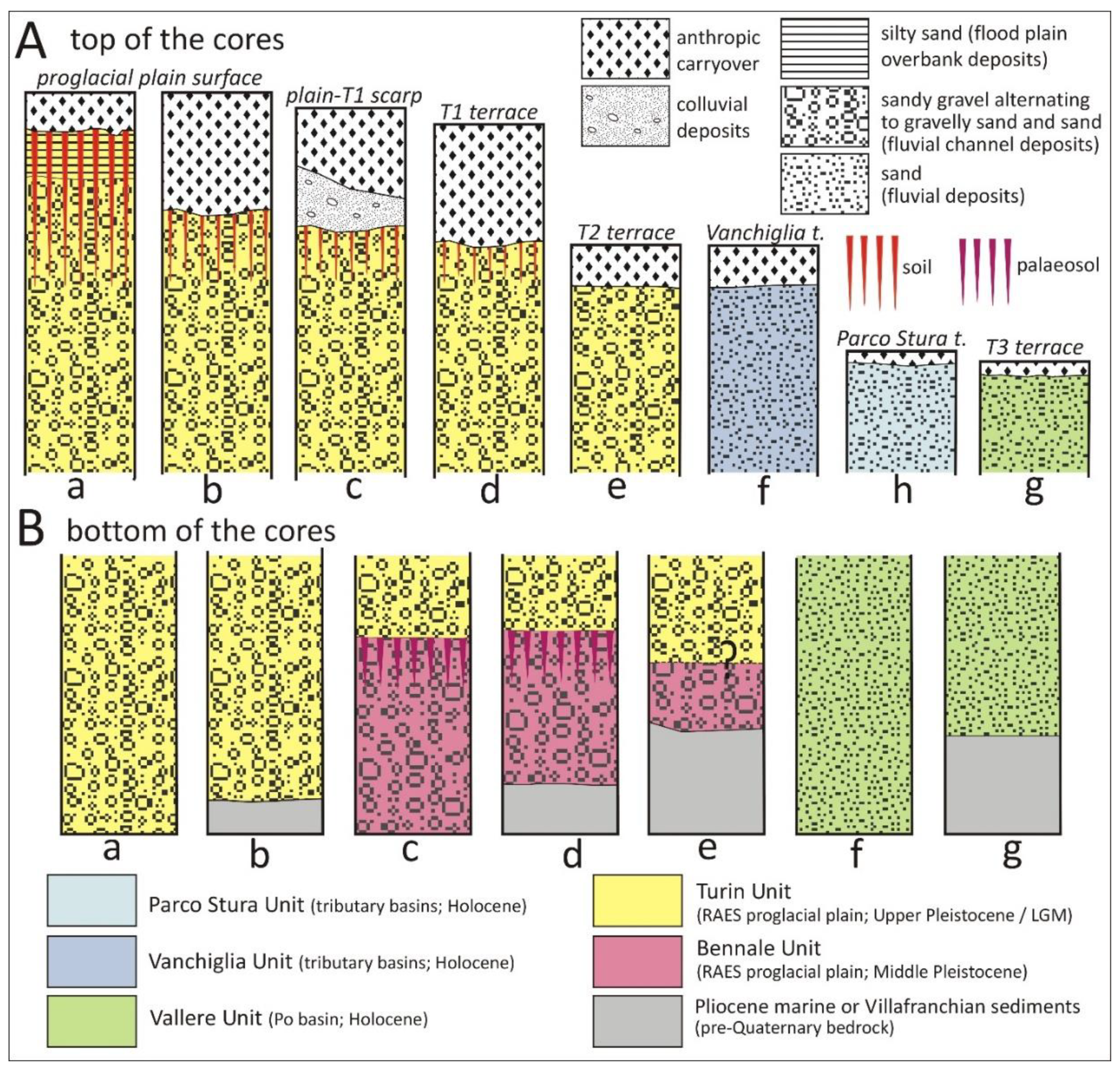
Figure 7.
Different preservation features of the upper sequence (A) and the bottom sequence (B) in the investigated boreholes.
Figure 7.
Different preservation features of the upper sequence (A) and the bottom sequence (B) in the investigated boreholes.

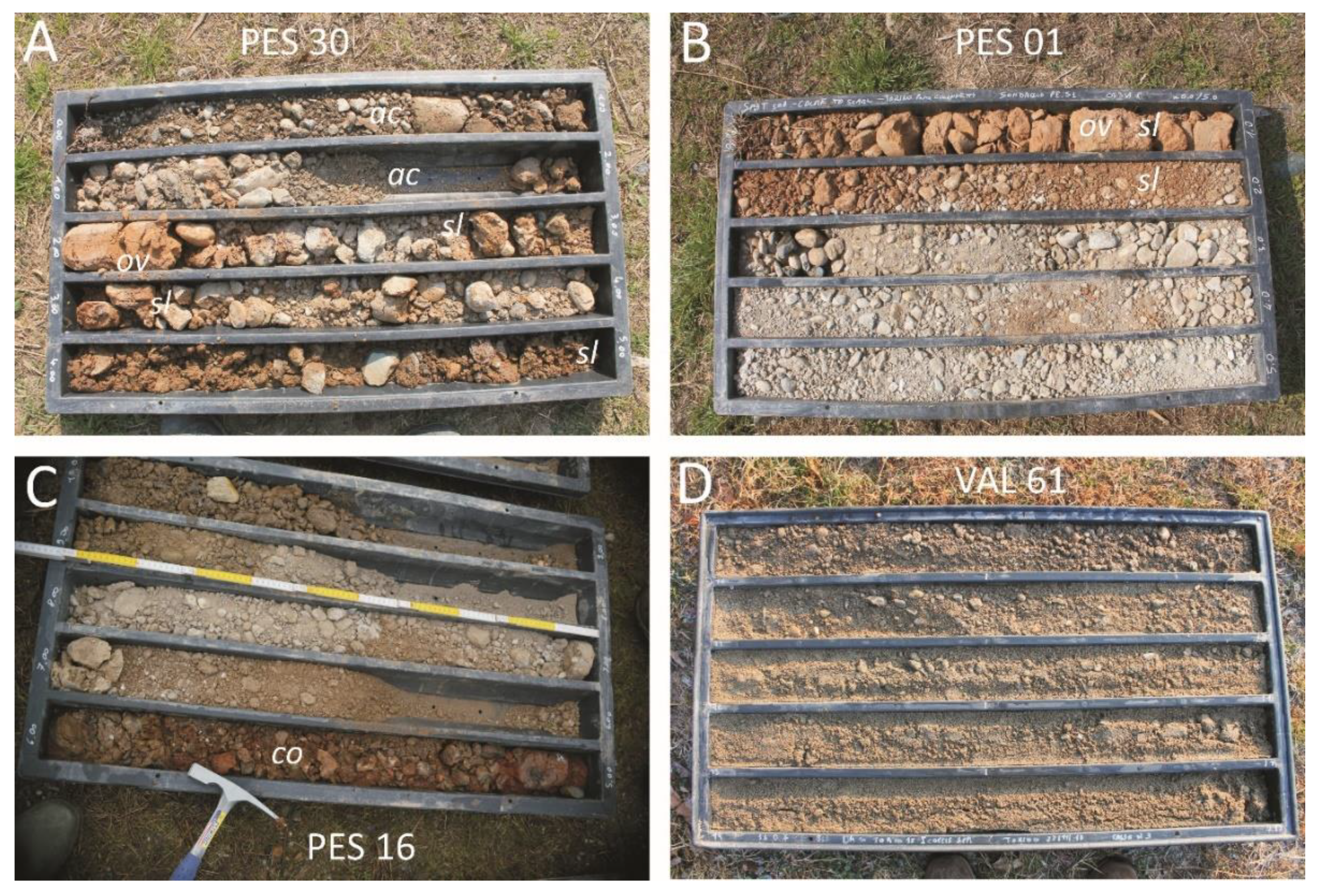
Figure 8.
Different preservation features of the upper sequence. (A) Surficial soil and (B) overbank silty sand preserved on the top of the Turin Unit. (C) Colluvium preserved along the scarp between the proglacial plain surface and the T1 terrace. (D) Essentially sandy sediments of the Vallere Unit. Note: sl: soil; ov: overbank deposits; co: colluvial deposits; ac: anthropic cover.

Figure 9.
Logs of the investigated Valentino boreholes, characterized by different upper sequences comprising the Turin Unit (VAL 77, VAL 75, VAL 76) and Vallere Unit (VAL 61, VAL 81, VAL 74).
Figure 9.
Logs of the investigated Valentino boreholes, characterized by different upper sequences comprising the Turin Unit (VAL 77, VAL 75, VAL 76) and Vallere Unit (VAL 61, VAL 81, VAL 74).

Figure 10.
Different preservation features of the lower sequence. (A) Alternating clayey silt and sand, referred to as the transitional Villafranchian succession. (B) Silty clay referred to as the Pliocene marine succession (Argille Azzurre). (C) A basal thin layer of silty-matrix-supported gravel (white asterisk), derived from the reworking of the clayey silty bedrock. (D) Red palaeosol buried under the fluvial gravel of the Turin Unit, separating two fluvial bodies (Turin Unit and Bennale Unit). Position and age of the gyttja layer, which was sampled for radiocarbon dating, is shown.

Figure 11.
Locations of the gyttja samples for radiocarbon dating. (A) Detail of the upper sample in the PES 09bis borehole. (B) All four samples collected from the PESC 03 borehole. Uncalibrated radiocarbon ages are provided. See Table 1 for the lithological data and depths.
Figure 11.
Locations of the gyttja samples for radiocarbon dating. (A) Detail of the upper sample in the PES 09bis borehole. (B) All four samples collected from the PESC 03 borehole. Uncalibrated radiocarbon ages are provided. See Table 1 for the lithological data and depths.

Figure 12.
Radiocarbon dating of the surficial fluvial bodies. Certain dated alluvial layers may, hypothetically, be related to major flood events reported in historical documents. ASR: average sedimentation rate.
Figure 12.
Radiocarbon dating of the surficial fluvial bodies. Certain dated alluvial layers may, hypothetically, be related to major flood events reported in historical documents. ASR: average sedimentation rate.

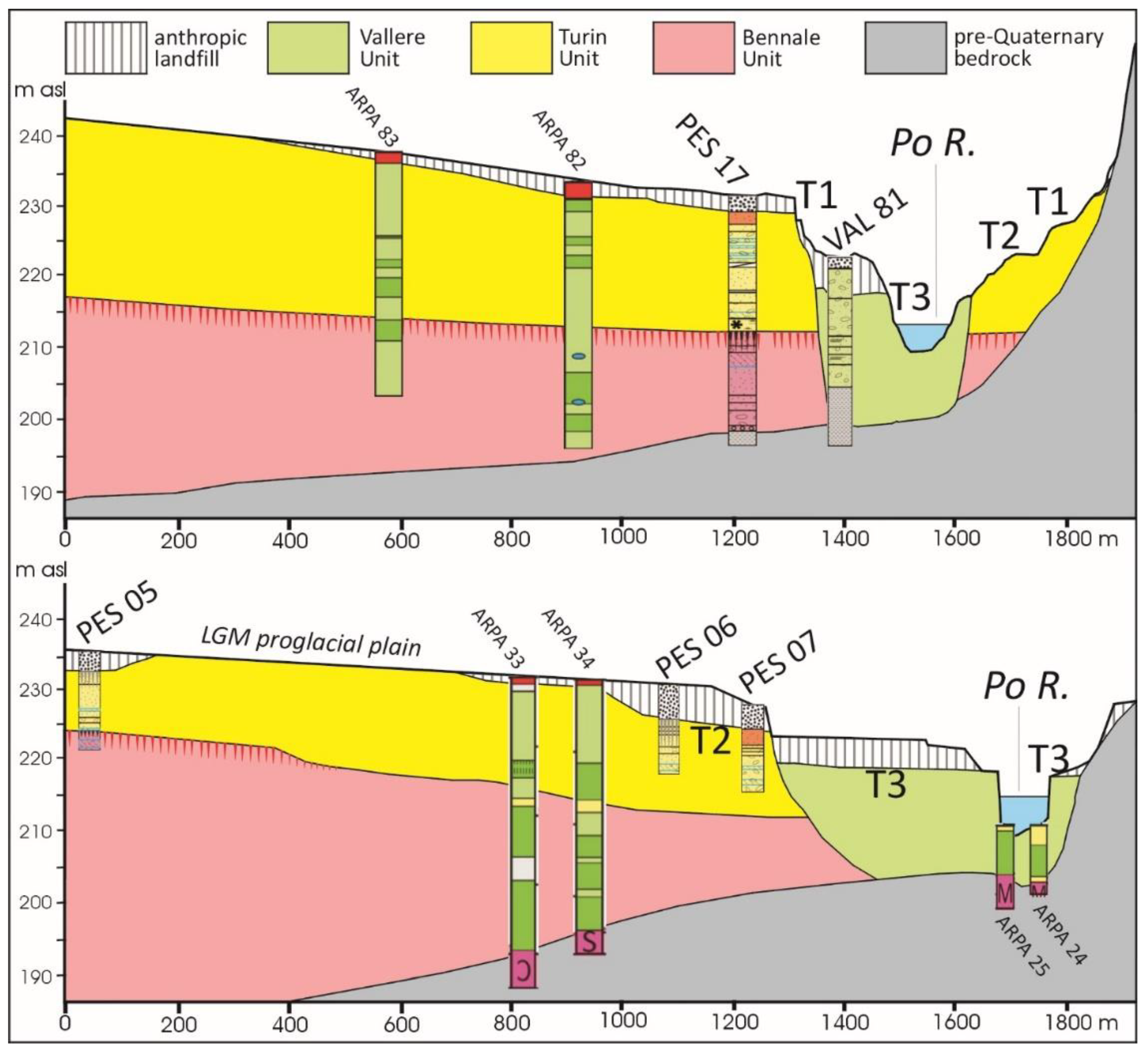
Figure 13.
Schematic W–E cross-sections along the Turin Plain formed by the LGM glaciofluvial sediments of the Dora Riparia basin (Turin Unit). The boreholes indicate the depth of the bedrock and the occurrence of a palaeosol at the top of more ancient glaciofluvial sediments (Bennale Unit). The T3 depositional terrace of the Po River, covered by anthropic sediments, is entrenched in the previous units.

Figure 14.
The thick anthropic sediments reported from PES 09bis indicate a buried Vallere Terrace, also suggested by clasts comprised of quartzite conglomerate (anagenite).
Figure 14.
The thick anthropic sediments reported from PES 09bis indicate a buried Vallere Terrace, also suggested by clasts comprised of quartzite conglomerate (anagenite).


Table 1.
Radiocarbon dating, with the boreholes, depths, facies and types of the rest of the different dated samples. The most likely ages are in bold. The dating of the sample ETH-97748 is taken from [11].
Table 1.
Radiocarbon dating, with the boreholes, depths, facies and types of the rest of the different dated samples. The most likely ages are in bold. The dating of the sample ETH-97748 is taken from [11].
| Lab. Code | Borehole | Depth (m) | Lithofacies | Material Dated | Radiocarbon Age BP | 2σ cal. Range (cal Years BP) (95.4% Probability) | Median Age BP or Calendar Age Range |
|---|---|---|---|---|---|---|---|
| ETH-113748 | PESC 03 | 10.03–10.07 | gyttja | wood macrorest | 268 ± 23 | 428–376 324–284 167–155 | 1626–1666 AD 1522–1574 AD 1783–1795 AD |
| ETH-113751 | 10.24 | gyttja | small carbon | 173 ± 23 | 289–255 226–137 | 1661–1813 AD | |
| ETH-113749 | 10.35–10.37 | gyttja | wood macrorest | 227 ± 23 | 310–269 189–150 | 1640–1681 AD 1761–1800 AD | |
| ETH-113750 | 12.86–12.87 | fine sand and gyttja | wood macrorest | 855 ± 23 | 792–717 710–691 | 1158–1233 AD 1240–1259 AD | |
| ETH-113753 | PES 09bis | 7.60–7.70 | silty fine sand | wood macrorest | 334 ± 23 | 466–313 | 1484–1637 AD |
| ETH-113752 | 8.92–8.94 | silty fine sand | wood macrorest | 412 ± 23 | 513–449 352–334 | 1437–1501 AD 1598–1616 AD | |
| ETH-113754 | PES 12 | 12.61–12.62 | sandy fine gravel | wood macrorest | 672 ± 23 | 671–634 590–562 | 1279–1316 AD 1360–1388 AD |
| ETH-113755 | 12.90–12.93 | sandy fine gravel | wood macrorest | 654 ± 23 | 666–628 594–558 | 1284–1322 AD 1356–1392 AD | |
| ETH-113756 | PES 17 | 18.30–18.35 | slightly organic gyttja | bulk sediment | 32,955 ± 465 | 39,105–36,440 | 37,770 cal BP |
| ETH-97748 | VAL 74 | 6.42 | clayey silty sand | wood macrorest | 382 ± 21 | 505–428 (72.2%) 375–327 (23.2%) | 1445–1522 AD 1575–1623 AD |
Publisher’s Note: MDPI stays neutral with regard to jurisdictional claims in published maps and institutional affiliations. |
© 2022 by the authors. Licensee MDPI, Basel, Switzerland. This article is an open access article distributed under the terms and conditions of the Creative Commons Attribution (CC BY) license (https://creativecommons.org/licenses/by/4.0/).
Share and Cite
MDPI and ACS Style
Forno, M.G.; Gianotti, F.; Storti, U. Geomorphology of the Po Fluvial Terraces in Turin Deduced by New Subsoil Data (NW Italy). Water 2022, 14, 2872. https://doi.org/10.3390/w14182872
AMA Style
Forno MG, Gianotti F, Storti U. Geomorphology of the Po Fluvial Terraces in Turin Deduced by New Subsoil Data (NW Italy). Water. 2022; 14(18):2872. https://doi.org/10.3390/w14182872
Chicago/Turabian StyleForno, Maria Gabriella, Franco Gianotti, and Umberto Storti. 2022. "Geomorphology of the Po Fluvial Terraces in Turin Deduced by New Subsoil Data (NW Italy)" Water 14, no. 18: 2872. https://doi.org/10.3390/w14182872
Note that from the first issue of 2016, this journal uses article numbers instead of page numbers. See further details here.