Article

Land Reclamation in a Coastal Metropolis of Saudi Arabia: Environmental Sustainability Implications

by
Ali M. AlQahtany
1,
Umar Lawal Dano
1,*,
Eltahir Mohamed Elhadi Abdalla
2,
Wisam E. M. Mohammed
3,
Ismaila Rimi Abubakar
4,
Wadee Ahmed Ghanem Al-Gehlani
5,
Naji Akbar
6 and
Maher S. Alshammari
1
1
Department of Urban & Regional Planning, College of Architecture and Planning, Imam Abdulrahman Bin Faisal University, Dammam 31451, Saudi Arabia
2
Department of Building Engineering, College of Architecture and Planning, Imam Abdulrahman Bin Faisal University, Dammam 31451, Saudi Arabia
3
Department of Landscape Architecture, College of Architecture and Planning, Imam Abdulrahman Bin Faisal University, Dammam 31451, Saudi Arabia
4
College of Architecture and Planning, Imam Abdulrahman Bin Faisal University (formerly, University of Dammam), Dammam 31441, Saudi Arabia
5
Department of Architecture, College of Architecture and Planning, Imam Abdulrahman Bin Faisal University, Dammam 31451, Saudi Arabia
6
Department of Interior Architecture, College of Architecture and Planning, Imam Abdulrahman Bin Faisal University, Dammam 31451, Saudi Arabia
*
Author to whom correspondence should be addressed.
Water 2022, 14(16), 2546; https://doi.org/10.3390/w14162546
Submission received: 14 June 2022 / Revised: 13 August 2022 / Accepted: 17 August 2022 / Published: 18 August 2022
(This article belongs to the Special Issue The Impact of Climate Change and Human Interventions on Coastal Zones)

Abstract

:
Coastal reclamation for residential, tourism, and commercial developments in the Arabian Peninsula and other global regions has dramatically increased in recent decades. This phenomenon is undoubtedly innovative and novel; however, it disrupts the natural balance of marine environments and degrades coastal and marine resources. Moreover, the long-term sustainability of such developments might be undermined by rising water levels, earthquakes, and the behavior of filling material and others. This paper analyzed the extent of land reclamation in the Dammam Metropolitan Area (DMA) along the eastern coast of Saudi Arabia within the last two decades and its environmental sustainability impacts. The study used satellite images to compare the coastal boundary of the study area from 2000 to 2020. The study analyzed five major reclamation projects and found that a total of 6081 hectares of land has been reclaimed from the Arabian Gulf, thereby altering the coastal profile of DMA significantly. The environmental sustainability implication of these projects includes the degradation and loss of ecosystem services and marine habitat, urban sprawl, and flood risk. Therefore, environmental regulations, such as the strict prohibition of coastal reclamation, and ecosystem-based urban planning, are needed for sustainable coastal land development.

1. Introduction

Rapid population growth, socioeconomic activities, and increased interest in coastal urbanization substantially contribute to coastal land development. Coastal zones along continental margins are zones of significant natural productivity and soaring accessibility. Therefore, coastal areas have become the heart of human activities, including residential, commercial, and recreational developments [1]. Over one-third of the global population lives in coastal zones constituting only 4% of the Earth’s area [2]. Nearly 52% of megacities housing more than 10 million around the world are situated in coastal areas [3]. Coastal developments usually reclaim shallow and tidal sea areas via land reclamation. Land reclamation occurs in several coastal settlements to ease high population density, create new urban developments, boost food production, and create jobs and investment opportunities [2,3,4,5]. However, land reclamation comes with its attendant predicaments. The conversion of coastal wetlands to build areas alters and damages the natural characteristics of the coastal ecosystem upon which living organisms and humanity depend [5,6,7,8,9,10].
Zones of coastal reclamations are vulnerable to flood catastrophes, mainly due to low lying elevation, paved surfaces, high density development, and rapid urbanization. Estimates indicate that by the end of the 21st century, the global mean sea level will continuously rise by nearly 1 m [11], which will likely provoke severe storm tides and trigger flood risks [12,13,14]. Similarly, coastal reclamation projects are more susceptible to cyclones [15]. Therefore, as these developments are likely to continue in the global coastal cities [16], there is a strong likelihood of an increase in exposure and susceptibility to coastal flooding [17]. As such, it is vital to understand the extent of land reclamation to manage its environmental sustainability impacts effectively.
In Saudi Arabia, the two coastal cities of Dammam and Jeddah are experiencing large scale coastal developments through land reclamation. However, the local marine environment houses diverse ecosystems, including coral reefs, mangrove stands, and seagrass beds [5]. In addition, the Arabian/Persian Gulf and the Red Sea regions have been under significant and continuing stress due to demographic development sprouting in countries around them, leading to major changes in the coastal and marine habitats [6,7]. For example, over 40% of the Arabia/Persian Gulf areas have been reclaimed for urban development projects by seven member states of the Arabian League, including Saudi Arabia, mainly for residential, leisure, tourism and hospitality, and commercial activities [8]. However, this practice is also associated with severe environmental impacts that can destroy biodiversity, natural coastline, wetlands, extinction of fauna and flora, pollution, and geological disasters [9,10].
Coastal reclamation in Saudi Arabia is increasingly gaining traction as an urban expansion policy with little concern of its implications on the environment. The practice here is not because of land shortage. The country is the largest in the Middle East, covering 80% of the Arabian Peninsula with a total land area of 21,150,000 km2 and a very low population density of 17 persons/km2 [18]. The literature from different parts of the globe [8,9,10,17] indicates that land reclamation projects can pose myriad adverse consequences on the sustainability of the local ecosystem. Therefore, the present study analyzes the extent of land reclamation in Dammam Metropolitan Area (DMA), a coastal metropolis of Saudi Arabia, and its environmental sustainability implications. The study’s objectives are to (a) assess and map land use and land cover (LULC) changes in DMA to determine the extent of coastal land reclamation, and (b) analyze the environmental sustainability implications of the practice in the study area.
A literature review indicates a dearth of studies on the environmental impacts of coastal land reclamation. Studies on coastal areas [19,20,21,22,23,24] focus mainly on the causes and impacts of coastal floods. In Saudi Arabia, one study in Tarut Bay in the Eastern Province employed LANDSAT and SPOT satellite images to evaluate the deterioration of mangrove forests resulting from coastal reclamation projects and related human activities [25]. No prior study has assessed LULC changes resulting from coastal reclamation and its negative environmental impacts in DMA. Therefore, the present study fills this research gap and builds on the existing literature. The study is important because DMA is Saudi Arabia’s third-largest metropolis, a coastal city with fragile marine ecosystem, which has been experiencing large-scale and long-term coastal land reclamations projects that have been associated with exacerbating floods [19,20,21,22].

2. Literature Review

Since the earliest times, economic activities have concentrated along the global coastal regions [1]. Coastal areas have been the gates for international trade and sources of marine resource explorations, which attracted populations looking for better job opportunities and prosperity, resulting in massive urbanization and industrialization along the coastal settlements. Thus, to cater for increasing demand for land has brought about the concept of coastal land reclamation. Coastal land reclamation is the process of converting sea area to land. Many centuries ago, several coastal regions in both developed nations, such as Japan [26], Netherlands [27], and the USA [28], and developing nations such as China [29,30] had executed several coastal reclamation projects for many purposes including urban development, agricultural, and industrial projects. For example, about 50% of the Chinese population resides in coastal cities [31].
The literature shows that coastal reclamation can be due to a shortage of land for expanding coastal settlements or for the desire to extend coastal frontages. For example, in Germany, Loures and Crawford [32] studied how public involvement in reclamation project in Emscher Park in the Ruhr helped achieve sustainable development in reclaimed coastal areas. Moreover, some studies [33,34,35,36] have utilized remote sensing data to assess the extent of land use/land cover (LULC) changes resulting from coastal reclamation projects. They found a dramatic increase in the reclaimed areas over the last four decades. Similarly, using LANDSAT imageries, Meng et al. [37] assessed the effects of urbanization, economic development, and population growth on coastal land reclamation in China. They found that huge economic returns were the key driver of coastal reclamation in the area. Another study in China by Tian et al. [30] using LANDSAT data found that rapid economic growth was the major cause of high-intensity coastal land reclamation.
Although there are benefits of coastal reclamation, such as creating new land areas for residential, recreational, and commercial uses, the practice comes with some attendant environmental challenges, including triggering geological disasters and severe coastal ecosystem damages. For example, some studies have assessed the effects of coastal reclamation on land and marine ecosystems, such as loss of ecosystem services [29,38], biodiversity [39,40], and mangrove forests [30,41,42,43], as well as geological disasters [44,45], landscape fragmentation [29,46], water pollution [47], and toxic emissions to the air and water [48], and soil, sediment, and groundwater pollution [49,50,51].
Similarly, some studies in China by Duan et al. [9] and Xue et al. [17] investigated the extent of marine ecosystem destructions and deteriorations by coastal reclamation, including siltation and water quality deterioration, mangrove stand, and benthic zone destructions. Other studies have examined the impacts of coastal reclamation on storm surges, tidal dynamics [52,53,54], and sea-level rise [55,56,57,58]. Moreover, some studies [18,59,60,61,62] have evaluated and modeled coastal flood triggering factors such as socioeconomic development, sea-level rise, LULC changes, and subsidence resulting from coastal reclamation.
This review revealed that coastal land reclamation had associated challenges that could cause tremendous impacts on humans, the environment, the economy, and the coastal ecosystems at large. Thus, there is a need to assess the extent of coastal reclamation and its environmental sustainability impacts in order to develop strategies to lessen the impacts and create sustainable cities.

3. Materials and Methods

3.1. Study Area

The DMA is the administrative headquarter of the Eastern Province of Saudi Arabia, located along the shore of the Arabian/Persian Gulf (Figure 1). It is a hub of oil production and exports in the country. With a population of over 1.8 million people living on 380,000 hectares of land, DMA is the third-largest metropolis in the country [63,64]. It has three subdivisions: Dammam, Dhahran, and Khobar, including the residential area of Aziziyah and Half Moon Bay. Dammam houses the regional administrative building and relevant institutions, and Khobar serves as the study area’s economic hub and hosts several tourist attractions and recreational centers. Dhahran serves as an education, science, and technology center [65]. The DMA’s climate is divided into two distinct seasons: hot and cold. The hot season comes with a temperature between 34 °C to 45 °C. The cold season is accompanied by a sparse rainfall period with temperatures as low as 8 °C [66]. Sandstorms and ocean breeze are the most recurring wind conditions with an approximate speed of 15 km/h [67]. The coast of DMA (see Figure 2 for example) has been categorized into three types based on the geologic material prevailing in the region: (a) sandy-dominated shores, (b) biogenic-dominated shores, and (c) artificial and natural rocky shores [68].
The DMA has seen a speedy and comprehensive transformation in the last three decades. It started as a small fishing village into a mega-metropolis. However, the city has recently undergone rapid and massive coastal land reclamation activities. The various developments in the area included some large-scale reclamation projects, causing substantial damage to aquatic life along the coasts [67,70]. Since the 1980s, more than 8000 hectares of coastal lands have been reclaimed in the DMA [71]. Certainly, this development has caused the degradation of marine habitats such as seagrass beds, mangrove swamps, coral reefs, and mud and sandy flats (Figure 3). Hence, there is an urgent need to analyze the extent of this practice, understand its impacts and suggest policies and strategies to help preserve coastal areas and marine environments from urban sprawl and promote sustainable urban development.

3.2. Data Acquisition and Analysis

The present study utilized LANDSAT 7 Enhanced Thematic Mapper Plus (ETM+) image of the study area dated 13 April 2000 (https://www.usgs.gov/centers/eros/science/usgs-eros-archive-landsat-archives-landsat-7-enhanced-thematic-mapper-plus-etm accessed on 28 June 2021) and LANDSAT 8 Operational Land Imager (https://landsat.gsfc.nasa.gov/satellites/landsat-8/spacecraft-instruments/operational-land-imager/ accessed on 28 June 2021) and Thermal Infrared Sensor (OLI/TIRS) image (https://landsat.gsfc.nasa.gov/satellites/landsat-8/spacecraft-instruments/thermal-infrared-sensor/ accessed on 28 June 2021) both dated 28 April 2020. These satellite images were obtained from the United States Geological Survey (USGS) via Earth Explorer data hub [72] and used for detecting and mapping LULC changes within the two decades under study. The images were acquired in Collection 2 Level 2 format, which means they were provided as surface reflectance, georeferenced to Universal Transverse Mercator—zone 39 N (UTM39N) coordinate system and World Geodetic System for 1984 (WGS84), defined in the Worldwide Reference System (WRS-2) grid on path/row 164/42, and cloud-free. The bands’ designation and characteristics for both images are shown in Table 1. Only bands in the visible and near-infrared were used in this research.
The boundaries of Dammam and the shoreline for 2000 and 2020 were obtained as GIS vector data in Shapefile format representing the official boundaries from Saudi Arabia’s Ministry of Municipal and Rural Affairs (MoMRA). Then, a classification scheme of five broad classes was defined for LULC mapping in the study area. The classification scheme description is shown in Table 2. Fieldwork was conducted in the spring of 2022. During the fieldwork, 400 points were collected using the Garmin OREGON 550t GPS device (Garmin Ltd, Olathe, KS, USA). These points were collected to use as training and validation data required for the classification process. Training and validation were complemented using Google Earth Pro imageries (https://www.google.com/earth/versions/#earth-pro accessed on 2 December 2021) to confirm information about LULC in 2000.

3.2.1. Land Use and Land Cover (LULC) Classification

The shoreline vectors were used to create a polygon vector that bounds the reclaimed area in the year 2000. For each LANDSAT image, bands were stacked and cropped using reclaimed area vector. Supervised classification is a technique for producing LULC classes from remote sensing data by classifying pixels into a limited number of separate classes based on the LULC spectral signatures that are provided by training sites [75]. A spectral angle mapping (SAM) classifier was selected for the supervised classification of remote sensing data. Recently, SAM has been used widely for studying LULC [76,77]. The SAM uses the spectral similarity between the given remote sensing data and LULC spectral signatures provided by training data to identify LULC classes by calculating the angle between the spectral signatures [78].
In this research, training sites collected from fieldwork and Google Earth Pro were identified on two remote sensing images to create spectral signatures of LULC classes. The total points used as training sites for 2000 and 2020 images were 150 and 160 points, respectively. Spectral signatures and their images were fed to the SAM classifier to produce LULC thematic maps. Supervised classification results were assessed via reference observations that were collected via fieldwork. The total points used for the classification accuracy assessment were250 points for the 2000 LULC thematic map and 240 points for the 2020 LULC thematic map. The overall classification accuracy, producer’s accuracy, user’s accuracy, and Kappa statistics were calculated and evaluated.

3.2.2. Change Detection
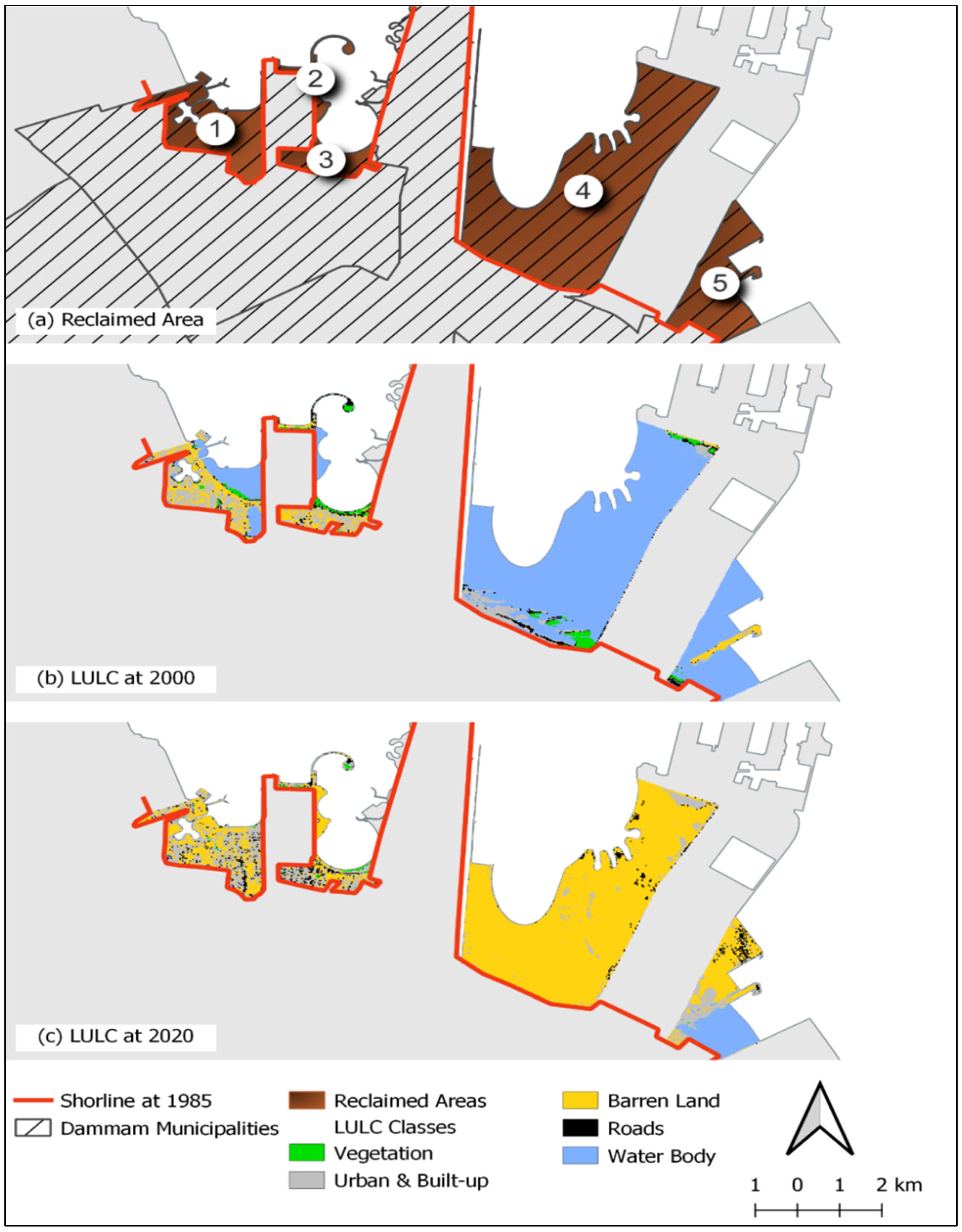
Following the production of the LULC thematic maps using supervised classification, post-classification change detection was used to identify changes between LULC in 2000 and 2020. Post-classification change detection is a simple change detection technique that provides a complete set of matrices for type and magnitude of inner-transition changes between LULC in different times [79]. Post-classification change detection was applied to the reclaimed areas.

4. Results

This section presents the findings of the analysis of the extent of coastal reclamation in DMA. It presents a succinct and precise description and interpretation of the results, which leads to discussing the environmental sustainability implications of the practice and drawing some conclusions.

4.1. LULC Supervised Classification

The LULC classification results of the remote sensing data in 2000 and 2020 using the SAM classifiers are displayed in Figure 4. Every class type can be visually identified on both dates. The dominant LULC class in 2000 is the water body, while in 2020, the barren land is the dominant LULC class.
Error matrices utilized to evaluate classification accuracy are summarized for 2000 and 2020 in Table 3 and Table 4, respectively. The overall accuracies for 2000 were 94.40% with a Kappa coefficient of 0.93 and for the accuracies for 2020 were 95.42% with Kappa coefficient of 0.94. Both tables indicate that user’s and producer’s accuracies of individual classes are consistently high, mostly greater than 90%.

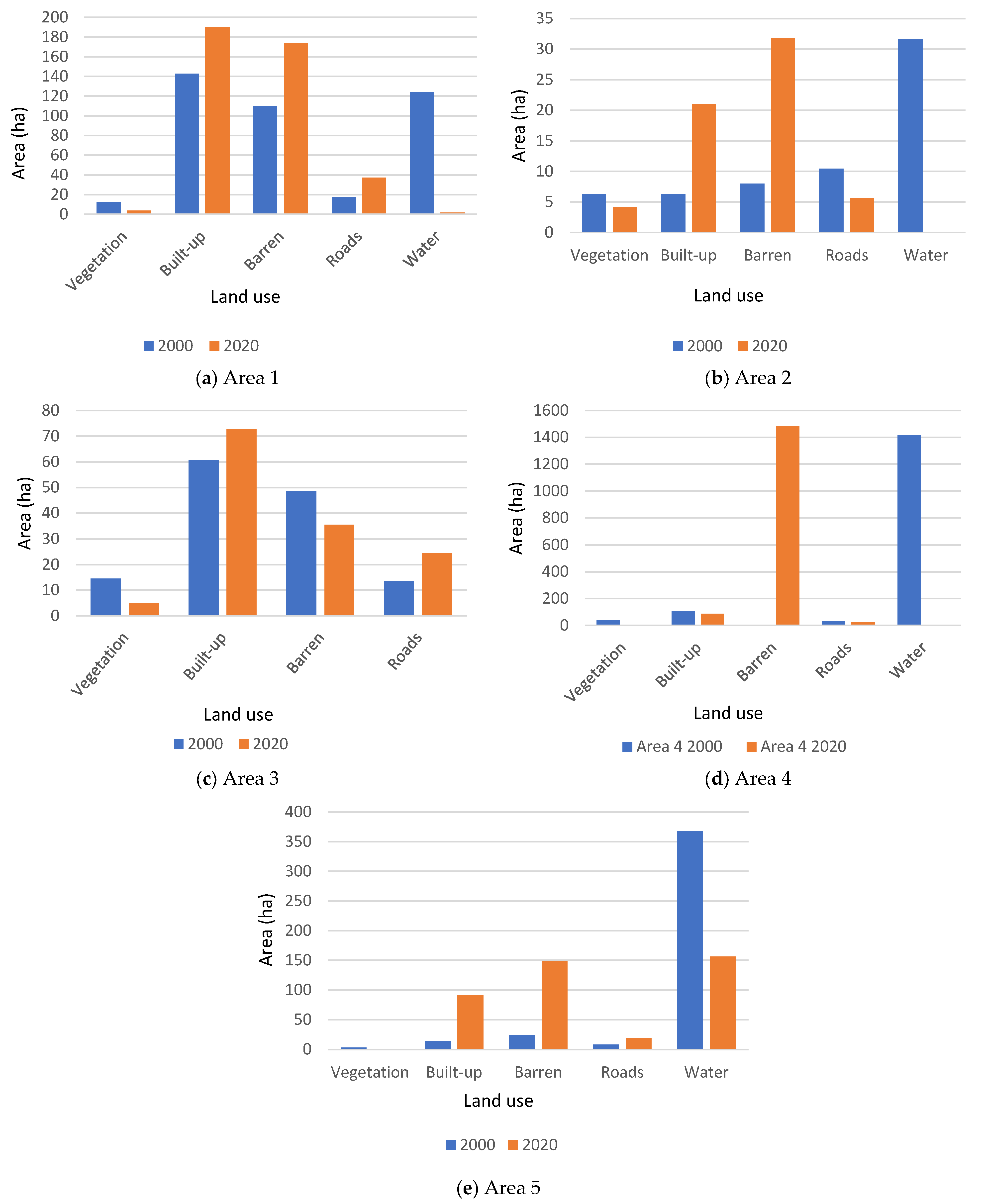
4.2. Change Detection Results

Comparing Dammam’s shoreline between 2000 and 2020 shows five areas reclaimed during this period (Figure 4a). Changes between different classes between 2000 and 2020 are summarized for each reclaimed area in Table 5. Diagonals of this table show the unchanged area of LULC class, while off diagonals values represent the interchanges from one class to another. The comparison of the LULC in the five coastal areas from 2000 to 2020 is shown in Figure 5.
In Area 1, 98.6% of the coastal sea area occupied by water in 2000 was reclaimed and transformed mainly into built-up and barren land in 2020. In Area 2, the whole seacoast area was reclaimed in 2020, and a major part of this reclaimed area was transformed into barren land. In Area 3, there was no coastal area. Otherwise, 66.5% of the area covered by the vegetation in 2000 was converted into built-up and barren land in 2020. In Area 4, the whole coastal area in 2000 was reclaimed in 2020 and converted mainly to barren land. For Area 5, about 57.5% of the area occupied by water and 89% occupied by vegetation in 2000 were converted to built-up and barren land in 2020.

5. Discussion: Environmental Sustainability Implications of Coastal Land Reclamation in DMA

The present study has considered the extent of coastal land reclamation in the DMA along the Arabian/Persian Gulf in Saudi Arabia. Five coastal areas that experienced substantial reclamation activities within the last two decades have been compared according to their change in LULC. Between 66.5% to 100% of the coastal areas occupied by water in 2000 have been reclaimed as of 2020, resulting in 6081 hectares of reclaimed land. Coastal vegetation has also been severely affected. The study found that the reclaimed areas have been converted into barren lands for future developments, road networks, and buildings mainly for recreational, residential, and commercial activities. Previous studies reported similar coastal reclamation drivers, including coastal economy, urban sprawl, and urbanization. In China’s coastal provinces and cities, about 754,697 ha of coastal wetlands have been reclaimed between 1985–2010 [30]. In Lagos, Nigeria, Eko Atlantic is an entirely new city built on reclaimed land along the Atlantic Ocean to house residential neighborhoods, recreation activities, and industries [80].
There are several environmental sustainability implications of coastal reclamation in DMA. Degradation and loss of ecosystem services and marine habitat [25] and risk of floods [19] have been associated with coastal reclamation in the study area. Seawater desalination is among the industrial activities located in reclaimed areas with negative environmental impacts such as water and air pollution [81]. Previous studies have also found several environmental implications of coastal land reclamation. In China, for instance, the loss of vast vegetated coastal wetlands and risks of coastal flooding are the negative environmental effects of large coastal reclamation projects [30]. The low resilience of reclaimed areas to earthquakes is another environmental and safety implication of coastal reclamation due to the instability of such lands and the geological characteristics of the Earth used for filling. However, observed seismic history records indicate that DMA has rarely seen any potential earthquake in the past. Therefore, the region can be categorized as immune or resistant to earthquakes.
Another possible environmental implication of this practice includes saltwater intrusion and the alteration of the quality of groundwater aquifers [5,82,83,84]. For example, the groundwater table in Eastern Province, where the study area is located, has been recently changing and significantly fluctuating [19]. Similarly, metal contamination has been reported in coastal sediments in Al-Khobar city in DMA [67]. However, despite increasing land reclamation activities in the area, it has been observed that saltwater intrusion has reduced significantly, indicating the practice has no known negative impact on groundwater quality [19].
Additional important impact of coastal reclamation is changing sea/ocean water levels and threats of storm surges and floods [52,53,85]. However, the literature has suggested that the oscillation of seawater levels in the Arabian Gulf does not show considerable change. Therefore, the region can also be categorized as a safe zone regarding stability from sea/ocean water level. However, coastal reclamation can prevent water waves from reaching the beach, thus, altering the natural coastal currents and sediments supply to wetlands [86,87]. In the Pudong district (China), for example, between 1989 and 2013, close to 20,000 ha of coastal wetlands were reclaimed (wetland loss at a rate of 3.8% per annum within the period), “thereby cutting off the exchange of sediment and water flux between the wetlands and the coastal ocean” [86] (p. 153).
Other factors threatening the sustainability of reclaimed land spaces are rainfall and wind. However, the region’s climatic conditions indicate that the area has an average rainfall of 80–88 mm and wind speed of 3–5 m per second, indicating no strong wind and storms that can pose a significant threat to coastal developments [65]. Therefore, the region can be classified as a safe zone as natural forces are likely to have little effect on the sustainability of new developments in the reclaimed coastal areas.
The literature reported the consequences of coastal land reclamation on the water habitat loss, water pollution, land subsidence, and coastal ecosystem degradation worldwide [9,30,88,89]. In DMA, coastal reclamation is reported to destroy mangrove swamps, coral reefs, and aquatic organisms [66,67]. The coastal land reclamation technique has obvious effects on the degradation of the environment of coastal water bodies; however, it can be sustained by proper environmental planning and management.
This section has discussed the environmental sustainability implications of coastal reclamation in the DMA compared to similar studies in other settings. Sustainable coastal land development requires environmental regulations to prohibit coastal reclamation because the metropolis has vast vacant land for development in other directions, especially on Riyadh, Jubail, and Alhasa highways. It can be concluded that it is difficult to ignore or reduce the degradation of marine habitat and ecosystem if coastal reclamation continues. Similarly, there is the need to embark on sustainable coastal environmental management through wetland regeneration in the coastal zone to restore the lost ecological services. This recommendation can be achieved through landscaping, creating ponds, and green areas in the reclaimed areas [86].

6. Conclusions

The rising demand for land resources due to the rapid rate of urbanization is increasing the rates of coastal reclamation globally. In Saudi Arabia, coastal reclamation is increasingly utilized as an urbanization strategy for socioeconomic development, including residential, commercial, industrial, and leisure activities in coastal settlements, especially in DMA and Jeddah coastal metropolis. Although this land use practice has some economic benefits to the locality, it has been associated with adverse environmental impacts. The present study has assessed the extent of coastal land reclamation in DMA within the last two decades, achieving LULC classification accuracy between 94.4 and 95.4%. The five areas investigated have experienced between 66.5% and 100% of their total water surface and marine vegetation reclaimed within two decades. There are several likely sustainability implications of such a practice.
Coastal land reclamation is a land-use practice that has been associated with loss and damage to biodiversity and ecosystem services, marine habitat fragmentation and degradation, water pollution, and altering the water cycle and the lives of plants, animals, and people that depend directly or indirectly on the water. The major ecological resources and habitats in the DMA coastal region that are negatively impacted by coastal reclamation include coral reefs, mangrove forests, and seagrass beds, which must be protected against extinction due to land reclamation activities. Despite the economic benefits of coastal reclamation, such as job creation, it is difficult to ignore its environmental impacts on marine habitat and ecosystem.
Therefore, it is imperative to strike a balance between pursuing economic development and preserving the local ecological system. An effective land reclamation policy and strategy are not available for the DMA region, which needs immediate consideration by the municipality. Thus, there is a need to develop a policy on strict prohibition of coastal reclamation in the country to preserve the coastal ecosystem. Furthermore, the wetland regeneration strategy in the coastal zone needs to be adopted and implemented. An example of sustainable coastal reclamation policies being implemented in Indonesia is allowing limited land reclamation to serve very important national interest such as seaports, and totally forbidden reclamation of sensitive ecosystems such as coral reefs, mangroves, and marine parks [90]. Both policies can be adapted in DMA to reduce the risks of harmful impacts of coastal land reclamation on the environment. Sustainable coastal land development is vital to promoting urban sustainability.
A limitation of the present study is the use of LANDSAT imageries, which has medium resolution that lacks the capability to detect maximum wetlands’ exposure, although it is popular due to its zero cost, providing long-term time series data, and global coverage. Therefore, a study using better resolution satellite imageries can address this drawback. Similarly, future studies are required to assess the consequences of coastal reclamation on marine habitat and coastal ecosystem in DMA compared to the economic gains of the practice. The opinion of DMA residents can also be surveyed to ascertain the extent to which they accept the practice and its perceived impacts on their quality of life.
In conclusion, the current study could alert policy makers in the MoMRA and DMA Municipality (authorities responsible for managing urban development in the study area) about the ecological risks associated with coastal land reclamation in DMA and policies for sustainable coastal development. Achieving urban sustainability requires development policy that protects the environment while promoting economic growth. Another implication of this study is that it can stimulate academic researchers to embark on more local studies on the subject. It will give them some hints on how to access free satellite imageries for related studies. The study can also serve as a basis and resource for further studies by academics and researchers interested in assessing the extent of coastal land reclamation and its impacts on the ecosystem.

Author Contributions

Conceptualization, A.M.A.; methodology, E.M.E.A. and W.E.M.M.; software, E.M.E.A. and W.E.M.M.; validation, E.M.E.A. and W.E.M.M.; formal analysis, I.R.A. and U.L.D.; investigation, U.L.D. and I.R.A.; resources, W.A.G.A.-G., M.S.A. and N.A.; data curation, E.M.E.A. and W.E.M.M.; writing—original draft preparation, A.M.A.; writing—review and editing, I.R.A. and U.L.D.; supervision, I.R.A. and U.L.D.; project administration, A.M.A. All authors have read and agreed to the published version of the manuscript.

Funding

This research received no external funding.

Institutional Review Board Statement

Not applicable.

Informed Consent Statement

Not applicable.

Data Availability Statement

No new data were created or analyzed in this study. Data sharing is not applicable to this article.

Conflicts of Interest

The authors declare no conflict of interest.

References

  1. World Resources Institute (WRI). Pilot Analysis of Globe Ecosystems: Coastal Ecosystems; WRI Publication: Washington, DC, USA, 2001. [Google Scholar]
  2. Feng, L.; Zhu, X.; Sun, X. Assessing coastal reclamation suitability based on a fuzzy-AHP comprehensive evaluation framework: A case study of Lianyungang, China. Mar. Pollut. Bull. 2014, 89, 102–111. [Google Scholar] [CrossRef] [PubMed]
  3. Sengupta, D.; Chen, R.; Meadows, M.E. Building beyond land: An overview of coastal land reclamation in 16 global megacities. Appl. Geogr. 2018, 90, 229–238. [Google Scholar] [CrossRef]
  4. Pew Oceans Commission (POC). America’s Living Oceans: Charting a Course for Sea Change (POC, Arlington, VA). 2003. Available online: https://www.pewtrusts.org/~/media/assets/2003/06/02/poc_summary.pdf (accessed on 20 May 2022).
  5. Naser, H.; Hoad, G. An investigation of salinity tolerance and salt secretion in protected mangroves, Bahrain. In Proceedings of the Gulf II: An International Conference—The State of the Gulf Ecosystem: Functioning and Services, Kuwait City, Kuwait, 7–9 February 2011; pp. 7–9. [Google Scholar]
  6. Halpern, B.S.; Walbridge, S.; Selkoe, K.A.; Kappel, C.V.; Micheli, F.; D’Agrosa, C.; Watson, R. A global map of human impact on marine ecosystems. Science 2008, 319, 948–952. [Google Scholar] [CrossRef] [PubMed]
  7. Naser, H.A. The role of environmental impact assessment in protecting coastal and marine environments in rapidly developing islands: The case of Bahrain, Arabian Gulf. Ocean Coast. Manag. 2015, 104, 159–169. [Google Scholar] [CrossRef]
  8. Hamza, W.; Munawar, M. Protecting and managing the Arabian Gulf: Past, present and future. Aquat. Ecosyst. Health Manag. 2009, 12, 429–439. [Google Scholar] [CrossRef]
  9. Duan, H.; Zhang, H.; Huang, Q.; Zhang, Y.; Hu, M.; Niu, Y.; Zhu, J. Characterization and environmental impact analysis of sea land reclamation activities in China. Ocean Coast. Manag. 2016, 130, 128–137. [Google Scholar] [CrossRef]
  10. Li, F.; Ding, D.; Chen, Z.; Chen, H.; Shen, T.; Wu, Q.; Zhang, C. Change of sea reclamation and the sea-use management policy system in China. Mar. Policy 2020, 115, 103861. [Google Scholar] [CrossRef]
  11. Stocker, T. Climate Change 2013: The Physical Science Basis, Working Group I Contribution to the Fifth Assessment Report of the Intergovernmental Panel on Climate Change; Cambridge University Press: Cambridge, UK, 2014. [Google Scholar]
  12. Garner, A.J.; Mann, M.E.; Emanuel, K.A.; Kopp, R.E.; Lin, N.; Alley, R.B.; Pollard, D. Impact of climate change on New York City’s coastal flood hazard: Increasing flood heights from the preindustrial to 2300 CE. Proc. Natl. Acad. Sci. USA 2017, 114, 11861–11866. [Google Scholar] [CrossRef]
  13. Marsooli, R.; Lin, N.; Emanuel, K.; Feng, K. Climate change exacerbates hurricane flood hazards along US Atlantic and Gulf Coasts in spatially varying patterns. Nat. Commun. 2019, 10, 1–9. [Google Scholar] [CrossRef]
  14. Vousdoukas, M.I.; Mentaschi, L.; Voukouvalas, E.; Bianchi, A.; Dottori, F.; Feyen, L. Climatic and socioeconomic controls of future coastal flood risk in Europe. Nat. Clim. Change 2018, 8, 776–780. [Google Scholar] [CrossRef]
  15. Peduzzi, P.; Chatenoux, B.; Dao, H.; De Bono, A.; Herold, C.; Kossin, J.; Nordbeck, O. Global trends in tropical cyclone risk. Nat. Clim. Change 2012, 2, 289–294. [Google Scholar] [CrossRef]
  16. Forman, R.T.; Wu, J. Where to put the next billion people. Nature 2016, 537, 608–611. [Google Scholar] [CrossRef]
  17. Xu, L.; Ding, S.; Nitivattananon, V.; Tang, J. Long-Term Dynamic of Land Reclamation and Its Impact on Coastal Flooding: A Case Study in Xiamen, China. Land 2021, 10, 866. [Google Scholar] [CrossRef]
  18. Reyna, J.; Bera, A.; Cho, H.Y.; Wilson, W.D.; Folorunsho, R.; Green, S.; Tuhumwire, J. Land-Sea Physical Interaction. In The First Global Integrated Marine Assessment: World Ocean Assessment I; United Nations: New York, NY, USA, 2016. [Google Scholar]
  19. Dano, U.L. An AHP-based assessment of flood triggering factors to enhance resiliency in Dammam, Saudi Arabia. GeoJournal 2021, 87, 1945–1960. [Google Scholar] [CrossRef]
  20. Dano, U.L. Flash flood impact assessment in Jeddah City: An analytic hierarchy process approach. Hydrology 2020, 7, 10. [Google Scholar] [CrossRef]
  21. Dawod, G.M.; Mirza, M.N.; Al-Ghamdi, K.A. GIS-based estimation of flood hazard impacts on road network in Makkah city, Saudi Arabia. Environ. Earth Sci. 2012, 67, 2205–2215. [Google Scholar] [CrossRef]
  22. Ledraa, T.A.; Al-Ghamdi, A.M. Planning and management issues and challenges of flash flooding disasters in Saudi Arabia: The case of Riyadh City. J. Archit. Plan 2020, 32, 155–171. [Google Scholar]
  23. Radwan, F.; Alazba, A.A.; Mossad, A. Flood risk assessment and mapping using AHP in arid and semiarid regions. Acta Geophys. 2019, 67, 215–229. [Google Scholar] [CrossRef]
  24. Youssef, A.M.; Sefry, S.A.; Pradhan, B.; Alfadail, E.A. Analysis on causes of flash flood in Jeddah city (Kingdom of Saudi Arabia) of 2009 and 2011 using multi-sensor remote sensing data and GIS. Geomat. Nat. Hazards Risk 2016, 7, 1018–1042. [Google Scholar] [CrossRef]
  25. Almahasheer, H.; Al-Taisan, W.; Mohamed, M.K. Mangrove deterioration in Tarut Bay on the eastern province of the Kingdom of Saudi Arabia. Pakhtunkhwa J. Life Sci 2013, 1, 49–59. [Google Scholar]
  26. Suzuki, T. Economic and geographic backgrounds of land reclamation in Japanese ports. Mar. Pollut. Bull. 2003, 47, 226–229. [Google Scholar] [CrossRef]
  27. Hoeksema, R.J. Three stages in the history of land reclamation in The Netherlands. Irrig. Drain. Eng. 2007, 56, 113–126. [Google Scholar] [CrossRef]
  28. Kennish, M.J. Coastal salt marsh systems in the US: A review of anthropogenic impacts. J. Coast. Res. 2001, 17, 731–748. [Google Scholar]
  29. Wang, W.; Liu, H.; Li, Y.; Su, J. Development and management of land reclamation in China. Ocean Coast. Manag. 2014, 102, 415–425. [Google Scholar] [CrossRef]
  30. Tian, B.; Wu, W.; Yang, Z.; Zhou, Y. Drivers, trends, and potential impacts of long-term coastal reclamation in China from 1985 to 2010. Estuar. Coast. Shelf Sci. 2016, 170, 83–90. [Google Scholar] [CrossRef]
  31. He, Q.; Bertness, M.D.; Bruno, J.F.; Li, B.; Chen, G.; Coverdale, T.C.; Altieri, A.H.; Bai, J.; Sun, T.; Pennings, S.C.; et al. Economic development and coastal ecosystem change in China. Sci. Rep. 2014, 4, 5995. [Google Scholar] [CrossRef]
  32. Loures, L.; Crawford, P. Democracy in progress: Using public participation in post-industrial landscape (re)-development. WSEAS Trans. Environ. Dev. 2008, 4, 794–803. [Google Scholar]
  33. Zhang, Y.; Chen, R.; Wang, Y. Tendency of land reclamation in coastal areas of Shanghai from 1998 to 2015. Land Use Policy 2020, 91, 104370. [Google Scholar] [CrossRef]
  34. Suo, A.; Zhang, M. Sea areas reclamation and coastline change monitoring by remote sensing in coastal zone of Liaoning in China. J. Coast. Res. 2015, 73, 725–729. [Google Scholar] [CrossRef]
  35. Wang, X.G.; Su, F.Z.; Zhang, J.J.; Cheng, F.; Hu, W.Q.; Ding, Z. Construction land sprawl and reclamation in the Johor River Estuary of Malaysia since 1973. Ocean Coast. Manag. 2019, 171, 87–95. [Google Scholar] [CrossRef]
  36. Sengupta, D.; Chen, R.; Meadows, M.E.; Choi, Y.R.; Banerjee, A.; Zilong, X. Mapping trajectories of coastal land reclamation in nine deltaic megacities using Google Earth Engine. Remote Sens. 2019, 11, 2621. [Google Scholar] [CrossRef]
  37. Meng, W.; Hu, B.; He, M.; Liu, B.; Mo, X.; Li, H.; Zhang, Y. Temporal-spatial variations and driving factors analysis of coastal reclamation in China. Estuar. Coast. Shelf Sci. 2017, 191, 39–49. [Google Scholar] [CrossRef]
  38. Liu, T.-K.; Huang, H.-Y.; Hsu, S.-L. Saving the critically endangered Chinese white dolphin in Taiwan: Debate regarding the designation of an MPA. Mar. Policy 2015, 61, 113–120. [Google Scholar] [CrossRef]
  39. Yang, H.Y.; Chen, B.; Barter, M.; Piersma, T.; Zhou, C.F.; Li, F.S.; Zhang, Z.W. Impacts of tidal land reclamation in Bohai Bay, China: Ongoing losses of critical. Yellow Sea waterbird staging and wintering sites. Bird Conserv. Int. 2011, 21, 241–259. [Google Scholar] [CrossRef]
  40. Bai, Q.; Chen, J.; Chen, Z.; Dong, G.; Dong, J.; Dong, W.; Fu, V.W.K.; Han, Y.; Lu, G.; Li, J. Identification of coastal wetlands of international importance for waterbirds: A review of China Coastal Waterbird Surveys 2005-2013. Avian Res. 2015, 6, 12. [Google Scholar] [CrossRef]
  41. Wu, Q.; Tam, N.F.Y.; Leung, J.Y.S.; Zhou, X.; Jie, F.; Bo, Y.; Huang, X.; Xia, L. Ecological risk and pollution history of heavy metals in Nansha mangrove, South China. Ecotoxicol. Environ. Saf. 2014, 104, 143–151. [Google Scholar] [CrossRef]
  42. Li, H.; Chen, G. Genetic variation within the endangered mangrove species Sonneratia paracaseolaris (Sonneratiaceae) in China detected by inter-simple sequence repeats analysis. Biochem. Syst. Ecol. 2009, 37, 260–265. [Google Scholar] [CrossRef]
  43. Jian, S.; Ban, J.; Ren, H.; Yan, H. Low genetic variation detected within the widespread mangrove species Nypa fruticans (Palmae) from Southeast Asia. Aquat. Bot. 2010, 92, 23–27. [Google Scholar] [CrossRef]
  44. Nanfang Metropolis Daily News. A Serious Foundation Pit Slope Sliding Accident Resulted from the Soft Soil—A Construction Site at Qianhai Zone in Shenzhen. 2015. Available online: http://sz.house.qq.com/a/20150712/008933_1.htm (accessed on 2 July 2021).
  45. Reclaimed Land Geological Research (RLGR). Ground failures on reclaimed land during the 2011 Tohoku earthquake: A case study in urayasu city, Japan. Quat. Int. 2016, 397, 555–562. [Google Scholar] [CrossRef]
  46. Jiang, P.; Cheng, L.; Li, M.; Zhao, R.; Huang, Q. Analysis of landscape fragmentation processes and driving forces in wetlands in arid areas: A case study of the middle reaches of the Heihe River, China. Ecol. Indic. 2014, 46, 240–252. [Google Scholar] [CrossRef]
  47. Jiang, T.T.; Pan, J.F.; Pu, X.M.; Wang, B.; Pan, J.J. Current status of coastal wetlands in China: Degradation, restoration, and future management. Estuarine. Coast. Shelf Sci. 2015, 164, 265–275. [Google Scholar] [CrossRef]
  48. CU. New Global Maps Detail Human-Caused Ocean Acidification, the Earth Institute (Columbia University). 2014. Available online: http://www.earthinstitute.columbia.edu/articles/view/3211 (accessed on 2 July 2021).
  49. Guo, H.; Jiao, J.J. Impact of coastal land reclamation on ground water level and the sea water interface. Ground Water 2007, 45, 362–367. [Google Scholar] [CrossRef] [PubMed]
  50. Kouping, C.; Jiao, J.J. Metal concentrations and mobility in marine sediment and groundwater in coastal reclamation areas: A case study in Shenzhen, China. Environ. Pollut. 2008, 151, 576–584. [Google Scholar]
  51. Li, J.; Pu, L.; Zhu, M.; Zhang, J.; Li, P.; Dai, X.; Xu, Y.; Liu, L. Evolution of soil properties following reclamation in coastal areas: A review. Geodermas 2014, 226, 130–139. [Google Scholar] [CrossRef]
  52. Ding, Y.; Wei, H. Modeling the impact of land reclamation on storm surges in Bohai Sea, China. Nat. Hazards 2017, 85, 559–573. [Google Scholar] [CrossRef]
  53. Gao, G.D.; Wang, X.H.; Bao, X.W. Land reclamation and its impact on tidal dynamics in Jiaozhou Bay, Qingdao, China. Estuar. Coast. Shelf Sci. 2014, 151, 285–294. [Google Scholar] [CrossRef]
  54. Song, D.; Wang, X.H.; Zhu, X.; Bao, X. Modeling studies of the far-field effects of tidal flat reclamation on tidal dynamics in the East China Seas. Estuar. Coast. Shelf Sci. 2013, 133, 147–160. [Google Scholar] [CrossRef]
  55. Benassai, G.; Di Paola, G.; Aucelli, P.P.C. Coastal risk assessment of a micro-tidal littoral plain in response to sea-level rise. Ocean Coast. Manag. 2015, 104, 22–35. [Google Scholar] [CrossRef]
  56. Huang, Z.; Zong, Y.; Zhang, W. Coastal inundation due to sea-level rise in the Pearl River Delta, China. Nat. Hazards 2004, 33, 247–264. [Google Scholar] [CrossRef]
  57. Neumann, J.E.; Emanuel, K.A.; Ravela, S.; Ludwig, L.C.; Verly, C. Risks of coastal storm surge and the effect of sea-level rise in the Red River Delta, Vietnam. Sustainability 2015, 7, 6553–6572. [Google Scholar] [CrossRef]
  58. Rizzi, J.; Torresan, S.; Zabeo, A.; Critto, A.; Tosoni, A.; Tomasin, A.; Marcomini, A. Assessing storm surge risk under future sea-level rise scenarios: A case study in the North Adriatic coast. J. Coast. Conserv. 2017, 21, 453–471. [Google Scholar] [CrossRef]
  59. Du, S.; Scussolini, P.; Ward, P.J.; Zhang, M.; Wen, J.; Wang, L.; Aerts, J.C. Hard or soft flood adaptation? Advantages of a hybrid strategy for Shanghai. Glob. Environ. Change 2020, 61, 102037. [Google Scholar] [CrossRef]
  60. Wang, J.; Gao, W.; Xu, S.; Yu, L. Evaluation of the combined risk of sea-level rise, land subsidence, and storm surges on the coastal areas of Shanghai, China. Clim. Change 2012, 115, 537–558. [Google Scholar] [CrossRef]
  61. Yin, J.; Yin, Z.E.; Hu, X.M.; Xu, S.Y.; Wang, J.; Li, Z.H.; Gan, F.B. Multiple scenario analyses forecasting the confounding impacts of sea-level rise and tides from storm induced coastal flooding in the city of Shanghai, China. Environ. Earth Sci. 2011, 63, 407–414. [Google Scholar] [CrossRef]
  62. Yin, J.; Yu, D.; Yin, Z.; Wang, J.; Xu, S. Modelling the combined impacts of sea-level rise and land subsidence on storm tides induced flooding of the Huangpu River in Shanghai, China. Clim. Change 2013, 119, 919–932. [Google Scholar] [CrossRef]
  63. Abou-Korin, A.A.; Al-Shihri, F.S. Rapid urbanization and sustainability in Saudi Arabia: The case of Dammam metropolitan area. J. Sust. Dev. 2015, 8, 52. [Google Scholar]
  64. Alqahtany, A. Developing a consensus-based measures for housing delivery in Dammam metropolitan area, Saudi Arabia. Int. J. Hous. Mark. Anal. 2019, 12, 226–245. [Google Scholar] [CrossRef]
  65. AlQahtany, A.M.; Abubakar, I.R. Public perception and attitudes to disaster risks in a coastal metropolis of Saudi Arabia. Intl. J. Disaster Risk Reduct. 2020, 44, 101422. [Google Scholar] [CrossRef]
  66. Local Weather. Dammam Climate History, N.D. Available online: http://www.myweather2.com/City-Town/Saudi-Arabia/Dammam/climate-profile.aspx (accessed on 5 January 2020).
  67. MMRA; UN-Habitat. Dammam City Profile: Future Saudi Cities Programme; Ministry of Municipal and Rural Affairs: Riyadh, Saudi Arabia, 2019; Available online: https://unhabitat.org/sites/default/files/2020/04/dammam.pdf (accessed on 18 June 2021).
  68. Alharbi, T.; El-Sorogy, A. Assessment of metal contamination in coastal sediments of Al-Khobar area, Arabian Gulf, Saudi Arabia. J. Afr. Earth Sci. 2017, 129, 458–468. [Google Scholar] [CrossRef]
  69. Dano, U.L.; AlQahtany, A.M. Issues undermining public transport utilization in Dammam city, Saudi Arabia: An expert-based analysis. J. Sustain. Sci. Manag. 2019, 14, 155–169. [Google Scholar]
  70. Alhowaish, A.K. Eighty years of urban growth and socioeconomic trends in Dammam Metropolitan Area, Saudi Arabia. Habitat Int. 2015, 50, 90–98. [Google Scholar] [CrossRef]
  71. Al-Shihri, F.S. Impacts of large-scale residential projects on urban sustainability in Dammam Metropolitan Area, Saudi Arabia. Habitat Int. 2016, 56, 201–211. [Google Scholar] [CrossRef]
  72. USGS. EarthExplorer; General Information Product 136; U.S. Geological Survey: Reston, VA, USA, 2012.
  73. USGS. Landsat 7 (L7) Data Users Handbook; LSDS-1927 Version 2.0; U.S. Geological Survey (USGS): Sioux Falls, SD, USA, 2019. Available online: https://www.usgs.gov/media/files/landsat-7-data-users-handbook (accessed on 26 December 2020).
  74. USGS. Landsat 8 (L8) Data Users Handbook; LSDS-1574 Version 5.0; U.S. Geological Survey (USGS): Sioux Falls, SD, USA, 2019. Available online: https://www.usgs.gov/media/files/landsat-8-data-users-handbook (accessed on 26 December 2020).
  75. Campbell, J.B.; Wynne, R.H. Introduction to Remote Sensing, 5th ed.; Guilford Press: New York, NY, USA, 2011. [Google Scholar]
  76. Liu, Y.; Lu, S.; Lu, X.; Wang, Z.; Chen, C.; He, H. Classification of urban hyperspectral remote sensing imagery based on optimized spectral angle mapping. J. Indian Soc. Remote Sens. 2019, 47, 289–294. [Google Scholar] [CrossRef]
  77. Deliry, S.I.; Avdan, Z.Y.; Avdan, U. Extracting urban impervious surfaces from Sentinel-2 and Landsat-8 satellite data for urban planning and environmental management. Envi. Sci. Pollut. Res. 2021, 28, 6572–6586. [Google Scholar] [CrossRef]
  78. Talukdar, S.; Singha, P.; Mahato, S.; Pal, S.; Liou, Y.A.; Rahman, A. Land-use land-cover classification by machine learning classifiers for satellite observations—A review. Remote Sens. 2020, 12, 1135. [Google Scholar] [CrossRef]
  79. Hussain, M.; Chen, D.; Cheng, A.; Wei, H.; Stanley, D. Change detection from remotely sensed images: From pixel-based to object-based approaches. ISPRS J. Photogram. Remote Sens. 2013, 80, 91–106. [Google Scholar] [CrossRef]
  80. Dano, U.L.; Balogun, A.L.; Abubakar, I.R.; Aina, Y.A. Transformative urban governance: Confronting urbanization challenges with geospatial technologies in Lagos, Nigeria. GeoJournal 2020, 85, 1039–1056. [Google Scholar] [CrossRef]
  81. Abubakar, I.R.; Mu’azu, N.D. Household attitudes toward wastewater recycling in Saudi Arabia. Util. Policy 2022, 76, 101372. [Google Scholar] [CrossRef]
  82. Leal Filho, W.; Abubakar, I.R.; Nunes, C.; Platje, J.; Ozuyar, P.G.; Will, M.; Nagy, G.J.; Al-Amin, A.Q.; Hunt, J.D.; Li, C. Deep seabed mining: A note on some potentials and risks to the sustainable mineral extraction from the oceans. J. Mar. Sci. Eng. 2021, 9, 521. [Google Scholar] [CrossRef]
  83. Akbar, N.; Abubakar, I.R.; Bouregh, A.S. Fostering Urban Sustainability through the Ecological Wisdom of Traditional Settlements. Sustainability 2020, 12, 10033. [Google Scholar] [CrossRef]
  84. Zhang, X.; Hu, B.X.; Wang, P.; Chen, J.; Yang, L.; Xiao, K.; Zhang, X. Hydrogeochemical evolution and heavy metal contamination in groundwater of a reclaimed land on Zhoushan Island. Water 2018, 10, 316. [Google Scholar] [CrossRef]
  85. Mancini, C.P.; Lollai, S.; Volpi, E.; Fiori, A. Flood modeling and groundwater flooding in urbanized reclamation areas: The case of Rome (Italy). Water 2020, 12, 2030. [Google Scholar] [CrossRef]
  86. Wu, W.; Yang, Z.; Tian, B.; Huang, Y.; Zhou, Y.; Zhang, T. Impacts of coastal reclamation on wetlands: Loss, resilience, and sustainable management. Estuar. Coast. Shelf Sci. 2018, 210, 153–161. [Google Scholar] [CrossRef]
  87. Ghazali, N.H.M. Coastal erosion and reclamation in Malaysia. Aquat. Ecosyst. Health Manag. 2006, 9, 237–247. [Google Scholar] [CrossRef]
  88. Sengupta, D.; Chen, R.; Meadows, M.E.; Banerjee, A. Gaining or losing ground? Tracking Asia’s hunger for ‘new’ coastal land in the era of sea level rise. Sci. Total Environ. 2020, 732, 139–290. [Google Scholar] [CrossRef]
  89. Feng, T.; Xu, N. Satellite-based monitoring of annual coastal reclamation in Shenzhen and Hong Kong since the 21st Century: A comparative study. J. Mar. Sci. Eng. 2021, 9, 48. [Google Scholar] [CrossRef]
  90. Turisno, B.E.; Dew, I.G.A.G.S. Impact of coastal reclamation on environmental sustainability and tourism-based economy on the north coast of Java. Int. J. Criminol. Sociol. 2021, 10, 695–702. [Google Scholar] [CrossRef]
Figure 1. Map of DMA, Saudi Arabia (Source: [69]).
Water 14 02546 g001
Figure 2. Some examples of the different type of coastlines in DMA, the picture on the left shows the mangrove vegetation on the coastline (Source: [67]).
Water 14 02546 g002
Figure 3. Examples of coastal land reclamation and destruction of mangrove forests in the study area (Source: [67]).
Water 14 02546 g003
Figure 4. Reclaimed areas and LULC Classifications: (a) Reclaimed areas as obtained from the official shoreline vector, (b) LULC classification results for 2000, and (c) LULC classification results for 2020.
Water 14 02546 g004
Figure 5. Comparative analysis of LULC in the five coastal areas in DMA, 2000–2020.
Water 14 02546 g005
Table 1. Spatial and spectral characteristics for LANDSAT 7 ETM+ and LANDSAT 8 OLI/TIRS (adopted from [73] (p. 7), [74] (p. 8)).
LANDSAT 7 ETM+LANDSAT 8 OLI/TIRS
BandWavelength (μm)Spatial Resolution (m)BandWavelength (μm)Spatial Resolution (m)
Band 1–blue0.45–0.52 Band 1–coastal aerosol0.43–0.45
Band 2–green0.52–0.6030Band 2–blue0.45–0.51
Band 3–red0.63–0.69 Band 3–green0.53–0.59
Band 4–Near Infrared0.77–0.90 Band 4–red0.64–0.67
Band 5–Short-wave Infrared1.55–1.75 Band 5–Near Infrared (NIR)0.85–0.88
Band 6–Thermal Infrared10.40–12.5060Band 6–Short-wave Infrared (SWIR) 11.57–1.6530
Band 7–Short-wave Infrared2.09–2.3530Band 7–Short-wave Infrared (SWIR) 22.11–2.29
Band 8–Panchromatic0.52–0.9015Band 8–Panchromatic0.50–0.6815
Band 9–Cirrus1.36–1.3830
Band 10–TIRS 110.60–11.19100
Band 11–TIRS 211.50–12.51
Table 2. LULC Classification Scheme.
ClassDescription
VegetationArea predominantly covered with natural or man-made vegetation.
Built-upArea developed with building materials
BarrenArea predominantly with bare soil around the year.
RoadsArea developed with an impervious surface such as asphalt for transportation purposes.
WaterArea covered by water year around.
Table 3. Error matrix, producer’s accuracy, and user’s accuracy for LULC classification of LANDSAT 7 ETM+.
Validation DataProducer’s AccuracyUser’s Accuracy
VegetationBuilt-UpBarrenRoadsWaterTotal
Classified DataVegetation4801015096.00%96.00%
Built-up0482205296.00%92.31%
Barren1145204990.00%91.84%
Roads0114604892.00%95.83%
Water1010495198.00%96.08%
Total5050505050250
Table 4. Error matrix, producer’s accuracy, and user’s accuracy for LULC classification of LANDSAT 8OLI/TIRS.
Validation DataProducer’s AccuracyUser’s Accuracy
VegetationBuilt-UpBarrenRoadsWaterTotal
Classified DataVegetation4500014690.00%97.83%
Built-up0451104790.00%95.74%
Barren1249205498.00%90.74%
Roads0114104382.00%95.35%
Water1000495098.00%98.00%
Total4748514450240
Table 5. Transition matrix of LULC from 2000 to 2020 within Dammam reclaimed coastal regions in hectares.
LULC 2000LULC 2020Total
Reclaimed Area 1VegetationBuilt-UpBarrenRoadsWater
Vegetation1.46.33.60.70.012.1
Built-up0.664.164.412.51.2142.8
Barren0.852.844.012.00.1109.7
Roads0.19.55.12.70.317.7
Water0.757.056.59.30.2123.7
Total3.7189.7173.737.21.7406.0
Reclaimed Area 2
Vegetation3.82.20.10.30.06.3
Built-up0.33.61.41.10.06.3
Barren0.14.52.41.00.08.0
Roads0.15.22.32.80.010.4
Water0.05.625.60.50.031.7
Total4.221.131.85.70.062.7
Reclaimed Area 3
Vegetation3.85.04.90.80.014.5
Built-up0.532.517.310.40.060.6
Barren0.528.211.68.50.048.7
Roads0.27.01.74.80.013.7
Water0.00.00.00.00.00.0
Total4.972.735.524.40.0137.4
Reclaimed Area 4
Vegetation0.07.531.30.00.038.8
Built-up0.011.289.32.90.0103.3
Barren0.01.71.80.50.04.1
Roads0.07.722.91.40.032.0
Water0.058.21339.716.70.31415.0
Total0.086.31485.021.50.31593.1
Reclaimed Area 5
Vegetation0.01.51.40.00.43.2
Built-up0.05.63.40.15.014.1
Barren0.015.46.81.10.323.6
Roads0.05.92.10.00.38.2
Water0.463.5135.817.9150.7368.3
Total0.491.9149.519.1156.6417.4
Publisher’s Note: MDPI stays neutral with regard to jurisdictional claims in published maps and institutional affiliations.

