
Inland Navigation as an Opportunity to Increase the Cargo Capacity of the Tri-City Seaports


Faculty of Navigation, Gdynia Maritime University, 81-225 Gdynia, Poland
*
Author to whom correspondence should be addressed.
Water 2022, 14(16), 2482; https://doi.org/10.3390/w14162482
Submission received: 5 April 2022
/
Revised: 2 August 2022
/
Accepted: 5 August 2022
/
Published: 12 August 2022
(This article belongs to the Special Issue Port Structures, Maritime Transport and Tourism)
Abstract
:The aim of the article is to analyse the transport accessibility of the Tri-City seaports as well as to verify the necessity of starting the inland navigation. The proposal to develop inland navigation by creating new and developing existing waterways is supported by the idea of sustainable transport, which emphasizes how important it is to improve the efficiency of transport work and to minimize the harmful impact of transport on the environment. The purpose of the study is to determine the capability to increase the cargo capacity of the Port of Gdansk and the Port of Gdynia. The article presents the results of the operational analysis from the navigation and manoeuvring simulator Navi-Trainer Professional 5000, where scenarios that the barge from Tri-City seaports reaches the planned dry port in Zajączkowo Tczewskie have been made. This concept intends to verify the option of relieving truck traffic in the Tri-City area.
1. Introduction
Transhipment in the Tri-City seaports has been growing every year. In addition to servicing the Polish market, it also helps with handling and distribution of goods to the neighbouring countries. The facilities of the ports of Gdansk and Gdynia are mainly based on the use of road transport, but the constant increase in the ports’ turnover leads to the growth of the number of large goods vehicles, which cause considerable congestion. The progressive trend in the transhipment at the Port of Gdansk and at the Port of Gdynia has caused the roads to become insufficient to deliver cargo to the inland areas of the country in a smooth way [1]. When describing the rail transport in servicing the ports of Gdansk and Gdynia, it can be stated that despite several modernizations, it still does not have sufficient capacity. This concerns not only rush hour but also the other time periods besides it. It is important to mention that properly prospering transport facilities of the ports allow to determine its high competitiveness, which consists of handling a large amount of cargo in comparison to the ports located in close proximity, and it is also characterized by a high level of security. Therefore, in order to provide a well-functioning port’s base, it is worth considering the modernization of existing waterways but also creating new ones.
The aim of the study was to determine the possibility of increasing the cargo capacity of the Port of Gdansk and the Port of Gdynia (see Figure 1) in accordance with the vision of cargo transport by inland waterway [2]. The article presents the results of an operational analysis from Navi-Trainer Professional 5000, the navigation and manoeuvring simulator, where scenarios of the barge departing from the Tri-City seaports and arriving to the planned dry port in Zajączkowo Tczewskie have been made. This concept intends to verify the option of relieving truck traffic in the Tri-City area [3].
In the first part of the article, the analysis of the transport accessibility of Tri-City seaports is presented. The analysis covers road transport, rail transport, and maritime transport. Autonomous transport modes [4,5,6] can also be analysed in our framework. The next part of the article consists of a simulation analysis, which have enabled to develop two scenarios concerning the passage of the container on the barge across the route divided into two stretches: Port of Gdansk—the mouth of Martwa Wisła and mouth of Martwa—and Wisła—a dry port in Zajączkowo. The simulations have been performed as initial feasibility studies in the early stages of the design phase to evaluate the efficiency of the aids to navigation mix and any new aids to navigation placement proposals in waterways [7]. For the proposed freightage, self-propelled container barges, created from a combination of a tug and a barge, were also suggested. It is worth strengthening that due to the use of TRANSAS software (ECDIS NaviSailor 4000, Helsinki, Finland), it was possible to simulate the passage of a selected unit across the planned routes.
The most important result of the study is the fact that navigation on the tested routes with the proposed stock is possible. However, the prerequisite for waterborne transport via the Gdansk Bay and the Martwa Wisła by container barges is to develop detailed requirements and rules. In addition, the authors perceive a great potential in launching the inland navigation operating between the Port of Gdynia or the Port of Gdansk and Zajączkowo Tczewskie, provided that dredging works are conducted on the Lower Vistula river section [8,9,10].
2. Current Transport Availability of the Tri-City Sea Ports
2.1. Accessibility of Road Transport
The road accessibility of seaports refers to the degree of simplicity with which truck drivers are able to get to the place of loading and unloading. In this matter, it is necessary to consider both the degree of development and availability of infrastructure, i.e., its supply as well as the demand, i.e., the number of trucks that need to reach the transhipment points at the port.
The facilities of the Port of Gdansk and of the Port of Gdynia are to a large extent handled by road transport. In recent years, the linear infrastructure has been slightly modernized due to the construction of the tunnel under the Martwa Wisła river, the reconstruction of the Sucharski Route, and the construction of the Southern Ring Road, which connects the port of Gdansk with the S6 Tri-City Beltway and the A1 motorway. However, even currently, at rush hour on each of the new sections of the routes, considerable congestion occurs. The constantly growing turnover at the ports means that the number of trucks is also increasing. Their highest utilisation is on the:
- A1 motorway (23–32%);
- National Road No. 7 (10–18%), running from Żukowo near Gdansk, through Warsaw to the border with Slovakia at Chyżne;
- National Road No. 91 (10–17%), which runs from Gdansk to Częstochowa, through Toruń, Łódź, and Piotrków Trybunalski;
- Expressway S6 (9–18%) [11].
In 2005–2014, the number of trucks used for container handling increased from 176.4 thousand to 535.1 thousand [12], and in the following years (2015–2020) it increased to 824.7 thousand [13,14], which means a threefold increase in the number of vehicles used only for container handling. Furthermore, taking into consideration the vehicles that carry dry and liquid bulk cargo and ro-ro, this number increased from 688.8 thousand in 2005 to 1106.2 thousand in 2014. With an average of 250 working days, this is 4600 vehicles per day. The Kwiatkowski Flyover, which leads to the Port of Gdynia, in addition to the low capacity causing numerous congestion, also has a load limit of 8 tons per axle, which means that the load capacity of trucks is reduced by up to half [12]. Analysing the average daily traffic of motor vehicles in the neighbourhood of the Port of Gdansk and Port of Gdynia in 2010 and 2015, a significant increase in the number of cars can be observed, especially in the vicinity of ports. Despite the increasing transhipment and cars servicing the port facilities, the road transport infrastructure will not increase its own capacity [15,16]. The progressive trend in transhipment at the Port of Gdansk and at the Port of Gdynia leads to the effect that the roads are insufficient to deliver cargo to the inland areas of the country in a smooth way [17].
2.2. Availability of Rail Transport
The capacity of the railway network is one of the important factors influencing the organization of rail transport in the segment of port’s freight services. The diversification of freight, the presence of rush hour, and the limitations of the railway infrastructure require from people who plan and regulate the rail traffic the reconciliation of needs of all participants of rail traffic within the current capabilities of the railway infrastructure [18].
The main access railway lines to the Port of Gdansk and Port of Gdynia are the following lines [19]:
- No. 9 Warsaw East—Gdansk Główny (E-65) with a length of 323.34 km;
- No. 131 Chorzów Batory—Tczew (CE-65) with a length of 493.39 km;
- No. 201 Nowa Wieś Wielka—Gdynia Port with a length of 212.16 km.
The rail accessibility of seaports directly influences the domestic investments as well as the investments, which are co-financed from European Funds. Furthermore, the reasonableness of the modernization is mentioned, i.e., in White Paper on Transport [20], where it is stated that by 2030, 30% of road freight transport over distances longer than 300 km should be transferred to other means of transport, e.g., waterborne transport or rail, and by 2050, it should be over 50% of this type of transport.
2.3. Availability of Sea Transport
The access of sea transport to the most important Polish seaports, apart from the depth of the Danish Straits, is primarily determined by the parameters of the fairways leading to the ports from the sea and by the depth of the port canals and basins. The External Port of Gdansk has the best situation in terms of access from the sea. The Port of Gdansk is a universal port with very good hydrographic and meteorological conditions. The Port of Gdansk has a 17 m deep deep-water fairway, which enables to accommodate the largest vessels with a draft of up to 15 m. Moreover, the lack of tides, meaning a constant water depth, and the lack of icing allow the port to be open all year round [21].
On the other hand, the Port of Gdynia, also has very favourable navigation conditions. What makes the Port of Gdynia easily accessible from the sea is the roadstead sheltered by the Hel Peninsula, which is a natural shelter for anchored ships throughout the whole year; it is also the external breakwater at 2.5 km long, and the entrance to the port is 150 m wide and 14 m deep. Moreover, the Port of Gdynia is also ice-free, and it is a port with no tides. The water level can drop about 60 cm during strong west winds or rise about 60 cm during strong east winds [22].
3. Methods and Simulation
The research part of the article is a simulation analysis. Based on the implemented scenarios, the preliminary operational analysis of an average self-propelled container barge, which carries out cargo on inland waterways specified in the tasks, was performed.
The task concerned the possibility of crossing with the loaded container barge used for inland river navigation of the following stretches:
- From the quay of the container terminal in Gdansk to the mouth of the Martwa Wisła;
- From the mouth of the Martwa Wisła to the dry port in Zajączkowo Tczewskie.
Devices and software from TRANSAS (currently the part of Wärtsilä group, Helsinki, Finland) were used to conduct the research. More precisely, it was the navigation and manoeuvring simulator Navi-Trainer Professional 5000 and the electronic maps simulator ECDIS NaviSailor 4000 [23]. For the purposes of the task, two itineraries were prepared for the above-described stretches of the route.
The itinerary for the first task was based on the realization of the planned route through the short-sea shipping areas (ITZ—Inshore Traffic Zone). Such solutions are now widely used in operation.
The second task, i.e., implementation of the itinerary for the inland river navigation on the stretch from the mouth of the Martwa Wisła to the dry port in Zajączkowo Tczewskie in a simulated environment, was a preliminary operational analysis. This section is not currently fully adapted to be used as a waterway. The visualization of these stretches, presented in the form of electronic map, is shown in Figure 2 and Figure 3.
For the planned routes in the constructed simulated area, it was possible to simulate any hydrometeorological conditions. This hydrometeorological conditions included, among others, wind speed and direction as well as wave type and parameters. For the purposes of the conducted task, these parameters were excluded so that they did not affect the ship’s model and the result of simulation. In this preliminary stage of simulation, it was important to register a recorded track, which can be used for an overall evaluation of aids to navigation placement, routeing, and needs for modifications in present conditions.
The main assumptions of the technical and operational parameters of the vessel were specified on the base of the technical requirements for inland navigation vessels and the principal characteristics of inland barges’ construction, which meet the requirements of the Directive 2016/1629 EU of the European Parliament and of the Council [22,24]:
For a self-propelled container barge with single screw, the technical parameters of the barge performing the test must meet the following requirements:
- Length (L): 60 m < L < 100 m;
- Breadth (B): 6 m < B < 8 m;
- Moulded draught (T): 1.5 m < T < 2.5 m.
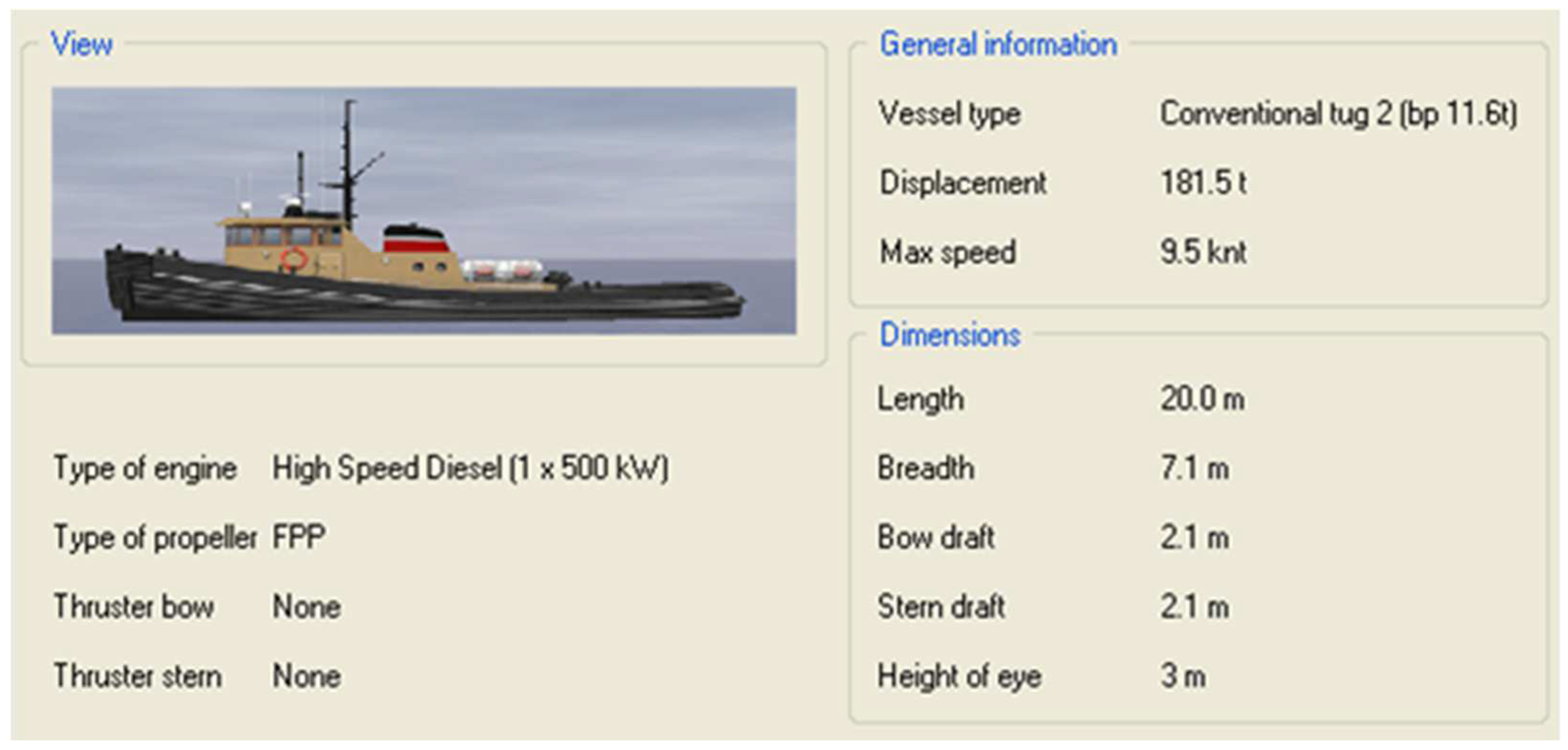
The above assumptions were compared with the parameters of all models of the vessels and barges available on the test bench [25]. From the available database, a representative model of the tugboat “Conventional tug 2” with the characteristics presented in Figure 4 was selected [26]. The parameters of the tugboat after the connection to the barge are presented in the Figure 5 and Table 1.
The above model, combined “inflexibly” with a barge, which has length L = 55 m and breadth B = 7 m and with moulded draught T = 2 m, made it possible to use a pushed set with the following maximum parameters: Lmax. = 75 m, Bmax. = 7.1 m, and Tmax. = 2.1 m (Table 1).
The realization of the simulation consisted of performing the unit’s manoeuvres on the planned routes. This type of simulated manoeuvres is used for an initial check of the dimensions and design of a given waterway. They were conducted on the basis of the automatic control system, which can be used and included in fast-time simulations during the initial planning for the general placement of aids to navigation in waterways and in the approach and access to ports, especially when evaluating several proposed designs and layouts. The helmsman is replaced by an advanced autopilot that reacts with a determined response to deviations from the track. As this autopilot is fed with perfect knowledge of the state of the vessel and the environmental influences, it is not certain that a human operator will be able to produce the same results. A subsequent full-mission simulator in combination with real-time simulations meets this requirement [7].
4. Results
The simulation attempts for the first and second tasks under the assumed conditions succeeded. According to the research foundations, during the simulation attempts, neither the contact of the model with the bottom nor the contact of the vessel with the hydrotechnical structure was recorded, and moreover, the model remained within the determined boundaries along the entire length of the planned route (Figure 6 and Figure 7).
The results of the simulation tests are consistent with those carried out on 6–8 April 2021 during the Pilot Container Cruise Along Lower Vistula—Wisła Cargo 2021 [27]. Average speeds on the main sections of waterways were compared when the unit’s manoeuvres were performed on the planned routes, and only insignificant differences were observed between the pilot cruise and simulation trails. The comparison of the simulation and pilot cruise results are presented in the Table 2.
The cruise was conducted as a part of the EMMA Extension (INTERREG Baltic Sea Region program). Its aim was to check the possibility of transport by the Vistula waterway as an alternative to road or rail transport.
The prerequisite for shipping on the waters of Gdansk Bay and the Martwa Wisła by container barges is to define the conditions and to develop the requirements and rules according to which it could be carried out. The synthesis of the results from the successfully conducted initial simulation attempts and from the pilot cruise enables to undertake further research to prepare scenarios for appropriate simulation tests. Such studies are used to check the navigational markers signalling the course of the route, the capacity of the waterway, and the location of difficult and burdensome sections for navigation on this stretch of the Vistula.
5. Discussion
In order to check the possibility of using inland navigation for servicing Tri-City ports, a pilot container cruise from Gdansk to Warsaw was made in 2017 to promote the potentiality of inland navigation. The route was 440 km and was traversed with the use of a barge with 49.90 m × 9.03 m dimensions and a pusher 22.40 m length, carrying 20 containers. On the entire route, the set overcame three locks: Przegalina, Włocławek, and Czersko Polskie. It travelled from 20 to 80 km daily although its capabilities exceed 100 km [27]. The barge left Gdansk on 19 April 2017, and it had eight stops during its cruise. These stops were in Tczew, Grudziądz, Bydgoszcz, Solec Kujawski, Toruń, Włocławek, Płock, and Nowy Dwór Mazowiecki. On 27 April 2019, it finally reached Warsaw on the Vistula Boulevard. The second important pilot passage took place on 6 April 2021, the aim of which was to transport six containers with a total weight of 150 tons. The transport was held on the route Port of Gdansk—Toruń. The barge reached Chełmno on 8 April, where it was reloaded and sailed downstream to the seaport of Gdansk. The return passage ended on 9 April. Carrying out such projects has made it possible to indicate many advantages of inland navigation, and as the most important feature, it has revealed that even currently, it can significantly facilitate the export of cargo from the Tri-City seaports into the inland areas of Poland.
In accordance with the simulation studies and referring to the verification on the field, it can be seen that inland navigation may become a real alternative to road transport in the Tri-City area.
As a conclusion, it can be stated that the navigation on the studied stretches is possible. On this level, performed simulations can be used for an overall evaluation of aids to navigation placement, routeing, and needs for modifications in present conditions in combination with review of recorded tracks. Recorded tracks provide a very important basis for the evaluation of present conditions and are today already used as a decision-making tool for planning the placement and modification of aids to navigation [25].
In addition to relieving road traffic, it will also reduce the emission of harmful substances to the environment and decrease transport costs, and moreover, it will solve the problem of transporting oversize loads [28]. However, the greatest benefit will be the development of seaports and the possibility of increasing transhipments [29,30,31]. If it is not enough, their competitiveness in the Baltic Sea area will also increase, and the interest in the Tri-City seaports, as places with efficiently prospering facilities, will be aroused.
6. Summary
The aim of the study was to determine the possibility of increasing the cargo capacity of the Port of Gdansk and the Port of Gdynia in view of the vision of cargo transported by inland waterway. The article presents the results of an operational analysis from the navigation and manoeuvring simulator, where scenarios in which the barge from the Tri-City seaports reaches Zajączkowo Tczewskie were accomplished. The simulation study showed the potential possibility of the successful execution of the project. Therefore, the authors assume that the concept of launching inland navigation is justified and will relieve truck traffic in the Tri-City area. It is very important for the protection of the natural environment. Certainly, the increase in inland transport will reduce reliance on other modes of transport, which will bring tangible results for the whole society.
Author Contributions
Conceptualization, A.K. and K.F.; methodology, K.F.; formal analysis, A.K.; resources, M.W.; data curation, M.W.; writing—original draft preparation, K.F.; writing—review and editing, T.N.; visualization, K.F.; supervision, T.N.; project administration, T.N.; funding acquisition, T.N. All authors have read and agreed to the published version of the manuscript.
Funding
This study was funded by the Gdynia Maritime University, the research project: WN/2022/PZ/07.
Conflicts of Interest
The authors declare no conflict of interest.
References
- Myszka, A.; Kaizer, A. Analysis of the Vessels’ Service Time in the Port of Gdańsk, Based on the Time Registration of Ships Entries and Departures, as a Proposition of Multi-Aspect Method of Port Monitoring. TransNav Int. J. Mar. Navig. Saf. Sea Transp. 2020, 14, 465–468. [Google Scholar] [CrossRef]
- Kosiek, J.; Kaizer, A.; Salomon, A.; Sacharko, A. Analysis of Modern Port Technologies Based on Literature Review. TransNav Int. J. Mar. Navig. Saf. Sea Transp. 2021, 15, 667–674. [Google Scholar] [CrossRef]
- Ziemska, M.; Plodzik, E.; Falkowska, M. Comparative Analysis of Ports Practices and Activities in the Tri-City and China. TransNav Int. J. Mar. Navig. Saf. Sea Transp. 2019, 13, 641–646. [Google Scholar] [CrossRef]
- Google Maps. Available online: https://Www.Google.Pl/Maps/@54.6856423,17.1403752,7.13z?Hl=en (accessed on 13 May 2022).
- Nasri, M.I.; Bektaş, T.; Laporte, G. Route and Speed Optimization for Autonomous Trucks. Comput. Oper. Res. 2018, 100, 89–101. [Google Scholar] [CrossRef]
- Larsson, J.; Keskin, M.F.; Peng, B.; Kulcsár, B.; Wymeersch, H. Pro-Social Control of Connected Automated Vehicles in Mixed-Autonomy Multi-Lane Highway Traffic. Commun. Transp. Res. 2021, 1, 100019. [Google Scholar] [CrossRef]
- IALA. IALA Guideline-1058 the Use of Simulation as a Tool for Waterway Design and AtoN Planning, 2nd ed. 2011. Available online: https://www.iala-aism.org/product/g1058/?download=true (accessed on 21 October 2021).
- Skupien, E.; Tubis, A.; Rydlewski, M. The Analysis of Offenses in Inland Navigation in Poland 2013-2017. TransNav Int. J. Mar. Navig. Saf. Sea Transp. 2019, 13, 151–156. [Google Scholar] [CrossRef]
- Kaizer, A.; Neumann, T. The Model of Support for the Decision-Making Process, While Organizing Dredging Works in the Ports. Energies 2021, 14, 2706. [Google Scholar] [CrossRef]
- Soliwoda, J.; Kaizer, A.; Neumann, T. Possibility of Capsizing of a Dredger during Towing. Water 2021, 13, 3027. [Google Scholar] [CrossRef]
- Wojewódzka-Król, K.; Rolbiecki, R. Społeczno-Ekonomiczne Skutki Zagospodarowania Dolnej Wisły; Energa SA: Gdansk, Poland, 2017; ISBN 978-83-945413-0-9. [Google Scholar]
- Wojewódzka-Król, K.; Rolbiecki, R. Rozwój transportu wodnego śródlądowego na zapleczu portów morskich—ważne i aktualne wyzwanie. Probl. Transp. I Logistyki 2017, 37, 285–295. [Google Scholar] [CrossRef]
- Fajczak-Kowalska, A. Analiza Przewozów Ładunków Według Gałęzi Transportu W Latach 1995–2018; Wydawnictwo Politechniki Łódzkiej: Łódź, Poland, 2021; ISBN 978-83-66741-21-8. [Google Scholar]
- Rolbiecki, R.; Gus-Puszczewicz, A. Droga wodna Dolna Wisła jako czynnik wzmacniający potencjał transportowy na zapleczu portu morskiego w Gdańsku. Pr. Nauk. Uniw. Ekon. We Wrocławiu 2021, 65, 144–156. [Google Scholar] [CrossRef]
- Lee, B.K.; Low, J.M.W. Resource Capacity Requirement for Multi-Terminal Cooperation in Container Ports. Appl. Sci. 2021, 11, 9156. [Google Scholar] [CrossRef]
- Kuznetsov, A.; Oja, H.; Semenov, A.D. Analytical Assessment of Stochastic Spread of Demand for the Port Storage Capacity. TransNav Int. J. Mar. Navig. Saf. Sea Transp. 2020, 14, 841–844. [Google Scholar] [CrossRef]
- Bazaluk, O.; Havrysh, V.; Nitsenko, V. Energy Efficiency of Inland Waterways Transport for Agriculture: The Ukraine Case Study. Appl. Sci. 2021, 11, 8937. [Google Scholar] [CrossRef]
- Obwieszczenie Ministra Infrastruktury z Dnia 28 Marca 2018 r. w Sprawie Ogłoszenia Jednolitego Tekstu Rozporządzenia Ministra Transportu, Budownictwa i Gospodarki Morskiej w Sprawie Planu Zrównoważonego Rozwoju Publicznego Transportu Zbiorowego w Zakresie Sieci Komunikacyjnej w Międzywojewódzkich i Międzynarodowych Przewozach Pasażerskich w Transporcie Kolejowym. Available online: http://isap.sejm.gov.pl/isap.nsf/DocDetails.xsp?id=WDU20180000874 (accessed on 21 October 2021).
- Najwyższa Izba Kontroli Informacja o Wynikach Kontroli Infrastruktura Dostępowa Do Portów Morskich. Available online: www.nik.gov.pl/plik/id,17942,vp,20530.pdf (accessed on 21 October 2021).
- White Paper Roadmap to a Single European Transport Area—Towards a Competitive and Resource Efficient Transport System EUR-Lex-52011DC0144-EN-EUR-Lex. Available online: https://eur-lex.europa.eu/legal-content/EN/TXT/?uri=CELEX%3A52011DC0144 (accessed on 21 October 2021).
- Port of Gdańsk Authority SA. Available online: https://www.port.gdynia.pl/pl/o-porcie/dane-portu (accessed on 21 October 2021).
- The European Parliament and The Council of the European Union. Directive (EU) 2016/1629 of the European Parliament and of the Council of 14 September 2016 Laying down Technical Requirements for Inland Waterway Vessels, Amending Directive 2009/100/EC and Repealing Directive 2006/87/EC. Off. J. Eur. Union 2016, 252, 119–137. [Google Scholar]
- Transas Marine Ltd. Navi-Trainer 5000; Transas Marine Ltd.: Helsinki, Finland, 2020. [Google Scholar]
- Kulczyk, J.; Winter, J. Śródlądowy Transport Wodny; Oficyna Wydawnicza Politechniki Wrocławskiej: Wrocław, Poland, 2003; ISBN 978-3-7085-7200-0. [Google Scholar]
- Transas MIP Ltd. Transas Navigational Simulators. #90005221; Transas Ltd.: Helsinki, Finland, 2020. [Google Scholar]
- Transas Marine Ltd. Ships Data: Pilot Card and Wheelhouse Poster; Transas Marine Ltd.: Helsinki, Finland, 2020. [Google Scholar]
- Pilotażowy Rejs Kontenerowy Dolną Wisła—Wisła Cargo 2021. Available online: http://wislacargo.kujawsko-pomorskie.pl/ (accessed on 21 October 2021).
- Fraselle, J.; Limbourg, S.L.; Vidal, L. Cost and Environmental Impacts of a Mixed Fleet of Vehicles. Sustainability 2021, 13, 9413. [Google Scholar] [CrossRef]
- Xie, W.; Zhuge, S.; Wu, Y.; Xiao, D. Simulation-Based Operational Evaluation of a Single-Berth Multipurpose Seaport with Wharf Space Restriction. J. Mar. Sci. Eng. 2021, 9, 883. [Google Scholar] [CrossRef]
- Lisaj, A. Implementation of E-Navigation Strategies for RIS Centres Supporting Inland Navigation. TransNav Int. J. Mar. Navig. Saf. Sea Transp. 2019, 13, 145–149. [Google Scholar] [CrossRef]
- Feng, M.; Cheng, Y. Solving Truck-Cargo Matching for Drop-and-Pull Transport with Genetic Algorithm Based on Demand-Capacity Fitness. Alex. Eng. J. 2021, 60, 61–72. [Google Scholar] [CrossRef]
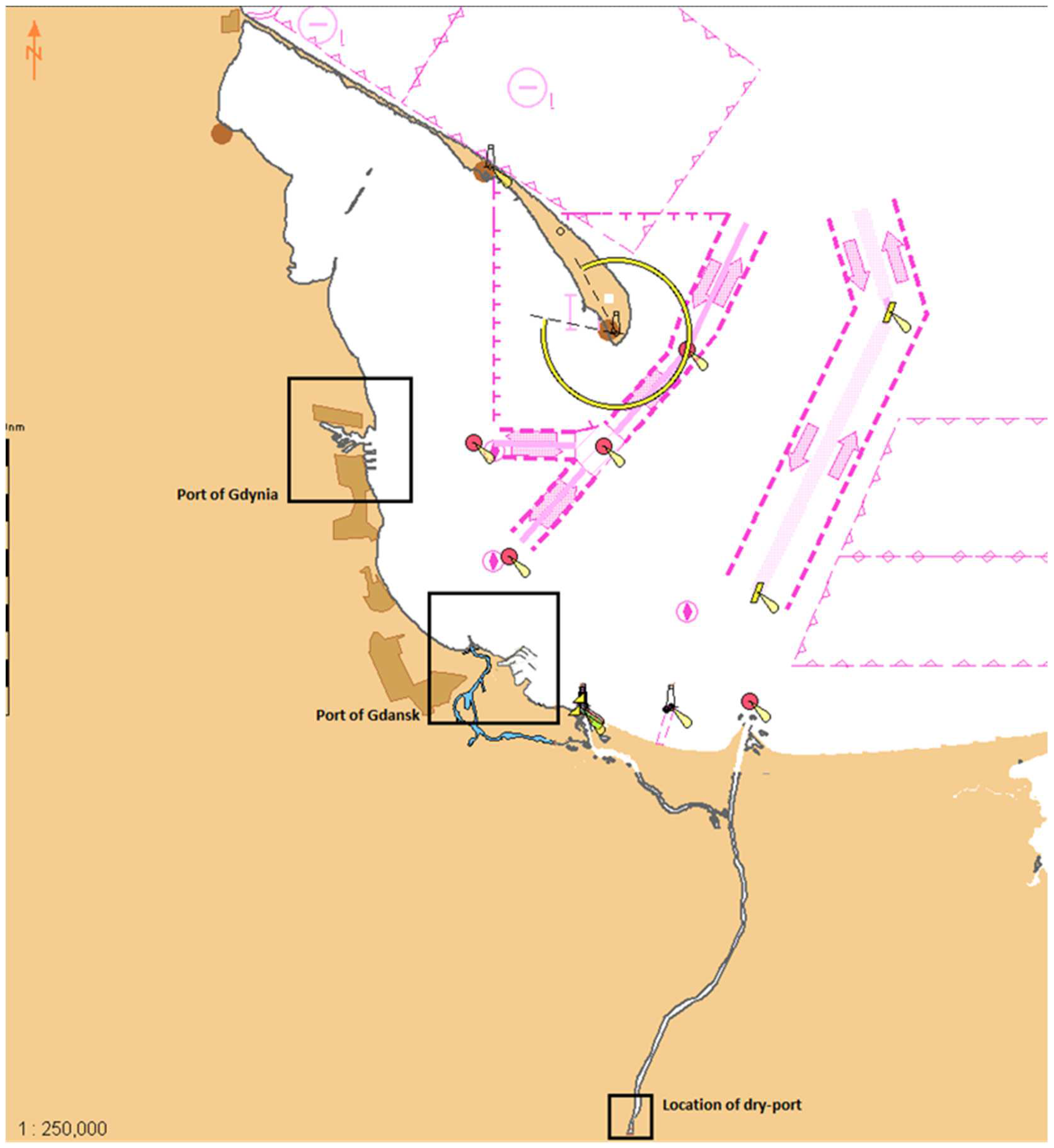
Figure 1.
Gulf of Gdansk in the southern Baltic Sea with marked ports in Gdańsk, Gdynia, and a dry port in Zajączkowo Tczewskie. Source: ECDIS NaviSailor 4000.
Figure 1.
Gulf of Gdansk in the southern Baltic Sea with marked ports in Gdańsk, Gdynia, and a dry port in Zajączkowo Tczewskie. Source: ECDIS NaviSailor 4000.

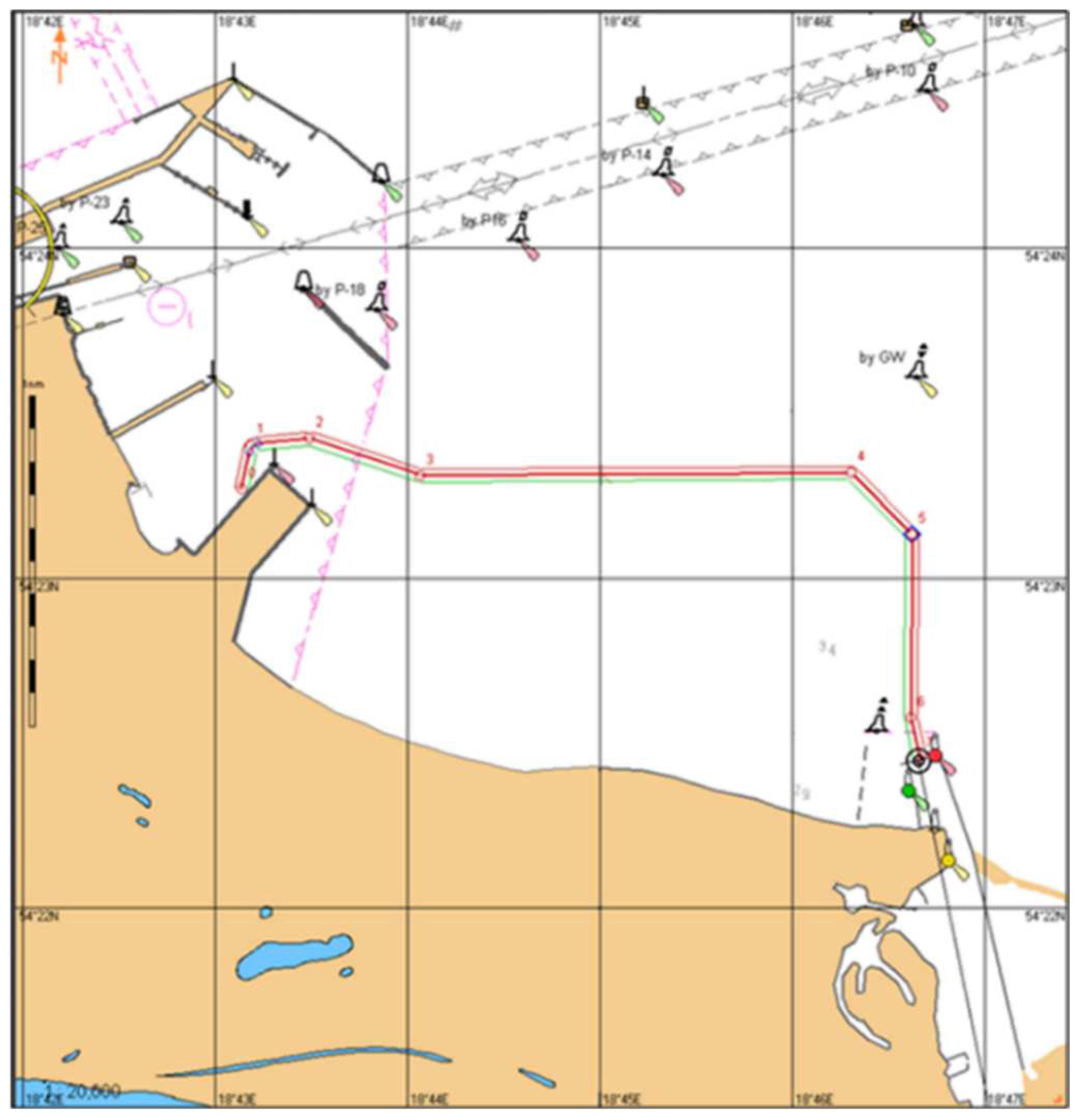
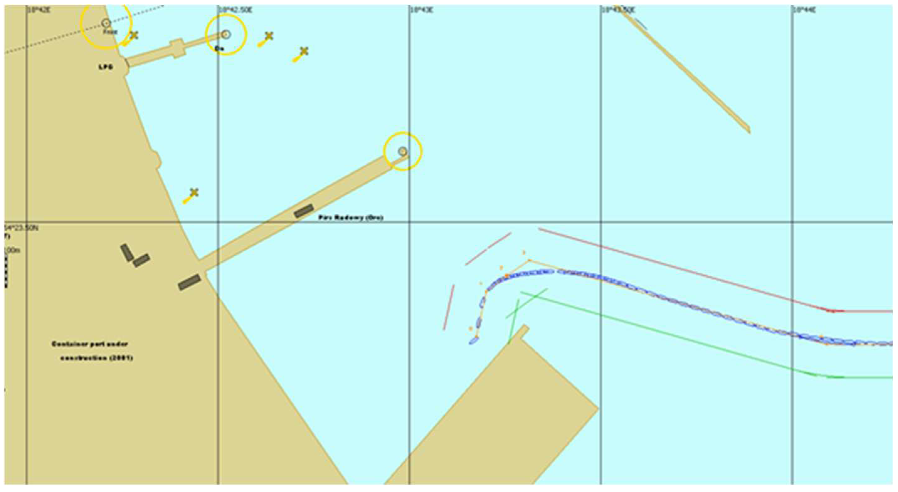
Figure 2.
The route planned on the stretch from the first task (from the quay of the container terminal in Gdansk to the mouth of the Martwa Wisła). Source: ECDIS NaviSailor 4000.
Figure 2.
The route planned on the stretch from the first task (from the quay of the container terminal in Gdansk to the mouth of the Martwa Wisła). Source: ECDIS NaviSailor 4000.

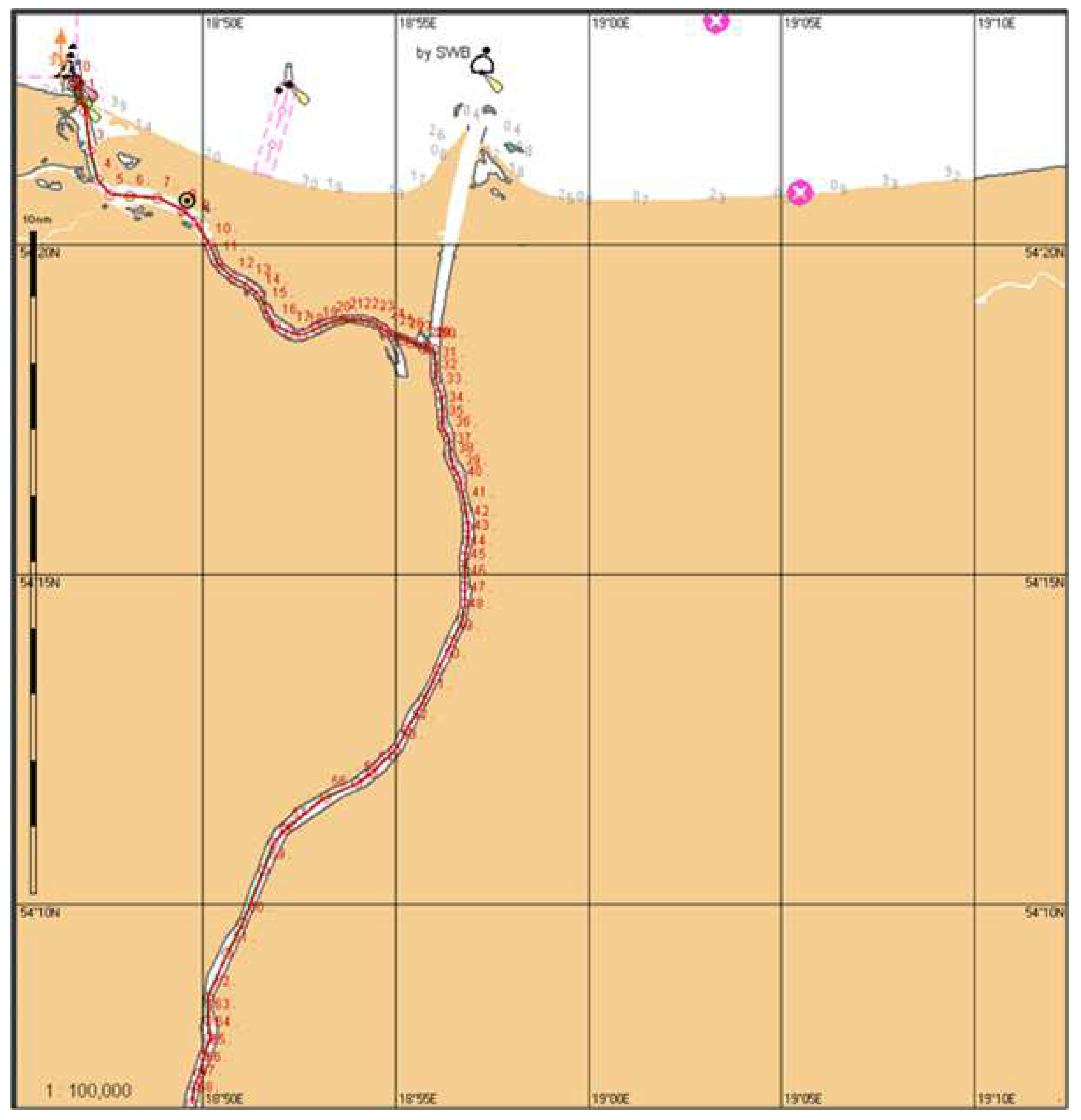
Figure 3.
The route planned on the stretch from the second task (from the mouth of the Martwa Wisła to the dry port in Zajączkowo Tczewskie). Source: ECDIS NaviSailor 4000.
Figure 3.
The route planned on the stretch from the second task (from the mouth of the Martwa Wisła to the dry port in Zajączkowo Tczewskie). Source: ECDIS NaviSailor 4000.

Figure 4.
Characteristics of the “Conventional tug 2” model. Source: Navi-Trainer Professional 5000.
Figure 4.
Characteristics of the “Conventional tug 2” model. Source: Navi-Trainer Professional 5000.

Figure 5.
Outline of the model combined with the barge.

Figure 6.
The trajectory recorded during the conduction of simulation attempt through the planned route from the first task. Source: Navi-Trainer Professional 5000.
Figure 6.
The trajectory recorded during the conduction of simulation attempt through the planned route from the first task. Source: Navi-Trainer Professional 5000.

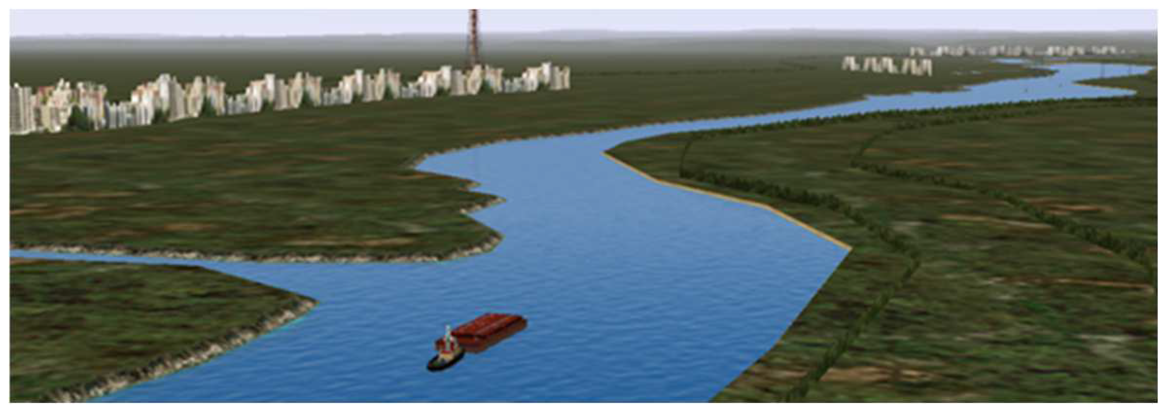
Figure 7.
A pusher and a barge on the assigned route from the second task during the simulation attempt. Source: Navi-Trainer Professional 5000.
Figure 7.
A pusher and a barge on the assigned route from the second task during the simulation attempt. Source: Navi-Trainer Professional 5000.


Table 1.
Selected parameters of the model combined with the barge.
| Model | Total Length (Lmax) | Maximum Breadth (Bmax) | Maximum Moulded Draught (Tmax) | Machine Power | Propulsion | Steering Gear |
|---|---|---|---|---|---|---|
| Conventional tug 2 together with the barge | 75 m | 7.1 m | 2.1 m | 500 kW | 1 × FPP | 1 × balanced rudder (max. 35) |
Table 2.
The comparison of the simulation and pilot cruise results.
| Location | Distance [Nm] | Pilot Cruise Time/Time Taken [hh:mm] | Simulation Time/Time Taken [hh:mm] | Average Speed (Pilot Cruise) [knt] | Average Speed (Simulation) [knt] |
|---|---|---|---|---|---|
| Departure from the Gdańsk (Szczecinskie berth) | - | 12:00/00:00 | 12:00/00:00 | - | - |
| Passing the lock (Przegalina) | 11.7 Nm | 15:00/03:00 | 14:48/02:48 | 3.90 | 4.18 |
| Arrival (area in the vicinity of port in Zajączkowo Tczewskie) | 14.3 Nm | 18:00/03:00 | 18:06/3:18 | 4.77 | 4.33 |
| Total | 26.0 Nm | 18:00/03:00 | 06:06 | 4.33 | 4.26 |
Publisher’s Note: MDPI stays neutral with regard to jurisdictional claims in published maps and institutional affiliations. |
© 2022 by the authors. Licensee MDPI, Basel, Switzerland. This article is an open access article distributed under the terms and conditions of the Creative Commons Attribution (CC BY) license (https://creativecommons.org/licenses/by/4.0/).
Share and Cite
MDPI and ACS Style
Kaizer, A.; Winiarska, M.; Formela, K.; Neumann, T. Inland Navigation as an Opportunity to Increase the Cargo Capacity of the Tri-City Seaports. Water 2022, 14, 2482. https://doi.org/10.3390/w14162482
AMA Style
Kaizer A, Winiarska M, Formela K, Neumann T. Inland Navigation as an Opportunity to Increase the Cargo Capacity of the Tri-City Seaports. Water. 2022; 14(16):2482. https://doi.org/10.3390/w14162482
Chicago/Turabian StyleKaizer, Adam, Magdalena Winiarska, Kamil Formela, and Tomasz Neumann. 2022. "Inland Navigation as an Opportunity to Increase the Cargo Capacity of the Tri-City Seaports" Water 14, no. 16: 2482. https://doi.org/10.3390/w14162482
Note that from the first issue of 2016, this journal uses article numbers instead of page numbers. See further details here.