
Strategic Design and Delivery of Integrated Catchment Restoration Monitoring: Emerging Lessons from a 12-Year Study in the UK

 , , ,
, , , 
Abstract
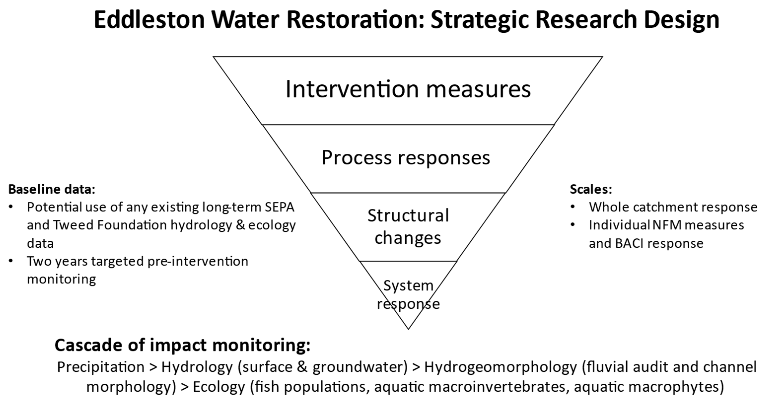
:1. Introduction
- (1)
- The original monitoring strategy—scientific approach, project management and governance;
- (2)
- How and to what extent the individual elements of the monitoring network combine to meets the strategic aims—monitoring programme design;
- (3)
- Changes made in monitoring and implementation—monitoring programme delivery.
2. Materials and Methods
2.1. The Eddleston Water Project
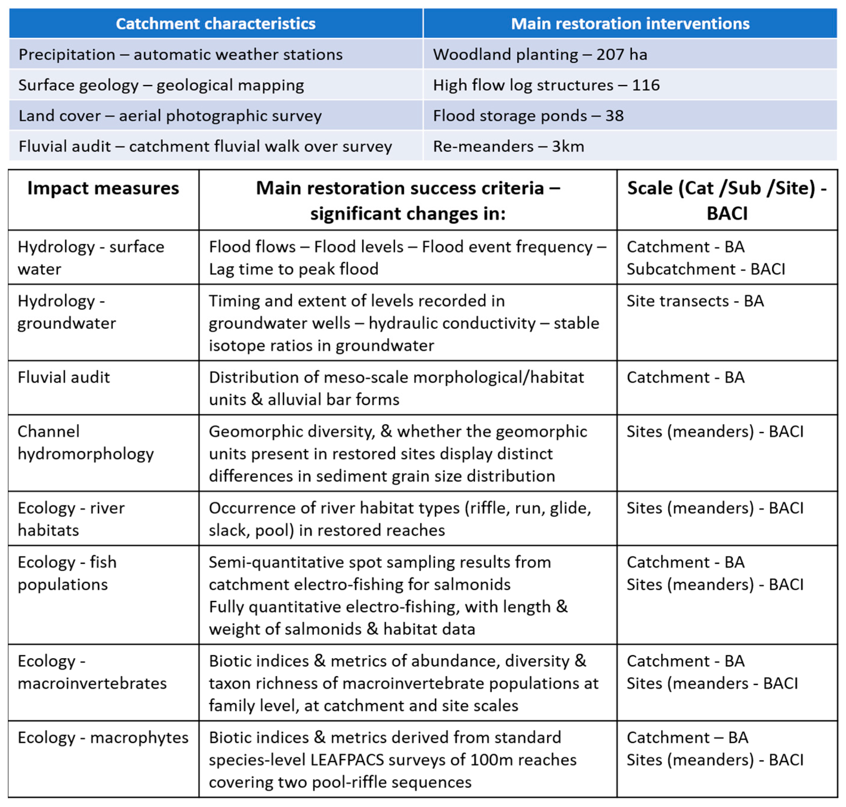
- 207 hectares of woodland planting, with over 330,000 native trees;
- 116 high-flow log structures, positioned on upper tributary streams;
- 36 flow-attenuation ponds located in the headwaters and 2 larger ones on the lower floodplain;
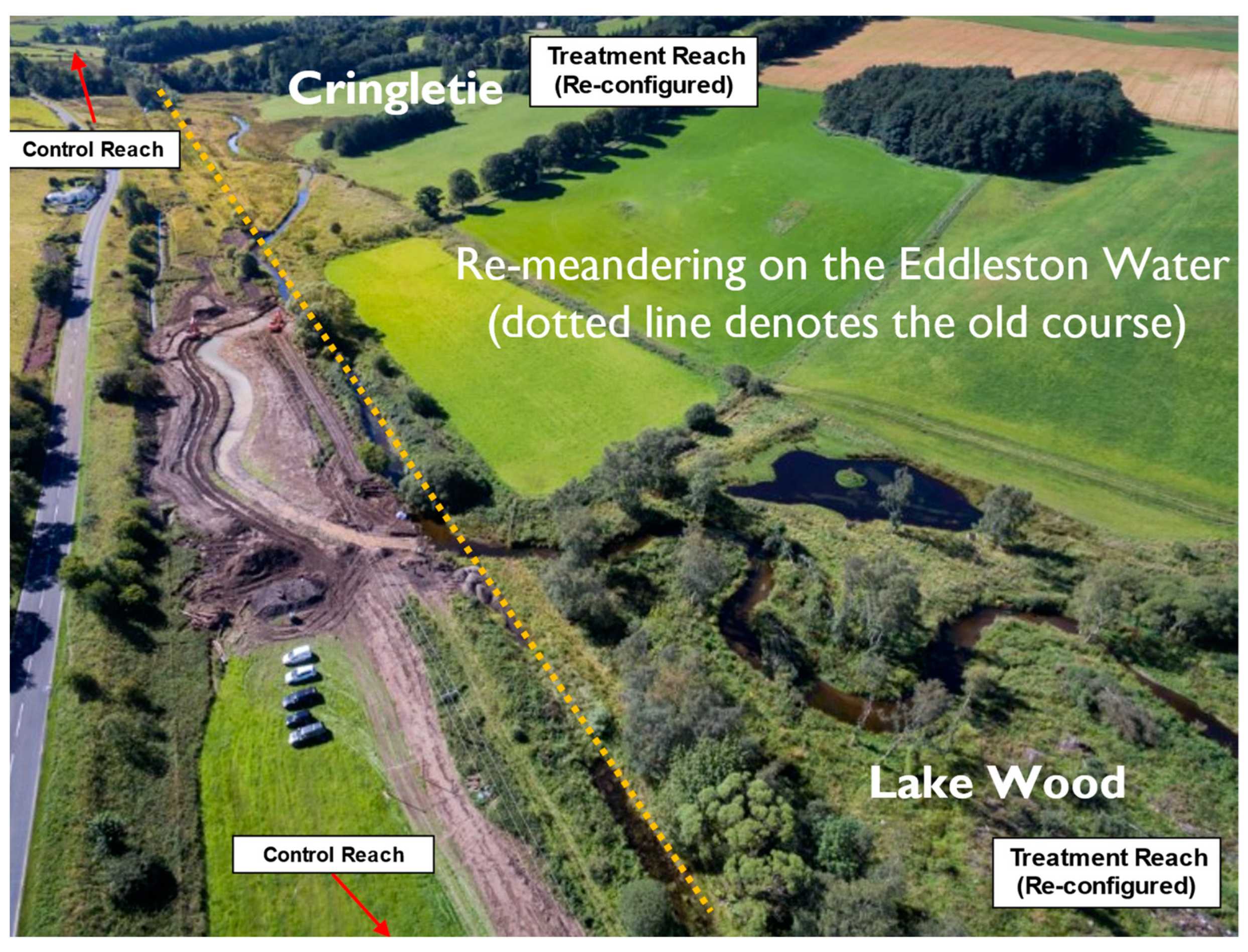
- 3.0 km of previously straightened river channel remeandered, with adjacent flood banks removed.
- To reduce the risk of flooding to downstream communities through the utilisation of NFM measures;
- To improve habitats for wildlife and raise the ‘ecological status’ of the river (as originally defined in the EU Water Framework Directive (WFD);
- To work with landowners and farmers to maximise the benefits of the work, whilst sustaining their businesses and farming practices.
- (a)
- Develop a comprehensive hydrometry network to form the underpinning hydrological dataset for the whole study;
- (b)
- Identify locations for monitoring associated changes in groundwater, fluvial hydrogeomorphology and ecology, with reference to existing and proposed monitoring programmes at both catchment and individual reach scales;
- (c)
- Establish protocols on methodologies, data capture, quality control and data archiving.
2.2. Methods
- Surface water hydrology;
- Groundwater studies;
- Catchment fluvial audit;
- Channel fluvial geomorphology;
- Fish populations;
- Aquatic macroinvertebrates;
- Aquatic macrophytes.
3. Results
3.1. The Monitoring Strategy: Scientific Approach, Project Management and Governance
3.2. How the Individual Monitoring Networks Meet the Strategic Aims
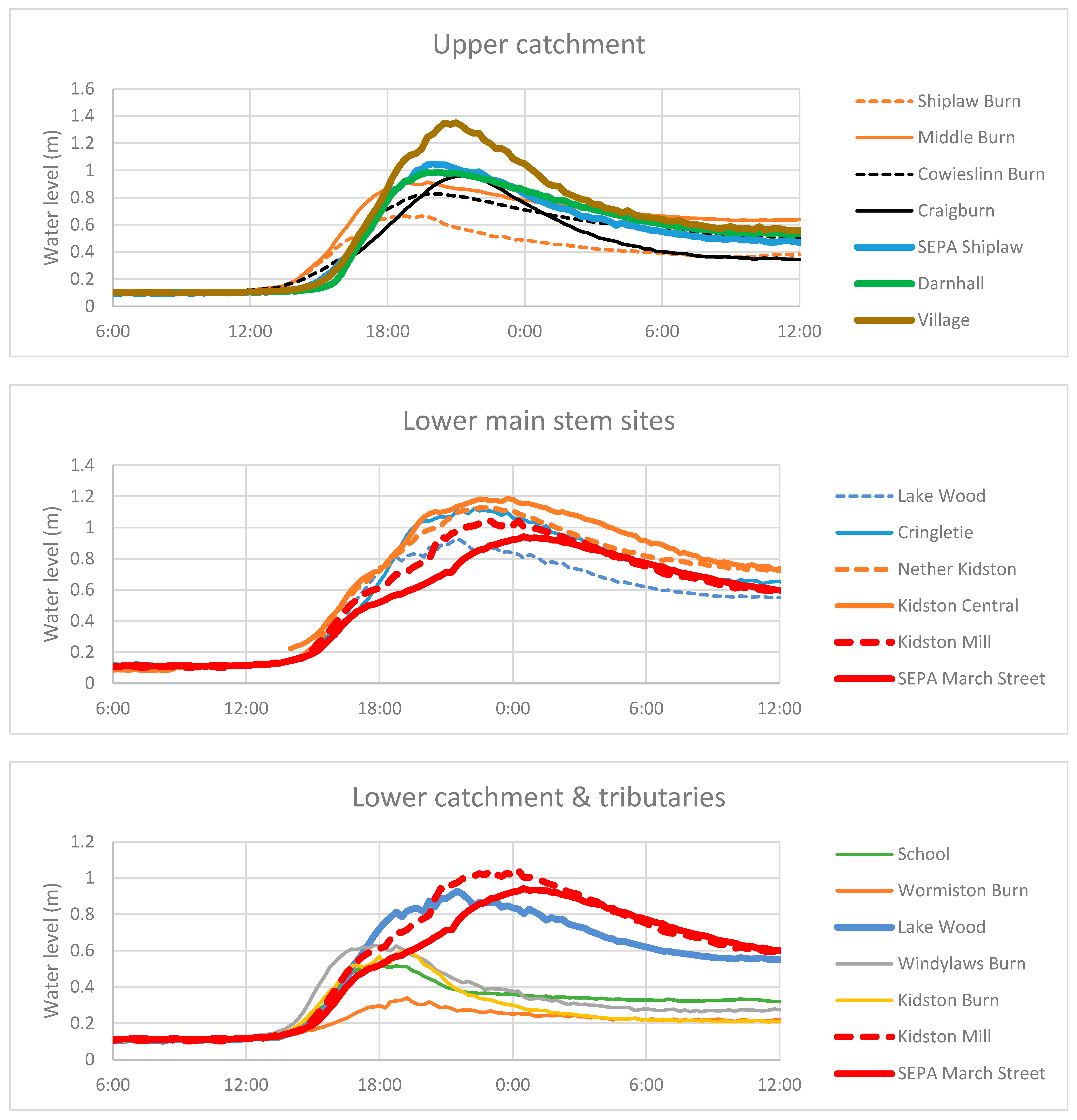
3.2.1. Surface Water Fluxes
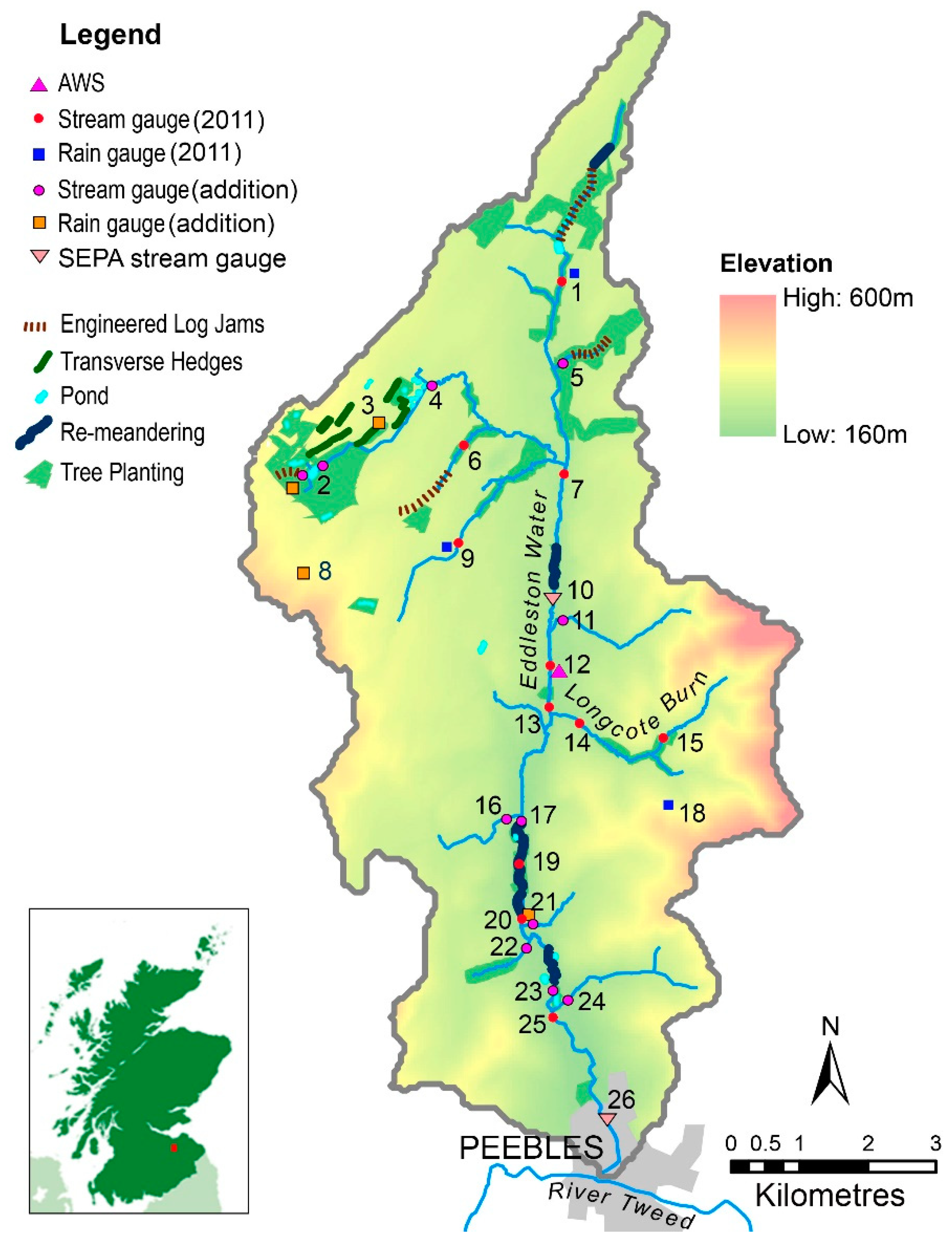
- An upstream site (Shiplaw) providing water level and discharge data from 2002, as well as continuation precipitation records from 1990;
- A downstream site at the catchment foot (Peebles) providing water levels from 2009.
- To meet project aims, these were integrated with new elements including:
- An automatic weather station (for determination of a catchment water balance);
- Recording and storage rain gauges at eight additional sites (to characterise spatial variation in precipitation across the catchment);
- 12 additional streamflow-gauging stations (to measure the contributions of tributaries to the main stem and changes in discharge along the main stem downstream), plus 12 additional water level gauges subsequently installed to fill the gaps;
- 11 water gauges located on ponds to specifically monitor their response to runoff.
3.2.2. Groundwater Monitoring
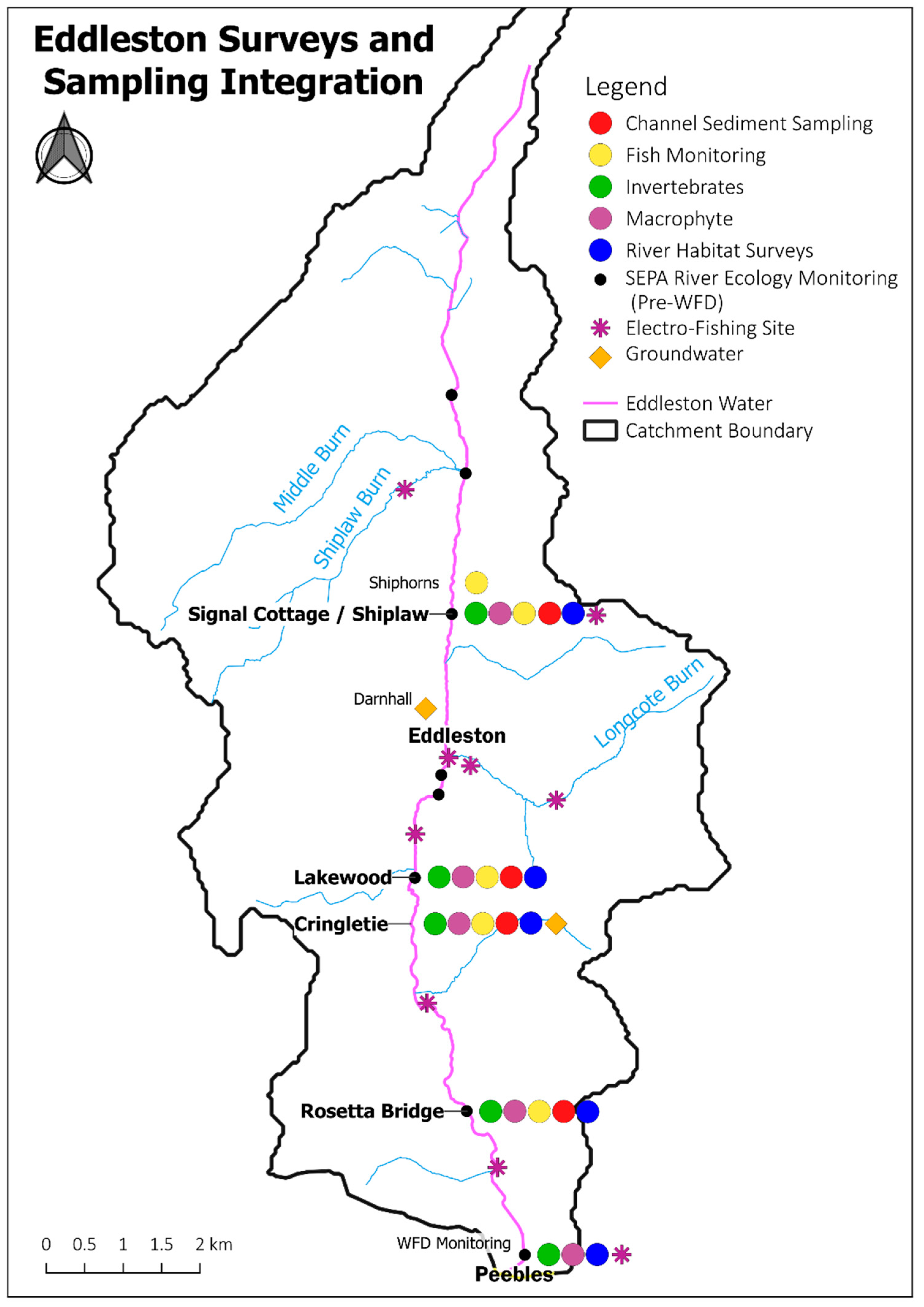
3.2.3. Ecological Monitoring
3.2.4. Water Quality
3.2.5. Sediment Fluxes
3.2.6. Catchment Fluvial Audit, LiDAR and Channel Fluvial Geomorphology
3.2.7. Other Monitoring and Modelling Undertaken in the Eddleston as a Research Platform
3.3. Changes in Monitoring Design and Implementation
3.3.1. Changes in Choices of Parameters
3.3.2. Changes in Methodologies (Including Timing and Frequencies)
3.3.3. Changes in Locations
4. Discussion
4.1. Scientific Approach, Project Management and Governance
4.2. Monitoring Programme Design
4.3. Monitoring Programme Delivery
5. Conclusions
- Trying to monitor integrated catchment restoration across disciplines at a landscape scale requires a mature form of governance and flexible project management. On the one hand, this needs to set the direction and bounds of implementation and research monitoring, but on the other, it needs to look to attract, integrate and enable individual areas of assessment and monitoring, recognising their respective challenges and opportunities.
- Good governance and project management need to both encourage new initiatives and cooperative working and also ensure ongoing research is not compromised. In a long-term empirical study where landowner consent to monitoring is entirely voluntary, the consequences of alienating key landowners and co-workers could be disastrous for research continuity.
- A publicly funded research platform such as the Eddleston, which has the advantage of providing an ongoing field-based experiment, is open to increasing pressures from competing external research interests. Integrating these with the strategic aims and ongoing research programmes remains a challenge and may not always be possible.
- With all aspects of catchment restoration ecology ultimately being linked back to hydrological and hydromorphological change, the importance of developing a process-based impact assessment framework, underpinned by a dense and strategically located hydrological monitoring network, is paramount, as is co-locating monitoring of different elements and disciplines.
- The production of a restoration scoping study to characterise catchment hydrology and identify key habitats can greatly assist in focussing on priority drivers and identifying monitoring methods and sites for assessing change. This is especially relevant where empirical data are used as the basis for restoration monitoring, holding both for natural sub-catchment comparisons and experimental BACI designs where null hypotheses can be tested.
- Working on larger scales temporally and spatially brings challenges in terms of increasing complexity and ‘noise’ from external drivers of environmental change unrelated to restoration per se. Whilst a BACI design may be able to mitigate these pressures, even control sites may show significant change over time, and their location within the same or different study catchment needs to be assessed. If, as here, controls are located within the same catchment, future studies might wish to extend the monitoring for several 100 m downstream of restoration.
- The importance of capturing the full range of baseline and natural events is well demonstrated, with pre-implementation data needing to cover the full range of habitats, species and events of different size and frequency.
- Co-location of monitoring sites will not be enough on its own to distinguish the responses at a systems level, so there is a need to understand the linkages and process changes at the geomorphological unit scale, at the reach scale and at the whole-systems level of the catchment.
- Assessment of restoration success needs to include the often overlooked three-dimensional nature of water flow through the catchment surface and groundwater environments in terms of both ecological response and hydraulic connectivity.
- For effective quality assurance, not only is repeating the use of recognised monitoring methodologies and associated QA important in enabling comparisons and reducing uncertainty, so is using the same surveyors and locations over extended time periods
- However, gains from continuing with historic measures may divert from quantitative and novel approaches that could potentially yield more focussed results. The emergence of new monitoring techniques should be kept under review and, as with new research questions, consideration of their integration into current monitoring should be prioritised.
- Ecological responses to hydromorphological perturbations may still be occurring many years later, which highlights the need for consistent long-term observations to cover the complete trajectory of change due to restoration measures, something few studies have either time or resources to undertake.
Author Contributions
Funding
Institutional Review Board Statement
Informed Consent Statement
Data Availability Statement
Acknowledgments
Conflicts of Interest
References
- United Nations Decade on Restoration. Available online: https://documents-dds-ny.un.org/doc/UNDOC/GEN/N19/060/16/PDF/N1906016.pdf?OpenElement (accessed on 25 May 2022).
- World Wildlife Fund. Bending the Curve of Biodiversity Loss: A Deep Dive into Freshwater. In Living Planet Report 2020; Almond, R.E.A., Grooten, M., Petersen, T., Eds.; WWF: Gland, Switzerland; Available online: https://wwfin.awsassets.panda.org/downloads/lpr_2020___deep_dive_into_freshwater.pdf (accessed on 25 May 2022).
- Department for Environment, Food & Rural Affairs. Nature Recovery Network. Policy paper. April 2022. Available online: https://www.gov.uk/government/publications/nature-recovery-network/nature-recovery-network#:~:text=Defra%20and%20Natural%20England%20are,enhancing%20England%27s%20wildlife%2Drich%20places (accessed on 25 May 2022).
- UN Convention on Biological Diversity & Scottish Government. Edinburgh Declaration on Post-2020 Global Biodiversity Framework. 2021. Available online: https://www.gov.scot/publications/edinburgh-declaration-on-post-2020-biodiversity-framework/pages/current-signatories/ (accessed on 25 May 2022).
- International Union for the Conservation of Nature. IUCN Global Standard for Nature-Based Solutions, 1st ed.; IUCN: Gland, Switzerland, 2020; Available online: https://portals.iucn.org/library/sites/library/files/documents/2020-020-En.pdf (accessed on 25 May 2022).
- Stafford, R.; Chamberlain, B.; Clavey, L.; Gillingham, P.K.; McKain, S.; Morecroft, M.D.; Morrison-Bell, C.; Watts, O. (Eds.) Nature-Based Solutions for Climate Change in the UK: A Report by the British Ecological Society. BES: London, UK, 2021. Available online: www.britishecologicalsociety.org/nature-based-solutions (accessed on 25 May 2022).
- Spray, C.J.; Maltby, E.; Clavey, L. Freshwater Systems. Chapter 6. In Nature-Based Solutions for Climate Change in the UK: A Report by the British Ecological Society; Stafford, R., Chamberlain, B., Clavey, L., Gillingham, P.K., McKain, S., Morecroft, M.D., Morrison-Bell, C., Watts, O., Eds.; BES: London, UK, 2021; pp. 89–106. [Google Scholar]
- Palmer, M.A.; Bernhardt, E.S.; Allan, J.D.; Lake, P.S.; Alexander, G.; Brooks, S.; Carr, J.; Clayton, S.; Dahm, C.N.; Follstad-Shah, J.; et al. Standards for ecologically successful river restoration. J. Appl. Ecol. 2005, 42, 208–217. [Google Scholar] [CrossRef]
- Beechie, T.J.; Sear, D.A.; Olden, J.D.; Pess, G.R.; Buffington, J.M.; Moir, H.; Roni, P.; Pollock, M.M. Process-based Principles for Restoring River Ecosystems. BioScience 2010, 60, 209–222. [Google Scholar] [CrossRef] [Green Version]
- England, J.; Naura, M.; Mant, J.; Skinner, K. Seeking river restoration appraisal best practice: Supporting wider national and international environmental goals. Water Environ. J. 2020, 34, 1003–1011. [Google Scholar] [CrossRef]
- Dadson, S.; Hall, J.; Murgatroyd, A.; Acreman, M.; Bates, P.; Beven, K.; Wilby, R. A restatement of the natural science evidence concerning catchment-based ‘natural’ flood management in the UK. Proc. R. Soc. A 2017, 473, 2199. [Google Scholar] [CrossRef] [PubMed] [Green Version]
- The Parliamentary Office of Science and Technology. POSTNOTE 623 Natural Mitigation of Flood Risk. May 2020. Available online: https://post.parliament.uk/research-briefings/post-pn-0623/ (accessed on 25 May 2022).
- Environment Agency. Working with Natural Processes to Reduce Flood Risk. The Evidence Base for Working with Natural Processes to Reduce Flood Risk. 2021. Available online: https://www.gov.uk/flood-and-coastal-erosion-risk-management-research-reports/working-with-natural-processes-to-reduce-flood-risk (accessed on 25 May 2022).
- Kondolf, G.M.; Micheli, E.R. Evaluating stream restoration projects. Environ. Manag. 1995, 19, 196–214. [Google Scholar] [CrossRef]
- Al-Zankana, A.F.A.; Matheson, T.; Harper, D.M. How strong is the evidence–Based on macroinvertebrate community responses–That river restoration works? Ecol. Hydrobiol. 2020, 20, 196–214. [Google Scholar] [CrossRef]
- England, J.; Angelopoulos, N.; Cooksley, S.; Dodd, J.; Gill, A.; Gilvear, D.; Johnson, M.; Naura, M.; O’Hare, M.; Tree, A.; et al. Best Practices for Monitoring and Assessing the Ecological Response to River Restoration. Water 2021, 13, 3352. [Google Scholar] [CrossRef]
- Lane, S.N. Natural flood management. Wiley Interdiscip. Rev. Water 2017, 4, e1211. [Google Scholar] [CrossRef] [Green Version]
- Kay, A.L.; Old, G.H.; Bell, V.A.; Davies, H.N.; Trill, E.J. An assessment of the potential for natural flood management to offset climate change impacts. Environ. Res. Lett. 2019, 14, 044017. [Google Scholar] [CrossRef]
- Roni, P.; Beechie, T.J. Stream and Watershed Restoration: A Guide to Restoring Riverine Processes and Habitats; John Wiley and Sons Ltd.: Chichester, UK, 2013; pp. 1–300. ISBN 9781405199551. [Google Scholar]
- River Restoration Centre, Practical River Restoration Appraisal Guidance for Monitoring Options (PRAGMO). 2011. Available online: https://www.therrc.co.uk/monitoring-guidance (accessed on 25 May 2022).
- SEPA. Natural Flood Management Handbook. 2015. Available online: https://www.sepa.org.uk/media/163560/sepa-natural-flood-management-handbook1.pdf (accessed on 25 May 2022).
- Wren, E.; Barnes, M.; Janes, M.; Kitchen, A.; Nutt, N.; Patterson, C.; Piggott, M.; Robins, J.; Ross, M.; Simons, C.; et al. Natural Flood Management Manual, CIRIA 2022. 423 pages. Available online: https://www.ciria.org/ItemDetail?iProductCode=C802F&Category=FREEPUBS&WebsiteKey=3f18c87a-d62b-4eca-8ef4-9b09309c1c91&msclkid=bc6575dcd12411ec9f60951db9f11433 (accessed on 25 May 2022).
- MacArthur, R.H. Patterns of Species Diversity. Biol. Rev. 1965, 40, 510–533. [Google Scholar] [CrossRef]
- Palmer, M.A.; Ambrose, R.F.; Poff, N.L. Ecological Theory and Community Restoration Ecology. Restor. Ecol. 1997, 5, 291–300. [Google Scholar] [CrossRef] [Green Version]
- Palmer, M.; Menninger, H.L.; Bernhardt, E. River restoration, habitat heterogeneity and biodiversity: A failure of theory or practice? Freshw. Biol. 2010, 55, 205–222. [Google Scholar] [CrossRef]
- Feio, M.J.; Hughes, R.M.; Callisto, M.; Nichols, S.J.; Odume, O.N.; Quintella, B.R.; Kuemmerlen, M.; Aguiar, F.C.; Almeida, S.F.P.; Alonso-EguíaLis, P.; et al. The Biological Assessment and Rehabilitation of the World’s Rivers: An Overview. Water 2021, 13, 371. [Google Scholar] [CrossRef] [PubMed]
- Angelopoulos, N.V.; Cowx, I.G.; Buijse, A.D. Integrated planning framework for successful river restoration projects: Upscaling lessons learnt from European case studies. Environ. Sci. Policy 2017, 76, 12–22. [Google Scholar] [CrossRef]
- Downs, P.W.; Kondolf, G.M. Post-Project Appraisals in Adaptive Management of River Channel Restoration. Environ. Manag. 2002, 29, 477–496. [Google Scholar] [CrossRef]
- Bernhardt, E.S.; Palmer, M.A.; Allan, J.D.; Alexander, G.; Barnas, K.; Brooks, S.; Carr, J.; Clayton, S.; Dahm, C.; Follstad-Shah, J.; et al. Synthesizing, U.S. river restoration efforts. Science 2005, 308, 636–637. [Google Scholar] [CrossRef]
- Roni, P.; Hanson, K.; Beechie, T. Global review of the physical and biological effectiveness of stream habitat rehabilitation techniques. North Am. J. Fish. Manag. 2008, 28, 856–890. [Google Scholar] [CrossRef]
- Wohl, E.; Lane, S.N.; Wilcox, A.C. The science and practice of river restoration. Water Resour. Res. 2015, 51, 5974–5997. [Google Scholar] [CrossRef] [Green Version]
- IUCN (UK). Available online: https://iucn-nc.uk/projects/river-restoration-and-biodiversity/ (accessed on 25 May 2022).
- Addy, S.; Cooksley, S.; Dodd, N.; Waylen, K.; Stockan, J.; Byg, A.; Holstead, K. River Restoration and Biodiversity: Nature-Based Solutions for Restoring Rivers in the UK and Republic of Ireland; CREW: Aberdeen, UK, 2016; Available online: www.crew.ac.uk/publication/river-restoration (accessed on 1 April 2022).
- Spray, C.J. (Ed.) Eddleston Water Summary Report 2016; Tweed Forum: Old Melrose, UK; Available online: https://tweedforum.org/eddleston-project-database/ (accessed on 1 April 2022).
- Spray, C.J.; Ball, T.; Rouillard, J. Bridging the water law, policy, science interface: Flood risk management in Scotland. J. Water Law 2009, 20, 165–174. [Google Scholar]
- Harrison, J.G. The Eddleston Water Historical Change in Context. Report to Tweed Forum. 2012. Available online: https://tweedforum.org/eddleston-project-database/ (accessed on 1 April 2022).
- Werritty, A.; Ball, T.; Spray, C.; Bonell, M.; Rouillard, J.; Archer, N. Restoration Strategy: Eddleston Water Scoping Study (p. 86). Melrose: Tweed Forum. 2010. Available online: https://tweedforum.org/download/172/general-eddleston-water-database/3962/restorationstrategy-eddleston-water-scoping-study.pdf (accessed on 25 May 2022).
- Black, A.; Peskett, L.; MacDonald, A.; Young, A.; Spray, C.; Ball, T.; Thomas, H.; Werritty, A. Natural flood management, lag time and catchment scale: Results from an empirical nested catchment study. J. Flood Risk Manag. 2021, 14, e12717. [Google Scholar] [CrossRef]
- JBA. Eddleston Water Hydrological and Hydraulic Modelling of NFM: Phase 2. Report to Tweed Forum June 2020. Available online: https://tweedforum.org/eddleston-project-database/ (accessed on 25 May 2022).
- Hankin, B.; Page, T.; McShane, G.; Chappell, N.; Spray, C.; Black, A.; Comins, L. How can we plan resilient systems of nature-based mitigation measures in larger catchments for flood risk reduction now and in the future? Water Secur. 2021, 13, 100091. [Google Scholar] [CrossRef]
- Underwood, A.J. On Beyond BACI: Sampling Designs that Might Reliably Detect Environmental Disturbances. Ecol. Appl. 1994, 4, 3–15. [Google Scholar] [CrossRef]
- Ball, T.; Hendry, S.; Werritty, A.; Spray, C. Flood risk management: (Scotland) Act/2009 (asp 6). Sweet & Maxwell, Edinburgh. 2010. Available online: http://library.dundee.ac.uk/F/?func=direct&local_base=DUN01&doc_number=000661496 (accessed on 25 May 2022).
- Dochartaigh, B.Ó.; Archer, N.; Peskett, L.; MacDonald, A.; Black, A.; Auton, C.; Merritt, J.; Gooddy, D.; Bonell, M. Geological structure as a control on floodplain groundwater dynamics. Hydrogeol. J. 2019, 27, 703–716. [Google Scholar] [CrossRef] [Green Version]
- Peskett, L.; Heal, K.; MacDonald, A.; Black, A.; McDonnell, J. Tracers reveal limited influence of plantation forests on surface runoff in a UK natural flood management catchment. J. Hydrol. Reg. Stud. 2021, 36, 100834. [Google Scholar] [CrossRef]
- Peskett, L.; MacDonald, A.; Heal, K.; McDonnell, J.; Chambers, J.; Uhlemann, S.; Upton, K.; Black., A. The impact of across-slope forest strips on hillslope subsurface hydrological dynamics. J. Hydrol. 2020, 581, 124427. [Google Scholar] [CrossRef]
- Archer, N.A.L.; Bonell, M.; Coles, N.; MacDonald, A.M.; Auton, C.; Stevenson, R. Soil characteristics and landcover relationships on soil hydraulic conductivity at a hillslope scale: A view towards local flood management. J. Hydrol. 2013, 497, 208–222. [Google Scholar] [CrossRef] [Green Version]
- Spray, C.; Tharme, A.; Robeson, D. Scottish Borders Pilot Regional Land Use Framework. Scottish Borders Council, Melrose. 2016. Available online: https://www.scotborders.gov.uk/downloads/file/2216/lus_framework (accessed on 25 May 2022).
- Parker, C.; Clifford, N.; Thorne, C. Automatic delineation of functional river reach boundaries for river research and applications. River Res. Appl. 2012, 28, 1708–1725. [Google Scholar] [CrossRef] [Green Version]
- Martinez Romero, R. SEPA Technical Note 2013. STREAM Model Applied to Scottish Baseline Rivers; SEPA: Stirling, UK, 2013. [Google Scholar]
- Williams, R.; Bangen, S.; Gillies, E.; Kramer, N.; Moir, H.; Wheaton, J. Allt Lorgy River Restoration Scheme: Geomorphic Change Detection and Geomorphic Unit Mapping; University of Glasgow: Glasgow, UK, 2020. [Google Scholar]
- Ncube, S.; Spray, C.; Geddes, A. Assessment of changes in ecosystem service delivery–A historical perspective on catchment landscapes. Int. J. Biodivers. Sci. Ecosyst. Serv. Manag. 2018, 14, 145–163. [Google Scholar] [CrossRef] [Green Version]
- Gyger, M. The Eddleston Water Project: Monitoring of the Ecological Benefits of Natural Flood Management Measures (Creation of Flood Storage Ponds). Master’s Thesis, University of Applied Sciences, Delémont, Switzerland, 2022. [Google Scholar]
- Rouillard, J.; Reeves, A.; Heal, K.; Ball, T. The role of public participation in encouraging changes in rural land use to reduce flood risk. Land Use Policy 2014, 38, 637–645. [Google Scholar] [CrossRef]
- Spray, C.; Arthur, S.; Bergmann, A.; Bell, J.; Beevers, L.; Blanc, J. Land Management for Increased Flood Resilience. CREW. 2015. CRW2012/6. Available online: https://crew.ac.uk/publications (accessed on 25 May 2022).
- Cook, B.; Kesby, M.; Fazey, I.; Spray, C. The persistence of ‘normal’ catchment management despite the participatory turn: Exploring the power effects of competing frames of reference. Soc. Stud. Sci. 2013, 43, 754–779. [Google Scholar] [CrossRef]
- Cook, B.; Forrester, J.; Bracken, L.; Spray, C.; Oughton, L. Competing Paradigms of Flood Management in the Scottish/English Borderlands. J. Disaster Prev. Manag. 2016, 25, 314–328. [Google Scholar] [CrossRef] [Green Version]
- Bracken, L.; Oughton, E.; Donaldson, A.; Cook, B.; Forrester, J.; Spray, C.; Cinderby, S.; Passmore, D.; Bissett, N. Flood risk management; an approach to managing cross-border hazards. Nat. Hazards 2016, 82, 217–240. [Google Scholar] [CrossRef] [Green Version]
- Mott Macdonald. Integrating Natural Capital into Flood Risk Management Appraisal. Report to Tweed Forum. September 2020. Available online: https://tweedforum.org/eddleston-project-database/ (accessed on 25 May 2022).
- Spray, C.; Hickey, B. Integrating Natural Capital into Flood Risk Management Appraisal. Scottish Forum on Natural Capital. February 2021. Available online: https://naturalcapitalscotland.com/article/integrating-natural-capital-into-flood-risk-management-appraisal/ (accessed on 25 May 2022).
- Ruman, S.; Ball, T.; Black, A.; Thompson, J. Influence of alternative representations of land use and geology on distributed hydrological modelling results: Eddleston, Scotland, Hydrological. Sci. J. 2021, 66, 488–502. [Google Scholar] [CrossRef]
- Barnes, M. Assessing the Potential for Forest-Related Natural Flood Management to Mitigate Flooding. Ph.D. Thesis, University of Newcastle, Newcastle upon Tyne, UK, 2018. Available online: https://research.ncl.ac.uk/proactive/eddleston/ (accessed on 25 May 2022).
- Costaz-Puyou, I. Assessing the Potential of Channel Remeandering for Flood Attenuation: A Detailed Case Study of the Restoration of the Eddleston Water, Scotland. Ph.D. Thesis, University of Dundee, Dundee, UK, 2022. Available online: https://discovery.dundee.ac.uk/en/studentTheses/assessing-the-potential-of-channel-re-meandering-for-flood-attenu (accessed on 25 May 2022).
- Boon, P.J. River restoration in five dimensions. Aquat. Conserv. Mar. Freshw. Ecosyst. 1998, 8, 257–264. [Google Scholar] [CrossRef]
- Rouillard, J.; Spray, C.J. Working across scales in integrated catchment management: Lessons learned for adaptive water governance from regional experiences. Reg. Environ. Chang. 2017, 17, 1869–1880. [Google Scholar] [CrossRef] [Green Version]
- Kondolf, G.M. Lessons learned from river restoration projects in California. Aquat. Conserv. Mar. Freshw. Ecosyst. 1998, 8, 39–52. [Google Scholar] [CrossRef]
- Anderson, D.H.; Dugger, B.D. A conceptual basis for evaluating restoration success. In Proceedings of the Transactions of the 63rd North American Wildlife and Natural Resources Conference, Orlando, FL, USA, 20–24 March 1998. [Google Scholar]
- Kondolf, G.M.; Anderson, S.D.; Storesund, R.; Tompkins, M.; Atwood, P. Post-project appraisals of river restoration in advanced university instruction. Restor. Ecol. 2011, 19, 696–700. [Google Scholar] [CrossRef]
- Leray, M.; Wilkins, L.G.E.; Apprill, A.; Bik, H.M.; Clever, F.; Connolly, S.R. Natural experiments and long-term monitoring are critical to understand and predict marine host–microbe ecology and evolution. PLOS Biol. 2021, 19, e3001322. [Google Scholar] [CrossRef]
- Wilkes, M. Future Rivers: Biological Monitoring and Assessment of English Waterways in the Twenty-First Century. A Report for the Environment Agency; Environment Agency: Bristol, UK, 2021; p. 36.
- England, J.; Skinner, K.S.; Carter, M.G. Monitoring, River restoration and the Water Framework Directive. Water Environ. J. 2008, 22, 227–234. [Google Scholar] [CrossRef]
- Reid, H.; Bromley, C.; Dodd, J.; Martinez, R.; Spray, C.; Williams, R. Eddleston Water–Channel Sediment Analyses. Report to Tweed Forum May 2020. Available online: https://tweedforum.org/eddleston-project-database/ (accessed on 25 May 2022).
- APEM. Eddleston Water Restoration Project Macroinvertebrate Responses 2012–2019. Report to Tweed Forum, June 2020. Available online: https://tweedforum.org/eddleston-project-database/ (accessed on 25 May 2022).
- Perfect, C. Rates, Patterns and Mechanisms of Development in a Realigned River Channel. Ph.D. Thesis, University of Stirling, Stirling, UK, 2020. Available online: http://hdl.handle.net/1893/2431 (accessed on 25 May 2022).
- Robertson, A.; Perkins, D.M.; England, J.; Johns, T. Invertebrate Responses to Restoration across Benthic and Hyporheic Stream Compartments. Water 2021, 13, 996. [Google Scholar] [CrossRef]
- Stubbington, R.; Wood, P.; Reid, N.; Gunn, J. Benthic and hyporheic invertebrate community responses to seasonal flow recession in a groundwater-dominated stream. Ecohydrology 2011, 4, 500–511. [Google Scholar] [CrossRef]
- Scottish Government. National Electrofishing Programme for Scotland. 2021. Available online: https://www.gov.scot/publications/national-electrofishing-programme-for-scotland/ (accessed on 25 May 2022).


Publisher’s Note: MDPI stays neutral with regard to jurisdictional claims in published maps and institutional affiliations. |
© 2022 by the authors. Licensee MDPI, Basel, Switzerland. This article is an open access article distributed under the terms and conditions of the Creative Commons Attribution (CC BY) license (https://creativecommons.org/licenses/by/4.0/).
Share and Cite
Spray, C.; Black, A.; Bradley, D.; Bromley, C.; Caithness, F.; Dodd, J.; Hunt, J.; MacDonald, A.; Martinez Romero, R.; McDermott, T.; et al. Strategic Design and Delivery of Integrated Catchment Restoration Monitoring: Emerging Lessons from a 12-Year Study in the UK. Water 2022, 14, 2305. https://doi.org/10.3390/w14152305
Spray C, Black A, Bradley D, Bromley C, Caithness F, Dodd J, Hunt J, MacDonald A, Martinez Romero R, McDermott T, et al. Strategic Design and Delivery of Integrated Catchment Restoration Monitoring: Emerging Lessons from a 12-Year Study in the UK. Water. 2022; 14(15):2305. https://doi.org/10.3390/w14152305
Chicago/Turabian StyleSpray, Chris, Andrew Black, David Bradley, Chris Bromley, Fiona Caithness, Jennifer Dodd, James Hunt, Alan MacDonald, Roberto Martinez Romero, Tommy McDermott, and et al. 2022. "Strategic Design and Delivery of Integrated Catchment Restoration Monitoring: Emerging Lessons from a 12-Year Study in the UK" Water 14, no. 15: 2305. https://doi.org/10.3390/w14152305