
Recent and Historical Background and Current Challenges for Sediment Disaster Measures against Climate Change in Japan


1
SABO & Landslide Technical Center, 2-7-5, SABO-kaikan, Hirakawa-Cho, Tokyo 102-0093, Japan
2
SABO Department, Ministry of Land, Infrastructure, Transport and Tourism, 2-1-3, Kasumigaseki, Tokyo 100-8918, Japan
3
Chugoku Regional Development Bureau, Ministry of Land, Infrastructure, Transport and Tourism, 6-30, Kami-hachobori, Hiroshima 730-8530, Japan
*
Author to whom correspondence should be addressed.
Water 2022, 14(15), 2285; https://doi.org/10.3390/w14152285
Submission received: 29 April 2022
/
Revised: 19 July 2022
/
Accepted: 19 July 2022
/
Published: 22 July 2022
(This article belongs to the Special Issue Natural Disasters Occurrence, Reduction, and Restoration in Mountain Regions)
Abstract
:Japan is a country with one of the highest incidences of sediment disasters, which will become more severe and more frequent as a result of climate change. This paper reviews the recent occurrence of sediment disasters caused by heavy rainfall affected by climate change in recent years, challenges in adaptation measures, and recent policies targeting such sediment disasters in Japan. The Ministry of Land, Infrastructure, Transport and Tourism (MLIT) has been conducting non-structural and structural measures based on legislation. Recently, climate change has resulted in more severe and frequent disasters along with damage caused by sediment movement phenomena that are not covered by the present system for warning and evacuation. Efforts to establish assessment methods concerning the risk of these phenomena are shown as examples of current challenges of climate change.
1. Introduction
Globally, sediment disasters are natural disasters that cause enormous human and property damage [1,2,3]. In the Intergovernmental Panel on Climate Change (IPCC) Sixth Assessment Report, sediment disasters are treated as one of the phenomena that could be affected by climate change and have socioeconomic impacts [4]. Climate change is expected to cause more severe and frequent sediment disasters worldwide [5,6,7,8], and there are concerns about the effects of such disasters in Japan, where 1241 sediment disasters have occurred on average from 1990 to 2019, and caused 678 dead and missing from 2000 to 2019 (approximately 21% of the number of dead and missing except those caused by the Great East Japan Earthquake) [9].
The Japanese government’s Ministry of the Environment published a report in 2020 entitled, “Assessment of Impacts of Climate Change in Japan and Future Challenges” [10], mandated by the “Climate Change Adaptation Act” [11]. Sediment disaster is rated highest in all evaluation categories of “Severity”, “Urgency” and “Confidence”. In 2020, the Cabinet Office surveyed public awareness of “concerns about water-related problems due to the effects of climate change” and “what you would like the government to focus on water-related problems due to the effects of climate change”. According to the survey results, “Frequent floods and sediment disasters due to climate instability” is the most worrisome problem (percentage of respondents: 85.6%), and “Construction and improvement of flood and sediment disaster prevention facilities” are the most desired things about which the government focuses on outcomes, for the government to focus on (percentage of respondents: 78.5%) [12].
Despite the high interest from both Japanese government agencies and the public, and the increase in sediment disasters due to climate change, few reports on global climate change related to sediment disasters in Japan have been published [6,8]. In this review, the characteristics of recent sediment disasters caused by heavy rainfall under the influence of climate change in Japan are summarized, and the challenges in advancing adaptation measures against sediment disasters are identified and reviewed.
2. Recent and Historical Background
2.1. Non-Structural and Structural Measures against Sediment Disasters in Japan
The reduction measures conducted by the Ministry of Land, Infrastructure, Transport and Tourism (MLIT) consist of non-structural measures and structural measures [9,13]. The non-structural measures such as disseminating sediment disaster risk information, issuing “Sediment Disaster Alert” [14], and land use regulation and building restrictions at the areas at risk, have been implemented to designate “Sediment Disaster Alert Areas” [15] (the number of Sediment Disaster Alert Areas: 214,000 for debris flow, 15,691 for deep-seated landslides and 442,728 for slope failure; as at the end of December 2021) [16] based on the Sediment Disaster Prevention Act [17]. The structural measures were implemented based on three laws, the SABO Act [18], Landslide Prevention Act [19] and Steep Slope Failure Prevention Act [20], to address three types of sediment disasters: debris flows, deep-seated landslides and steep slope failures (including rock fall); these three types of sediment disaster are classified using the original Japanese classification method in a precautionary approach. The SABO Act deals mainly with debris flow [21] including sediment-laden floods [22] (also referred to as sediment and flood damage [23], flood flow with active sediment transport [24]). The Landslide Prevention Act is designed to prevent disasters caused by slow-moving deep-seated landslides at slopes with landslide features in order to make the slopes available to residents for productive activities such as agriculture or forestry. The Steep Slope Failure Prevention Act stipulates structural measures against slope failures initiated at slopes with an angle of 30 degrees or steeper.
As an emergency response (non-structural measure) for large-scale sediment disaster based on the Sediment Disaster Prevention Act, “Sediment Disaster Emergency Information”, is disseminated to the governors of prefectures and municipalities, as well as the public in the predicted affected area for evacuation of residents. Landslide dams [25,26] and debris flows due to volcanic eruptions [25,27] are assessed by the MLIT and deep-seated landslides are assessed by the prefectural government [25,28]. Numerical simulations are used to predict the affected area of debris flows caused by landslide dam breaks (1D riverbed variation calculation and 2D inundation calculation) and volcanic eruptions (rainfall-runoff analysis considering ash accumulation and 2D inundation calculation). [25,27,29,30]
2.2. Recent Major Sediment Disasters and Response
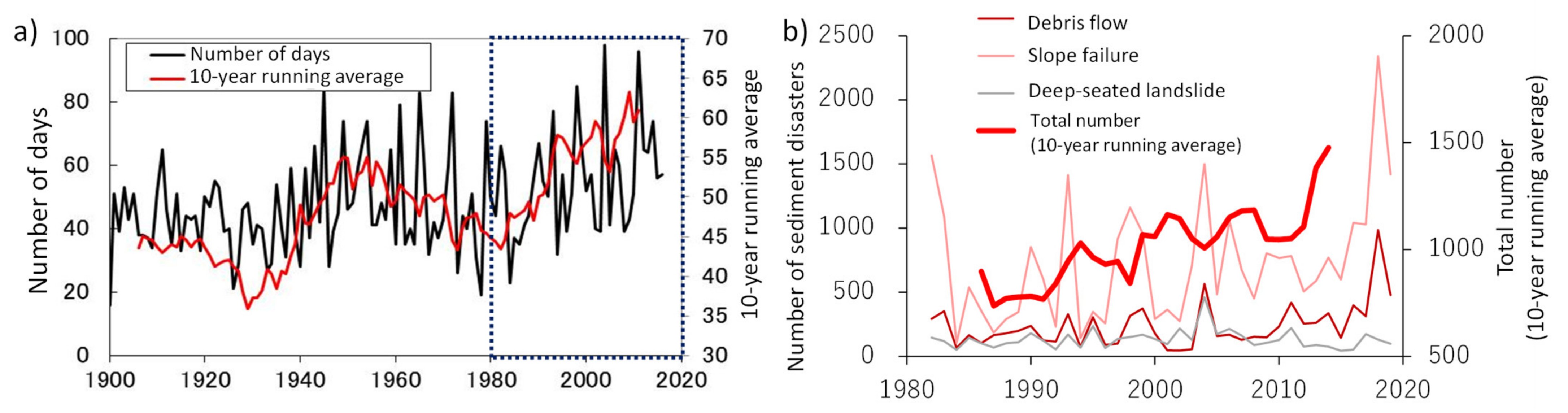
The JMA (Japan Meteorological Agency) reported that the observed changes to date include increases in the frequency of heavy rain and short-duration intense rainfall events. Moreover, at the end of the 21st century, the number of annual days with daily precipitation of 200 mm or more will increase by about 1.5 times; and the frequency of 1 h precipitation of 50 mm or more increases by about 1.6 times based on the 2 °C rise scenario (RCP2.6) of IPCC [31]. Figure 1 shows the relationship between the number of sediment disasters increasing from 1980 to 2019 with an increase in the number of days with precipitation of 100 mm or more [32]. In recent years, the number of sediment disasters in Japan has increased in accordance with the increase in heavy rainfall. In the torrential rains in July 2018, the MLIT reported 2581 cases of sediment disasters over a wide area, about 2.5 times the annual average, mainly in western Japan. In the following year 2019, Typhoon Hagibis, its heavy precipitation enhanced by historical warming [33], caused widespread sediment disasters in the Kanto and Tohoku regions [34], where sediment disasters had been relatively rare [35]. A total of 952 sediment disasters occurred, the highest number recorded for a single typhoon disaster since 1982. In this disaster, human casualties resulted from disasters that occurred in areas that were not designated as “Sediment Disaster Alert Areas” because the topographical conditions did not meet the criteria for designation in municipalities where heavy rainfall exceeding the criteria for the announcement of a JMA emergency warning was recorded [36]. Specifically, in Marumori, Miyagi Prefecture, causalities and property damage were caused by sediment-laden floods (Figure 2a) [37], and casualties and property damage were caused by debris flows in an area where the valley topography was unclear in Mawarikura (Figure 2b) [38], and casualties and property damage were caused by deep-seated landslides in an area where there was no clear deep-seated landslide topography in Tomioka, Gunma Prefecture (Figure 2c) [39]. In addition, these human casualties occurred in areas that did not meet the criteria for designation as Sediment Disaster Alert Areas. This suggests that, due to the intensification of heavy rainfall caused by climate change, the number of sediment disasters in areas where the number of such disasters has been small in the past is increasing, and that sediment disasters caused by sediment movement phenomena, which have been infrequent in the past, are becoming more apparent.
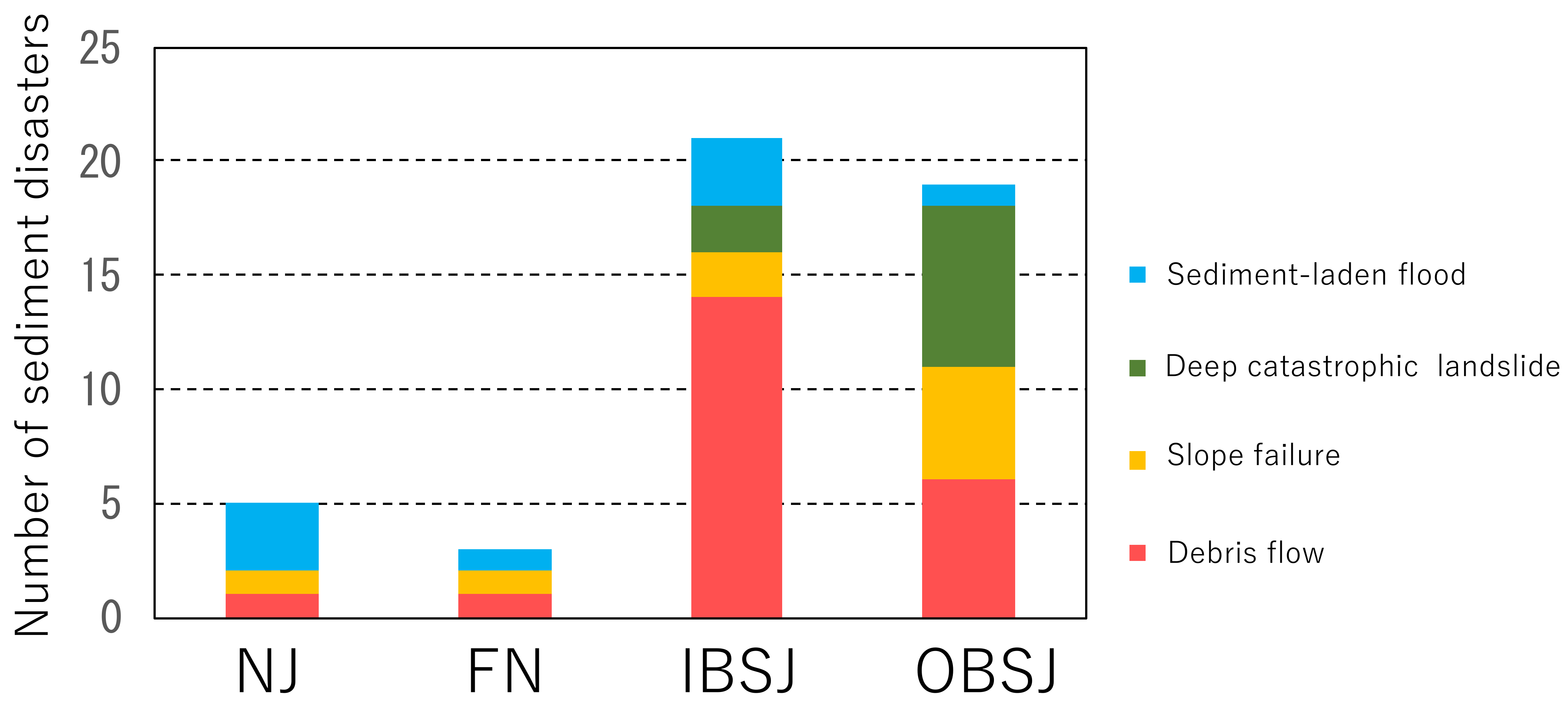
In the inner belt of Southwest Japan (IBSJ), where granitic geology is widely distributed, sediment disasters that cause major damage are often caused by the simultaneous occurrence of slope failures and debris flows due to torrential rains during the rainy season, while in the Pacific side of the outer belt of Southwest Japan (OBSJ), where accretionary geology is widely distributed, sediment disasters tend to be caused by deep-seated catastrophic (rapid) landslides due to typhoons [40]. Figure 3 shows 48 major sediment disasters from April 1998 to September 2020, in which 40 disasters caused five fatalities or more in one municipality, five deep-seated catastrophic (rapid) landslides [41,42,43,44] and three sediment-laden floods [45,46,47], in the geological structures of Northeast Japan (NJ), Fossa Magna (FN), IBSJ and OBSJ and indicates their tendency.
In the future, as climate change progresses, the influence of both typhoons and rainy season fronts will shift eastward and northward, which will further increase the amount of precipitation in western Kyushu and the Chugoku region, where many torrential rains have occurred in the past and are expected to cause torrential rains in Hokkaido, a region that has not had much precipitation in the past (refer to Figure 4 for locations of sub-region of Japan) [48,49].
In order to adapt to the increasing sediment disasters caused by climate change, it is necessary to properly assess which areas will experience more frequent sediment movement phenomena; this will become more apparent due to the changes in rainfall characteristics caused by climate change, and it is urgent to develop a new assessment method. Based on the relationship between future rainfall forecast data and the critical line method of Sediment Disaster Alert in Japan [14], studies are being conducted on where the frequency of sediment disasters will increase [50,51].
Based on the experience of recent major sediment disasters, the authors expect several outcomes as a result of climate change in Japan as follows: (1) increasing frequency of sediment disasters throughout Japan; (2) expansion of the damage area of sediment disaster; (3) occurrence of sediment disasters in regions where sediment disasters had been relatively rare; and (4) occurrence of sediment movement phenomena that would be more apparent due to climate change (such as sediment-laden flood and deep-seated landslides with no clear landslide topography on gentle slopes), which had been rare.
In particular, for sediment-laden floods and deep-seated landslides with no clear landslide topography on gentle slopes that are not covered by the present system for warning and evacuation [14,15], it is an important issue to establish a method to identify the hazardous area. Especially, as the frequent occurrence of sediment production in the mountainous area and the duration of flooding increases, the risk of damage caused by sediment-laden flood might become greater. Moreover, the frequent occurrence of simultaneous debris flows, which caused a large number of fatalities in the past due to the increase in precipitation caused by climate change, may be of concern. Recent and historical background and current challenges of sediment-laden floods and deep-seated landslides with no clear landslide topography on gentle slopes and simultaneous debris flow, are next explained in detail.
2.3. Sediment-Laden Floods and Deep-Seated Landslides with No Clear Landslide Topography on Gentle Slope and Simultaneous Debris Flows
The affected area and damage of sediment-laden floods are more extensive than those caused by debris flows, as they have recently occurred in urban areas with relatively gentle slopes, such as alluvial fans and valley plains in Japan [23,52]. Sediment-laden floods have often caused serious damage in the past in Japan. Moreover, the frequency of sediment-laden floods has been increasing from the 2010s (Figure 4) [37,43,46,47,53,54,55,56,57,58]. Sediment-laden floods occurred when active surface erosion and small-scale shallow landslides in the bare mountains and hills caused sediment to be constantly produced and deposited on slopes and streambeds due to rainfall before Japan’s rapid economic growth period (approximately from 1954 to 1973), such as the Great Hanshin Flood (1938) [59]. Sediment-laden floods and debris flows could also be enhanced by sediment production affected by the temporary loss of the mechanical soil binding effect of forest root systems due to the expansion of afforestation after World War II [60,61,62].
In such areas, for example, the damage caused by sediment-laden floods and debris flows was greatly reduced during the torrential rains in July 2018, even though the amount of precipitation around Mt. Rokko was higher than that of the Great Hanshin Flood [63]. The construction of hillside works, including afforestation, at the source of sediment production, and SABO dams and ground sills, in the middle and lower reach of streams, are considered to reduce erosion of hillside slopes and the discharge of sediment deposited on stream beds, to reduce sediment transport within the watershed and to prevent damage [64].
As tree felling decreased and vegetation recovered on bare mountains and hills after the energy revolution during Japan’s rapid economic growth period, the frequency of surface erosion and small-scale shallow landslides at mountains and hills decreased, and the development of forest soils and weathered bedrock layers increased in all regions of Japan.
As above, the sediment production patterns have changed dramatically compared to the time when bare mountains and hills were widespread. In recent years, sediment-laden floods that cause serious damage have been caused by the simultaneous occurrence of slope failures and debris flows even in forested watersheds. In unprecedented torrential rainfalls, sediment-laden floods caused by simultaneous slope failures and debris flows might occur on forested hillslopes, even in watersheds where structural measures for preventing sediment transport have been implemented and where there is little sediment transport in the small and medium magnitude of precipitation. When a sediment-laden flood occurs, slope failures and debris flow often produce large amounts of driftwood from hillsides, which might increase the damage.
Deep-seated landslides with no clear landslide topography on gentle slopes tend to occur where subsurface flow is prone to occur on bedrock, and are related to falling pyroclastic deposits that can be a slip surface due to weathered pumice layer [39,65]. Reviews of past incidents and on-site investigations are very important to understanding the generation mechanism and flow process of deep-seated landslides with no clear landslide topography on gentle slopes, and to establish risk assessment methods.
Simultaneous debris flows caused a large number of fatalities, especially in urban and suburban areas of Japan [56,66,67]. In sediment disasters caused by the torrential rains in July 2018, approximately 70% of the streams where fatalities were caused by sediment disasters were small streams with a basin area of 0.05 km2 or less. The percentage of streams with a basin area of 0.05 km2 or less is equivalent to about 35% of the approximately 180,000 streams of “Debris Flow Prone Torrents” (not legal designations, identification of risk against debris flow in Japan before designating the Sediment Disaster Alert Areas). Moreover, only three streams had SABO dams before the disasters in 33 streams where fatalities occurred. In response to this disaster, the report of the “Sediment disaster prevention study committee to Ensure Effective Evacuation” [68] established by the MLIT stated that “effective and efficient measures against debris flow in small streams should be promoted” as one of the measures to be taken in the future.
3. Challenges for Sediment Disaster Measures against Climate Change
3.1. Current Challenges of Sediment-Laden Floods
In order to take appropriate adaptation measures against sediment-laden floods, it is necessary to identify watersheds that produce large amounts of sediment due to slope failures and debris flows caused by changes in rainfall characteristics associated with climate change, which are prone to being transported and deposited near residential areas in downstream. However, it is difficult to establish a method for identifying such watersheds; thus, (1) watersheds where sediment-laden floods have occurred in the past; and (2) watersheds that have the same characteristics as watersheds, which recently experienced sediment-laden floods such as topography and potential sediment production, should be considered.
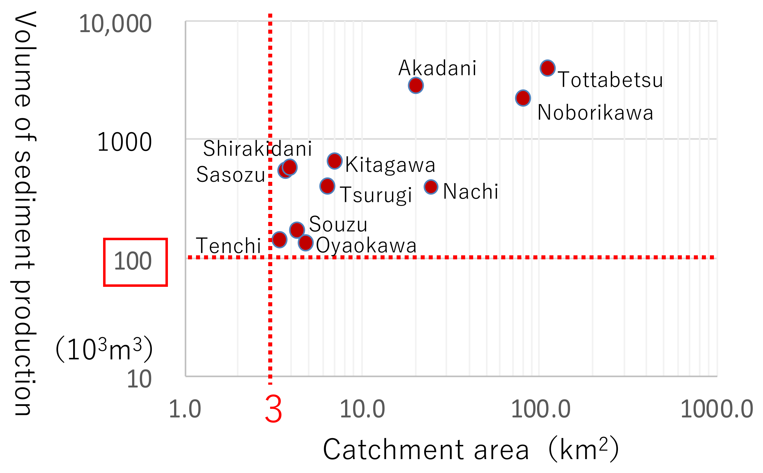
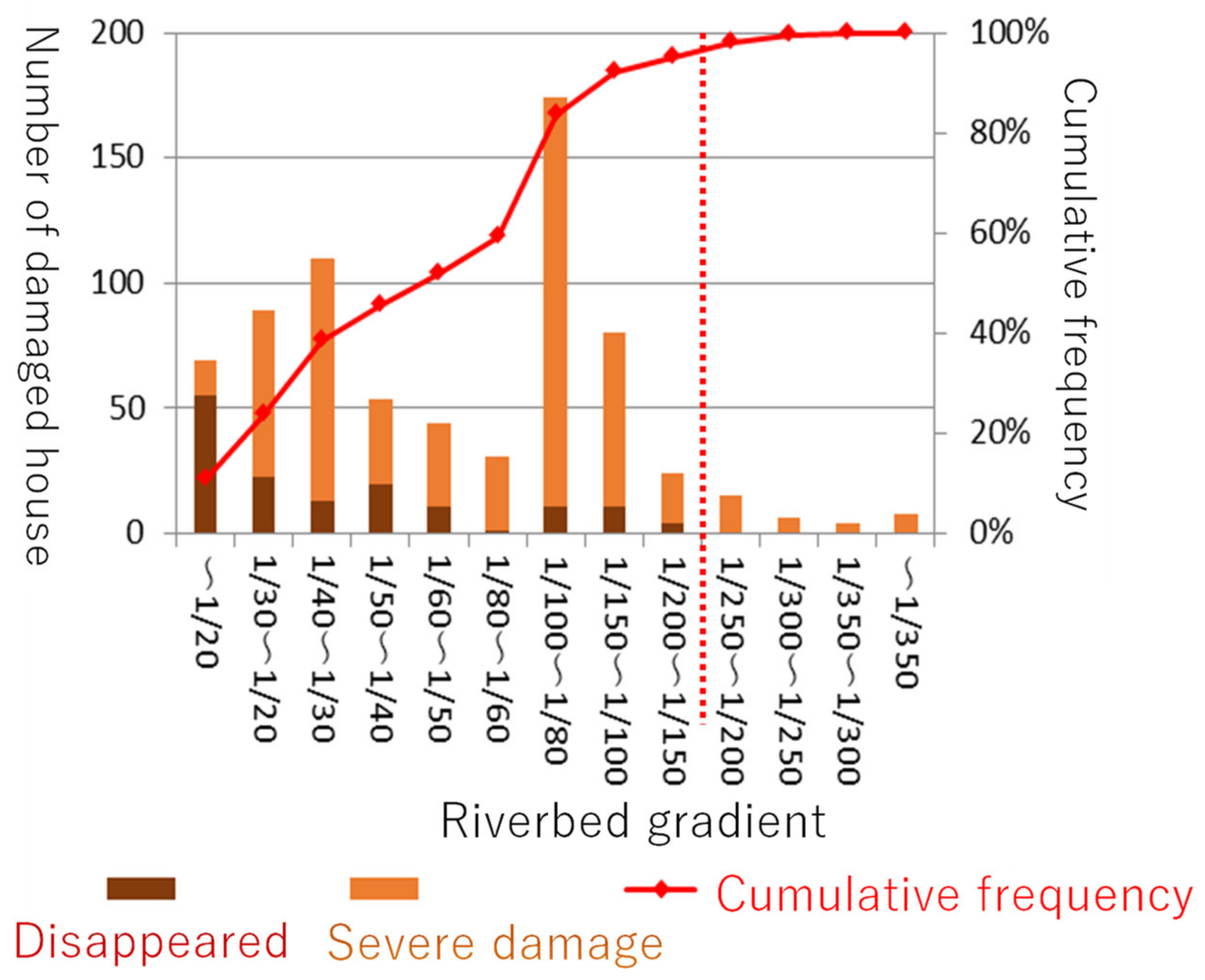
In Figure 5, relationships between catchment area and volume of sediment production of rivers that have experienced sediment-laden floods in recent years (from 2009 to 2018; 11 events in which sediment budgets in watersheds were measured by LiDAR) are shown. Sediment-laden floods tend to occur in watersheds with a catchment area of 3 km2 or more and more than 100,000 m3 of sediment production. In Figure 6, relationships between characteristics of damaged houses and river gradient; the Akadani river in heavy rainfall in northern Kyushu, 2017; the Sozu, Tenchi and Oyaokawa rivers in the torrential rains in July 2018, and the Gofukuya river in heavy rainfall caused by Typhoon Hagibis, 2019, are shown. At a riverbed gradient of 1/150~200 or steeper, the majority of severe damage was caused to houses, which were washed away in some cases [69,70]. Based on these tendencies, the MLIT published, “Draft guideline of investigation for watershed at risk of severe damage due to sediment and flood damage (Trial version)” [71] in March 2022, for the prefectural government as a risk assessment method against sediment-laden floods.
For the planning phase of the structural measures, Technical Criteria for River and SABO Works Basic Planning Part [25] was revised in 2019 to use planning methodologies based on riverbed variation calculations against sediment-laden floods. In 2021, for the MLIT projects in the Kizugawa River and the Kii mountains, which changed project plans based on riverbed variation calculations, continued implementation of the projects was approved by project evaluation [72,73], mainly based on cost–benefit analysis [74]. The MLIT projects against sediment-laden floods will continue to be reviewed [75], and the prefectural government will establish structural measure plans against sediment-laden floods [76] using riverbed variation calculations.
Driftwood brought by sediment-laden floods causes serious damage in downstream areas as a result of heavy rainfall in northern Kyushu, 2017 [43], in which the estimated volume of driftwoods was approximately 210,000 m3 [77]. The MLIT and Forestry Agency started to collaborate quantitatively on structural measures against driftwood, for example sharing the data of standing timbers surveyed by LiDAR and a measure plan [78].
3.2. Current Challenges of Deep-Seated Landslides with No Clear Landslide Topography on Gentle Slope
In order to establish an assessment method to clarify the risk of deep-seated landslides with no clear landslide topography on gentle slopes, Sugimoto et al. collected literature on 26 disasters and 71 cases of deep-seated landslides in Japan with no clear landslide topography on gentle slopes due to rainfall [79]. In their study, first, as an analysis of rainfall conditions for the occurrence of landslides, the ratio (hereafter R) of the maximum daily rainfall at the time of disasters to the 100-year probable daily rainfall (using the 100-year probable rainfall at the nearest point in the JMA website’s list [80] from the location of landslide) was calculated. R ≥ 1 accounts for 80% of the cases (57 cases), indicating that many of the cases occurred in rare heavy rains. In addition, as a topographical analysis of the occurrence of landslides, whether or not the landslide topography existed before the disaster in the literature was surveyed. The results show that 86% of the cases (61 cases) had no description of landslide topography, suggesting that many of the cases occurred on gentle slopes where no clear landslide topography was observed before the disaster. As an analysis of geology and geological structure, the ratios of geology and geological structure based on descriptions in the literature were surveyed. It was found that the number of deep-seated landslides with no clear landslide topography on gentle slopes occurring on slopes where pyroclastic fall deposits (Quaternary) formed dip slope was 15/71 cases (21%) and 5/26 disasters (19%), including the landslide in Takumi, Tomioka, Gunma in this category, and the number that occurred on slopes where marine sedimentary rocks (from Quaternary to Cretaceous) formed dip slopes was 15/71 cases (21%) and 9/26 disasters (35%). They reported that these two types of geology and geological structure might have relatively high risks of deep-seated landslides with no clear landslide topography on the gentle slopes.
3.3. Current Challenges of Simultaneous Debris Flows
Downstream of streams with small catchment areas in urban and suburban areas, developed housing areas are often located directly below their valley outlet, and once a debris flow occurs, it could cause extensive damage. Moreover, because narrow roads in crowded housing areas complicate the transport of construction materials and construction machines to build an SABO dam (check dam), it is difficult to build a conventional type of SABO dam. Therefore, it is important to effectively and efficiently install measures to build facilities against debris flow in such streams [81].
The MLIT published in 2022, “Technical supplement for structural measure against debris flow in streams with small catchment area and no flowing water” [78,82] as supplemental material for the technical standard for planning and design of conventional SABO dams [83,84], to promote the introduction of a simpler structure than the conventional SABO dam. This material is to be used under the following conditions.
A stream should have two characteristics, as follows: (1) an ephemeral stream where the flow path is unclear, there is no water flow on days with no rain, and sediment transport is not expected under rainfall that does not cause a sediment disaster; and (2) a stream where the riverbed slope gradient upstream of the planned SABO dam is 10° or steeper, and the entire watershed of the upper stream of the point is a debris flow generation/runoff zone. These guidelines also apply when it is difficult to construct an SABO dam based on the conventional guidelines from the viewpoint of constructability and topographical conditions, such as (1) when a road to the construction site is very narrow; (2) when the size of the conventional SABO dam might be significantly larger than the size of the stream watershed; (3) when a large amount of soil is excavated for construction of the SABO dam; or (4) when a new road for construction cannot be prepared due to the proximity of houses, buildings or any structures.
4. Discussion
In Section 2.2, we indicate several expected outcomes of climate change in Japan. For increasing frequency and expansion of the damage area of sediment disasters, and the occurrence of sediment disasters in regions where sediment disasters had been relatively rare (outcomes: from (1) to (3)), it may be essential to predict sediment movement phenomena that will become more frequent and more apparent in each region of Japan. To this end, it is important to analyze the dominant topographical and geological factors [40] and rainfall indexes [14,40,85] that caused each past sediment movement phenomena (such as simultaneous debris flows and slope failures, sediment-laden floods, and deep-seated catastrophic (rapid) landslide), based on these results, to predict the occurrence of future sediment movement phenomena for each region using future rainfall forecast data on a nationwide scale. If the dominant topographical and geological factors and rainfall indexes could be quantified, it would improve the dissemination of sediment risk information by taking into account the effects of climate change.
For the occurrence of sediment movement phenomena that would be more apparent due to climate change, which had been rare (outcome: (4)), especially regarding sediment-laden floods, it is important to assess the potential source of sediment, and the tendencies of sediment erosion and deposition in each river system, evaluated by the riverbed variation calculation [25] and connectivity of sediment transport in rivers [86], for the risk grading of watersheds at risk of sediment-laden floods to prioritize implementation of structural measures.
Moreover, the development and implementation of techniques for estimating sediment production based on physical models, such as numerical simulations [87,88,89,90], should be expedited so that the amount of sediment production in areas with inexperienced rainfall can be appropriately estimated to implement non-structural and structural measures from the viewpoint of the estimation of the damage area caused by each sediment movement phenomenon and external forces required for the design of facilities. Since the establishment of a physical model requires further validation and technological development, the use of an empirical method to estimate the amount of sediment production according to the predicted future rainfall based on the relationship between the amount of rainfall during past sediment disasters and the amount of sediment production should be facilitated [91]. In the use of empirical methods, extrapolation to a range of rainfall that has not been experienced at all is a major problem.
Because the spatial resolution of present future rainfall forecast data (for example spatial resolution of SI-CAT DDS5TK 5 km) is often large compared to the watershed area where structural measures are conducted against sediment-laden floods, debris flow, and slope failure [92], quantitative evaluation of water and sediment discharge on a local scale affected by climate change using future rainfall forecast data is also an important issue for the planning and design of facilities.
5. Conclusions
In this review, firstly non-structural and structural measures against sediment disasters in Japan conducted by the MLIT and the prefectural government, and the characteristics of recent major sediment disasters caused by heavy rainfall under the influence of climate change in Japan, mainly describing sediment disasters caused by the torrential rains in July 2018 and Typhoon Hagibis, are summarized as a recent and historical background. Secondly, based on the characteristics, problems that need to be resolved are shown, for example, sediment-laden floods and deep-seated landslides with no clear landslide topography on gentle slopes, which are not covered by the present system for warning and evacuation. Finally, current challenges to establishing advancing adaptation measures against such sediment disasters are introduced.
To establish proper adaptation measures against sediment disasters due to climate change, the SABO Department of the MLIT has been consulting with academic experts in the “SABO technical panel for climate change” since 2019. The interim report of the panel was published in June 2020 [93]. Based on the Interim report, the MLIT plans and conducts research and technical development to update technical standards for non-structural and structural measures. The MLIT continues to exchange ideas with countries and areas affected by sediment disasters due to climate change.
Author Contributions
S.-i.H.; software, validation, formal analysis, writing—original draft preparation, visualization, project administration, M.K.; conceptualization, methodology, writing—original draft preparation, supervision, project administration, K.M.; conceptualization, writing—review and editing, supervision, project administration, K.S.; software, validation, formal analysis, writing—original draft preparation, visualization, project administration. All authors have read and agreed to the published version of the manuscript.
Funding
This research received no external funding.
Institutional Review Board Statement
Not applicable.
Informed Consent Statement
Not applicable.
Data Availability Statement
Not applicable.
Acknowledgments
The authors would like to thank the anonymous reviewers whose comments significantly improved this paper.
Conflicts of Interest
The authors declare no conflict of interest.
References
- Petley, D. Global patterns of loss of life from landslides. Geology 2012, 40, 927–930. [Google Scholar] [CrossRef]
- Haque, U.; Blum, P.; da Silva, P.F.; Andersen, P.; Pilz, J.; Chalov, S.R.; Malet, J.P.; Jamec Auflic, M.; Andres, N.; Poyiadji, E.; et al. Fatal landslides in Europe. Landslides 2016, 13, 1545–1554. [Google Scholar] [CrossRef]
- Marc, O.; Stumpf, A.; Malet, J.P.; Gosset, M.; Uchida, T.; Chiang, S.H. Initial insights from a global database of rainfall-induced landslide inventories: The weak influence of slope and strong influence of total storm rainfall. Earth Syst. Dyn. 2018, 6, 903–922. [Google Scholar] [CrossRef] [Green Version]
- IPCC Sixth Assessment Report—Summary for Policymakers. Available online: https://www.ipcc.ch/report/ar6/wg1/downloads/report/IPCC_AR6_WGI_SPM.pdf (accessed on 13 July 2022).
- Stoffel, M.; Tiranti, D.; Huggel, C. Climate change impacts on mass movements—Case study from the European Alps. Sci. Total Environ. 2014, 493, 1255–1266. [Google Scholar] [CrossRef] [PubMed]
- Gariano, S.L.; Guzzetti, F. Landslides in a changing climate. Earth-Sci. Rev. 2016, 162, 227–252. [Google Scholar] [CrossRef] [Green Version]
- Gariano, S.L.; Rianna, G.; Petrucci, O.; Guzzetti, F. Assessing future changes in the occurrence of rainfall-induced landslides at a regional scale. Sci. Total Environ. 2017, 596–597, 417–426. [Google Scholar] [CrossRef]
- Haque, U.; da Silva, P.F.; Devoli, G.; Pilz, J.; Zhao, B.; Khaloua, A.; Wilopo, W.; Andersen, P.; Lu, P.; Lee, J.; et al. The human cost of global warming: Deadly landslides and their triggers (1995–2014). Sci. Total Environ. 2019, 682, 673–684. [Google Scholar] [CrossRef]
- Kanbara, J.; Imamori, N. Outline of measures for sediment disaster by the Sabo department of MLIT, Japan. Landslides 2020, 17, 2503–2513. [Google Scholar]
- Ministry of the Environment—Publication of Report on Assessment of Impacts of Climate Change in Japan and Future Challenges. Available online: https://www.env.go.jp/press/108790.html (accessed on 29 April 2022).
- e-GOV—Climate Change Adaptation Act. Available online: https://elaws.e-gov.go.jp/document?law_unique_id=430AC0000000050_20181201_000000000000000 (accessed on 29 April 2022).
- Cabinet Office—Public Opinion Survey on Water Circulation (October 2020 Survey). Available online: https://survey.gov-online.go.jp/hutai/r02/r02-mizug.pdf (accessed on 29 April 2022).
- Mizuyama, T. Sediment hazards and SABO works in Japan. Int. J. Eros. Control Eng. 2008, 1, 1–4. [Google Scholar] [CrossRef] [Green Version]
- Osanai, N.; Shimizu, T.; Kuramoto, K.; Kojima, S.; Noro, T. Japanese early-warning for debris flows and slope failures using rainfall indices with radial basis function network. Landslides 2010, 7, 325–338. [Google Scholar] [CrossRef]
- Uchida, T.; Nishimoto, H.; Osanai, N.; Shimizu, T. Countermeasures for sediment-related disasters in Japan using hazard maps. Int. J. Eros. Control Eng. 2009, 2, 46–53. [Google Scholar] [CrossRef] [Green Version]
- Ministry of Land, Infrastructure, Transport and Tourism—Designation of Sediment Disaster Alert Areas. Available online: https://www.mlit.go.jp/mizukokudo/sabo/content/001465798.pdf (accessed on 29 April 2022).
- e-GOV—Sediment Disaster Prevention Act. Available online: https://elaws.e-gov.go.jp/document?lawid=412AC0000000057 (accessed on 29 April 2022).
- e-GOV—Sabo Act. Available online: https://elaws.e-gov.go.jp/document?lawid=130AC0000000029 (accessed on 29 April 2022).
- e-GOV—Landslide Prevention Act. Available online: https://elaws.e-gov.go.jp/document?lawid=333AC0000000030 (accessed on 29 April 2022).
- e-GOV—Steep Slope Failure Prevention Act. Available online: https://elaws.e-gov.go.jp/document?lawid=344AC0000000057_20150801_000000000000000 (accessed on 29 April 2022).
- Mizuyama, T. Structural countermeasures for debris flow disasters. Int. J. Eros. Control Eng. 2008, 1, 38–43. [Google Scholar] [CrossRef] [Green Version]
- Ministry of Land, Infrastructure, Transport and Tourism—Sediment-Laden Flood. Available online: https://www.mlit.go.jp/common/001296657.pdf (accessed on 29 April 2022).
- Hasegawa, Y.; Nakatani, K.; Araki, Y.; Kaibori, M.; Satofuka, Y. Study on sediment disasters occurred in Tennou, Kure city, Hiroshima prefecture and considering sediment and flood damage in down stream area. J. Jpn. Soc. Civ. Eng. Ser. B1 2019, 75, 324–331. [Google Scholar] [CrossRef]
- Harada, D.; Nagumo, N.; Nakamura, Y.; Egashira, S. Characteristics of flood flow with active sediment transport in the Sozu river flood hazards at the severe rainfall event in July 2018. J. Disaster Res. 2019, 14, 886–893. [Google Scholar] [CrossRef]
- Ministry of Land, Infrastructure, Transport and Tourism—Technical Criteria for River and SABO Works Basic Planning Part. Available online: https://www.mlit.go.jp/river/shishin_guideline/gijutsu/gijutsukijunn/keikaku/index.html (accessed on 19 July 2022).
- Kinki Regional Development Bureau, Ministry of Land, Infrastructure, Transport and Tourism—The Great Flood in the Kii Peninsula, The Record of Disaster Response of the Kinki Regional Development Bureau, Ministry of Land, Infrastructure, Transport and Tourism. Available online: https://www.kkr.mlit.go.jp/bousai/qgl8vl0000008ajd-att/kiihantou-kirokushi.pdf (accessed on 19 July 2022).
- Sasaki, M. Measures of sediment disasters after 2011 eruption of Shinmoe-dake, Kirishima Volcano. J. Jpn. Soc. Eros. Control Eng. 2014, 66, 88–91. [Google Scholar]
- Council for landslide disaster management in Niigata Prefecture. Activities of Council for landslide disaster management in Niigata Prefecture. J. Jpn. Landslide Soc. 2017, 54, 68–71. [Google Scholar] [CrossRef]
- Uchida, T.; Yamakoshi, T.; Shimizu, T.; Yoshino, K.; Kisa, H.; Ishiduka, T. Quick analysis method for assessing debris flow hazard area induced by overtopping erosions of landslide dam and post-eruption rainstorm. Civ. Eng. J. 2011, 53, 18–23. [Google Scholar]
- Public Works Research Institute, Japan—Development of an Open Source Program for Parallel Computation of Inundation by Stony Debris Flow, Immature Stony Debris Flow and Bed Load. Available online: https://www.pwri.go.jp/jpn/results/db/doken_kankoubutu/doken_shiryou/files/doken_shiryou_4415_00.pdf (accessed on 19 July 2022).
- Japan Meteorological Agency—Climate Change in Japan, December 2020. Available online: https://www.data.jma.go.jp/cpdinfo/ccj/2020/pdf/cc2020_gaiyo_en.pdf (accessed on 8 July 2022).
- Uchida, T.; Sakurai, W.; Okamoto, A. Historical Patterns of Heavy Rainfall Event and Deep-Seated Rapid Landslide Occurrence in Japan: Insight for Effects of Climate Change on Landslide Occurrence. In Advancing Culture of Living with Landslides; Mikoš, M., Casagli, N., Yin, Y., Sassa, K., Eds.; Springer: Cham, Switzerland, 2017; pp. 251–257. [Google Scholar]
- Kawase, H.; Yamaguchi, M.; Imada, Y.; Hayashi, S.; Murata, A.; Nkaegawa, T.; Miyasaka, T.; Takayabu, I. Enhancement of extremely heavy precipitation induced by Typhoon Hagibis (2019) due to historical warming. SOLA 2021, 17A, 7–13. [Google Scholar] [CrossRef]
- Ministry of Land, Infrastructure, Transport and Tourism—Problems Based on Recent Sediment Disaster Experience. Available online: https://www.mlit.go.jp/river/sabo/committee_kikohendo/200521/02shiryo.pdf (accessed on 29 April 2022).
- Saito, H.; Korup, O.; Uchida, T.; Hayashi, S.; Oguchi, T. Rainfall conditions, typhoon frequency, and contemporary landslide erosion in Japan. Geology 2014, 42, 999–1002. [Google Scholar] [CrossRef] [Green Version]
- Japan Meteorological Agency—Emergency Warning System. Available online: https://www.jma.go.jp/jma/en/Emergency_Warning/ew_index.html (accessed on 29 April 2022).
- Irasawa, M.; Koi, T.; Tsuo, C.Y.; Kato, N.; Matsuo, S.; Arai, M.; Kaibori, M.; Yamada, T.; Kasai, M.; Wakahara, T.; et al. October 2019 sediment disaster in the Tohoku region owing to Typhoon No. 19 (Tyhpoon Hagibis). Int. J. Eros. Control Eng. 2020, 13, 48–55. [Google Scholar] [CrossRef]
- National Institute for Land and Infrastructure Management, Japan—Report on the Investigation of Infrastructures and Building Damages Caused by Typhoon No.15 and No.19 in 2019. Available online: http://www.nilim.go.jp/lab/bcg/siryou/tnn/tnn1111pdf/ks1111.pdf (accessed on 19 July 2022).
- Shuin, Y.; Uchida, T.; Kaibori, M.; Takeshita, W.; Tobioka, S.; Nishiwaki, A.; Yamakoshi, T. Sediment disasters in the Kanto area caused by heavy rains in October 2019, Typhoon Hagibis and locally developed front. J. Jpn. Soc. Eros. Control Eng. 2020, 72, 54–62. [Google Scholar]
- Nishiuchi, T.; Miyase, M.; Kunita, K.; Hamaji, R.; Hayashi, S.; Matsumoto, H.; Kito, M.; Sakai, Y.; Yamada, T.; Shibata, S. Characterization of dominant predisposing and triggering factors that are highly relevant to sediment transport phenomena. In Proceedings of the Annual Meeting, Japan Society of Erosion Control Engineering, Online, 19–21 May 2021; pp. 11–12. [Google Scholar]
- Taniguchi, Y.; Uchida, T.; Omura, H.; Ochiai, H.; Kaibori, M.; Kubota, T.; Sasahara, K.; Jitousono, T.; Shimizu, O.; Shimokawa, E.; et al. Sediment disasters caused by typhoon Nabi (T 0514) in September 2005. J. Jpn. Soc. Eros. Control Eng. 2005, 58, 46–53. [Google Scholar]
- Sasahara, K.; Kato, H.; Sakurai, W.; Ishizuka, T.; Kaji, A. Large-scale landslides occurred at eastern part of Kochi Pref. due to Typhoon No.6, 2011. J. Jpn. Soc. Eros. Control Eng. 2011, 64, 39–45. [Google Scholar]
- Marutani, T.; Kaibori, M.; Jitousono, T.; Mizuno, H.; Ohno, H.; Shimizu, O.; Kubota, T.; Ue, H.; Kanazawa, A.; Kawano, T.; et al. Sediment-related disasters by a heavy rainfall in the northern part of Kyushu-Island, Japan in July 2017. J. Jpn. Soc. Eros. Control Eng. 2017, 70, 31–42. [Google Scholar]
- Satofuka, Y.; Kosugi, K.; Nakatani, K.; Masaoka, N.; Okano, K.; Kasahara, T.; Yanagisaki, G.; Yamaguchi, Y. Disasters occurred in Kansai region due to the heavy rain event of July 2018. J. Jpn. Soc. Eros. Control Eng. 2018, 71, 38–48. [Google Scholar]
- Hashinoki, T.; Mizuyama, T.; Satoh, K.; Murakami, M. Research on sediment yield and sediment discharge which considers timing of sediment yield. J. Jpn. Soc. Eros. Control Eng. 2007, 59, 15–22. [Google Scholar]
- Furuichi, T.; Osanai, N.; Hayashi, S.; Izumi, N.; Kyuka, T.; Shiono, Y.; Miyazaki, T.; Hayakawa, T.; Nagano, N.; Matsuoka, N. Disastrous sediment discharge due to typhoon-induced heavy rainfall over fossil periglacial catchments in western Tokachi, Hokkaido, northern Japan. Landslides 2018, 15, 1645–1655. [Google Scholar] [CrossRef]
- Kitahara, K.; Fujimoto, K.; Fujii, T.; Osegi, H.; Tokunaga, S.; Takahashi, M.; Sato, T. Sediment-laden flood caused by Typhoon Hagibis in Saku area, Nagano Prefecture. In Proceedings of the Annual Meeting, Japan Society of Erosion Control Engineering, Online, 19–21 May 2021; pp. 25–26. [Google Scholar]
- Osakada, Y.; Nakakita, E. Future changes of “Baiu heavy rainfall duration and accumulated precipitation” using the regional climate model verified with past real heavy rainfall events. J. Jpn. Soc. Civ. Eng. Ser. B1 2018, 74, I_19–I_24. [Google Scholar] [CrossRef]
- Osakada, Y.; Nakamura, A.; Nakakita, E. Statistical analysis of future changes ㏌ baiu heavy rainfall duration and accumulated rainfall considering its spatio-temporal characteristics. J. Jpn. Soc. Civ. Eng. Ser. B1 2020, 76, I_7–I_12. [Google Scholar] [CrossRef]
- Wu, Y.H.; Nakakita, E.; Kunitomo, M. Future change of rainfall-triggered landslide risk using NHRCM05 based on critical line method. J. Jpn. Soc. Civ. Eng. Ser. B1 2020, 76, I_67–I_72. [Google Scholar] [CrossRef]
- Wu, Y.H.; Nakakita, E.; Yamaji, A. Future change of snake line pattern and its relation to sediment disasters. J. Jpn. Soc. Civ. Eng. Ser. B1 2021, 77, I_193–I_198. [Google Scholar] [CrossRef]
- Uchida, T.; Sakai, Y. Sediment and flood damage as a characteristic form of sediment disaster and its countermeasures. In Proceedings of the Annual Meeting, Japan Society of Erosion Control Engineering, Morioka, Japan, 21–23 May 2021; pp. 7–8. [Google Scholar]
- Furukawa, K.; Kaibori, M.; Kubota, T.; Jirousono, T.; Gonda, Y.; Sugihara, S.; Hayashi, S.; Ikeda, A.; Araki, Y.; Kashiwabara, Y. Debris disasters caused by heavy rainfall around Hofu City in Yamaguchi Prefecture on July 21, 2009. J. Jpn. Soc. Eros. Control Eng. 2009, 62, 62–67. [Google Scholar]
- Matsumura, K.; Fujita, M.; Yamada, T.; Gonda, Y.; Numamoto, S.; Tsutsumi, D.; Nakatani, K.; Imaizumi, F.; Shimada, T.; Kaibori, M.; et al. Sediment disasters due to typhoon No.12 at 2011, occurred in Kii peninsula. J. Jpn. Soc. Eros. Control Eng. 2012, 64, 43–53. [Google Scholar]
- Nagumo, N.; Egashira, S. Geomorphological analysis on flood and sediment hazards in the Omoto River resulting from Typhoon Lionrock in 2016. Trans. Jpn. Geomorphol. Union 2018, 39, 47–66. [Google Scholar]
- Kaibori, M.; Hasegawa, Y.; Yamashita, Y.; Sakida, H.; Nakai, S.; Kuwada, S.; Hiramatsu, S.; Jitousono, T.; Irasawa, M.; Shimizu, O.; et al. Sediment related disaster due to heavy rainfall in Hiroshima Prefecture in July 2018. J. Jpn. Soc. Eros. Control Eng. 2018, 71, 49–60. [Google Scholar]
- Jitousono, T.; Igura, M.; Ue, H.; Ohishi, H.; Kakimoto, T.; Kitou, K.; Koga, S.; Sakai, Y.; Sakashima, T.; Shinohara, Y.; et al. Sediment disasters in Kumamoto Prefecture by a heavy rainfall in July 2020. J. Jpn. Soc. Eros. Control Eng. 2020, 73, 41–50. [Google Scholar]
- Sakai, Y.; Yamada, Y.; Sakata, T.; Yamakoshi, T.; Miyase, M.; Sakai, N.; Hayashi, S. Sediment disasters in the Gebasawa River, Chino, Nagano Prefecture on September 2021. J. Jpn. Soc. Eros. Control Eng. 2022, 75, 35–40. [Google Scholar]
- Rokko SABO Office—The Great Hanshin Flood. 1938. Available online: https://www.kkr.mlit.go.jp/rokko/disaster/history/s13/s13-index.php (accessed on 29 March 2022).
- Tada, Y.; Sanmori, T.; Daimaru, H.; Koyama, K.; Kawai, T. Changes in Forests and Sediment Disaster over the Past 100 Years; Japan Society of Erosion Control Engineering: Tokyo, Japan, 2010; pp. 32–33. [Google Scholar]
- Ide, M. Looking back upon forest conservation (Chisan) measures of the last 100 years in Japan. J. Jpn. Soc. Eros. Control Eng. 2011, 64, 40–48. [Google Scholar]
- Shuin, Y. Changes in Japan’s forests and sediment disaster caused by heavy rainfall. Sci. Fire Disaster Prev. 2021, 143, 40–46. [Google Scholar]
- Rokko SABO Office—Effects of Sabo Facilities against the Torrential Rains in July Heisei 30. Available online: https://www.mlit.go.jp/river/sabo/jirei/h30dosha/H30koukajirei_rokkou_jigyo.pdf (accessed on 29 March 2022).
- Shinohara, Y.; Kume, T. Changes in the factors contributing to the reduction of landslide fatalities between 1945 and 2019 in Japan. Sci. Total Environ. 2022, 827, 154392. [Google Scholar] [CrossRef]
- Sugimoto, H.; Uto, T.; Honma, H.; Takeshi, T. Features of landslides induced by the 2011 off the Pacific Coast of Tohoku Earthquake, in Shirakawa hills. Civ. Eng. J. 2012, 54, 18–21. [Google Scholar]
- Kaibori, M.; Ishikawa, Y.; Ushiyama, M.; Kubota, T.; Hiramatsu, S.; Fujita, M.; Miyoshi, I.; Yamashita, Y. Debris flow and slope failure disasters in Hiroshima Prefecture caused by feavy rainfall in June, 1999 (Prompt Report). J. Jpn. Soc. Eros. Control Eng. 1999, 52, 34–43. [Google Scholar]
- Kaibori, M.; Ishikawa, Y.; Satufuka, Y.; Matsumura, K.; Nakatani, K.; Hasegawa, Y.; Matsumoto, N.; Takahara, T.; Fukatsuka, K.; Yoshino, K.; et al. Sediment-related disasters induced by a heavy rainfall in Hiroshima-city on 20th August, 2014. J. Jpn. Soc. Eros. Control Eng. 2014, 67, 49–59. [Google Scholar]
- Ministry of Land, Infrastructure, Transport and Tourism—The Report of the Sediment Disaster Prevention Study Committee to Ensure Effective Evacuation. Available online: https://www.mlit.go.jp/river/sabo/committee_jikkousei/190529/hokokusyo.pdf (accessed on 29 March 2022).
- Sakai, Y.; Tsushima, M.; Yamakoshi, T. Sediment yield in recent events with sediment and flood damage. Civ. Eng. J. 2021, 63, 30–35. [Google Scholar]
- Sakai, Y.; Tsushima, M.; Yamakoshi, T. Topographic analysis of damaged houses on sediment and flood damage. Civ. Eng. J. 2021, 63, 30–35. [Google Scholar]
- Ministry of Land, Infrastructure, Transport and Tourism—Draft Guideline of Investigation for Watershed at Risk of Severe Damage due to Sediment and Flood Damage (Trial version). Available online: https://www.mlit.go.jp/river/shishin_guideline/sabo/dosyakouzuihanran_youryou_r0403.pdf (accessed on 29 March 2022).
- Kinki Regional Development Bureau, Ministry of Land, Infrastructure, Transport and Tourism—Revaluation of Kizugawa River project. Available online: https://www.kkr.mlit.go.jp/plan/ippan/zigyohyoka/ol9a8v000003p9bu-att/no.3.pdf (accessed on 29 March 2022).
- Kinki Regional Development Bureau, Ministry of Land, Infrastructure, Transport and Tourism—Revaluation of Kii moutains project. Available online: https://www.kkr.mlit.go.jp/plan/ippan/zigyohyoka/ol9a8v000004e27l-att/no.4.pdf (accessed on 29 March 2022).
- Ministry of Land, Infrastructure, Transport and Tourism—Manual for Cost-Benefit Analysis of SABO Project (Draft). Available online: https://www.mlit.go.jp/river/sabo/zigyo_hyokasyuho/manualsabo.pdf (accessed on 29 March 2022).
- Marushita, J.; Kiyotsuna, Y.; Kano, K.; Tanigawa, Y.; Ikeshima, T. A case study of planning measure against sediment and flood damage in the watershed of Tenjin river. In Proceedings of the Annual Meeting, Japan Society of Erosion Control Engineering, Miyazaki, Japan, 11–13 May 2022; pp. 481–482. [Google Scholar]
- Kobayashi, Y.; Mori, K.; Kato, Y.; Ochi, T.; Sugiyama, S.; Mori, M.; Nakata, H. A case study of analysis against sediment and flood damage for facility layout plan. Proceedings of annual meeting, Japan Society of Erosion Control Engineering, Online, 19–21 May 2021; pp. 29–30. [Google Scholar]
- Ministry of Land, Infrastructure, Transport and Tourism—Summary of Sediment Disasters Caused by Heavy Rainfall in Northern Kyushu, July Heisei 29. Available online: https://www.mlit.go.jp/river/sabo/h29_kyushu_gouu/gaiyou.pdf (accessed on 29 March 2022).
- Ministry of Land, Infrastructure, Transport and Tourism—5th SABO Technical Panel for Climate Change, Material No.4 Others. Available online: https://www.mlit.go.jp/river/sabo/committee_kikohendo/220422/06siryou4.pdf (accessed on 29 March 2022).
- Sugimoto, H.; Kamiyama, J.; Fujiwara, K.; Hayashi, S.; Matsumoto, H.; Kito, M.; Sugawara, H.; Kanai, S.; Fujimoto, R.; Okazaki, T.; et al. An investigation of inventory and conditions for occurrence of deep-seated landslide with no clear landslide topography on gentle slope. Proceedings of Annual Meeting, Japan Society of Erosion Control Engineering, Online, 19–21 May 2021; pp. 263–264. [Google Scholar]
- Japan Meteorological Agency—Table of Probable Rainfall (51 locations). Available online: https://www.data.jma.go.jp/cpdinfo/riskmap/qt_table.html (accessed on 29 March 2022).
- Mizuyama, T.; Wada, H.; Yoshida, K. Debris flow control structures installed in zero-order torrents—A debris flow fence. J. Jpn. Soc. Eros. Control Eng. 2009, 62, 74–76. [Google Scholar]
- Ministry of Land, Infrastructure, Transport and Tourism—Technical Supplement for Structural Countermeasure against Debris Flow in Streams with Small Catchment Area and No Flowing Water (Trial version). Available online: https://www.mlit.go.jp/river/shishin_guideline/sabo/muryuusuikeiryuu_ryuuizikou_r0403.pdf (accessed on 29 March 2022).
- Sabo Planning Division, National Institute for Land and Infrastructure Management, Japan. Manual of Technical Standard for Establishing Sabo Master Plan for Debris Flow and Driftwood. Available online: http://www.nilim.go.jp/lab/bcg/siryou/tnn/tnn0904.htm (accessed on 19 July 2022).
- Sabo Planning Division, National Institute for Land and Infrastructure Management, Japan. Manual of Technical Standard for Designing Sabo Facilities against Debris Flow and Driftwood. Available online: http://www.nilim.go.jp/lab/bcg/siryou/tnn/tnn0905.htm (accessed on 19 July 2022).
- Suzuki, M.; Kobashi, S. The critical rainfall for the disasters caused by slope failures. J. Jpn. Soc. Eros. Control Eng. 1981, 34, 16–26. [Google Scholar]
- Shiomi, R.; Otsubo, R.; Ieta, Y.; Kiyono, M.; Nakanishi, H.; Sakai, Y.; Uchida, T. Topographic characteristics of erosion and deposition sites in watersheds caused sediment and flood damage. In Proceedings of the Annual Meeting, Japan Society of Erosion Control Engineering, Morioka, Japan, 21–23 May 2021; pp. 423–424. [Google Scholar]
- Tomita, Y.; Mori, T.; Miya, T.; Musashi, Y.; Suzuki, T.; Mizuyama, T. Development of sediment discharge model and deformation of riverbed model for watershed-management system (WMS). J. Jpn. Soc. Eros. Control Eng. 2014, 66, 3–12. [Google Scholar]
- Yamanoi, K.; Fujita, M. Risk estimation of multiple hazards related to sediment and water disasters occurring in heavy rainfall. J. Jpn. Soc. Civ. Eng. Ser. B1 2016, 72, I_1291–I_1296. [Google Scholar]
- Matsushi, Y.; Toyama, M.; Matsuzaki, H.; Chigira, M. Simulation of Soil Production and Transport for Prediction of Location and Magnitude of Shallow Landslides. Trans. Jpn. Geomorphol. Union 2016, 37, 427–453. [Google Scholar]
- Yamazaki, Y.; Egashira, S. Method to estimate landslide and their runout during heavy rainfall. J. Jpn. Soc. Civ. Eng. Ser. B1 2020, 76, I_1093–I_1098. [Google Scholar] [CrossRef]
- Kunitoki, M.; Hayashi, S.; Matsumoto, H.; Kito, M.; Yamakoshi, T.; Sakai, Y.; Uchida, T.; Ikeda, H.; Kawai, E.; Sugihara, S. Study on the estimation method of produced sediment volume using the results of interpretation for slope failure and debris flow. In Proceedings of the Annual Meeting, Japan Society of Erosion Control Engineering, Online, 19–21 May 2021; pp. 567–568. [Google Scholar]
- Fujita, A.; Suzuki, K.; Toda, M.; Kawabe, M.; Tanigawa, Y.; Ogawa, S.; Matsunaga, Y.; Makino, H. Basic study for setting design rainfall based on future rainfall forecast data in Uonuma region. Proceedings of Annual Meeting, Japan Society of Erosion Control Engineering, Miyazaki, Japan, 11–13 May 2022; pp. 61–62. [Google Scholar]
- Ministry of Land, Infrastructure, Transport and Tourism—Interim Report of SABO Technical Panel for Climate Change. Available online: https://www.mlit.go.jp/river/sabo/committee_kikohendo/200521/chukan_torimatome.pdf (accessed on 29 March 2022).
Figure 1.
The relationship between the number of sediment disasters increasing from 1980 to 2019 with an increase in the number of days with precipitation of 100 mm or more: (a) The numbers of days with precipitation of 100 mm or more and 10-year running average in 51 observation stations in Japan (based on Uchida et. al., 2017 [32]), (b) the number of sediment disasters and 10-year running average, reported by the MLIT, from 1980 to 2019 in Japan.

Figure 2.
Photos of sediment disasters caused by Typhoon Hagibis 2019: (a) sediment-laden flood, (b) debris flows in an area where the valley topography was unclear, (c) deep-seated landslides in an area where there was no clear deep-seated landslide topography (courtesy of Pasco Corporation).
Figure 2.
Photos of sediment disasters caused by Typhoon Hagibis 2019: (a) sediment-laden flood, (b) debris flows in an area where the valley topography was unclear, (c) deep-seated landslides in an area where there was no clear deep-seated landslide topography (courtesy of Pasco Corporation).

Figure 3.
Type of major sediment disasters from April 1998 to September 2020 in geological structure: NJ (Northeast Japan), FN (Fossa Magna), IBSJ (the inner belt of Southwest Japan), OBSJ (the outer belt of Southwest Japan).
Figure 3.
Type of major sediment disasters from April 1998 to September 2020 in geological structure: NJ (Northeast Japan), FN (Fossa Magna), IBSJ (the inner belt of Southwest Japan), OBSJ (the outer belt of Southwest Japan).

Figure 4.
Distribution of recent sediment-laden floods in Japan since 2009.

Figure 5.
Relationships between catchment area and volume of sediment production of rivers that have experienced sediment-laden floods from 2009 to 2018 (cited from Sakai et al., 2021 [69]).
Figure 5.
Relationships between catchment area and volume of sediment production of rivers that have experienced sediment-laden floods from 2009 to 2018 (cited from Sakai et al., 2021 [69]).

Figure 6.
Relationships between characteristics of damaged houses and river gradient (cited from Sakai et al., 2021 [70]).
Figure 6.
Relationships between characteristics of damaged houses and river gradient (cited from Sakai et al., 2021 [70]).

Publisher’s Note: MDPI stays neutral with regard to jurisdictional claims in published maps and institutional affiliations. |
© 2022 by the authors. Licensee MDPI, Basel, Switzerland. This article is an open access article distributed under the terms and conditions of the Creative Commons Attribution (CC BY) license (https://creativecommons.org/licenses/by/4.0/).
Share and Cite
MDPI and ACS Style
Hayashi, S.-i.; Kunitomo, M.; Mikami, K.; Suzuki, K. Recent and Historical Background and Current Challenges for Sediment Disaster Measures against Climate Change in Japan. Water 2022, 14, 2285. https://doi.org/10.3390/w14152285
AMA Style
Hayashi S-i, Kunitomo M, Mikami K, Suzuki K. Recent and Historical Background and Current Challenges for Sediment Disaster Measures against Climate Change in Japan. Water. 2022; 14(15):2285. https://doi.org/10.3390/w14152285
Chicago/Turabian StyleHayashi, Shin-ichiro, Masaru Kunitomo, Koso Mikami, and Keisuke Suzuki. 2022. "Recent and Historical Background and Current Challenges for Sediment Disaster Measures against Climate Change in Japan" Water 14, no. 15: 2285. https://doi.org/10.3390/w14152285
Note that from the first issue of 2016, this journal uses article numbers instead of page numbers. See further details here.