
Monitoring and Analysis of Water Level–Water Storage Capacity Changes in Ngoring Lake Based on Multisource Remote Sensing Data

 , ,
, ,
Abstract
:1. Introduction
2. Materials and Methods
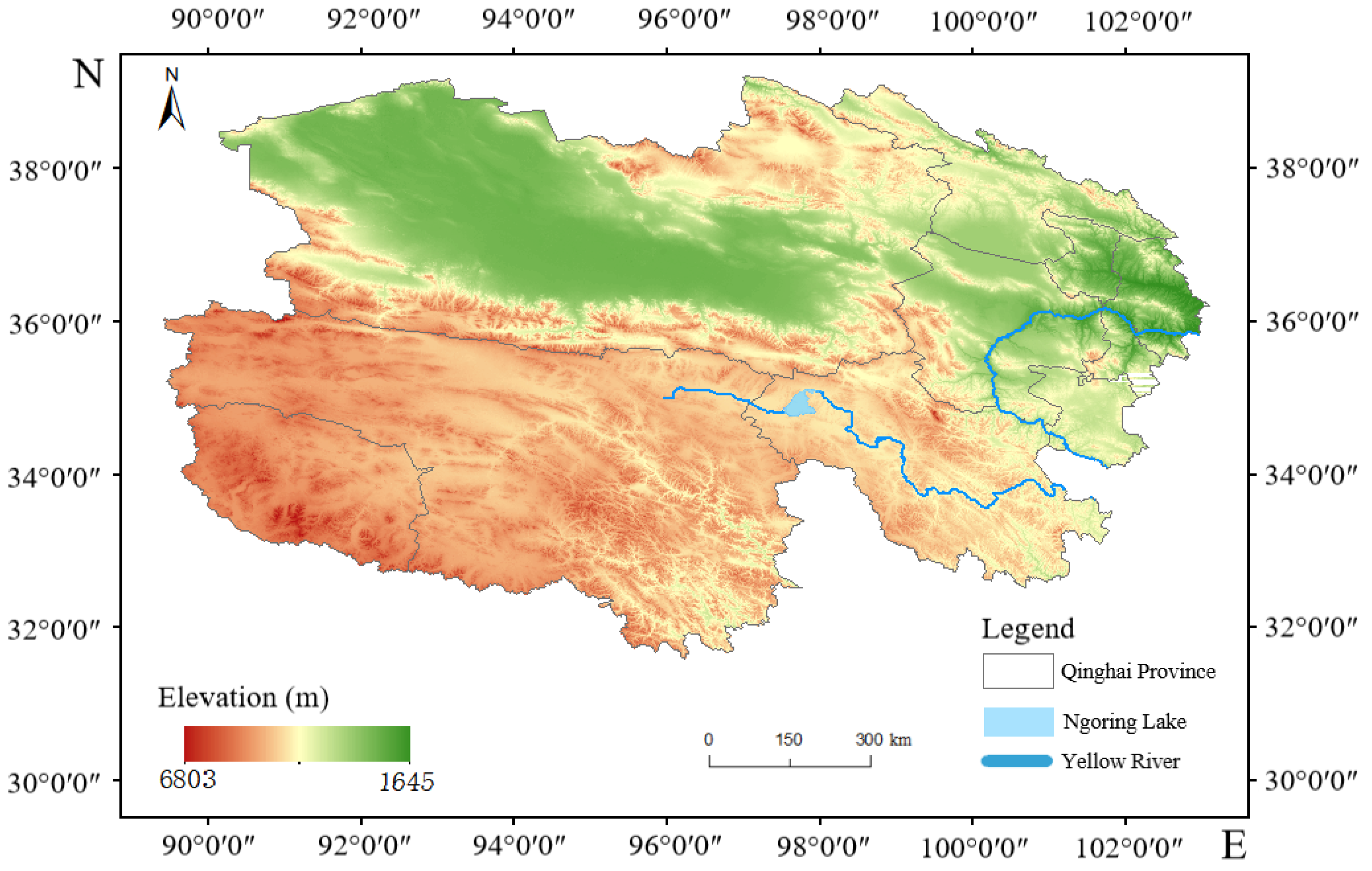
2.1. Study Area
2.2. Data
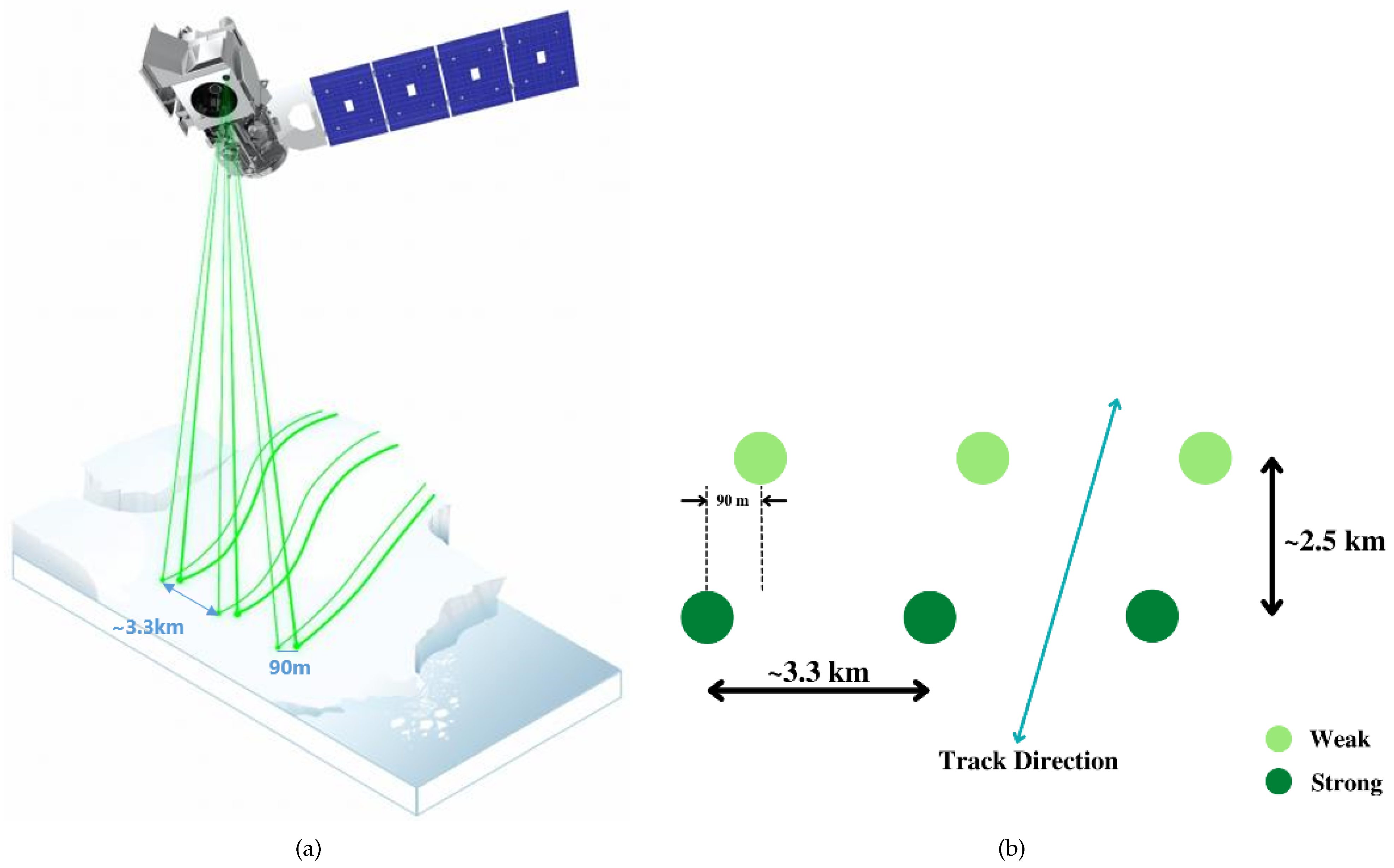
2.2.1. ICESat-2 Laser Altimeter Data
2.2.2. Optical Remote Sensing Image Data
2.2.3. Satellite Altimeter Data
2.3. Methods
2.3.1. ICESat-2 Water Level Extraction and Multisource Altimeter Data Fusion
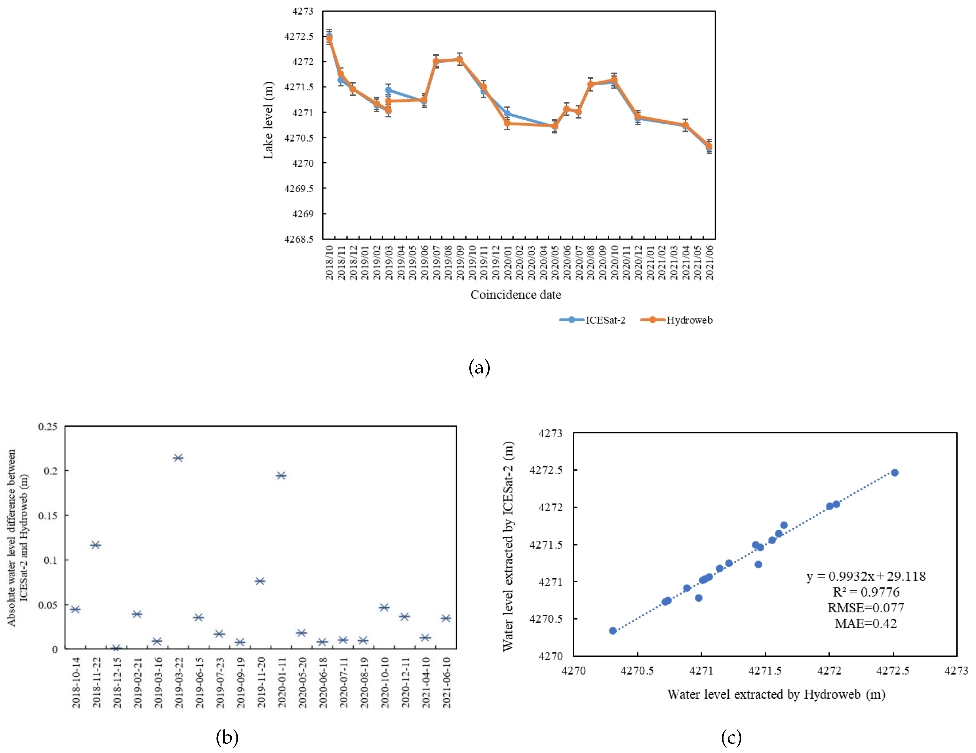
2.3.2. Accuracy Verification and Evaluation of ICESat-2 and Satellite Altimeter
2.3.3. Extraction of Lake Surface Area
2.3.4. Estimation of the Lake Water Storage Based on Water Level—Area Relationship
3. Results
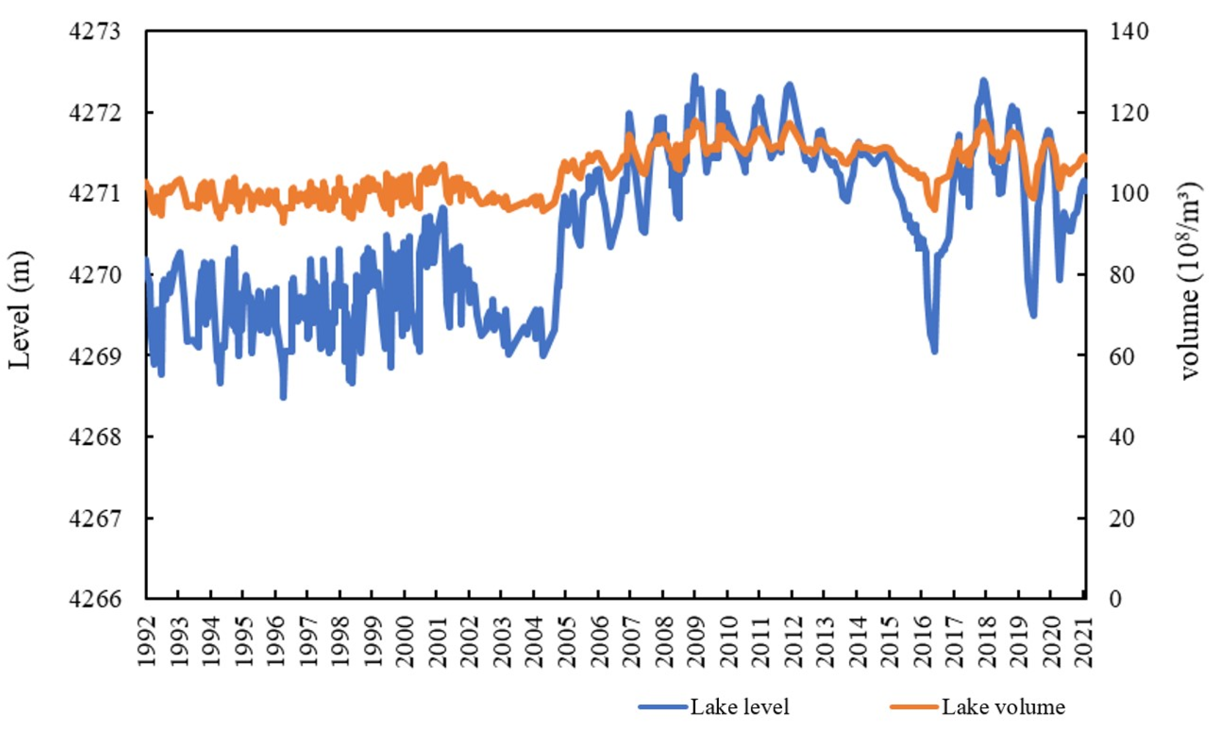
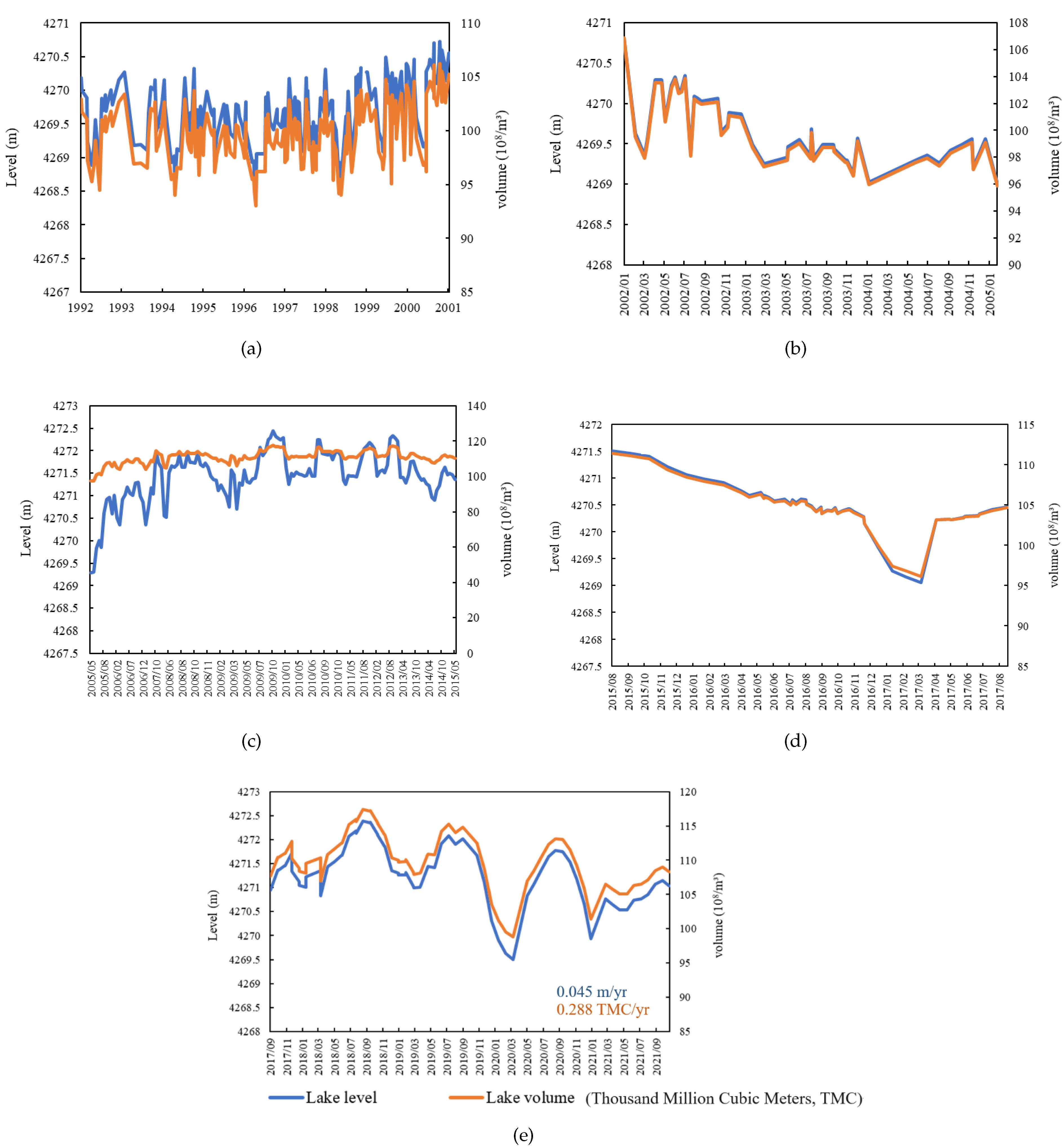
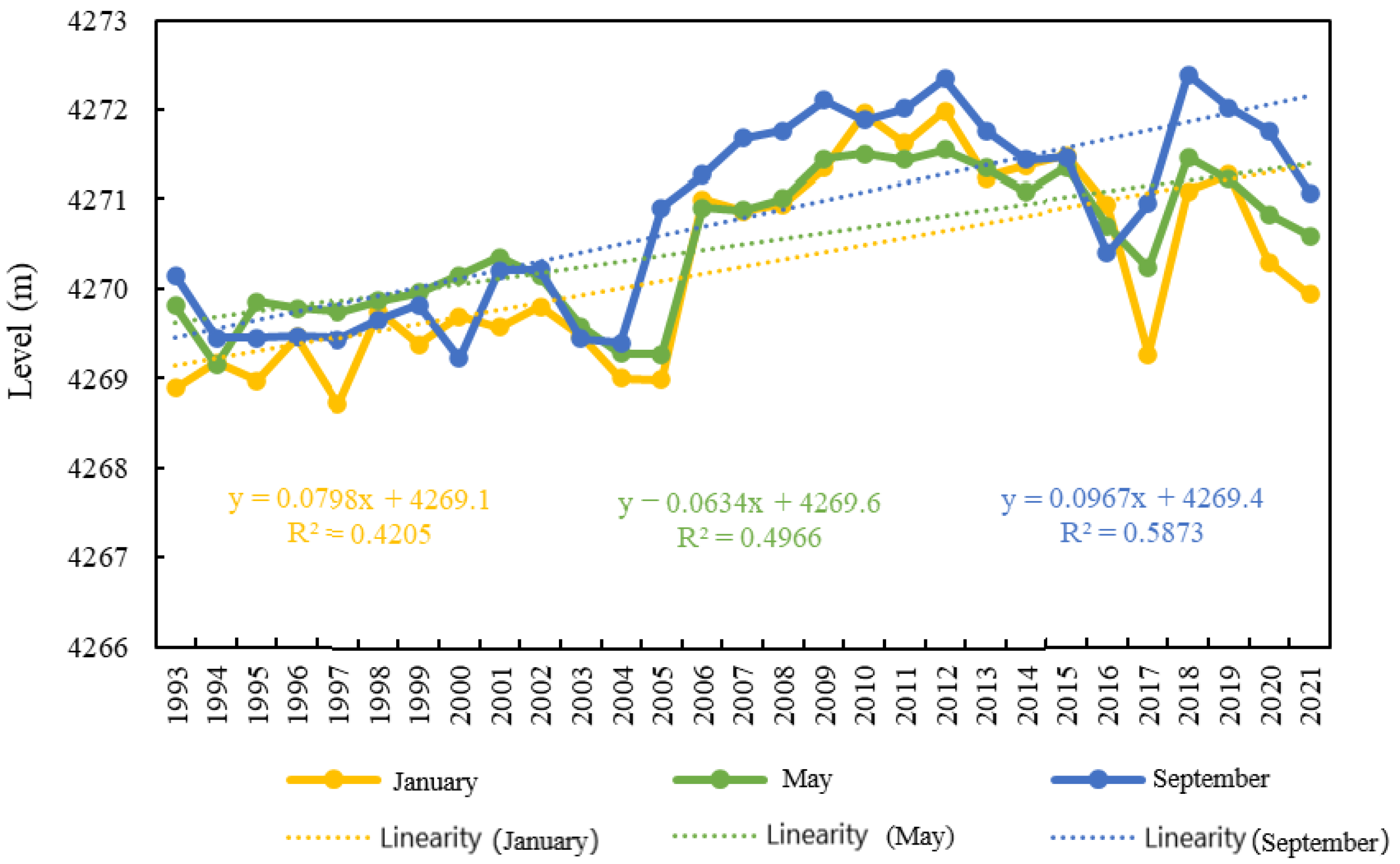
3.1. Analysis of the Changes in Water Level and Water Storage Capacity in Ngoring Lake
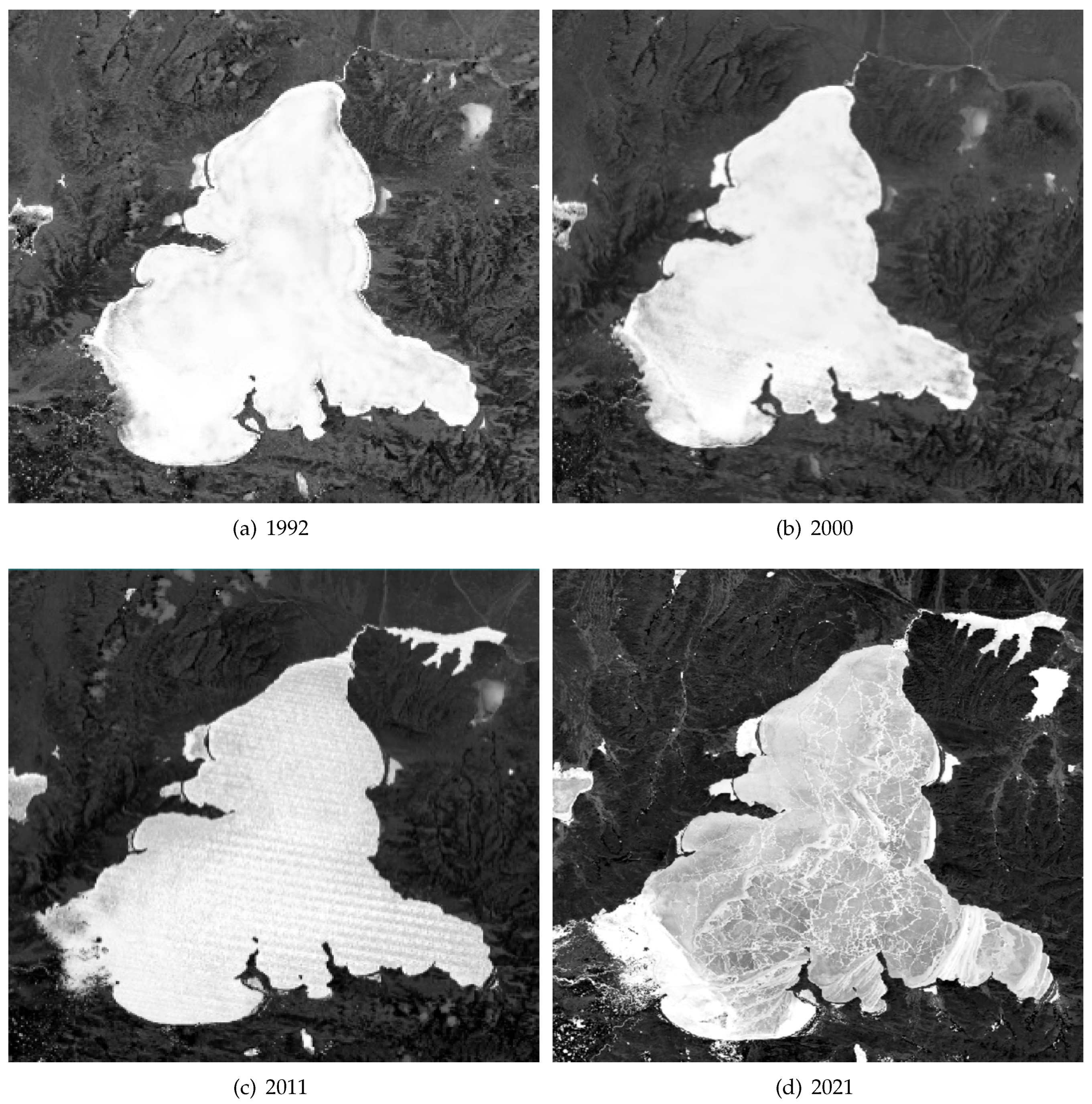
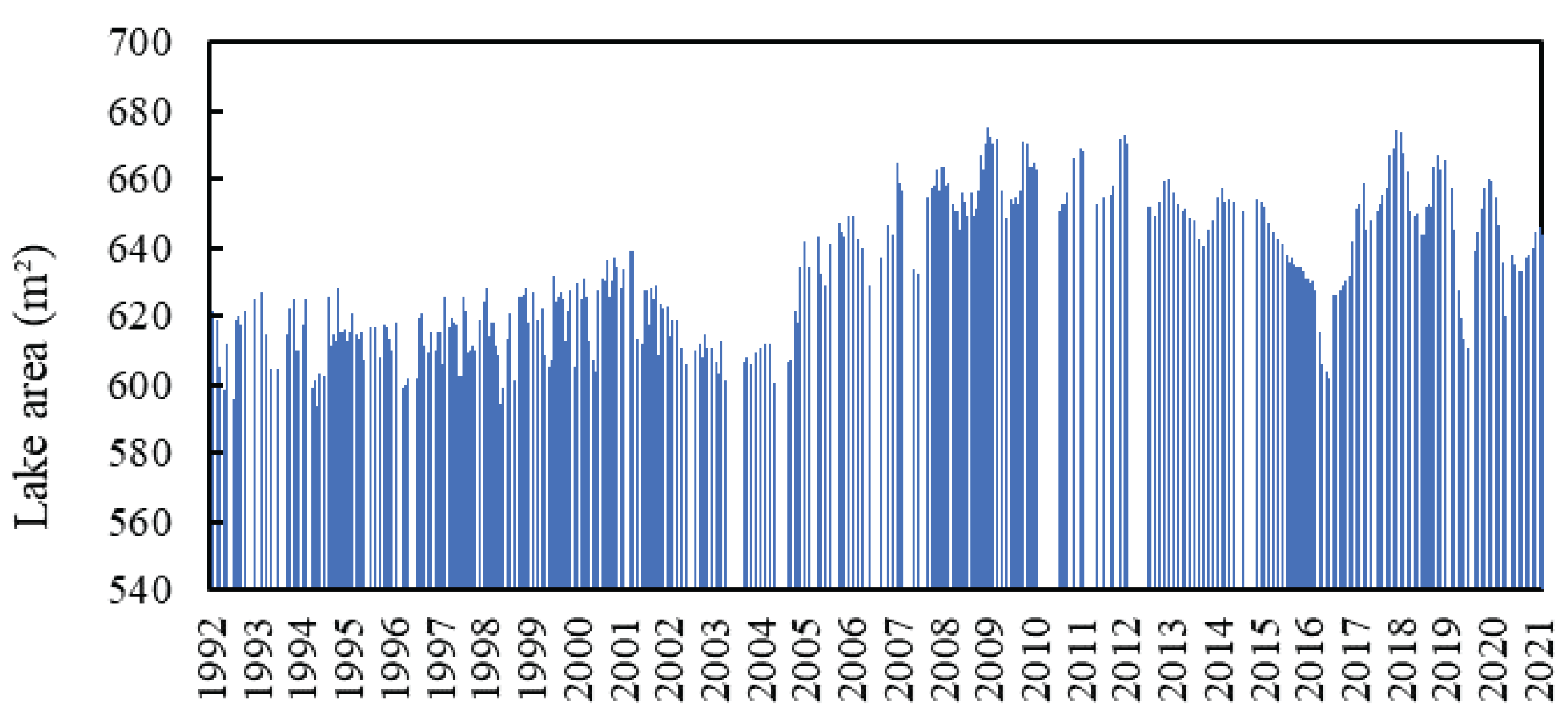
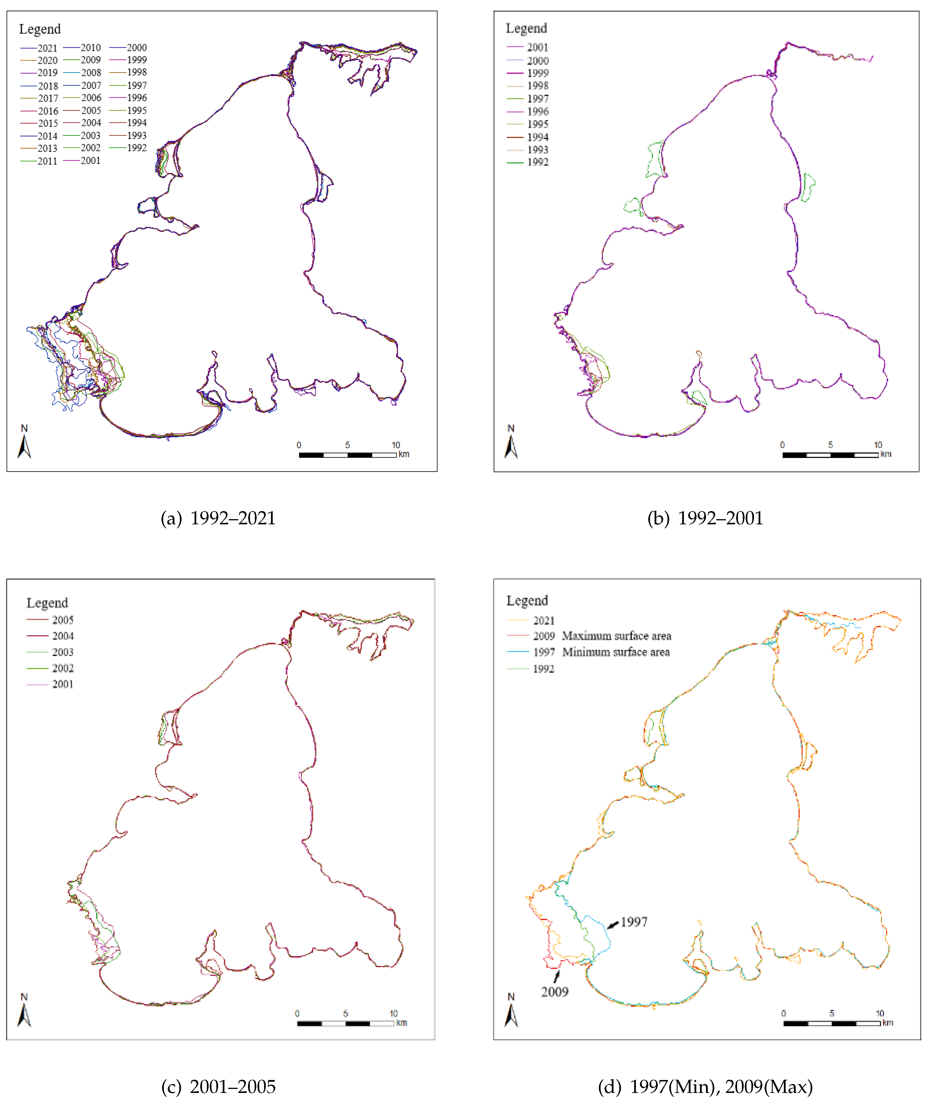
3.2. Changes in Surface Area and Lake Boundary of Ngoring Lake
3.3. Correlation and Attribution Analysis between the Surface Area, Water Level, and Water Storage Changes in Ngoring Lake
3.3.1. Correlation among Surface Area, Water Level, and Water Storage Capacity
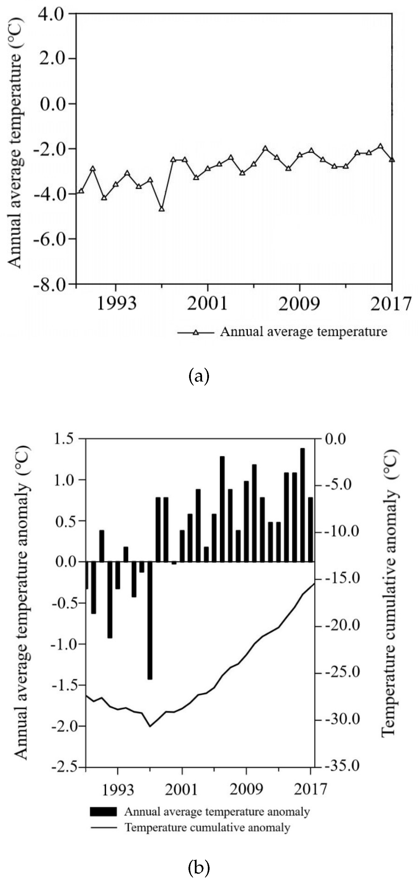
3.3.2. Analysis of the Influence of Meteorological Factors on Water Level
4. Discussion
4.1. Water Level–Water Storage Inversion Error Analysis
4.2. Possible Driving Forces of Lake Changes
5. Conclusions
Author Contributions
Funding
Data Availability Statement
Acknowledgments
Conflicts of Interest
References
- Zisopoulou, K.; Zisopoulos, D.; Panagoulia, D. Water Economics: An In-Depth Analysis of the Connection of Blue Water with Some Primary Level Aspects of Economic Theory I. Water 2022, 14, 103. [Google Scholar] [CrossRef]
- Yang, G.; Ma, R.; Zhang, L.; Jiang, J.; Yao, S.; Zhang, M.; Zeng, H. Lake status, major problems and protection strategy in China. J. Lake Sci. 2010, 22, 799–810. Available online: https://kns.cnki.net/kcms/detail/detail.aspx?FileName=FLKX201006003&DbName=CJFQ2010 (accessed on 1 December 2021).
- Zhu, W.; Yan, J.; Jia, S. Monitoring Recent Fluctuations of the Southern Pool of Lake Chad Using Multiple Remote Sensing Data: Implications for Water Balance Analysis. Remote Sens. 2017, 9, 1032. [Google Scholar] [CrossRef] [Green Version]
- Jiang, J.; Huang, Q. Comparison of Lake distribution characteristics between Qinghai Tibet Plateau and China. Remote Sens. 2004, 6, 24–27. Available online: https://kns.cnki.net/kcms/detail/detail.aspx?FileName=SZYB200406006&DbName=CJFQ2004 (accessed on 1 March 2022).
- Panagoulia, D.; Vlahogianni, E.I. Nonlinear dynamics and recurrence analysis of extreme precipitation for observed and general circulation model generated climates. Hydrol. Process. 2014, 28, 2281–2292. [Google Scholar] [CrossRef]
- Gao, J.; Ma, P.; Du, J.; Huang, X. Spatial distribution of extreme precipitation in the Tibetan Plateau and effects of external forcing factors based on Generalized Pareto Distribution. Water Supply 2020, 21, 1253–1262. [Google Scholar] [CrossRef]
- Wang, W.; Li, H.; Xie, Z.; Zhu, X.; Xiao, L.; Hao, X.; Wang, J. Continental Water Vapor Dominantly Impacts Precipitation during the Snow Season on the Northeastern Tibetan Plateau. J. Clim. 2022, 35, 3819–3831. [Google Scholar] [CrossRef]
- Sun, J.; Yao, X.; Deng, G.; Liu, Y. Characteristics and Synoptic Patterns of Regional Extreme Rainfall over the Central and Eastern Tibetan Plateau in Boreal Summer. Atmosphere 2021, 12, 379. [Google Scholar] [CrossRef]
- Wan, W.; Xiao, P.; Feng, X.; Li, H.; Ma, R.; Duan, H.; Zhao, L. Monitoring lake changes of Qinghai-Tibetan Plateau over the past 30 years using satellite remote sensing data. Chin. Sci. Bull. 2014, 59, 1021–1035. [Google Scholar] [CrossRef]
- Gou, Z.J.; Liu, F.G. Ngoring Lake-Encyclopedia of global change data. J. Glob. Chang. Data Discov. 2019, 3, 91–92. [Google Scholar]
- Zhang, G.; Chen, W.; Xie, H. Tibetan plateau’s lake level and volume changes from NASA’s ICESat/ICESat-2 and landsat missions. Geophys. Res. Lett. 2019, 46, 13107–13118. [Google Scholar] [CrossRef]
- Cai, W.; Yu, J.Q.; Li, H.J. Application and Prospect of Remote Sensing Techniques to Lake Environmental Monitoring. J. Salt Lake Res. 2005, 4, 14–20. Available online: https://kns.cnki.net/kcms/detail/detail.aspx?FileName=YHYJ200504003&DbName=CJFQ2005 (accessed on 1 January 2022).
- Zhao, Y.; Liao, J.J.; Shen, G.Z.; Zhang, X.L. Monitoring the water level changes in Qinghai Lake with satellite altimetry data. J. Remote. Sens. 2017, 21, 633–644. [Google Scholar] [CrossRef]
- Tian, Y.; Zhang, X.Q.; Sun, R. Extracting Alpine Lake Information Based on Multi-Source and Multi-Temporal Satellite Images and Its Uncertainty Analysis—A Case Study in Yamzhog Yumco Basin, South Tibet. J. Glaciol. Geocryol. 2012, 34, 563–572. Available online: https://kns.cnki.net/kcms/detail/detail.aspx?FileName=BCDT201203008&DbName=CJFQ2012 (accessed on 1 March 2021).
- Jiang, W.P.; Chu, Y.H.; Li, J.C.; Yao, Y.S. Water Level Variation of Qinghai Lake from Altimeteric Data. Geomat. Inf. Sci. Wuhan Univ. 2008, 1, 64–67. Available online: https://kns.cnki.net/kcms/detail/detail.aspx?FileName=WHCH200801015&DbName=CJFQ2008 (accessed on 1 January 2022).
- Arsen, A.; Crétaux, J.-F.; Berge-Nguyen, M.; Del Rio, R.A. Remote sensing-derived bathymetry of lake poopo. Remote Sens. 2014, 6, 407–420. [Google Scholar] [CrossRef] [Green Version]
- Dubey, A.K.; Gupta, P.K.; Dutta, S.; Singh, R.P. An improved methodology to estimate river stage and discharge using jason-2 satellite data. J. Hydrol. 2015, 529, 1776–1787. [Google Scholar] [CrossRef]
- Policelli, F.; Hubbard, A.; Jung, H.C.; Zaitchik, B.; Ichoku, C. A predictive model for Lake Chad total surface water area using remotely sensed and modeled hydrological and meteorological parameters and multivariate regression analysis. J. Hydrol. 2019, 568, 1071–1080. [Google Scholar] [CrossRef]
- Wang, J.; Li, M.; Wang, L.; She, J.; Zhu, L.; Li, X. Long-term lake area change and its relationship with climate in the endorheic basins of the tibetan plateau. Remote Sens. 2021, 13, 5125. [Google Scholar] [CrossRef]
- Qiao, B.; Zhu, L.; Wang, J.; Ju, J.; Ma, Q.; Liu, C. Estimation of lakes water storage and their changes on the northwestern Tibetan Plateau based on bathymetric and Landsat data and driving force analyses. Quat. Int. 2017, 454, 56–67. [Google Scholar] [CrossRef]
- Wang, L.M.; Wang, J.X.; Wang, L.C.; Zhu, L.P.; Li, X.G. Terrestrial water storage regime and its change in the endorheic Tibetan Plateau. Sci. Total. Environ. 2022, 815, 152729. [Google Scholar] [CrossRef] [PubMed]
- Qiao, B.; Zhu, L.; Wang, J.; Ju, J.; Ma, Q.; Huang, L.; Chen, H.; Liu, C.; Xu, T. Estimation of lake water storage and changes based on bathymetric data and altimetry data and the association with climate change in the central Tibetan Plateau. J. Hydrol. 2019, 578, 124052. [Google Scholar] [CrossRef]
- Wang, S.M.A.; Dou, H.S. Lake Records of China; Science Press: Beijing, China, 1998; pp. 1–580. [Google Scholar]
- Li, W.S.; Feng, L.; Sun, S.L. Influence of Zaling and Eling Lake on the Annual Discharge of the Huanghe River Source Area. Acta Geogr. Sin. 2001, 56, 75–82. Available online: https://kns.cnki.net/kcms/detail/detail.aspx?FileName=DLXB200101008&DbName=CJFQ2001 (accessed on 1 May 2021).
- Compilation Committee of Maduo County Chronicles. Maduo County Chronicle; Qinghai Ethnic Publishing House: Madoi County, China, 2011; pp. 182–195. [Google Scholar]
- Du, J.; Wen, L.J.; Su, D.S. Analysis of Simulated Temperature Difference between Lake Surface and Air and Energy Balance of Three Alpine Lakes with Different Depths on the Qinghai-Xizang Plateau during the Ice-Free Period. Plateau Meteorol. 2020, 39, 1181–1194. Available online: https://kns.cnki.net/kcms/detail/detail.aspx?FileName=GYQX202006005&DbName=CJFQ2020 (accessed on 1 May 2021).
- Magruder, L.A.; Brunt, K.M. Performance Analysis of Airborne Photon-Counting Lidar Data in Preparation for the ICESat-2 Mission. IEEE Trans. Geosci. Remote. Sens. 2018, 56, 2911–2918. [Google Scholar] [CrossRef]
- Neuenschwander, A.; Pitts, K. The ATL08 land and vegetation product for the ICESat-2 Mission. Remote. Sens. Environ. 2019, 221, 247–259. [Google Scholar] [CrossRef]
- Zhu, X.X.; Wang, C.; Xi, X.H.; Nie, S.; Yang, X.B.; Li, D. ICESat-2/ATLAS Data Processing and Applications: A Review. Infrared Laser Eng. 2020, 49, 76–85. Available online: https://kns.cnki.net/kcms/detail/detail.aspx?FileName=HWYJ202011008&DbName=DKFX2020 (accessed on 1 January 2022).
- Xu, N.; Zheng, H.; Ma, Y.; Yang, J.; Liu, X.; Wang, X. Global estimation and assessment of monthly Lake/Reservoir water level changes using ICESat-2 ATL13 products. Remote Sens. 2021, 13, 2744. [Google Scholar]
- Jiang, G.Z.; Han, B.; Gao, Y.B.; Yang, C.J. Review of 40-year earth observation with Landsat series and prospects of LDCM. J. Remote Sens. 2013, 17, 1033–1048. Available online: https://kns.cnki.net/kcms/detail/detail.aspx?FileName=YGXB201305001&DbName=CJFQ2013 (accessed on 1 September 2021).
- Xu, H.Q. Change of Landsat 8 TIRS calibration parameters and its effect on land surface temperature retrieval. J. Remote. Sens. 2016, 20, 229–235. [Google Scholar] [CrossRef]
- Wang, D.Z.; Wang, S.M.; Huang, C. Comparison of Sentinel-2 imagery with Landsat8 imagery for surface water extraction using four common water indexes. J. Remote. Sens. 2019, 31, 157–165. Available online: https://kns.cnki.net/kcms/detail/detail.aspx?FileName=GTYG201903020&DbName=CJFQ2019 (accessed on 1 September 2021).
- Yue, H.; Liu, Y.; Wei, J. Dynamic change and spatial analysis of great lakes in china based on hydroweb and landsat data. Arab. J. Geosci. 2021, 14, 149. [Google Scholar] [CrossRef]
- Muala, E.; Mohamed, Y.A.; Duan, Z.; Zaag, P.V. Estimation of reservoir discharges from lake nasser and roseires reservoir in the nile basin using satellite altimetry and imagery data. Remote. Sens. 2014, 6, 7522–7545. [Google Scholar] [CrossRef] [Green Version]
- Sun, W.; Jin, J.W.; Li, G.Y.; Me, J.Q. Accuracy evaluation of laser altimetry satellite ICESa1-2 in monitoring water level of Taihu lake. Sci. Surv. Mapp. 2021, 46, 6–11. Available online: https://kns.cnki.net/kcms/detail/detail.aspx?FileName=CHKD202111002&DbName=DKFX2021 (accessed on 1 February 2022).
- Zhang, J.T.; Liu, C.L. Water level change monitoring of Danjiangkou reservoir based on laser altimetry data. Sci. Surv. Mapp. 2021, 46, 20–24. Available online: https://kns.cnki.net/kcms/detail/detail.aspx?FileName=CHKD202102004&DbName=DKFX2021 (accessed on 1 December 2021).
- Wu, H.B.; Guo, Z.M.; Mao, R.J. Monitoring Lake Water Level Changes in the Middle and Lower Yangtze River Basin Based on ICESat-GLAS Altimetry Data. Resour. Sci. 2012, 34, 2289–2298. Available online: https://kns.cnki.net/kcms/detail/detail.aspx?FileName=ZRZY201212012&DbName=CJFQ2012 (accessed on 1 February 2022).
- Dandabathula, G.; Rao, S.S. Validation of ICESat-2 Surface Water Level Product ATL13 with Near Real Time Gauge Data. Hydrology 2020, 8, 19–25. [Google Scholar] [CrossRef]
- Sun, F.; Ma, R.; He, B.; Zhao, X.; Zeng, Y.; Zhang, S.; Tang, S. Changing patterns of lakes on the southern tibetan plateau based on multi-source satellite data. Remote. Sens. 2020, 12, 3450. [Google Scholar] [CrossRef]
- Xu, H.Q. A Study on Information Extraction of Water Body with the Modified Nomalized Difference Water Index (MNDWI). J. Remote. Sens. 2005, 5, 589–595. Available online: https://kns.cnki.net/kcms/detail/detail.aspx?FileName=YGXB200505011&DbName=CJFQ2005 (accessed on 1 December 2021).
- Xu, R.; Zhang, Z.X.; Zhao, C.Z. Different Models Used in Extraction of Lake Water Body Based on MODIS Data. Remote. Sens. Inf. 2015, 30, 111–118. Available online: https://kns.cnki.net/kcms/detail/detail.aspx?FileName=YGXX201501019&DbName=CJFQ2015 (accessed on 1 February 2022).
- Lu, S.J.; Zhou, Q.P.; Wang, Y.J.; Zeng, H. Comprehensive Evaluation of Water Environment in the Eling Lake Area. J. Environ. Health 2007, 30, 598–599. Available online: https://kns.cnki.net/kcms/detail/detail.aspx?FileName=HJYJ200708015&DbName=CJFQ2007 (accessed on 1 February 2022).
- Sun, J.Y.; Yuan, L.; Wang, X.S.; Li, P.Z.; Zou, J.Q. Correlations between water surface area, water storage, and water level of Danjiangkou Reservoir based on GF_l Satellite. South–North Water Transf. Water Sci. Technol. 2017, 15, 89–96. Available online: https://kns.cnki.net/kcms/detail/detail.aspx?FileName=NSBD201705014&DbName=CJFQ2017 (accessed on 1 March 2022).
- Song, C.; Huang, B.; Ke, L. Modeling and analysis of lake water storage changes on the tibetan plateau using multi-mission satellite data. Remote Sens. Environ. 2013, 135, 25–35. [Google Scholar] [CrossRef]
- Taube, C.M. Instructions for Winter Lake Mapping//Schneider J C. Manual of Fisheries Survey Methods II: With Periodic Updates; Michigan Department of Natural Resources: Ann Arbor, MI, USA, 2000; pp. 50–52.
- Li, Z.G.; Lv, S.H.; Ao, Y.H.; Wang, S.Y. Analysis of Micrometeorology and CO2 Flux Characteristics over Lake Ngoring Lakeside Region in Summer. Prog. Geogr. 2012, 31, 602–608. Available online: https://kns.cnki.net/kcms/detail/detail.aspx?FileName=DLKJ201205011&DbName=CJFQ2012 (accessed on 1 December 2021).
- Hao, A.; Duan, H.; Wang, X.; Zhao, G.; You, Q.; Peng, F.; Du, H.; Liu, F.; Li, C.; Lai, C.; et al. Different response of alpine meadow and alpine steppe to climatic and anthropogenic disturbance on the Qinghai-Tibetan Plateau. Glob. Ecol. Conserv. 2021, 27, e01512. [Google Scholar] [CrossRef]
- Zhang, B.; Qin, Q.M.; Sun, Y.J.; Zhang, Z.X.; You, L. Dynamic monitoring and change analysis of Gyarng Lake and Ngoring Lake of recent 30 years based on remote sensing method. Sci. Surv. Mapp. 2010, 35, 54–56. Available online: https://kns.cnki.net/kcms/detail/detail.aspx?FileName=CHKD201004018&DbName=CJFQ2010 (accessed on 1 February 2022).
- Wang, Y.; Li, Y.H.; Sun, X.Y. Impact of climate change on the eco-environment in the Yellow River Source. Pratacultural Sci. 2015, 32, 539–551. Available online: https://kns.cnki.net/kcms/detail/detail.aspx?FileName=CYKX201504008&DbName=CJFQ2015 (accessed on 1 February 2022).
- Feng, X.L.; Liu, C.H.; Lin, P.F.; Bai, W.R.; Yu, D. Multi-Timescale Features of Surface Air Temperature in the Source Region of the Yellow River during 1953–2017. Climatic and Environmental Research. Clim. Environ. Res. 2020, 25, 333–344. (In Chinese). Available online: https://kns.cnki.net/kcms/detail/detail.aspx?FileName=QHYH202003009&DbName=CJFQ2020 (accessed on 1 February 2022).
- Xie, J.K. Influences of Climatic Variability and Human Activitics on Terrestrial Water Storage Variations Across the Yellow River Basin. Zhejiang University, Zhejiang, China. 2020. Available online: https://kns.cnki.net/kcms/detail/detail.aspx?FileName=1020085115.nh&DbName=CDFD2021 (accessed on 1 February 2022).
- Luo, S.; Song, C.; Zhan, P.; Liu, K.; Chen, T.; Li, W.; Ke, L. Refined estimation of lake water level and storage changes on the Tibetan Plateau from ICESat/ICESat-2. Catena 2021, 200, 105177. [Google Scholar] [CrossRef]
- Lei, Y.; Zhu, Y.; Wang, B.; Yao, T.; Yang, K.; Zhang, X.; Zhai, J.; Ma, N. Extreme lake level changes on the Tibetan plateau associated with the 2015/2016 El Nino. Geophys. Res. Lett. 2019, 46, 5889–5898. [Google Scholar] [CrossRef]
- Song, C.; Ye, Q.; Sheng, Y.; Gong, T. Combined ICESat and CryoSat-2 altimetry for accessing water level dynamics of Tibetan lakes over 2003–2014. Water 2015, 7, 4685–4700. [Google Scholar] [CrossRef] [Green Version]
- Zhang, G.; Yao, T.; Xie, H.; Yang, K.; Zhu, L.; Shum, C.; Bolch, T.; Yi, S.; Allen, S.; Jiang, L.; et al. Response of Tibetan Plateau’s lakes to climate changes: Trend, pattern, and mechanisms. Earth-Sci. Rev. 2020, 208, 103269. [Google Scholar] [CrossRef]


| Track Number | Observation Date |
|---|---|
| ID 248 | 14/10/2018; 14/07/2019; 11/01/2020; 11/07/2020; 10/10/2020; 10/04/2021; |
| ID 393 | 23/07/2019; 21/01/2020; |
| ID 690 | 12/08/2019; 07/02/2021; |
| ID 835 | 22/11/2018; 21/02/2019; 22/05/2019; 20/11/2019; 19/02/2020; 20/05/2020; 19/08/2020; 17/11/2020; 16/02/2021; |
| ID 1193 | 15/12/2018; 16/03/2019; 15/06/2019; 12/06/2020; 11/12/2020; 10/06/2021; |
| ID 1277 | 22/03/2019; 19/09/2019; 18/06/2020; 16/12/2020; |
| Satellite Name | Observation Time | Track Number | Quantity |
|---|---|---|---|
| Landsat-5 TM | 1992–2011 | 134_36 | 60 |
| Landsat-7 ETM+ | 1999–2002 | 134_36 | 17 |
| Landsat-8 OLI | 2013–2021 | 134_36 | 38 |
| Sentinel-2 A | 2021.01–2021.11 | N0301_R090 | 8 |
| Sentinel-2 B | 2021.01–2021.11 | N0301_R090 | 12 |
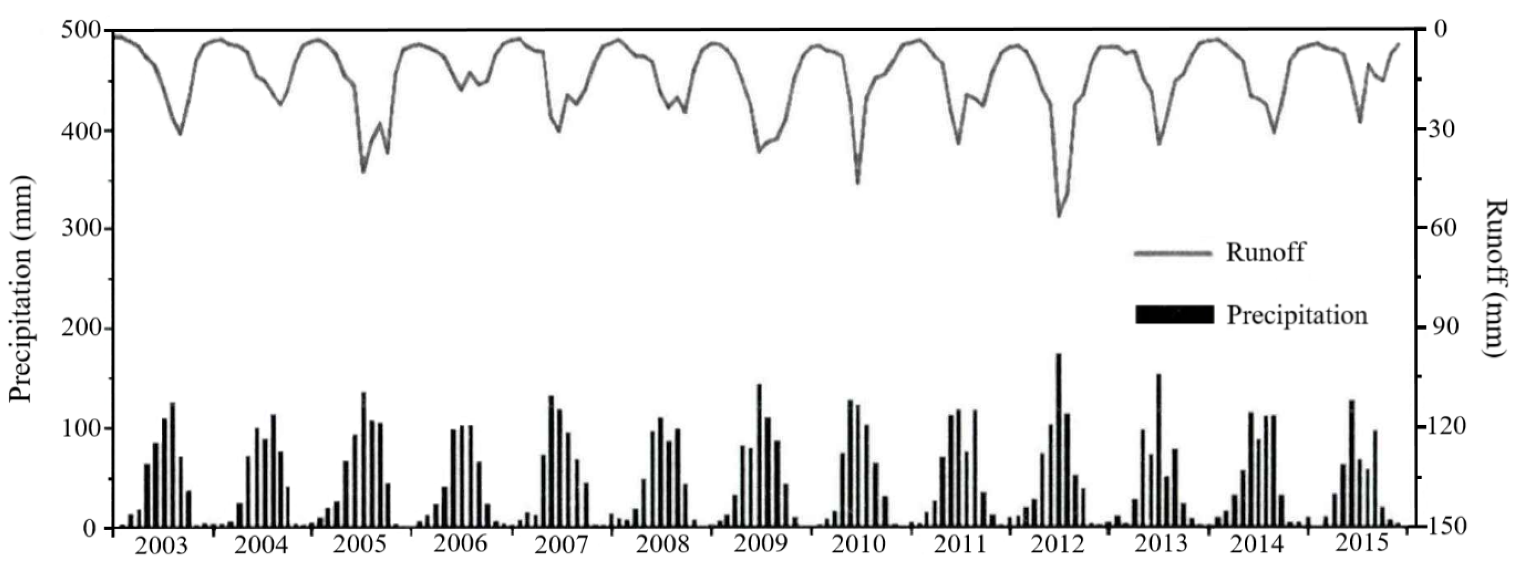
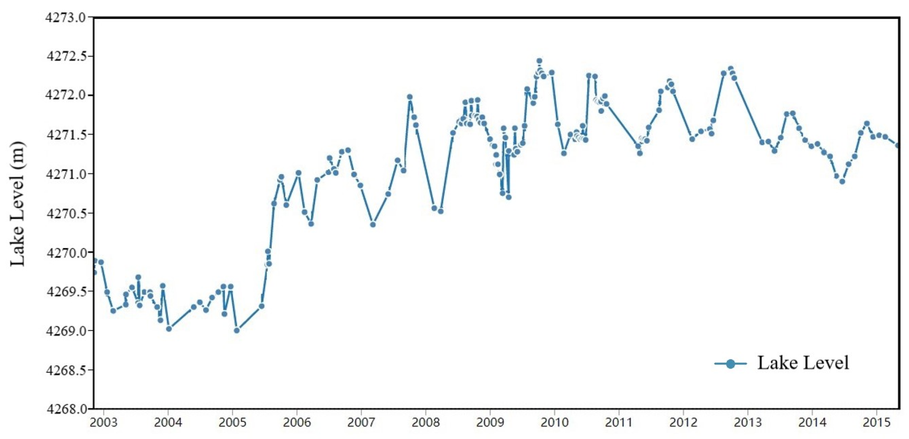
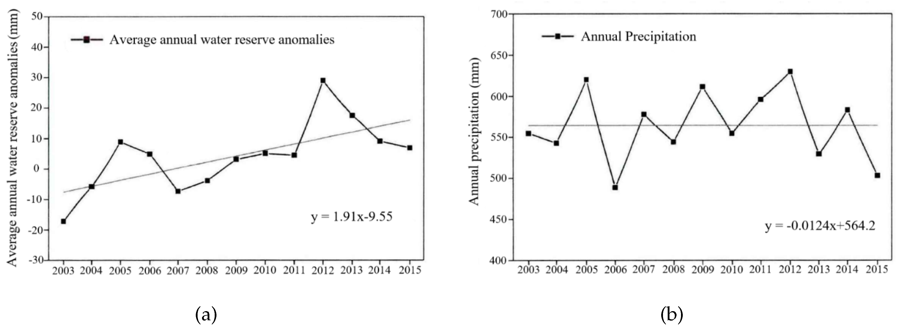
| Year | Annual Average Water Reserve Anomaly | Annual Average Temperature | Annual Precipitation | Annual Average Water Level |
|---|---|---|---|---|
| 2003 | −18.4 mm | −2.51 °C | 552 mm | 4269.39 m |
| 2004 | −6.1 mm | −3.12 °C | 541 mm | 4269.34 m |
| 2005 | 9.2 mm | −2.94 °C | 628 mm | 4269.62 m |
| 2006 | 5.6 mm | −2.14 °C | 483 mm | 4270.94 m |
| 2007 | −7.5 mm | −2.53 °C | 578 mm | 4271.12 m |
| 2008 | −4.8 mm | −3.06 °C | 542 mm | 4271.40 m |
| 2009 | 4.6 mm | −2.41 °C | 619 mm | 4271.68 m |
| 2010 | 5.2 mm | −2.21 °C | 551 mm | 4271.69 m |
| 2011 | 4.9 mm | −2.62 °C | 596 mm | 4271.72 m |
| 2012 | 29.6 mm | −2.93 °C | 632 mm | 4271.84 m |
| 2013 | 18.2 mm | −2.91 °C | 530 mm | 4271.49 m |
Publisher’s Note: MDPI stays neutral with regard to jurisdictional claims in published maps and institutional affiliations. |
© 2022 by the authors. Licensee MDPI, Basel, Switzerland. This article is an open access article distributed under the terms and conditions of the Creative Commons Attribution (CC BY) license (https://creativecommons.org/licenses/by/4.0/).
Share and Cite
Zhu, W.; Zhao, S.; Qiu, Z.; He, N.; Li, Y.; Zou, Z.; Yang, F. Monitoring and Analysis of Water Level–Water Storage Capacity Changes in Ngoring Lake Based on Multisource Remote Sensing Data. Water 2022, 14, 2272. https://doi.org/10.3390/w14142272
Zhu W, Zhao S, Qiu Z, He N, Li Y, Zou Z, Yang F. Monitoring and Analysis of Water Level–Water Storage Capacity Changes in Ngoring Lake Based on Multisource Remote Sensing Data. Water. 2022; 14(14):2272. https://doi.org/10.3390/w14142272
Chicago/Turabian StyleZhu, Weidong, Shubing Zhao, Zhenge Qiu, Naiying He, Yaqin Li, Ziya Zou, and Fei Yang. 2022. "Monitoring and Analysis of Water Level–Water Storage Capacity Changes in Ngoring Lake Based on Multisource Remote Sensing Data" Water 14, no. 14: 2272. https://doi.org/10.3390/w14142272