
Assessing Groundwater Dynamics and Potentiality in the Lower Ganga Plain, India

 ,
, 
 , , , and
Abstract
:1. Introduction
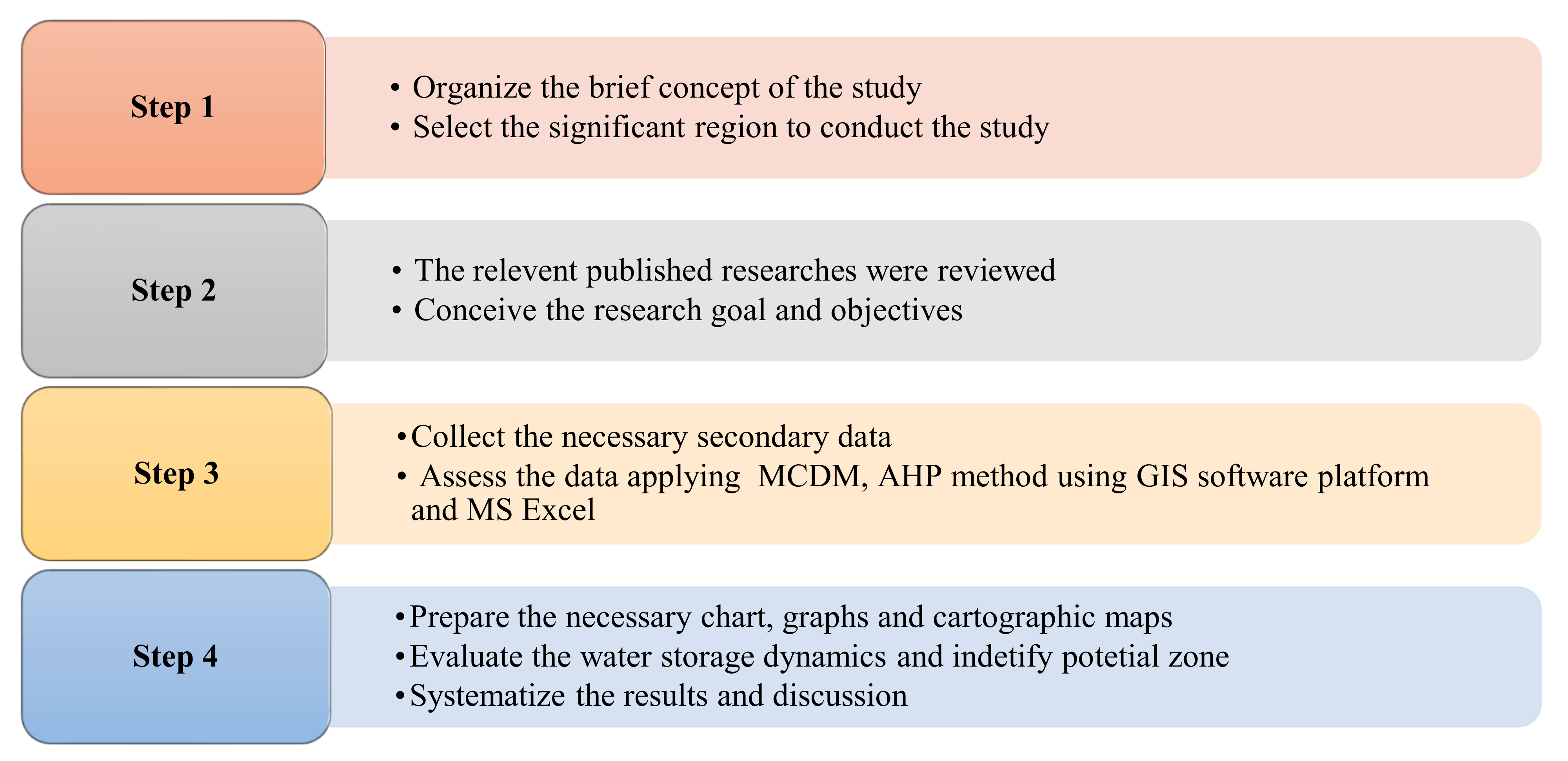
2. Material and Methods
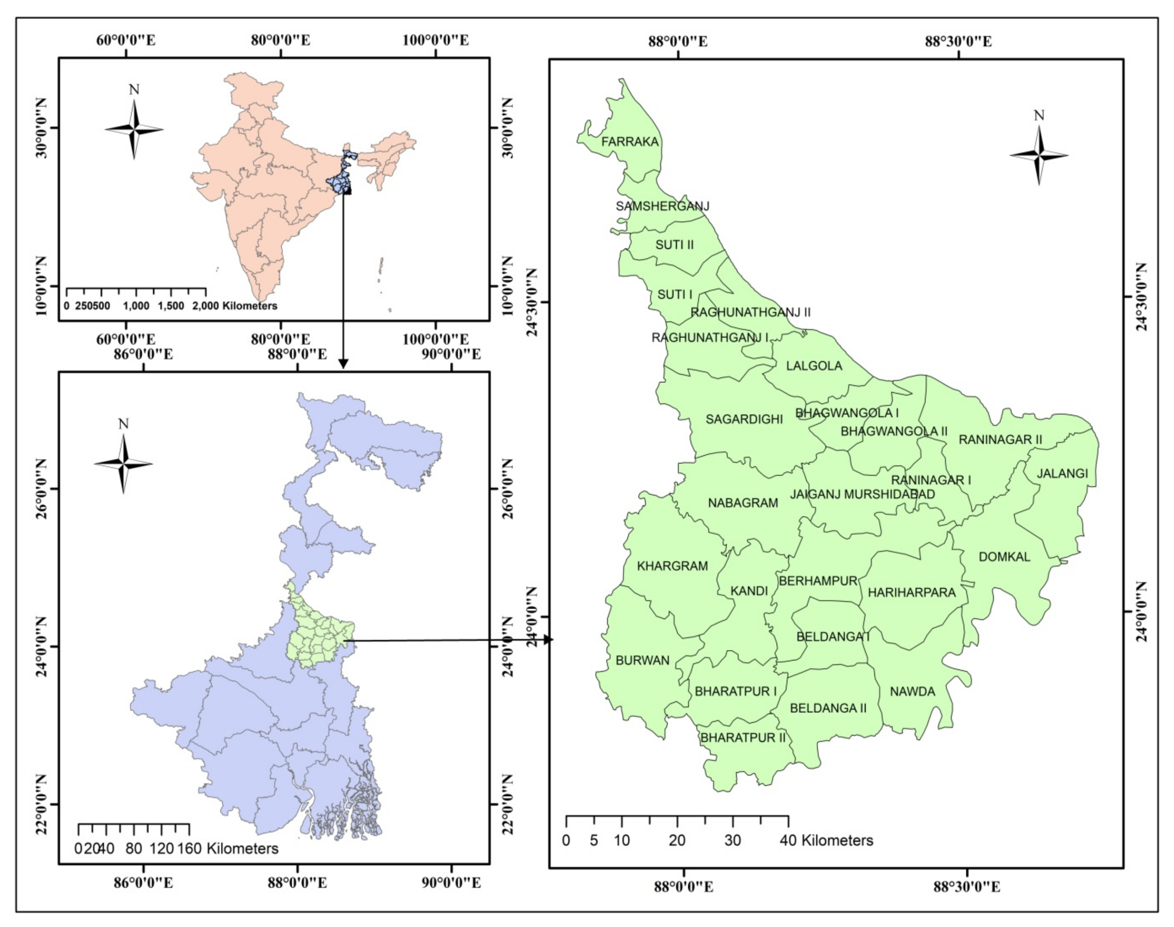
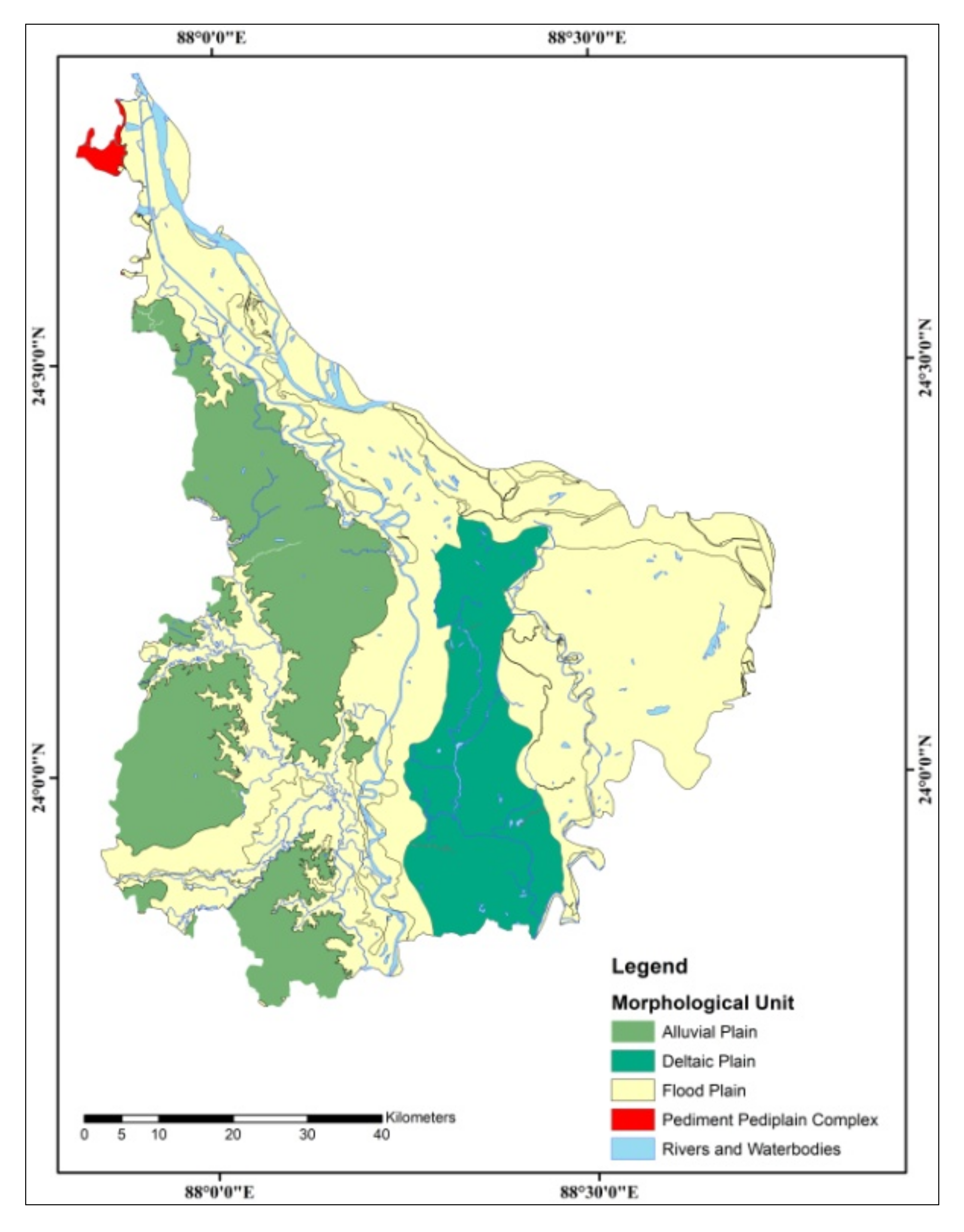
2.1. Study Area
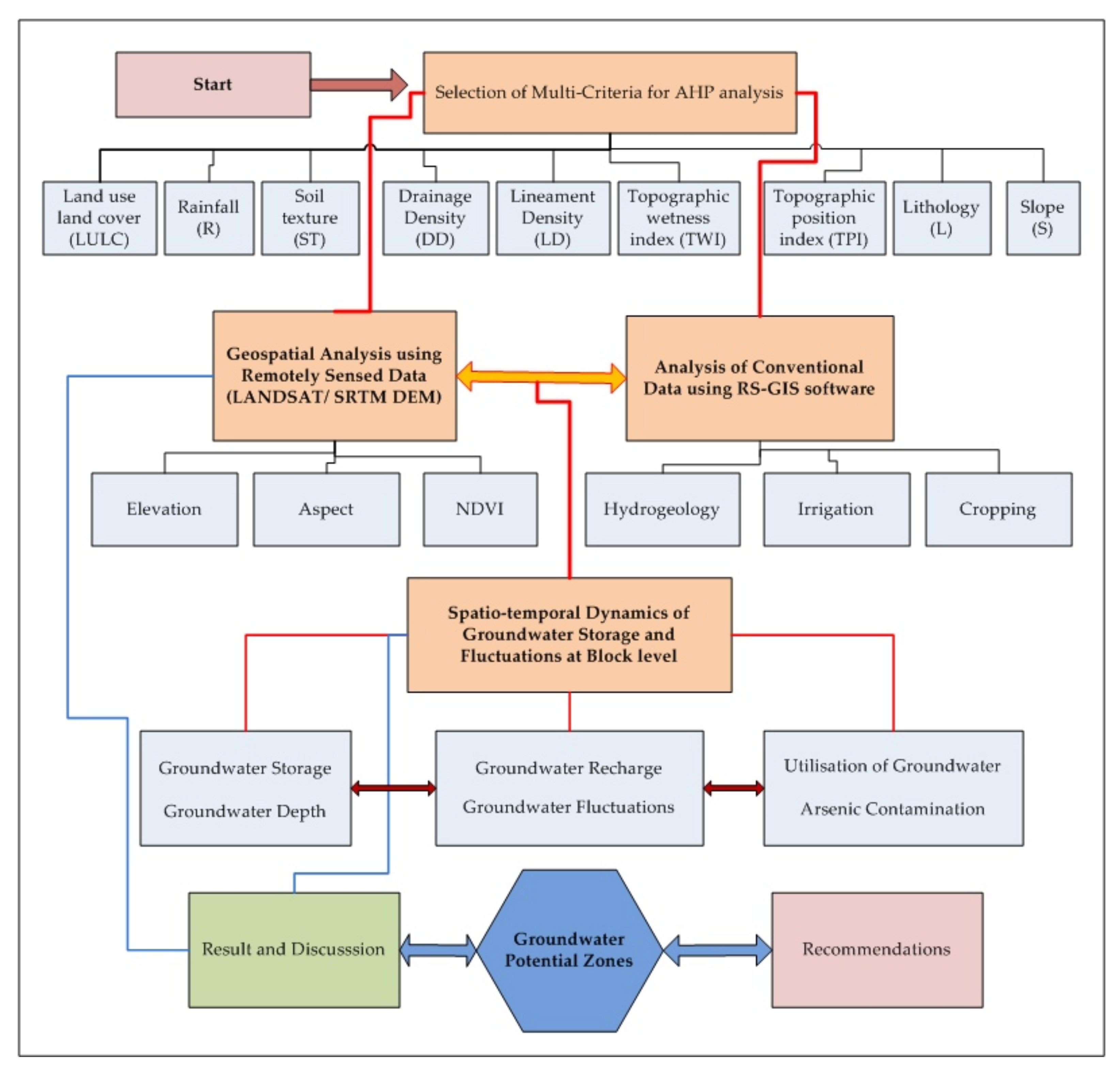
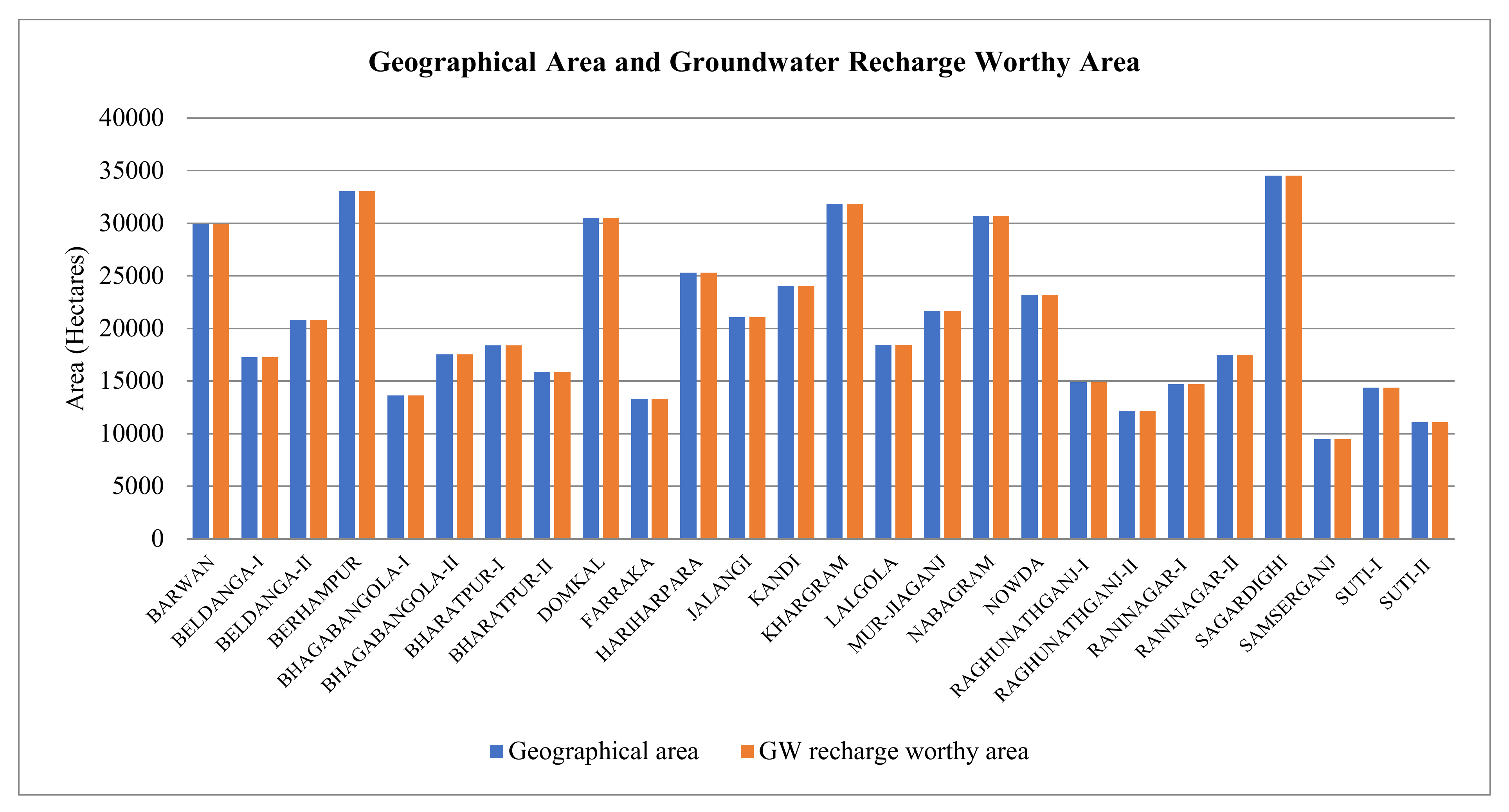
2.2. Database and Analysis
2.3. Applied Methodology
- 1st Step is to construct the pairwise contrast between each criteria (Table 3). This comparison describes an integer value ranging from 1 (equally preferred) to 9 (extremely preferred), and the higher value signifies that the chosen criteria is considered to be more imperative, with superior implications.
- 2nd Step is carrying out the matrix.
- 3rd Step is normalization and determination of weight of each criteria.
- 4th Step is calculating the Consistency Ratio (CR) (Table 4). This is calculated by the equation: CR = Consistency Index (CI)/Random Index (RI)
2.4. Significant Contributing Factors and Multi-Criteria Analysis of Groundwater
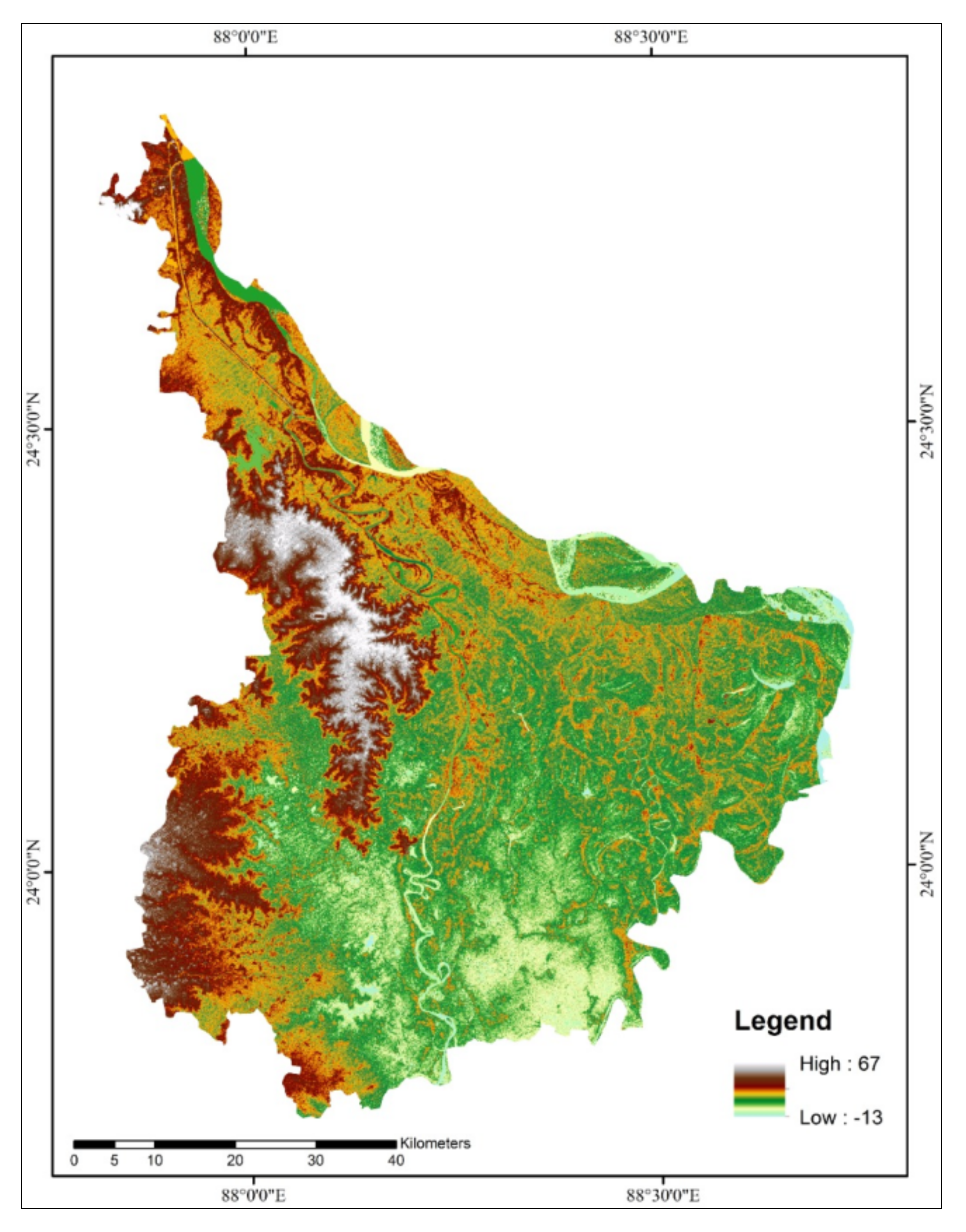
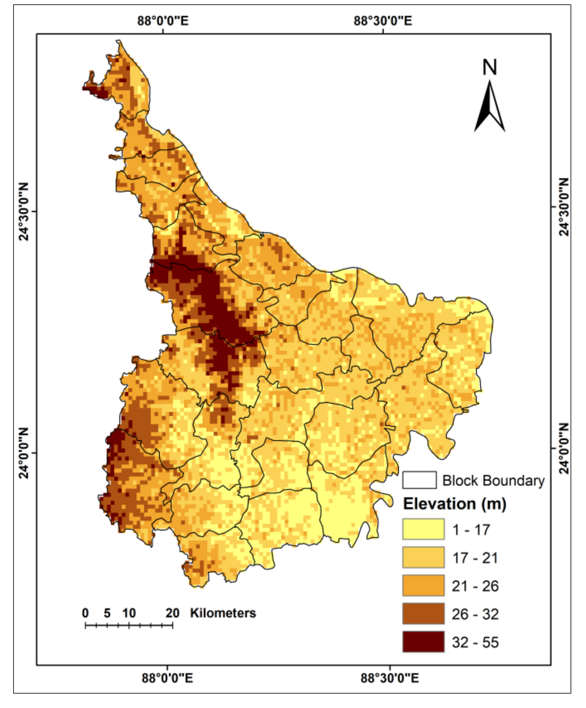
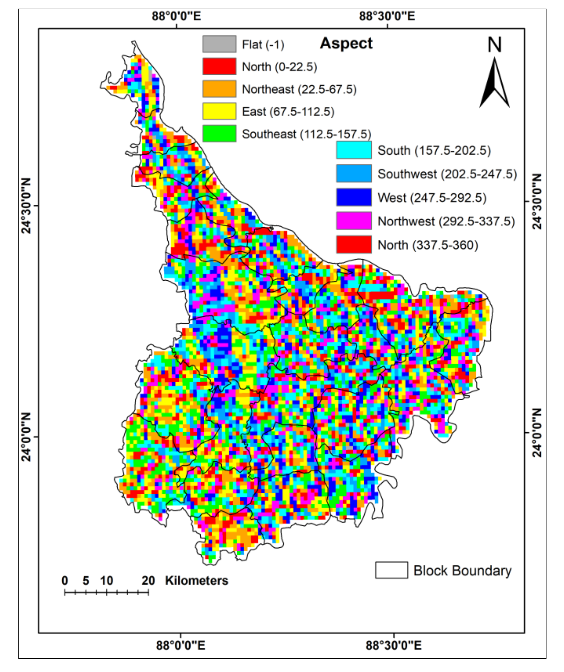
2.4.1. Elevation and Aspect
2.4.2. Hydrogeology
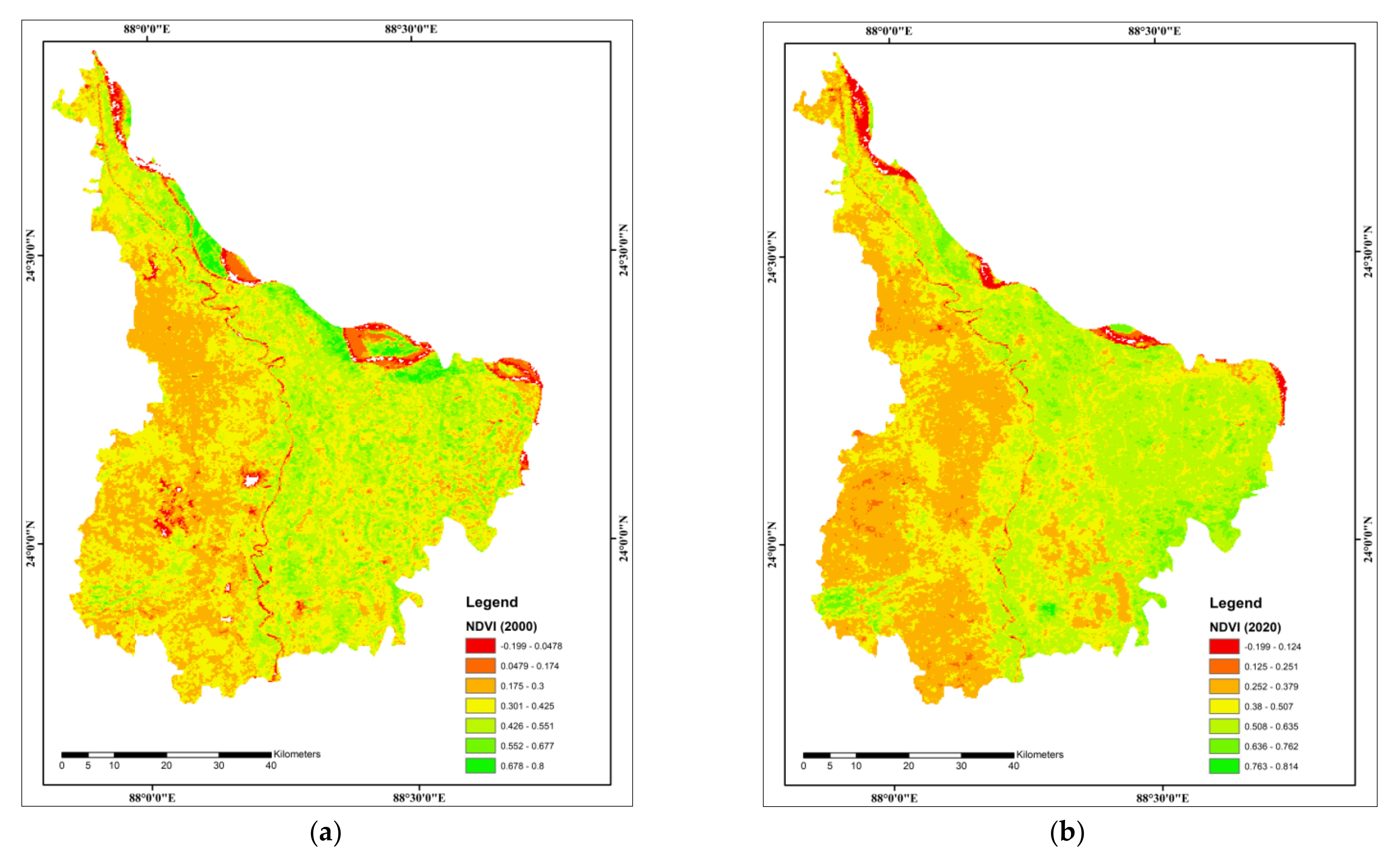
2.4.3. NDVI
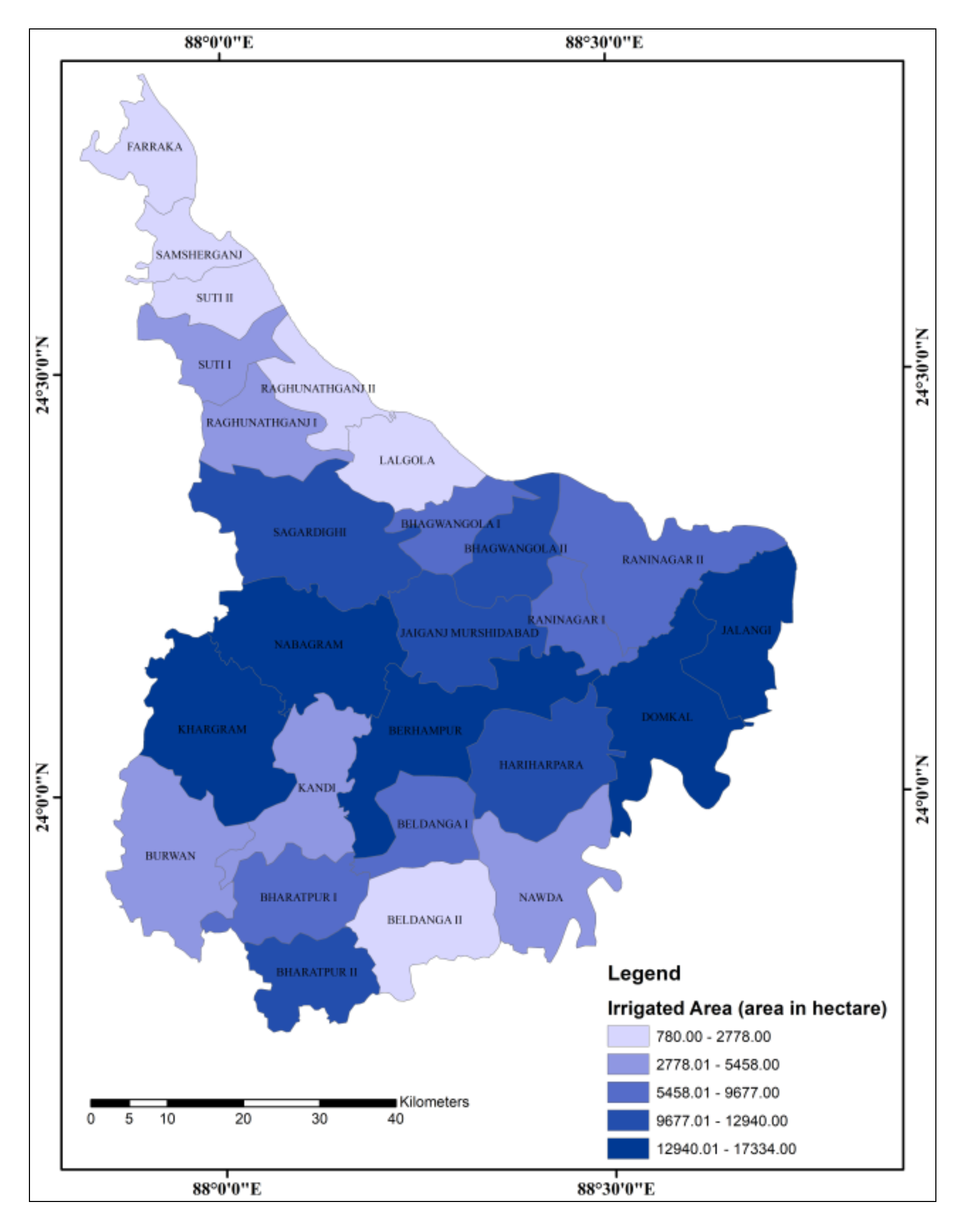
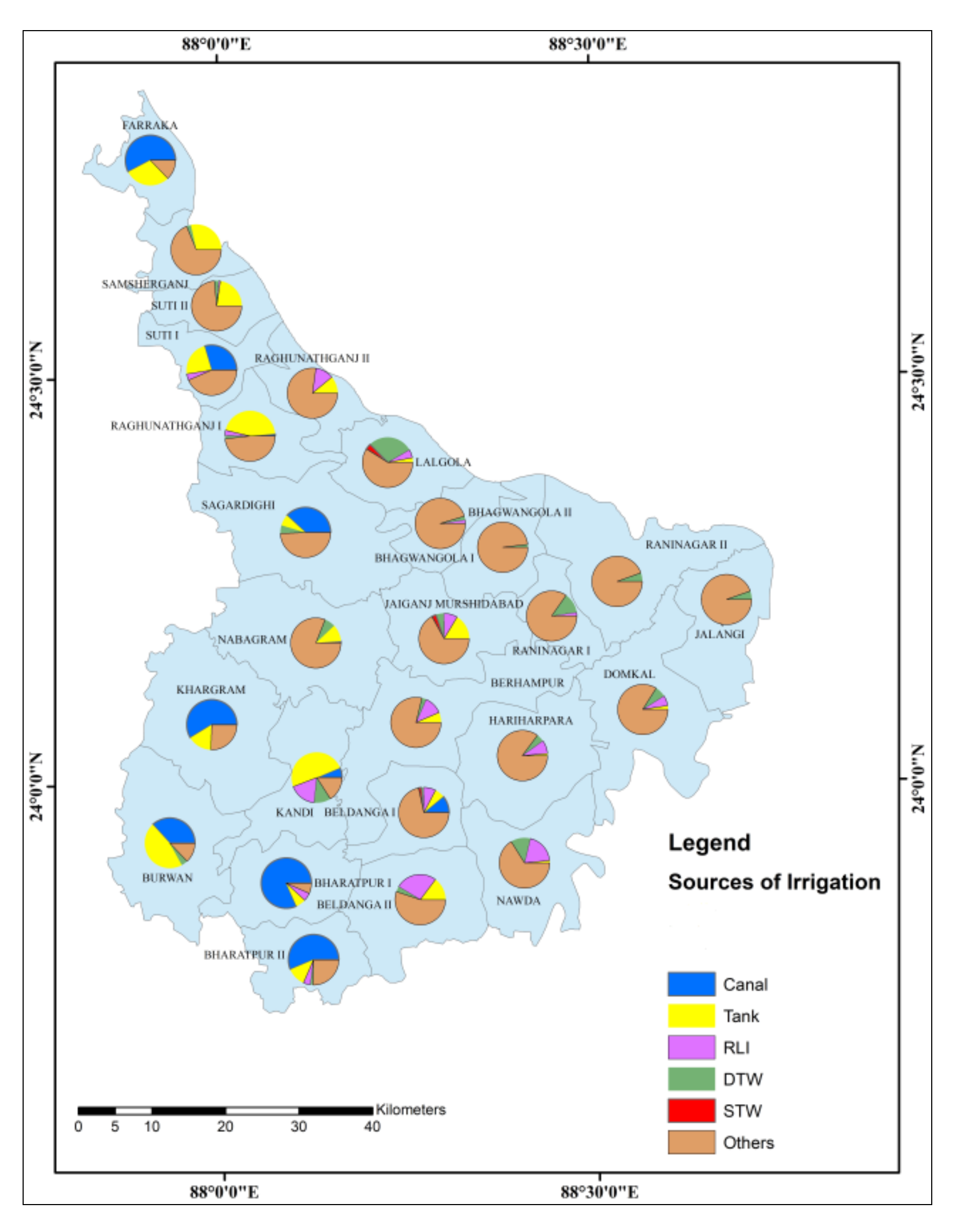
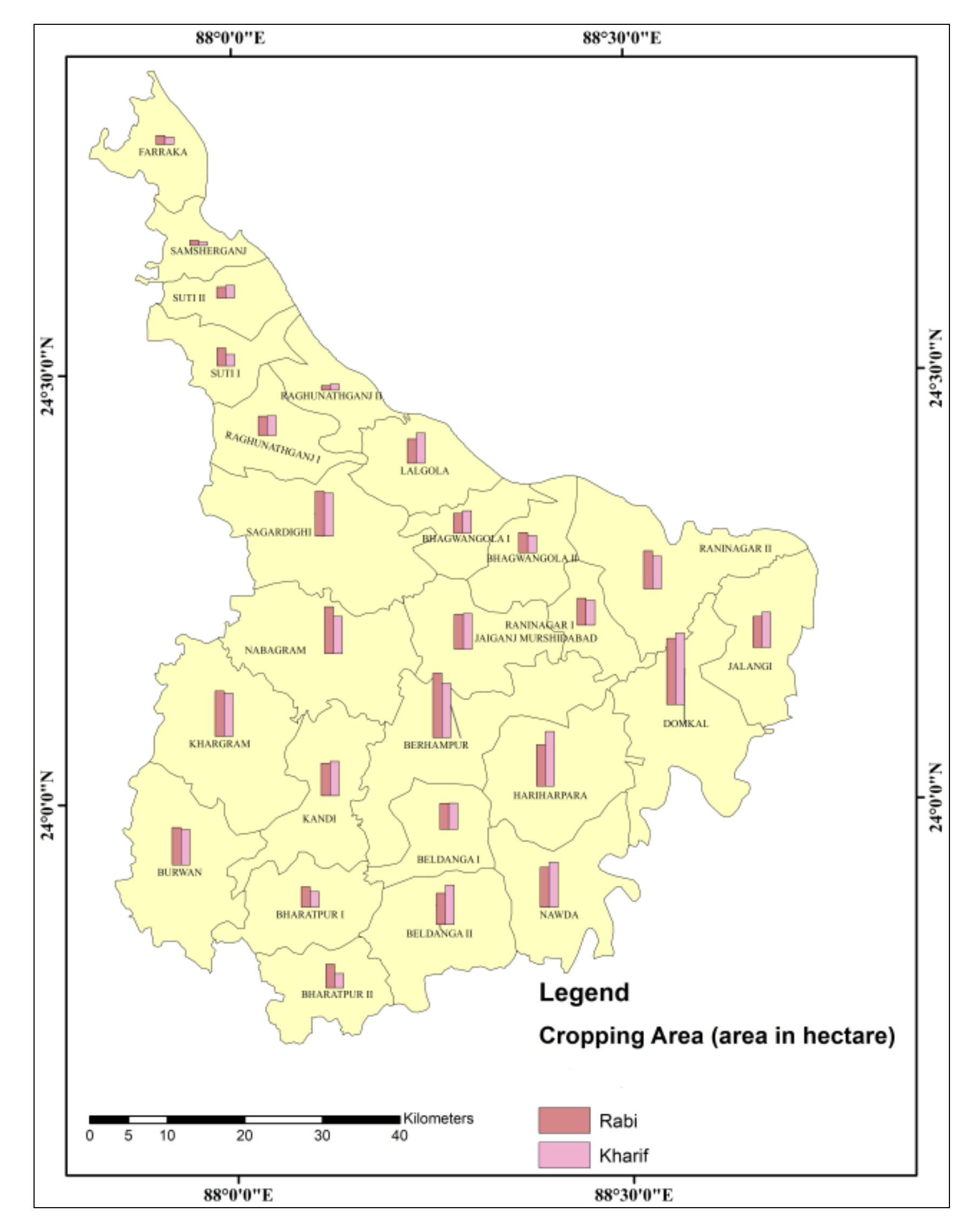
2.4.4. Irrigation and Cropping
2.4.5. Slope
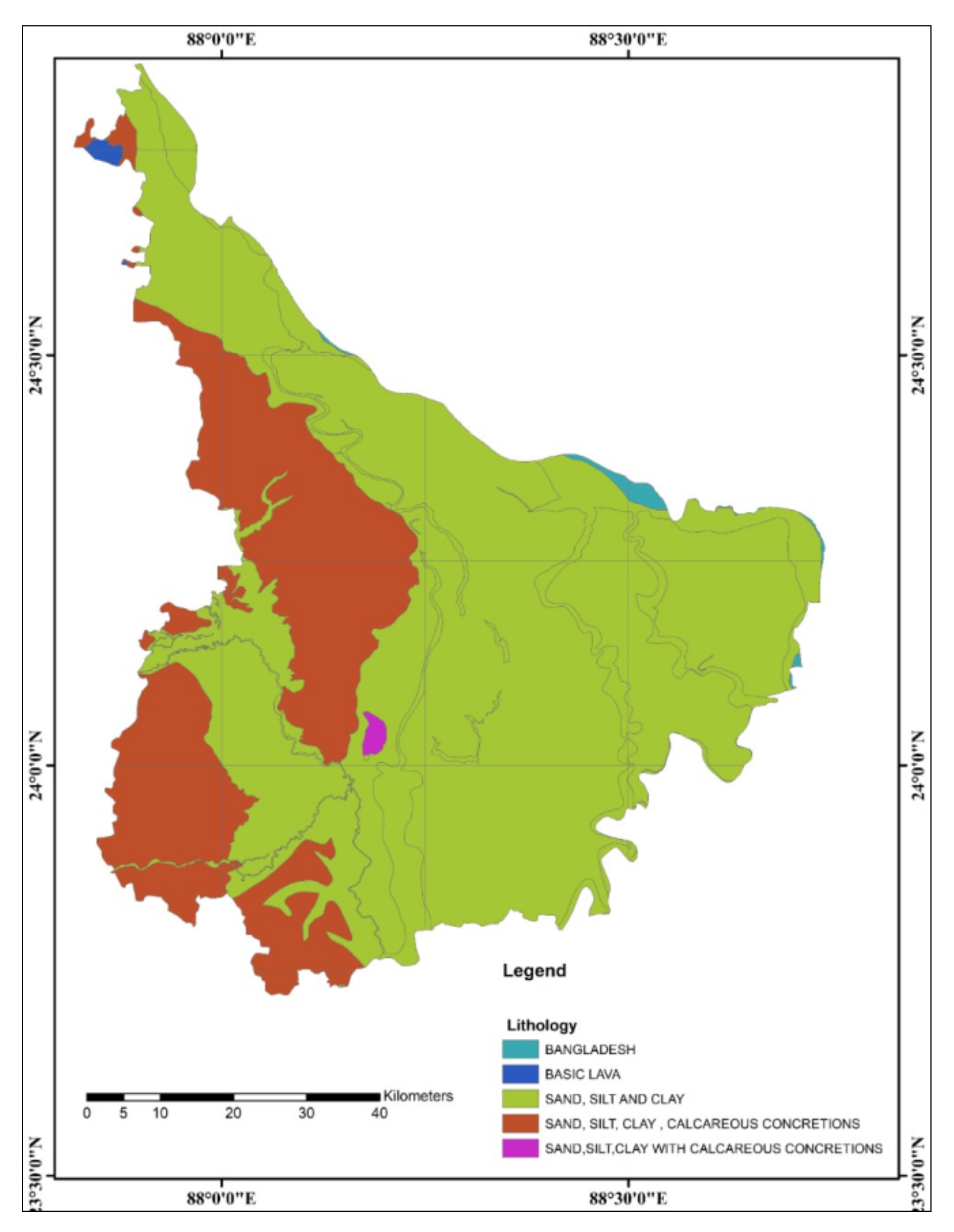
2.4.6. Lithology
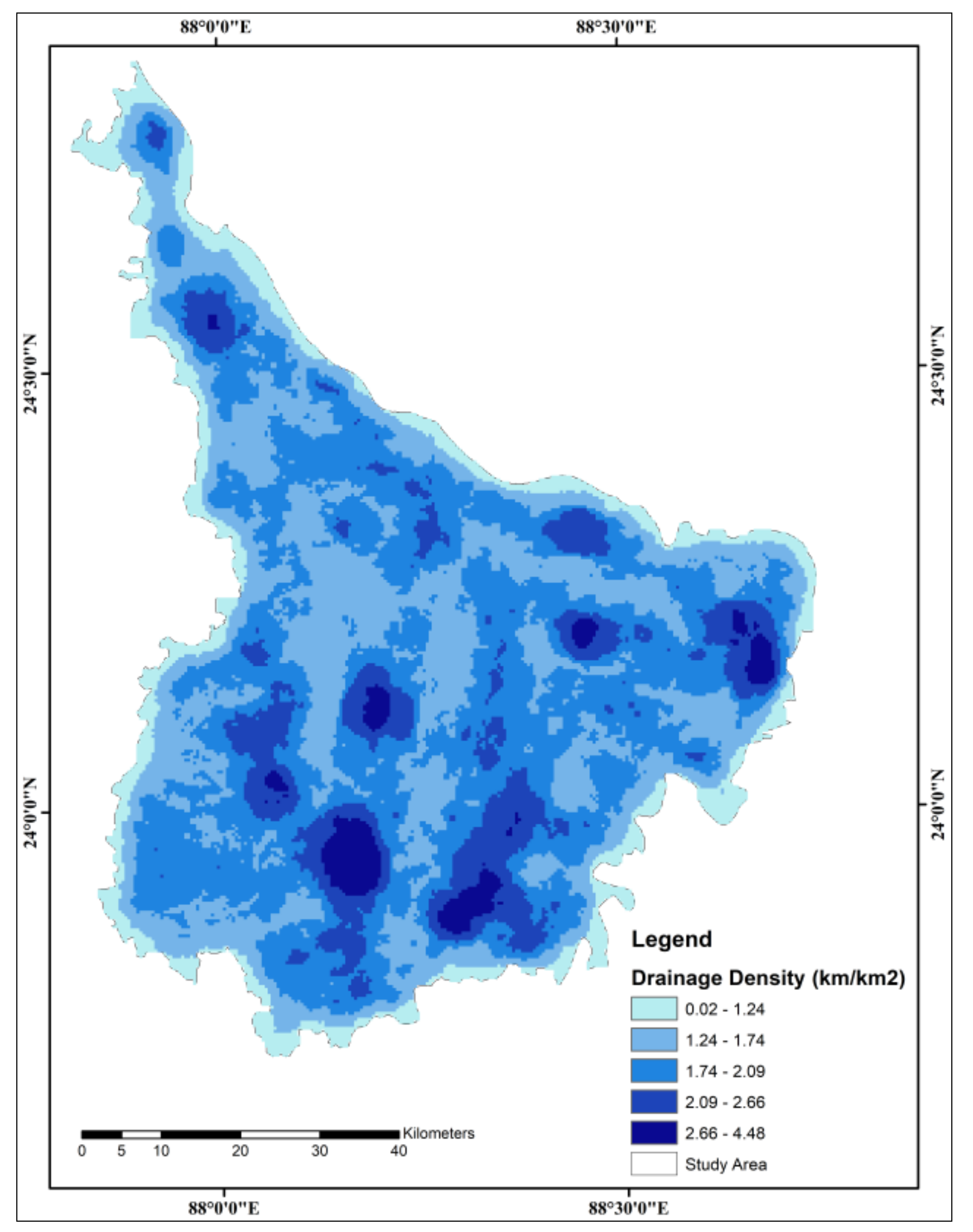
2.4.7. Drainage Density
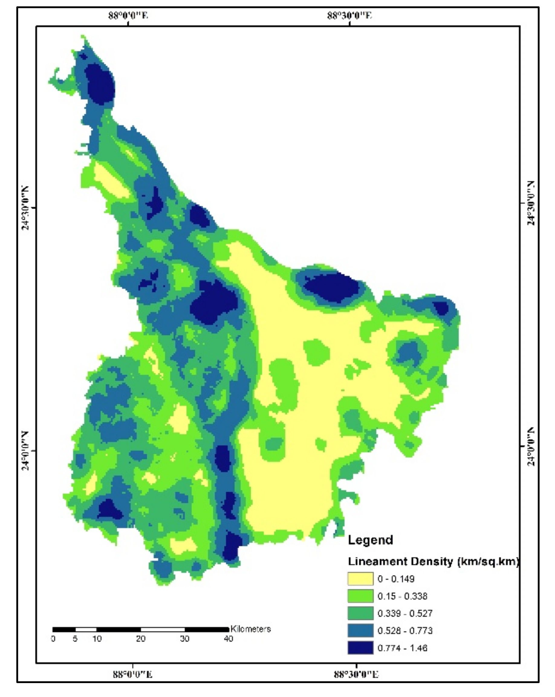
2.4.8. Lineament Density
2.4.9. Topographic Wetness Index
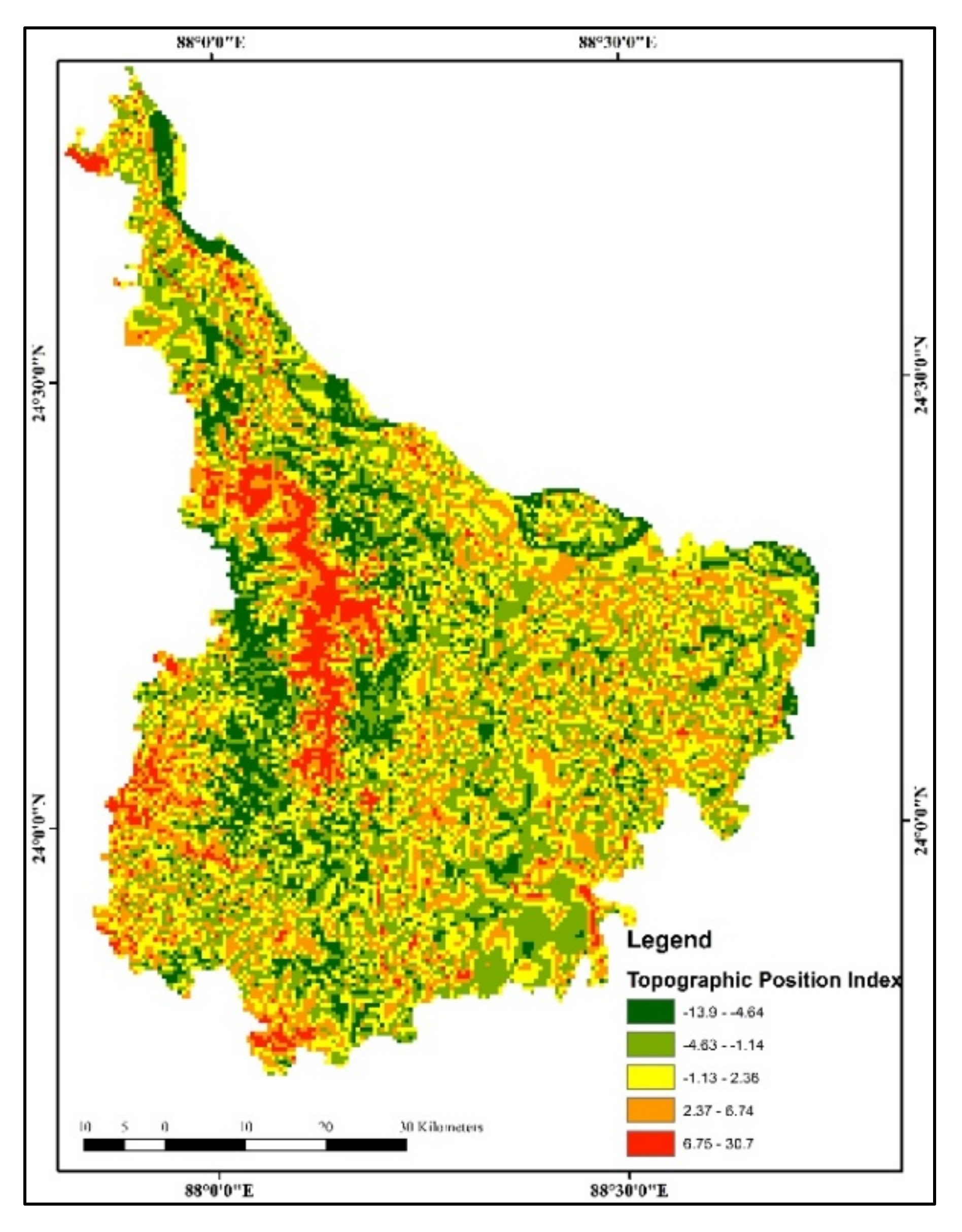
2.4.10. Topographic Position Index
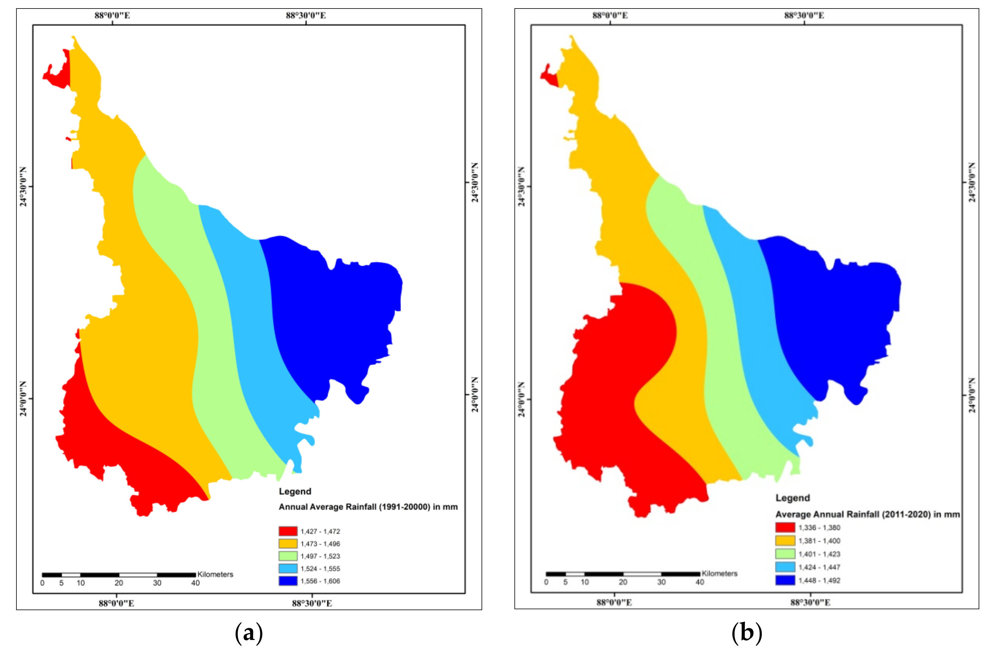
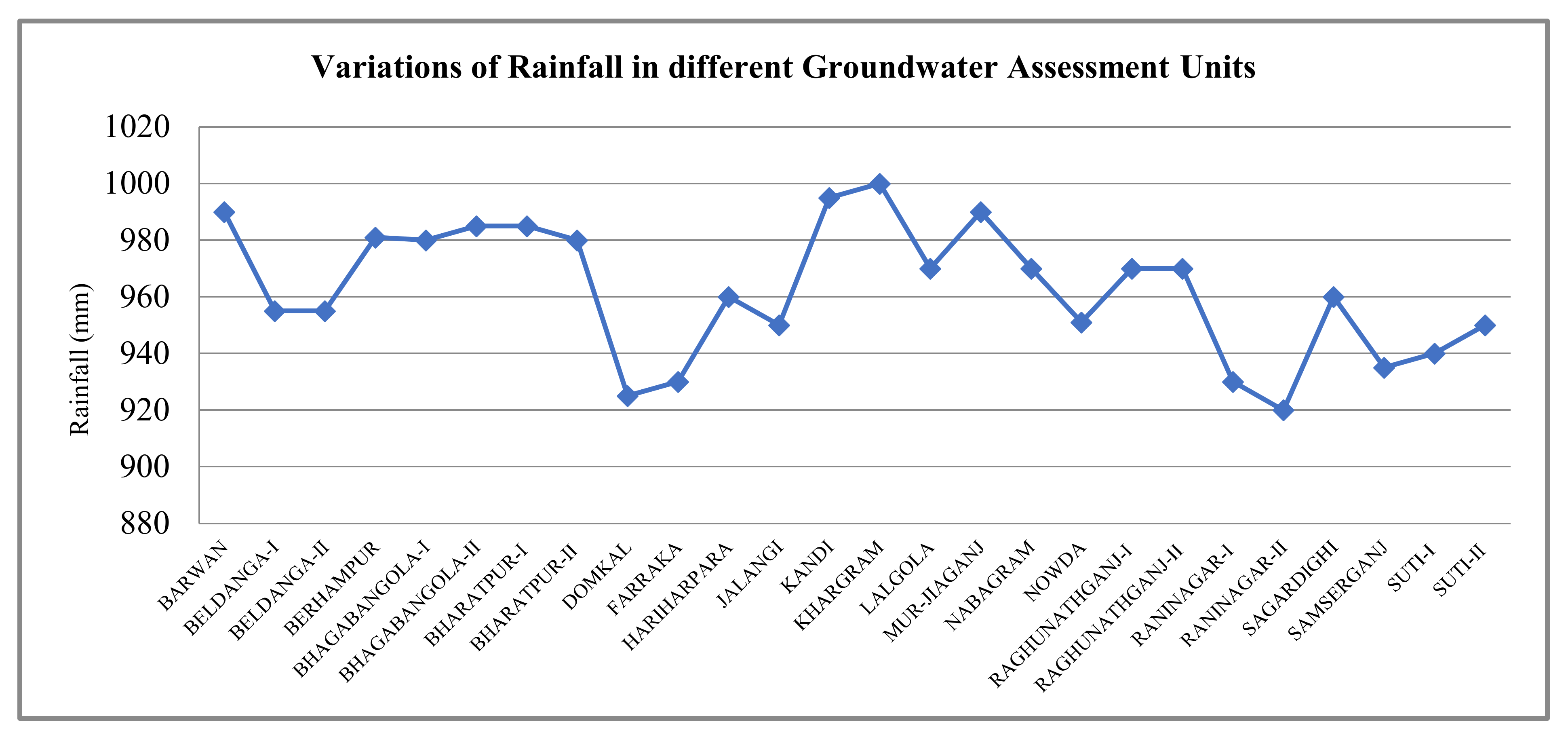
2.4.11. Rainfall
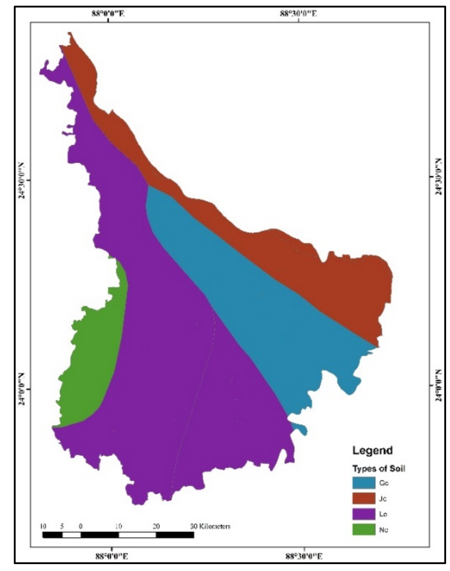
2.4.12. Soil Texture
- Gc (Calcaric Gleysols)—It shows hydromorphic properties of the surface (<50 cm); having only A, H, and B horizons with cambic or calcic or gypsic character.
- Jc (Calcaric Fluvisols)—It is generated from fresh alluvial deposits with ochric or umbric or sulfuric horizons. Conditionally, they have high resilience and low sensitivity, but are much prized for intensive agriculture.
- Lo (Orthic Luvisols)—It has a high pedestal saturation (>50%), which is seriously exaggerated by water erosion and thus has low organic matter.
- Ne (Eutric Nitosols)—It is considered as the most excellent and fertile soils of the tropics as it can suffer acidity and P-fixation. It has modest toughness and a reasonable to stumpy compassion. It was found in the western parts of the district, which is not suitable for groundwater storage.
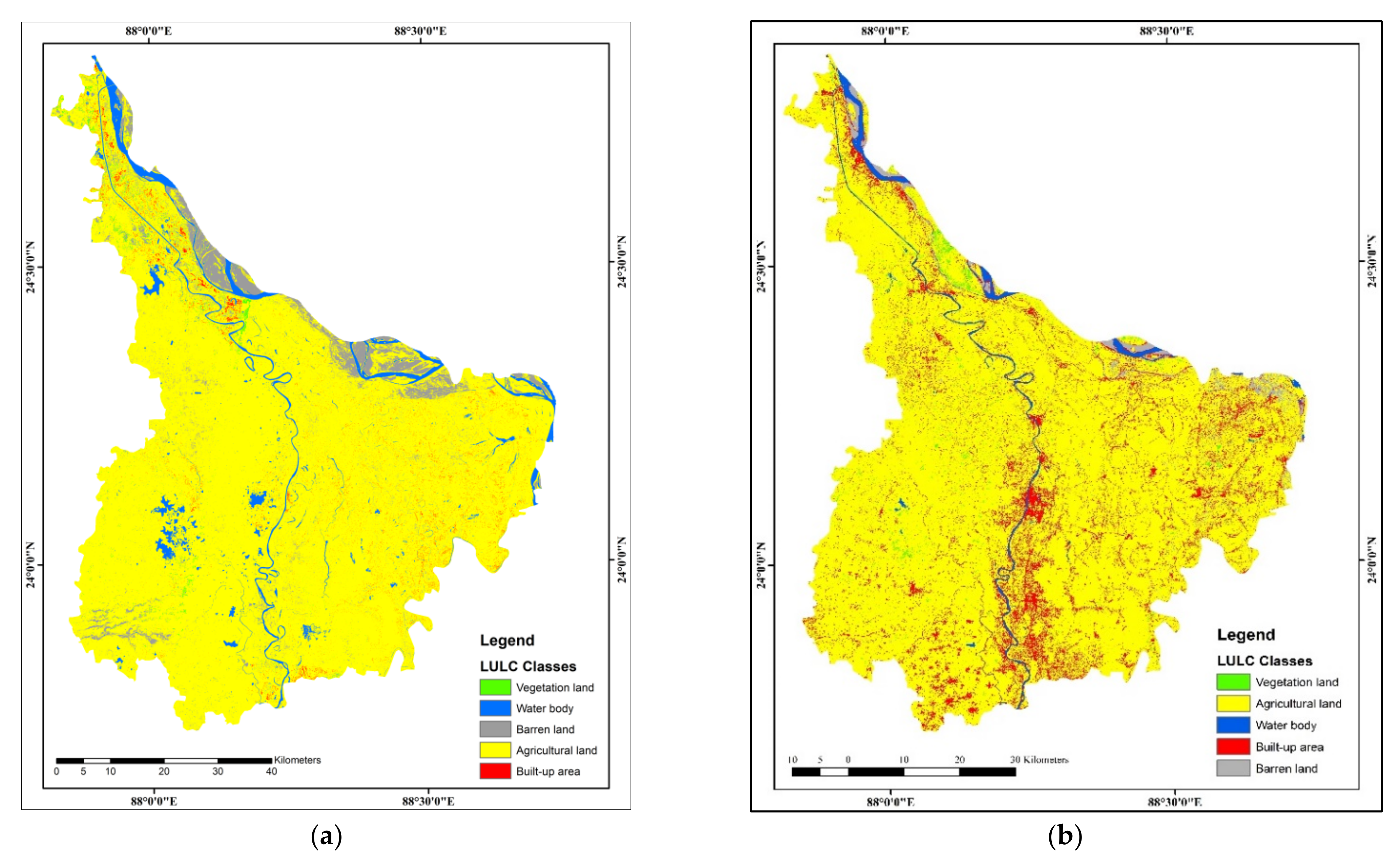
2.4.13. Land Use Land Cover (LULC)
3. Results
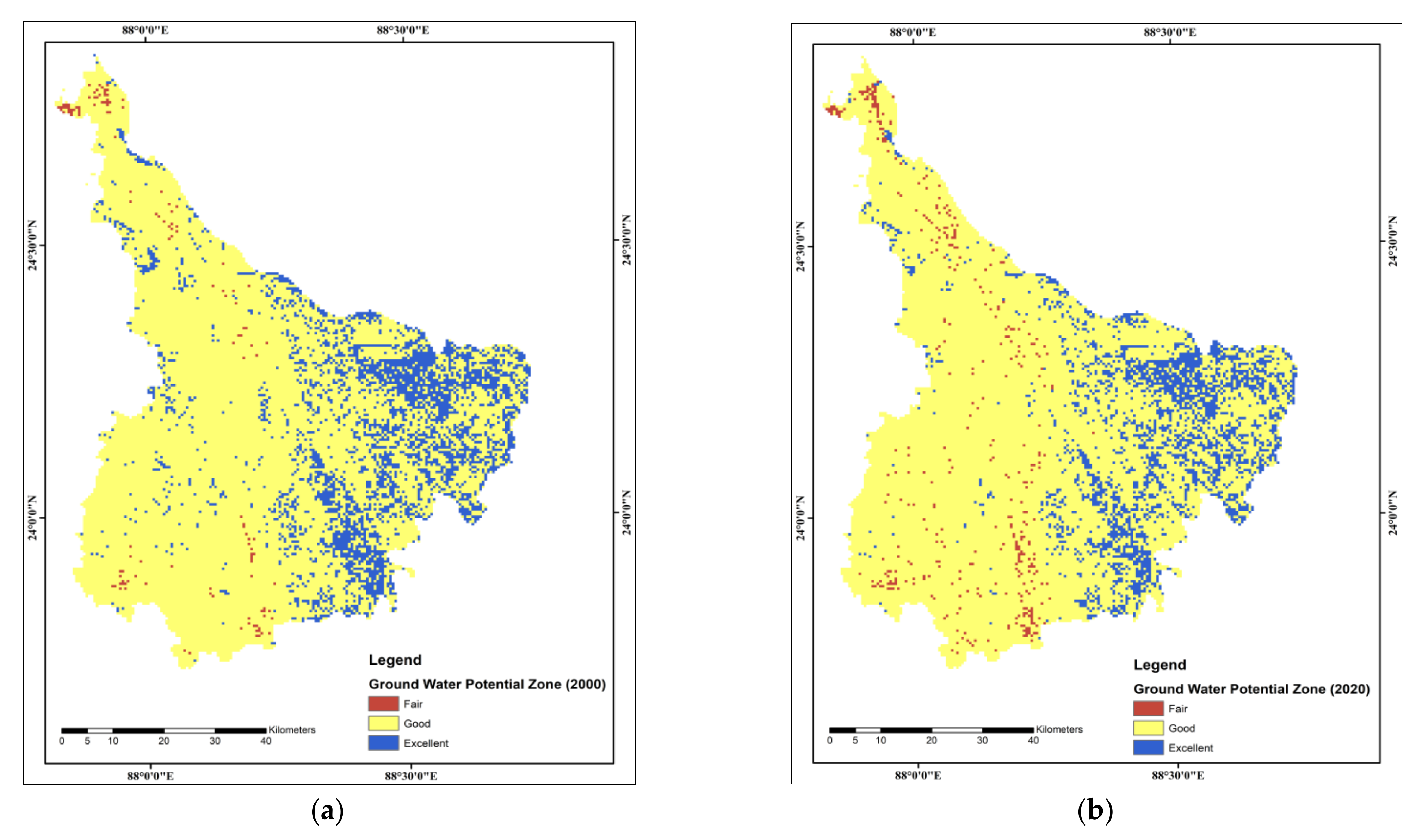
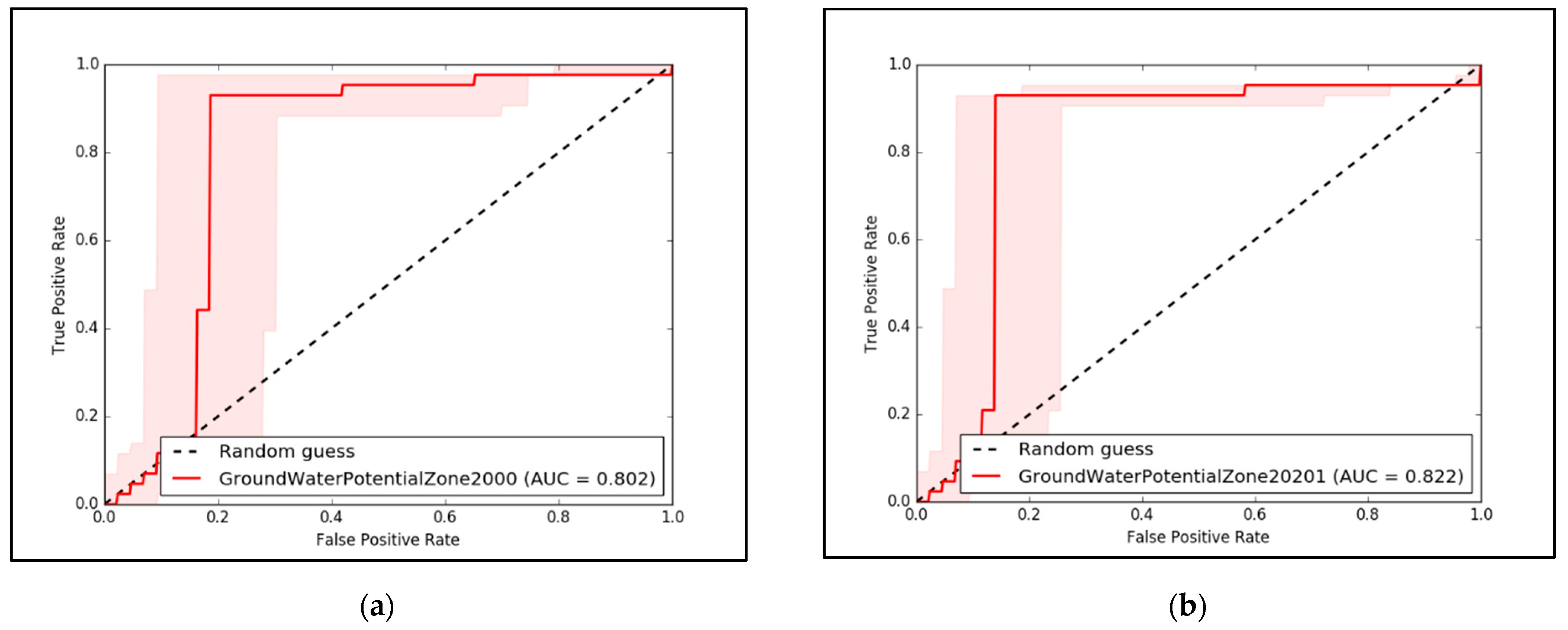
3.1. Groundwater Potential Zone
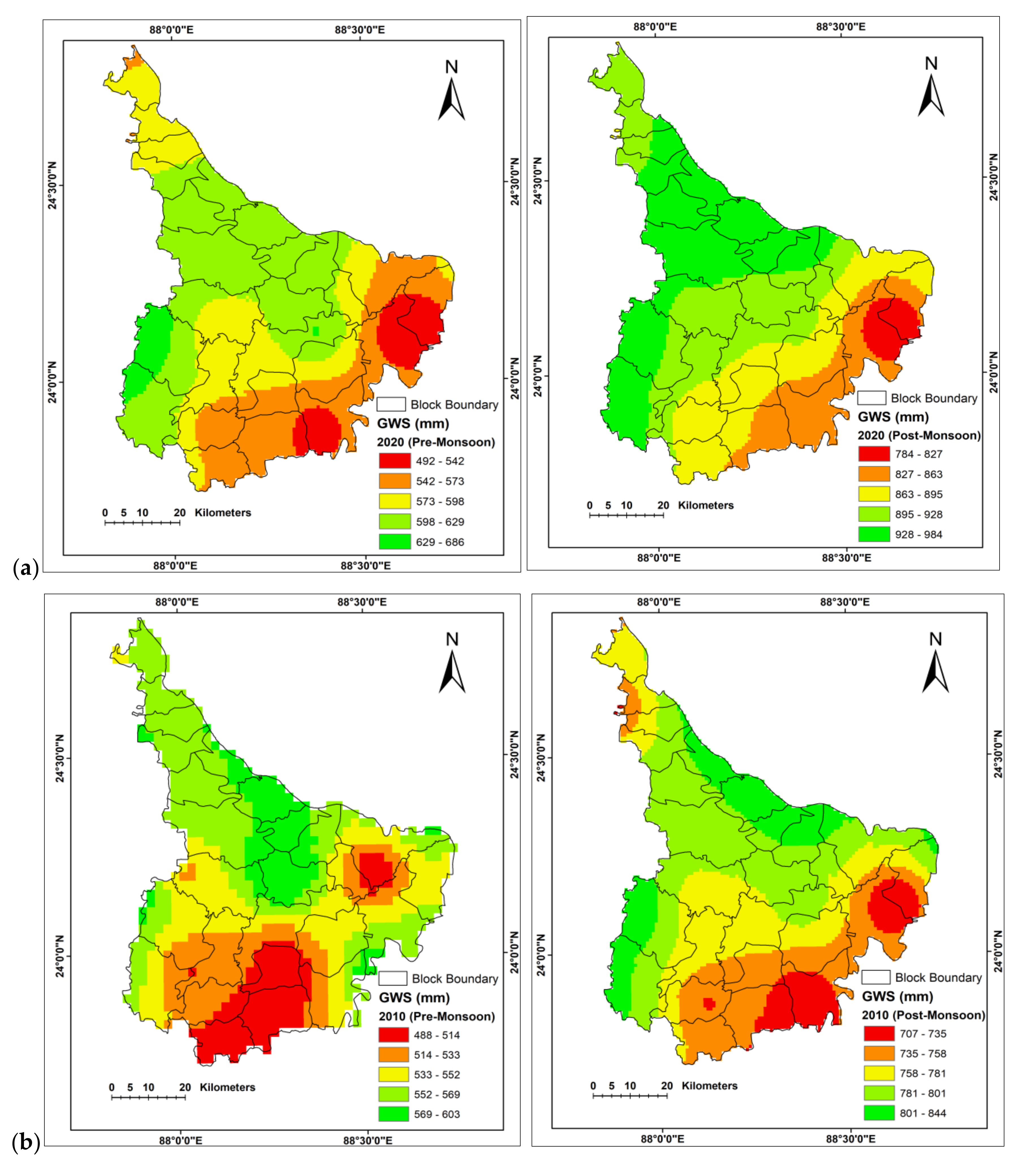
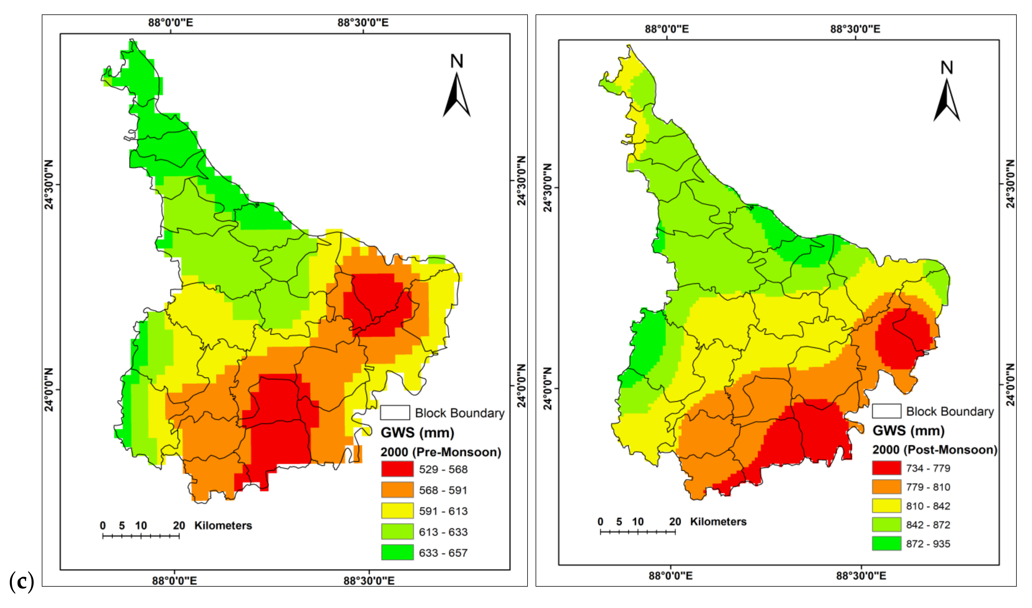
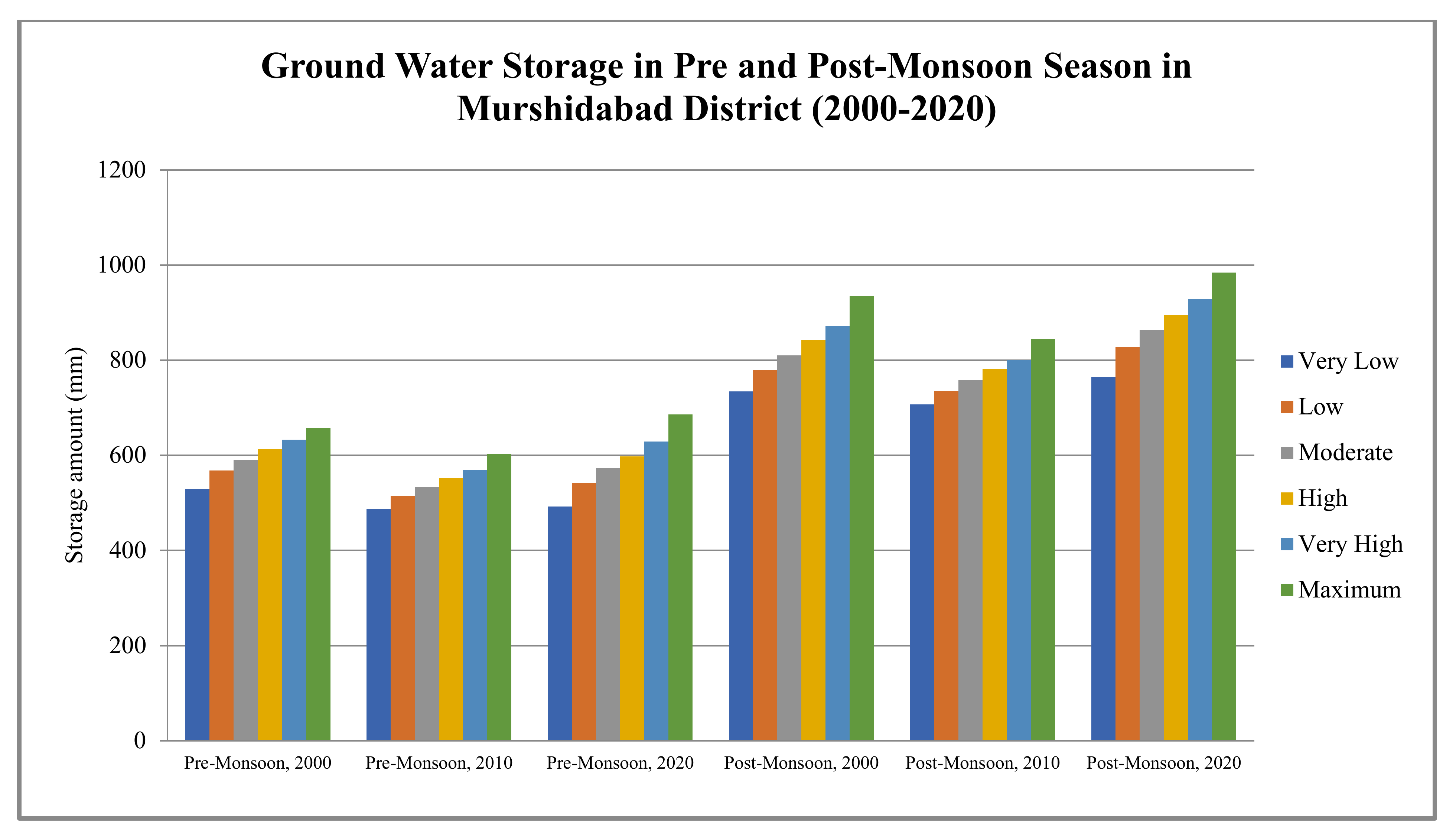
3.2. Groundwater Storage
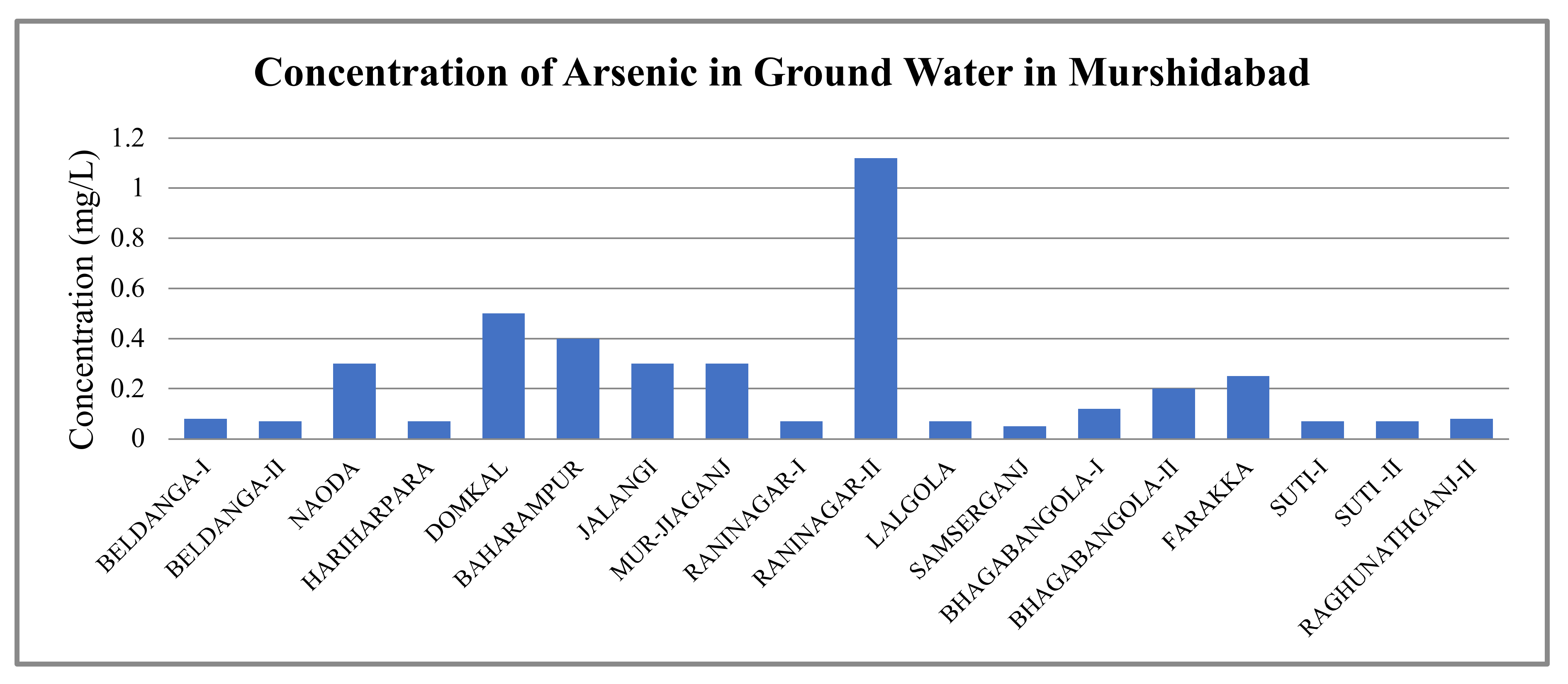
3.3. Arsenic Contamination
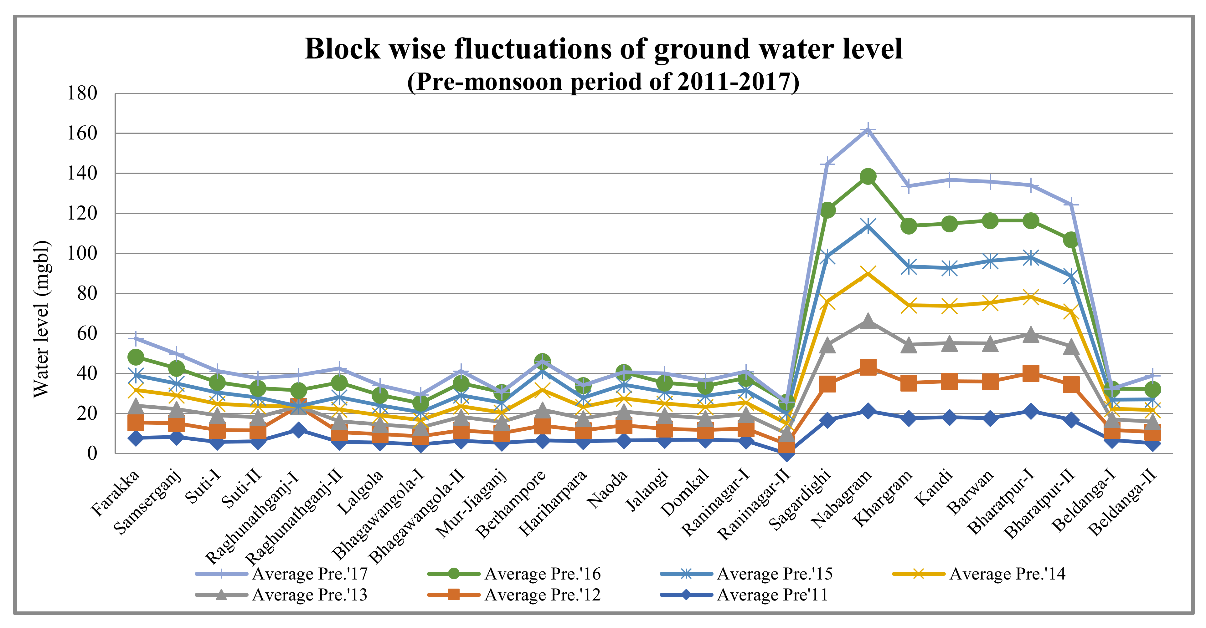
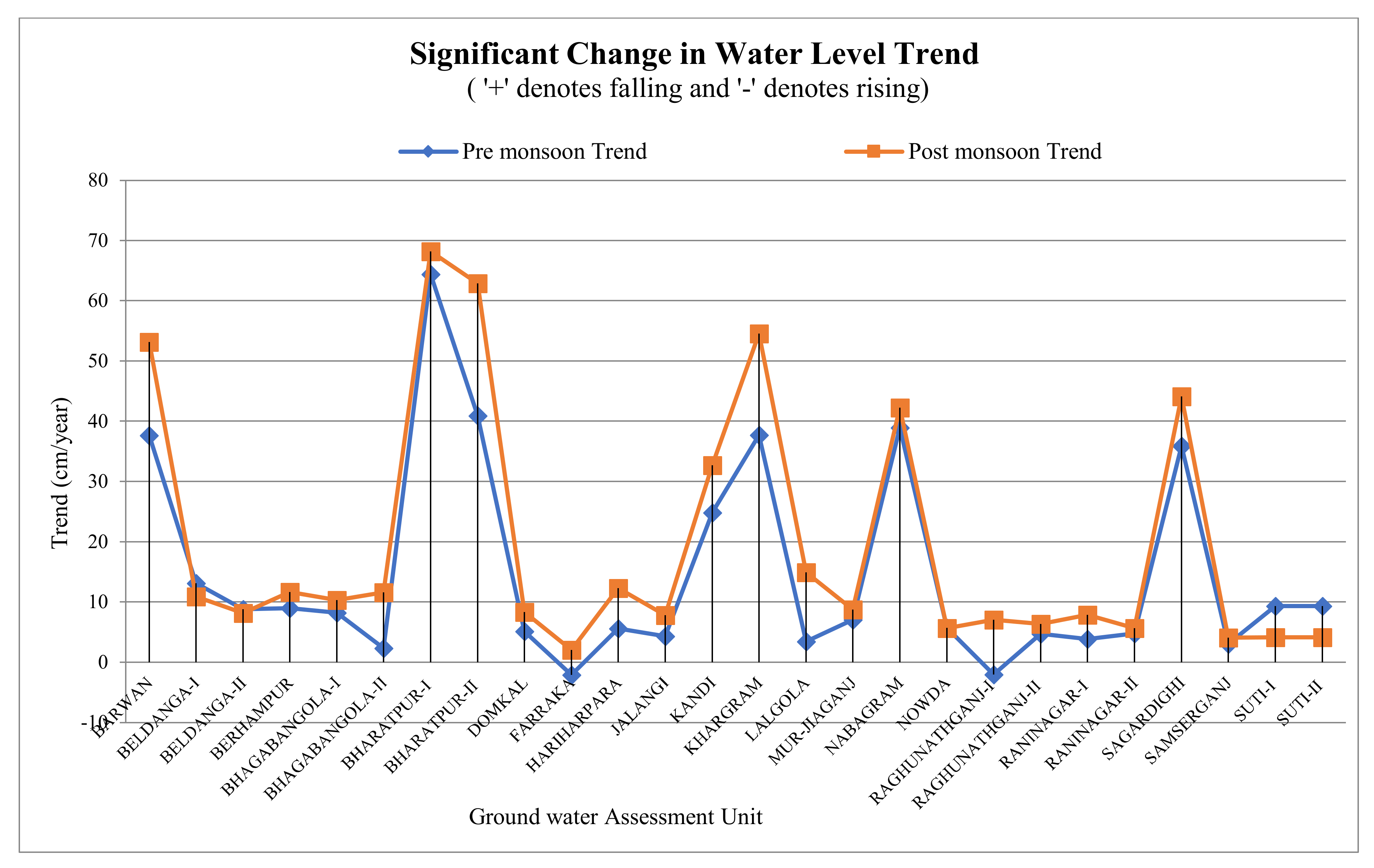
3.4. Groundwater Depth
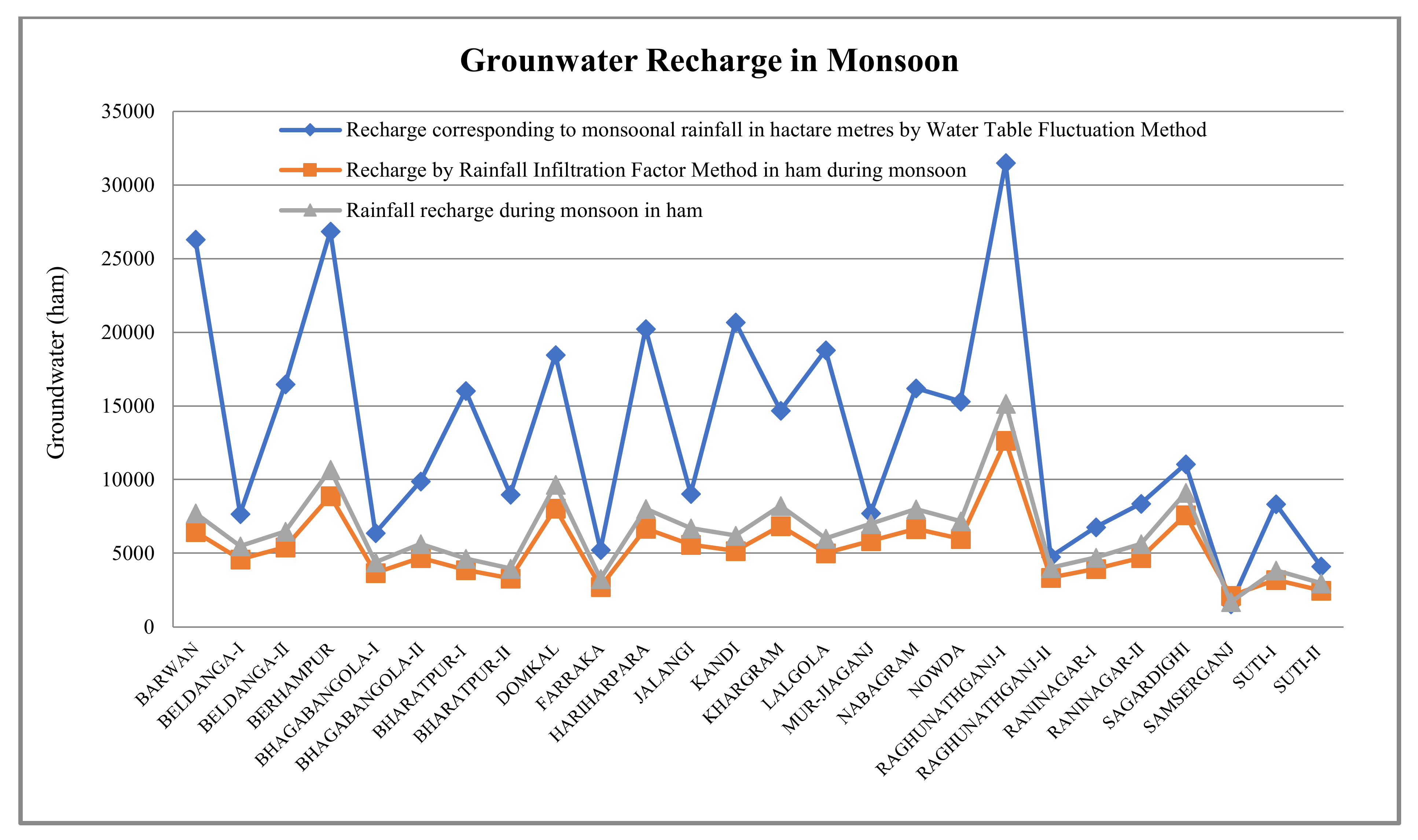
3.5. Groundwater Recharge
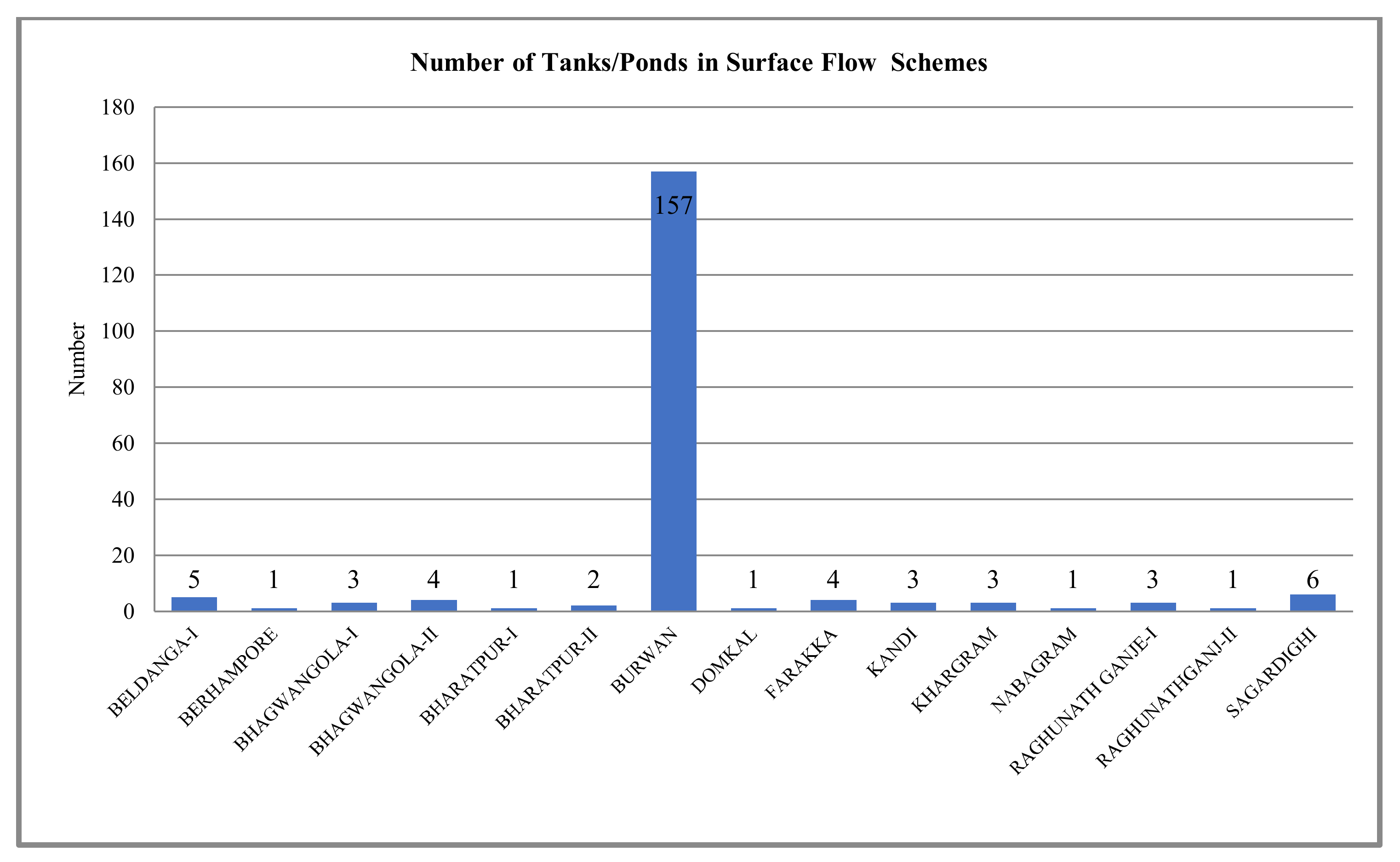
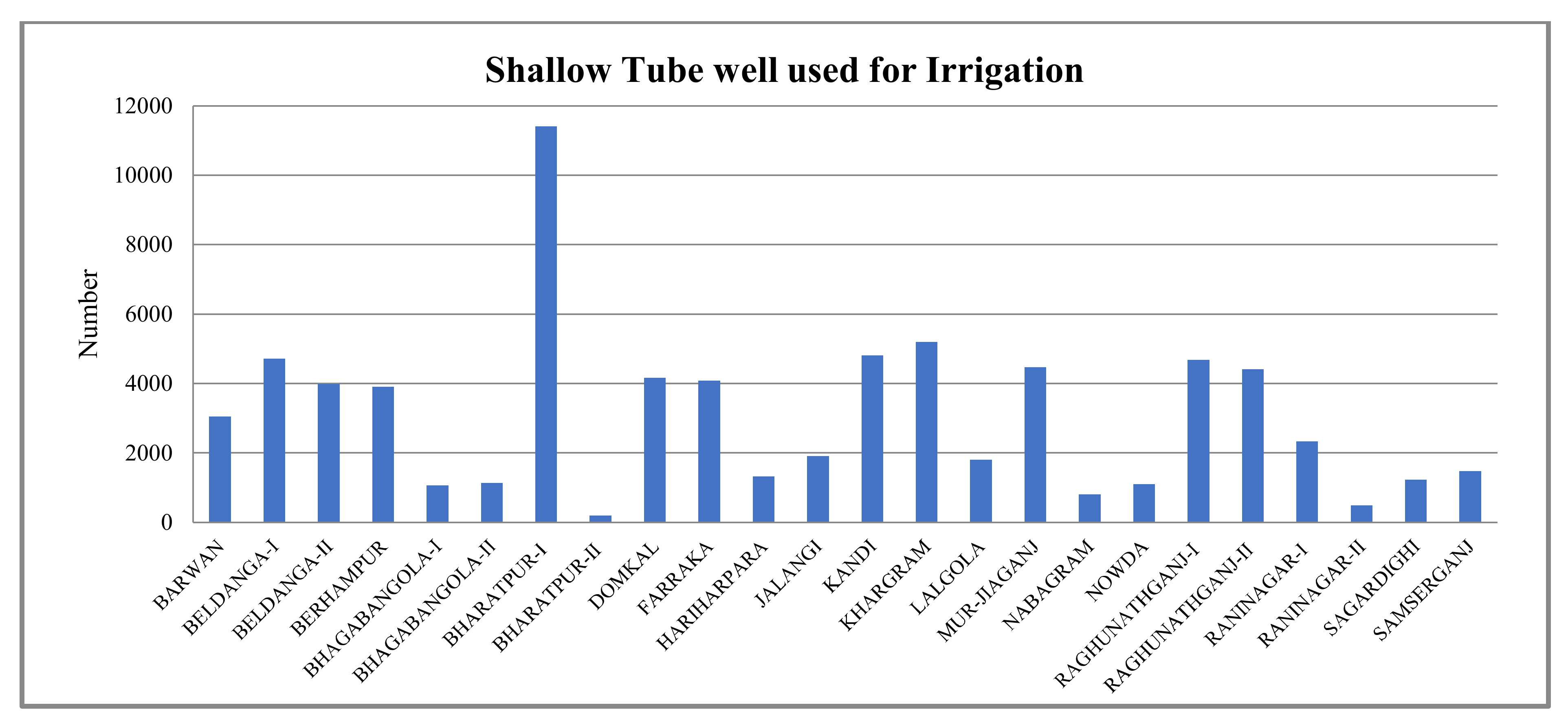
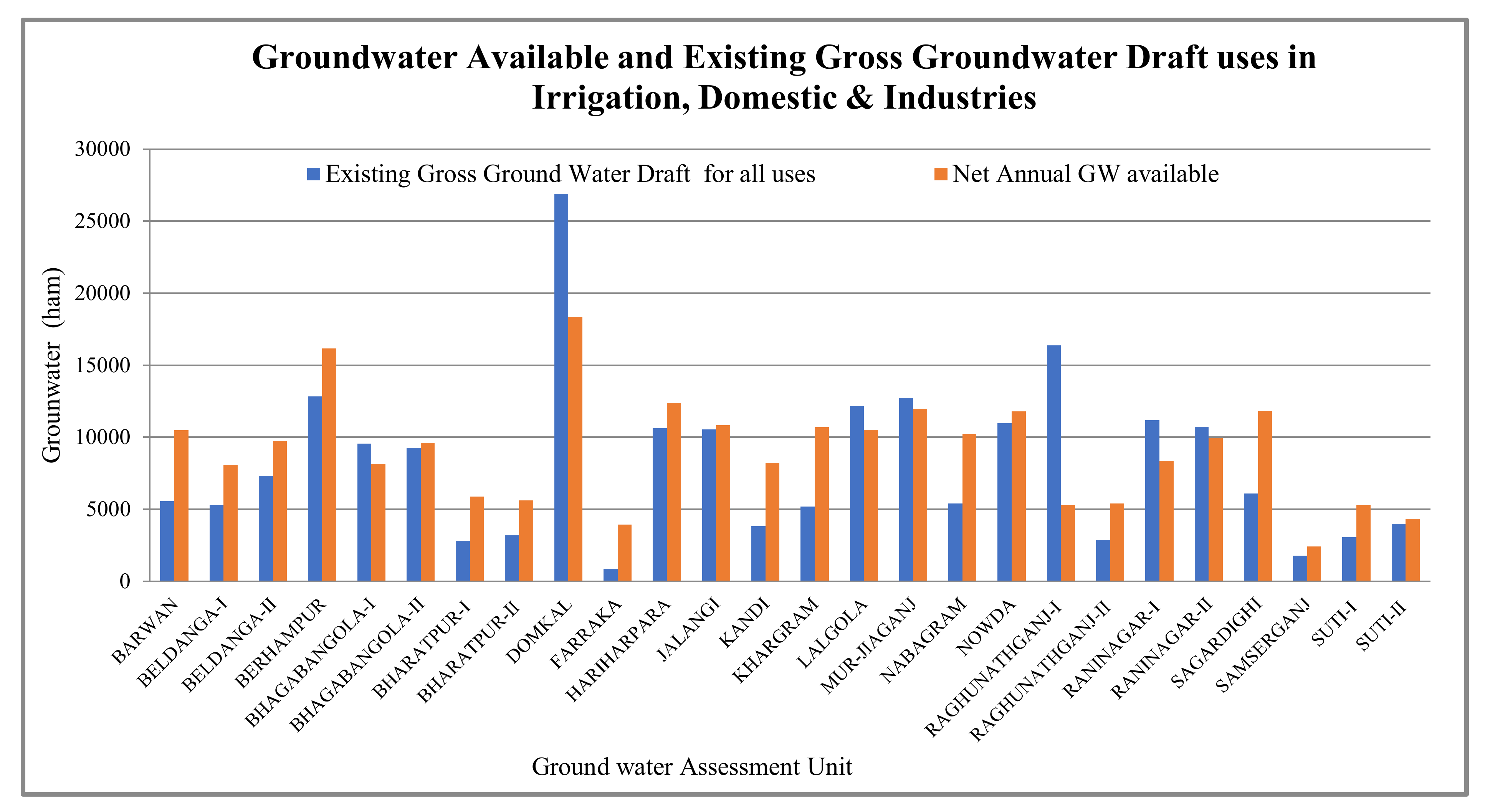
3.6. Utilization of Groundwater
4. Discussion
- The information, maps, upshots gathered in the present endeavour ought to be included in strategy planning in an appropriate way. Thus, the efficient water uses in most of the blocks of the district can be ensured as the net annual groundwater is more than its gross uses.
- The block level micro-planning, and sustainable groundwater scheduling should be accentuated by endorsing exterior water protection, an astute use of water, configuration of progressive tariffs on water, enhancing consciousness, promoting water-saving practices, apposite irrigation planning and systematic scheduling of water distribution.
- The supervision and arrangement of GWS and integrated and restricted LULC must be encouraged and howsoever, upgrading the local governance, building of strategic control in excess of the infrastructural expansion by executing and implementing plans at the blocks, as it is painstaking as a momentous administrative unit.
- The awareness regarding the enhanced reality of depletion, oscillations, scarcity, pollution of water and arsenic contamination, and its repercussions must be initiated and the sensible, efficient and effective exercise of water must be improved and continued.
- The local governing bodies and NGOs should be encouraged to campaign on apposite capacity building and a vigilance curriculum should be instigated regarding the GWS and interrelated concern.
- The availability of adequate water storage data from large observation wells, and a comprehensive study on the spatio-temporal disparity of water storage using the geospatial technology should be initiated in the district, followed by intensive spatial planning for the proficient management.
- The planning must include a vigilant inspection to generate and store pertinent and updated data of water storage and related concerns, along with the maps generated through employing geospatial techniques andthe application of scientific methods, as well as the physical and demographic temperaments of each blocks and overall standing of groundwater of the district.
5. Conclusions
Author Contributions
Funding
Institutional Review Board Statement
Informed Consent Statement
Data Availability Statement
Acknowledgments
Conflicts of Interest
References
- Siebert, S.; Burke, J.; Faures, J.; Frenken, K.; Hoogeveen, J.; Doll, P.; Portmann, F. Groundwater use for irrigation—A global inventory. Hydrol. Earth Syst. Sci. 2010, 14, 1863–1880. [Google Scholar] [CrossRef] [Green Version]
- Kumar, R.S. Water resources of India. Curr. Sci. 2005, 89, 794–811. [Google Scholar]
- Mall, R.K. Water resources and climate change: An Indian perspective. Curr. Sci. 2006, 90, 1610–1626. [Google Scholar]
- NITI Aayog. India Is Currently Suffering from the Worst Water Crisis in Its History. Composite Water Management Index (CWMI), a National Tool for Water Measurement, Management & Improvement; NITI Aayog: New Delhi, India, 2018. Available online: https://www.niti.gov.in/sites/default/files/2019-06/Final%20Report%20of%20the%20Research%20Study%20on%20%20Composite%20Water%20Resources%20Management%20Index%20for%20Indian%20States%20conducted%20by%20Dalberg%20Global%20Development%20Advisors%20Pvt.%20Ltd_New%20Delhi.pdf (accessed on 9 October 2020).
- Shekhar, S.; Pandey, A.C. Delineation of groundwater potential zone in hard rock terrain of India using remote sensing, geographical information system (G.I.S.) and analytic hierarchy process (AHP) techniques. Geocarto Int. 2015, 30, 402–421. [Google Scholar] [CrossRef]
- Ministry of Water Resources. Report of the Groundwater Resource Estimation Committee; Ministry of Water Resources, Government of India: New Delhi, India, 2009.
- Gun, J.V.D. Groundwater and Global Change: Trends, Opportunities and Challenges; UNESCO World Water Assessment Programme, Side Publication Series: Paris, France, 2012. Available online: https://unesdoc.unesco.org/ark:/48223/pf0000215496 (accessed on 10 November 2020).
- India Water Portal. Groundwater Depletes in North and East India. 2019. Available online: https://www.indiawaterportal.org/articles/groundwater-depletion-north-and-east-india (accessed on 24 September 2020).
- Shah, T. India’s Ground Water Irrigation Economy: The Challenge of Balancing Livelihoods and Environment. International Water Management Institute, Anand. 2009. Available online: https://cgwb.gov.in/documents/papers/incidpapers/Paper%203-%20Tushaar%20Shah.pdf (accessed on 2 March 2021).
- Zaveri, E.; Grogan, D.S.; Fisher-Vanden, K.; Frolking, S.; Lammers, R.B.; Wrenn, D.H. Invisible water, visible impact: Groundwater use and Indian agriculture under climate change. Environ. Res. Lett. 2016, 11, 084005. [Google Scholar] [CrossRef] [Green Version]
- Tiwari, V.M.; Wahr, J.; Swenson, S. Dwindling groundwater resources in northern India, from satellite gravity observations. Geophys. Res. Lett. 2009, 36, L18401. [Google Scholar] [CrossRef] [Green Version]
- Sharma, C.S. Overdraft in India’s Water Banks: Studying the Effect of Production of Water Intensive Crops on Groundwater Depletion. Master’s Thesis, Georgetown University, Washington, DC, USA, 2016. Available online: https://repository.library.georgetown.edu/bitstream/handle/10822/1040813/Sharma_georgetown_0076M_13240.pdf?sequence=1 (accessed on 2 March 2021).
- Suhag, R. Overview of Groundwater in India. P.R.S. Legislative Research. 2016. Available online: https://www.prsindia.org/administrator/uploads/general/1455682937~Overview%20of%20Ground%20Water%20in%20India.pdf (accessed on 2 March 2021).
- Chindarkar, N.; Grafton, R.Q. India’s depleting groundwater: When science meets policy. Asia Pac. Policy Stud. 2019, 6, 108–124. [Google Scholar] [CrossRef]
- Srivastava, V.K.; Giri, D.N.; Bharadwaj, P. Study and mapping of ground water prospect using remote sensing, G.I.S. and geoelectrical resistivity techniques- A case study of Dhanbad district, Jharkhand, India. J. Ind. Geophys Union 2012, 16, 55–63. [Google Scholar] [CrossRef]
- Central Ground Water Board (CGWB). Ground Water Scenario in India; Ministry of Water Resource, Government of India: New Delhi, India, 2016. Available online: http://cgwb.gov.in/GW-Scenario.html (accessed on 4 February 2022).
- World Bank. India: India’s Water Economy, Bracing for a Turbulent Future; World Bank: Washington, DC, USA, 2005; Available online: https://openknowledge.worldbank.org/handle/10986/8413 (accessed on 4 December 2020).
- Webster, P.J. Monsoons: Processes, predictability, and the prospects for prediction. J. Geophys. Res. 1998, 103, 14451–14510. [Google Scholar] [CrossRef]
- Douglas, E.M. Changes in moisture and energy fluxes due to agricultural land use and irrigation in the Indian Monsoon Belt. Geophys. Res. Lett. 2006, 33, L14403. [Google Scholar] [CrossRef] [Green Version]
- Jia, B.; Cai, X.; Zhao, F.; Liu, J.; Chen, S.; Luo, X.; Xu, J. Potential future changes of terrestrial water storage based on climate projections by ensemble model simulations. Adv. Water Resour. 2020, 142, 103635. [Google Scholar] [CrossRef]
- Prasood, S.P.; Mukesh, M.V.; Rani, V.R.; Sajinkumar, K.S.; Thrivikramji, K.P. Urbanization and its effects on water resources: Scenario of a tropical river basin in South India. Remote Sens. Appl. Soc. Environ. 2021, 23, 100556. [Google Scholar] [CrossRef]
- Joshi, S.K.; Gupta, S.; Sinha, R.; Densmore, A.L.; Rai, S.P.; Shekhar, S.; Van, D.W.M. Strongly heterogeneous patterns of groundwater depletion in north-western India. J. Hydrol. 2021, 598, 126492. [Google Scholar] [CrossRef]
- Tangdamrongsub, N.; Hwang, C.; Borak, J.S.; Prabnakorn, S.; Han, J. Optimizing GRACE/GRACE-FO data and a priori hydrological knowledge for improved global terrestial water storage component estimates. J. Hydrol. 2021, 598, 126463. [Google Scholar] [CrossRef]
- Rodell, M.C. Estimating groundwater storage changes in the Mississippi River basin (U.S.A.) using GRACE. Hydrogeol. J. 2007, 15, 159–166. [Google Scholar] [CrossRef] [Green Version]
- Rodell, M.V. Satellite-based estimates of groundwater depletion in India. Nature 2009, 460, 999–1002. [Google Scholar] [CrossRef] [Green Version]
- Scanlon, B.R. Ground referencing GRACE satellite estimates of groundwater storage changes in the California Central Valley, U.S.A. Water Resour. Res. 2012, 48, W04520. [Google Scholar] [CrossRef] [Green Version]
- Shamsudduha, M.T. Monitoring groundwater storage changes in the Bengal Basin: Validation of GRACE measurements. Water Resour. Res. 2012, 48, W02508. [Google Scholar] [CrossRef] [Green Version]
- Richey, A.S.; Thomas, B.F.; Lo, M.H.; Reager, J.T.; Famiglietti, J.S.; Voss, K.; Swenson, S.; Rodell, M. Quantifying renewable groundwater stress with GRACE. Water Resour. Res. 2015, 51, 5217–5238. [Google Scholar] [CrossRef]
- Long, D.C. Have GRACE satellites overestimated groundwater depletion in the Northwest India Aquifer? Sci. Rep. 2016, 6, 24398. [Google Scholar] [CrossRef]
- Chen, J.L. Long-term groundwater storage change in Victoria, Australia from satellite gravity and in situ observations. Glob. Planet. Change 2016, 139, 56–65. [Google Scholar] [CrossRef] [Green Version]
- Bhanja, S.N. Validation of GRACE based groundwater storage anomaly using in situ groundwater level measurements in India. J. Hydrol. 2016, 543, 729–738. [Google Scholar] [CrossRef]
- Bhanja, S.N. Groundwater Storage Variations in India. In Groundwater of South Asia; Springer: Singapore, 2018; pp. 49–59. [Google Scholar]
- Mukherjee, A.; Fryar, A.E. Deeper groundwater chemistry and geochemical modeling of the arsenic affected the western Bengal basin, West Bengal, India. Appl. Geochem. 2008, 3, 863–894. [Google Scholar] [CrossRef]
- Michael, H.A. Controls on groundwater flow in the Bengal Basin of India and Bangladesh: Regional modeling analysis. Hydrogeol. J. 2009, 17, 1561–1577. [Google Scholar] [CrossRef]
- Sikdar, P.K. Migration of arsenic in multi-aquifer system of Bengal Basin: Analysis via numerical modeling. Environ. Earth Sci. 2013, 70, 1863–1879. [Google Scholar] [CrossRef]
- Nejad, S.G.; Falah, F.; Daneshfar, M.; Haghizadeh, A.; Rahmati, O. Delineation of groundwater potential zones using remote sensing and GIS-based data-driven models. Geocarto Int. 2017, 32, 167–187. [Google Scholar] [CrossRef]
- Lakshmanan, E.K.R. Major ion chemistry and identification of hydrogeochemical processes of groundwater in a part of Kancheepuram district, Tamil Nadu, India. Environ. Geosci. 2003, 10, 157–166. [Google Scholar] [CrossRef]
- Rajmohan, N. Hydrogeochemistry and its relation to groundwater level fluctuation in the Palar and Cheyyar river basins, southern India. Hydrol. Process. 2006, 20, 2415–2427. [Google Scholar] [CrossRef]
- Brindha, K.A. Impact of tanning industries on groundwater quality near a metropolitan city in India. Water Resour. Manag. 2012, 26, 1747–1761. [Google Scholar] [CrossRef]
- Brindha, K.; Neena, V.K.V.; Srinivasan, K.; Sathis, B.M.; Elango, L. Identification of surface water–groundwater interaction by hydrogeochemical indicators and assessing its suitability for drinking and irrigational purposes in Chennai, southern India. Appl. Water Sci. 2014, 4, 159–174. [Google Scholar] [CrossRef] [Green Version]
- Gizzi, M.; Mondani, M.; Taddia, G.; Suozzi, E.; Lo Russo, S. Aosta Valley Mountain Springs: A Preliminary Analysis for Understanding Variations in Water Resource Availability under Climate Change. Water 2022, 14, 1004. [Google Scholar] [CrossRef]
- Oh, H.J.; Kim, Y.S.; Choi, J.K.; Park, E.; Lee, S. GIS mapping of regional probabilistic groundwater potential in the area of Pohang City. Korea J. Hydrol. 2011, 399, 158–172. [Google Scholar] [CrossRef]
- Mohammadi-Behzad, H.R.; Charchi, A.; Kalantari, N.; Nejad, A.M.; Vardanjani, H.K. Delineation of groundwater potential zones using remote sensing (RS), geographical information system (GIS) and analytic hierarchy process (AHP) techniques: A case study in the Leylia-Keynow watershed, southwest of Iran. Carborates Evaporites 2018, 34, 1307–1319. [Google Scholar] [CrossRef]
- Asoka, A.G.T. The relative contribution of monsoon precipitation and pumping to changes in groundwater storage in India. Nat. Geosci. 2017, 10, 109–117. Available online: https://www.nature.com/articles/ngeo2869 (accessed on 3 January 2022). [CrossRef] [Green Version]
- Bhanja, S.N.; Rodell, M.; Li, B.; Saha, D.; Mukherjee, A. Spatio-temporal variability of groundwater storage in India. J. Hydrol. 2017, 544, 428–437. [Google Scholar] [CrossRef] [PubMed]
- Agarwal, R.; Garg, P.K. Remote sensing and G.I.S. based groundwater potential and recharge zones mapping using multi-criteria decision making technique. Water Resour. Manag. 2013, 30, 243–260. [Google Scholar] [CrossRef]
- Kumar, A.; Sharma, H.C.; Kumar, S. Planning for replenishing the depleted groundwater in upper Gangetic plains using R.S. and G.I.S. Indian J. Soil Conserv. 2011, 39, 195–201. [Google Scholar]
- Arkoprovo, B.; Adarsa, J.; Prakash, S.S. Delineation of groundwater potential zones using satellite remote sensing and geographic information system techniques: A case study from Ganjam district, Orissa, India. Res. J. Recent Sci. 2012, 1, 59–66. [Google Scholar] [CrossRef] [Green Version]
- Das, S.; Pardeshi, S.D. Integration of different influencing factors in GIS to delineate groundwater potential areas using IF and F.R. techniques: A study of Pravara basin, Maharashtra, India. Appl. Water Sci. 2018, 8, 197. [Google Scholar] [CrossRef] [Green Version]
- Ibrahim-Bathis, K.; Ahmed, S.A. Geospatial technology for delineating groundwater potential zones in Doddahalla watershed of Chitradurga district, India. Egypt. J. Remote Sens. Space Sci. 2016, 19, 223–234. [Google Scholar] [CrossRef] [Green Version]
- Qadir, J.; Bhat, M.S.; Alam, A.; Rashid, I. Mapping groundwater potential zones using remote sensing and GIS approach in Jammu Himalaya, Jammu and Kashmir. Geo J. 2019, 85, 487–504. [Google Scholar] [CrossRef]
- Mondal, B.K.; Sahoo, S. Evaluation of spatiotemporal dynamics of water storage changes at block level for sustainable water management in Howrah District of West Bengal. Environ. Dev. Sustain. 2021, 24, 9519–9568. [Google Scholar] [CrossRef]
- Chenini, I.; Ben, M.A.; El.May, M. Groundwater recharge zone mapping using GIS-based multi-criteria analysis: A case study in Central Tunisia (Maknassy basin). Water Resour. Manage. 2010, 24, 921–939. [Google Scholar] [CrossRef]
- Machiwal, D.; Jha, M.K.; Mal, B.C. Assessment of groundwater potential in a semi-arid region of India using remote sensing, G.I.S. and MCDM techniques. Water Resour. Manage. 2011, 25, 1359–1386. [Google Scholar] [CrossRef]
- Kumar, A.; Krishna, A.P. Assessment of groundwater potential zones in coal mining impacted hardrock terrain of India by integrating geospatial and analytic hierarchy process (AHP) approach. Geocarto Int. 2011, 33, 105–129. [Google Scholar] [CrossRef]
- Jha, M.K.; Bongane, G.M.; Chowdary, V.M. Groundwater potential zoning by remote sensing, G.I.S. and MCDM techniques: A case study of eastern India. In Symposium JS.4 at the IAHS and I.A.H. Convention; IAHS Press: Hyderabad, India, 2009; pp. 432–441. [Google Scholar]
- Mundalik, V.; Fernandes, C.; Kadam, A.K.; Umrikar, B.N. Integrated geomorphological, geospatial and AHP technique for groundwater prospects mapping in Basaltic terrain. Hydrospatial Anal. 2018, 2, 16–27. [Google Scholar] [CrossRef] [Green Version]
- Singh, L.K.; Jha, M.K.; Chowdary, V.M. Assessing the accuracy of GIS-based multicriteria decision analysis approaches for mapping groundwater potential. Ecol. Indic. 2018, 91, 24–37. [Google Scholar] [CrossRef]
- Singha, S.S.; Pasupuleti, S.; Singha, S.; Singh, R.; Venkatesh, A.S. Analytic network process based approach for delineation of groundwater potential zones in Korba district, Central India using remote sensing and G.I.S. Geocarto Int. 2019, 36, 1489–1511. [Google Scholar] [CrossRef]
- Halder, S.; Roy, M.B.; Roy, P.K. Fuzzy logic algorithm based analytic hierarchy process for delineation of groundwater potential zones in complex topography. Arab. J. Geosci. 2020, 13, 574. [Google Scholar] [CrossRef]
- Sreedevi, P.D.; Subrahmanyam, K.; Ahmed, S. Integrated approach for delineating potential zones to explore for groundwater in the Pageru River basin, Cuddapah District, Andhra Pradesh, India. Hydrogeol. J. 2005, 3, 534–543. [Google Scholar] [CrossRef]
- Israil, M.; Al-Hadithi, M.; Singhal, D. Application of a resistivity survey and geographical information system (G.I.S.) analysis for hydrogeological zoning of a piedmont area, Himalayan foothill region, India. Hydrogeol. J. 2006, 14, 753–759. [Google Scholar] [CrossRef]
- Javed, A.; Wani, M.H. Delineation of groundwater potential zones in Kakund watershed, Eastern Rajasthan, using remote sensing and G.I.S. techniques. J. Geol. Soc. India 2009, 73, 229–236. [Google Scholar] [CrossRef]
- Jia, Y.; Zhao, C.; Niu, B. Application of R.S. and G.I.S. technology in the study of groundwater. Groundw. J. 2011, 33, 1–3. [Google Scholar]
- Rahmati, O.; Samani, A.N.; Mahdavi, M.; Pourghasemi, H.R.; Zeinivand, H. Groundwater potential mapping at Kurdistan region of Iran using analytic hierarchy process and G.I.S. Arab. J. Geosci. 2015, 8, 7059–7071. [Google Scholar] [CrossRef]
- Malik, M.I.; Bhat, M.S.; Najar, S.A. Remote Sensing and G.I.S. based groundwater potential mapping for sustainable water resource management of Lidder catchment in Kashmir Valley, India. J. Geol. Soc. India 2016, 87, 716–726. [Google Scholar] [CrossRef]
- Ghosh, D.; Mandal, M.; Karmakar, M.; Banerjee, M.; Mandal, D. Application of geospatial technology for delineating groundwater potential zones in the Gandheswari watershed, West Bengal. Sustain. Water Res. Manag. 2020, 6, 14. [Google Scholar] [CrossRef]
- Nag, S.K.; Ghosh, P. Delineation of groundwater potential zone in Chhatna Block, Bankura District, West Bengal, India using remote sensing and G.I.S. techniques. Environ. Earth Sci. 2013, 70, 2115–2127. [Google Scholar] [CrossRef]
- Patra, S.; Mishra, P.; Mahapatra, S.C. Delineation of groundwater potential zone for sustainable development: A case study from Ganga Alluvial Plain covering Hooghly district of India using remote sensing, geographic information system and analytic hierarchy process. J. Clean. Prod. 2018, 172, 2485–2502. [Google Scholar] [CrossRef]
- Thapa, R.; Gupta, S.; Gupta, A.; Reddy, D.V.; Kaur, H. Use of geospatial technology for delineating groundwater potential zones with an emphasis on water-table analysis in Dwarka River basin, Birbhum, India. Hydrogeol. J. 2018, 26, 899–922. [Google Scholar] [CrossRef]
- Saaty, T.L. The Analytic Hierarchy Process; McGraw-Hill: New York, NY, NSA, 1980. [Google Scholar]
- Saaty, T.L. Fundamentals of the analytic network process- Multiple networks with benefits, costs, opportunities and risks. J. Syst. Sci. Syst. Eng. 2004, 13, 348–379. [Google Scholar] [CrossRef]
- Ministry of Home Affairs, Government of India. Census of India. 2011. Available online: https://censusindia.gov.in/ (accessed on 5 March 2021).
- Ground Water Board (CGWB). Groundwater Year Book of West Bengal; Ministry of Water Resources, Government of India: Kolkata, India, 2017.
- Rui, H.; Beaudoing, H. README Document for NASA GLDAS Version 2 Data Products; Goddart Earth Sciences Data and Information Services Center (GES DISC): Greenbelt, MD, USA, 2018. [Google Scholar]
- Mondal, D. Spatio-temporal Analysis of Groundwater Resource using G.I.S.: A Case Study of Murshidabad District, West Bengal, India. Gold. Res. Thoughts 2012, 1, 1–4. [Google Scholar]
- Chowdhury, M.; Paul, P.K. Quantification of groundwater resource of Kandi Subdivision of Murshidabad district, West Bengal. Environ. Dev. Sustain. 2020, 22, 5849–5871. [Google Scholar] [CrossRef]
- Ali, M.H. Changing cropping pattern and irrigation intensity: A study of Murshidabad district, West Bengal, India. Int. J. Soc. Sci. Econ. Res. 2018, 3, 3315–3342. [Google Scholar]
- Sankar, M.S.; Vega, M.A.; Defoe, P.P.; Kibria, M.G.; Ford, S.; Telfeyan, K.; Neal, A.; Mohajerinc, T.J.; Hettiarachchi, G.M.; Barua, S.; et al. Elevated arsenic and manganese in groundwater of Murshidabad, West Bengal, India. Sci. Total Environ. 2014, 488, 570–579. [Google Scholar] [CrossRef]
- Mondal, D.; Pal, S. A multi-parametric spatial modeling of vulnerability due to arsenic pollution in Murshidabad district of West Bengal, India. Arab. J. Geosci. 2015, 8, 8047–8054. [Google Scholar] [CrossRef]
- Halder, S. Groundwater Arsenic Contamination in Murshidabad, West Bengal: Current Scenario, Effects and Probable Ways of Mitigation with Special Reference to Majhyampur Water Treatment Plant, Murshidabad. IOSR J. Environ. Sci. Toxicol. Food Technol. (IOSR-JESTFT) 2019, 13, 1–11. [Google Scholar] [CrossRef]
- Khatun, R. Rapid population growth effects on environment: Some challenges of Murshidabad District. Int. J. Creat. Res. Thoughts (IJCRT) 2017, 5, 1997–2006. [Google Scholar]
- Gayen, A.; Zaman, A. Cropping intensity, productivity, agricultural development and planning as influenced by integrated water resource management. Int. J. Technol. Comput. Appl. Sci. (IJETCAS) 2014, 7, 332–335. Available online: http://www.iasir.net/IJETCASpapers/IJETCAS14-172.pdf (accessed on 25 September 2021).
- Mukhopadhyay, B.P.; Barua, S.; Bera, A. Study on the Quality of Groundwater and its Impact on Human Health: A Case Study from Murshidabad District, West Bengal. J Geol. Soc. India 2020, 96, 597–602. [Google Scholar] [CrossRef]
- Das, S.; Pradhan, B.; Shit, P.K.; Alamri, A.M. Assessment of Wetland Ecosystem Health Using the Pressure–State–Response (P.S.R.) Model: A Case Study of Murshidabad District of West Bengal (India). Sustainability 2020, 12, 5932. [Google Scholar] [CrossRef]
- Sharma, M. Delineation of Aquifers by Ves Method at Dakshinpara, Raghunathganj-I Block, Murshidabad District, West Bengal, India. Int. Res. J. Mod. Eng. Technol. Sci. 2021, 3, 832–839. Available online: https://papers.ssrn.com/sol3/papers.cfm?abstract_id=3867970 (accessed on 25 January 2022).
- Farooq, S.; Chandrasekharam, D.; Norra, S.; Berner, Z.; Eiche, E.; Thambidurai, P.; Stüben, D. Temporal Variations in Arsenic Concentration in the Groundwater of Murshidabad District, West Bengal, India. Environ. Earth Sci. 2010, 62, 223–232. [Google Scholar] [CrossRef]
- Mohammady, M.; Pourghasemi, H.R.; Pradhan, B. Landslide susceptibility mapping at Golestan Province, Iran: A comparison between frequency ratio, Dempster-Shafer, and weights-ofevidence models. J. Asian Earth Sci. 2012, 61, 221–236. [Google Scholar] [CrossRef]
- Pradhan, B. A comparative study on the predictive ability of the decision tree, support vector machine and neuro-fuzzy models in landslide susceptibility mapping using GIS. Comput. Geosci. 2013, 51, 350–365. [Google Scholar] [CrossRef]


| Attribute | Data | Sources |
|---|---|---|
| Slope, Drainage | SRTM DEM | USGS (https://earthexplorer.usgs.gov (accessed on 3 February 2022)) |
| Lithology | GSI map [Scale—1:250,000] | Geological Survey of India |
| Land Use Land Cover | Landsat 5 TM, Landsat 8 OLI | USGS (https://earthexplorer.usgs.gov), accessed on 23 January 2022 |
| Lineaments | SRTM DEM & GSI map [Scale—1:250,000] | USGS (https://earthexplorer.usgs.gov) & Geological Survey of India, accessed on 3 February 2022 |
| Drainage Density | Landsat 8 O.L.I., SRTM DEM | USGS (https://earthexplorer.usgs.gov), accessed on 3 February 2022 |
| Rainfall, Topographic Wetness Index (TWI), Topographic Position Index (TPI) | SRTM DEM CGWB data & Maps [Scale—1:1,000,000] | USGS (https://earthexplorer.usgs.gov) & Central Groundwater Board, Government of India, accessed on 3 February 2022 |
| Soil | NBSS & LUP Maps [Scale—1:1,000,000] | National Bureau of Soil Survey and Land Use Planning, Kolkata |
| GWS, LULC, NDVI, TWI, TPI, DEM, Drainage, Slope, Lineament, Elevation, Aspect | Prepared using RS data | |
| Lithology, Morphology, Geohydrology, Rainfall, Soil texture, Irrigation, Cropping map | Prepared using bibliographic data | |
| GWPI map | Prepared using MCDM outputs | |
| Scale | Numerical Rating | Reciprocal |
|---|---|---|
| Extremely preferred | 9 | 1/9 |
| Very strong to extremely | 8 | 1/8 |
| Very strongly preferred | 7 | 1/7 |
| Strong to very strongly | 6 | 1/6 |
| Strongly preferred | 5 | 1/5 |
| Moderately to strongly | 4 | 1/4 |
| Moderately preferred | 3 | 1/3 |
| Equally to moderately | 2 | 1/2 |
| Equally preferred | 1 | 1 |
| Criteria | LULC | R | ST | DD | LD | TWI | TPI | L | S |
|---|---|---|---|---|---|---|---|---|---|
| Land use land cover (LULC) | 1.00 | 1.00 | 5.00 | 5.00 | 3.00 | 3.00 | 3.00 | 0.33 | 0.33 |
| Rainfall (R) | 1.00 | 1.00 | 5.00 | 5.00 | 5.00 | 3.00 | 3.00 | 0.33 | 0.33 |
| Soil Texture (ST) | 0.20 | 0.20 | 1.00 | 3.00 | 3.00 | 4.00 | 4.00 | 3.00 | 0.33 |
| Drainage Density (DD) | 0.20 | 0.20 | 0.33 | 1.00 | 3.00 | 5.00 | 5.00 | 0.33 | 0.33 |
| Lineament Density (LD) | 0.33 | 0.20 | 0.33 | 0.33 | 1.00 | 3.00 | 3.00 | 3.00 | 5.00 |
| Topographic wetness Index (TWI) | 0.33 | 0.33 | 0.25 | 0.20 | 0.33 | 1.00 | 5.00 | 3.00 | 3.00 |
| Topographic position Index (TPI) | 0.33 | 0.33 | 0.25 | 0.20 | 0.33 | 0.20 | 1.00 | 5.00 | 5.00 |
| Lithology (L) | 3.00 | 3.00 | 0.33 | 3.00 | 0.33 | 0.33 | 0.20 | 1.00 | 5.00 |
| Slope (S) | 3.00 | 3.00 | 3.00 | 3.00 | 0.20 | 0.33 | 0.33 | 0.20 | 1.00 |
| Criteria | Priority | Rank | Weightage | Maximum Value | Consistency Index (CI) | Ratio Index (RI) | Consistency Ratio (CR) |
|---|---|---|---|---|---|---|---|
| Land use land cover (LULC) | 14.25126 | 2 | 0.142513 | 9.369829 | 0.046229 | 1.45 | 0.031882 |
| Rainfall (R) | 15.56676 | 1 | 0.155668 | ||||
| Soil texture (ST) | 12.32186 | 3 | 0.123219 | ||||
| Drainage Density (DD) | 10.12936 | 4 | 0.101294 | ||||
| Lineament Density (LD) | 10.65556 | 5 | 0.106556 | ||||
| Topographic wetness index (TWI) | 8.846744 | 7 | 0.088467 | ||||
| Topographic position index (TPI) | 8.320544 | 6 | 0.083205 | ||||
| Lithology (L) | 10.65556 | 8 | 0.106556 | ||||
| Slope (S) | 9.252357 | 9 | 0.092524 |
| Seasons and Year | Water Storage Range (mm) | ||||
|---|---|---|---|---|---|
| Storage Level | Very Low | Low | Moderate | High | Very High |
| Pre-Monsoon | |||||
| 2000 | 529–568 | 568–591 | 591–613 | 613–633 | 633–657 |
| 2010 | 488–514 | 514–533 | 533–552 | 552–569 | 569–603 |
| 2020 | 492–542 | 542–573 | 573–598 | 598–629 | 629–686 |
| Post-Monsoon | |||||
| 2000 | 734–779 | 779–810 | 810–842 | 842–872 | 872–935 |
| 2010 | 707–735 | 735–758 | 758–781 | 781–801 | 801–844 |
| 2020 | 764–827 | 827–863 | 863–895 | 895–928 | 928–984 |
| Year | Period | Storage Level | Location in the District | Expressive Remarks |
|---|---|---|---|---|
| 2000 | Pre-monsoon | Very High | West, North-West | The foremost parts of the district are enclosed by moderate to awfully stumpy GWS, positioned in the middle to lower segment. The high to very high GWS was found mostly in the upper part of the district. Here, the coverage of low and high GWS was almost equal and the storage amount range was 529 to 657 mm. |
| High | Central to North, West | |||
| Moderate | Central to West, East, South-East | |||
| Low | East, South | |||
| Very Low | East, South | |||
| 2010 | Pre-monsoon | Very High | North, West | The key portions belong to modest to extremely high GWS (middle to upper part), while the low to very low GWS is concentrated in the south. The storage amount declined from 2000 and it ranges from 488 to 603 mm. |
| High | Central, North, West, North-West, South-East | |||
| Moderate | Central, East, South, West | |||
| Low | East to South | |||
| Very Low | East, South | |||
| 2020 | Pre-monsoon | Very High | West | The moderate to very low GWS condition was noticed in the central to lower parts. It has extra anomalies than in previous times as the very high GWS is negligibly found in a small patch in the west. Here, the GWS deteriorated from high to moderate in the north-west corner of the districts. The storage amount ranges from 492 to 686 mm, which was greater than 2010 but lower than 2000. |
| High | Central, North, West | |||
| Moderate | Central, East | |||
| Low | East, South | |||
| Very Low | East, South | |||
| 2000 | Post-monsoon | Very High | West, North | In 2000, the GWS of the post-monsoon season was predominantly found to be of moderate to very low quantity and concerted in the middle and lower parts of the region. Most of the pre- and post-monsoonal GWS disparities were noticed in the west and southern parts. The storage amount ranges from 734 to 935 mm. |
| High | North to North-West | |||
| Moderate | Central, South-Central, small patch in East, North-West | |||
| Low | East to South, South-East | |||
| Very Low | East, South | |||
| 2010 | Post-monsoon | Very High | West, North | Here the amount of GWS fluctuates mostly especially in the middle to lower parts of the region compared to the pre-monsoon condition. The location of different storage level remained almost same, as the low to very low GWS is concentrated in the south and south-east. The storage amount ranges from 707 to 844 mm, lower than in 2000. |
| High | West, West to North, Central, East | |||
| Moderate | Central, South to South-East, North-West | |||
| Low | East to South, South-East, North-West | |||
| Very Low | East, South | |||
| 2020 | Post-monsoon | Very High | West, North to West | The improved GWS was achieved in the whole district from the pre-monsoon condition in the central to north; the west parts were covered with high and very high storage. The storage quantity also became higher than its pre-monsoon provison. The very low to low GWS was noticed in the east and south-east portion. The storage amount ranges from 764 to 984 mm, greater than in 2000 and 2010. |
| High | Central, North to West, North-West | |||
| Moderate | East to South | |||
| Low | East, South, South-East | |||
| Very Low | East |
| Direction-wise block allocation | North (N): Lalgola, Bhogobangola-I & II, Raninagar-I & II, Raghunathgunj-I & II, South (S): Bharatpur-I & II, Nawda, Beldanga-I & II, East (E): Jalangi, Domkal, West (W): Barwan, Khargram, Nabagram, Sagardihi, Central (C): Kandi, Berhampur, Hariharpara, Jiaganj Murshidabad, NW: Farakka, Samsherganj, Suti-I & II |
| Upper portion | Lalgola, Bhogobangola-I & II, Raninagar-I & II, Raghunathgunj-I & II, Farakka, Samsherganj, Suti-I & II |
| Middle portion | Kandi, Berhampur, Hariharpara, Jiaganj Murshidabad, Barwan, Khargram, Nabagram, Sagardihi, Jalangi, Domkal |
| Lower portion | Bharatpur-I & II, Nawda, Beldanga-I & II |
Publisher’s Note: MDPI stays neutral with regard to jurisdictional claims in published maps and institutional affiliations. |
© 2022 by the authors. Licensee MDPI, Basel, Switzerland. This article is an open access article distributed under the terms and conditions of the Creative Commons Attribution (CC BY) license (https://creativecommons.org/licenses/by/4.0/).
Share and Cite
Mondal, B.K.; Sahoo, S.; Das, R.; Mishra, P.K.; Abdelrahman, K.; Acharya, A.; Lee, M.-A.; Tiwari, A.; Fnais, M.S. Assessing Groundwater Dynamics and Potentiality in the Lower Ganga Plain, India. Water 2022, 14, 2180. https://doi.org/10.3390/w14142180
Mondal BK, Sahoo S, Das R, Mishra PK, Abdelrahman K, Acharya A, Lee M-A, Tiwari A, Fnais MS. Assessing Groundwater Dynamics and Potentiality in the Lower Ganga Plain, India. Water. 2022; 14(14):2180. https://doi.org/10.3390/w14142180
Chicago/Turabian StyleMondal, Biraj Kanti, Satiprasad Sahoo, Rima Das, Prabuddh Kumar Mishra, Kamal Abdelrahman, Aditi Acharya, Ming-An Lee, Anuj Tiwari, and Mohammed S. Fnais. 2022. "Assessing Groundwater Dynamics and Potentiality in the Lower Ganga Plain, India" Water 14, no. 14: 2180. https://doi.org/10.3390/w14142180