Article

Managing Water Level for Large Migratory Fish at the Poyang Lake Outlet: Implications Based on Habitat Suitability and Connectivity

1
Wuxi Fisheries College, Nanjing Agricultural University, Wuxi 214081, China
2
Fishery Resources and Environmental Science Experimental Station of the Upper-Middle Reaches of Yangtze River, Ministry of Agriculture and Rural Affairs, Yangtze River Fisheries Research Institute, Chinese Academy of Fishery Science, Wuhan 430223, China
3
Fishery Resource and Environment Research Center, Chinese Academy of Fishery Sciences, Beijing 100141, China
4
Scientific Observing and Experimental Station of Fishery Remote Sensing, Ministry of Agriculture and Rural Affairs, Beijing 100141, China
5
Department of Agriculture and Rural Affairs of Jiangxi Province, Nanchang 330000, China
*
Authors to whom correspondence should be addressed.
Water 2022, 14(13), 2076; https://doi.org/10.3390/w14132076
Submission received: 31 May 2022 / Revised: 26 June 2022 / Accepted: 27 June 2022 / Published: 29 June 2022
(This article belongs to the Special Issue Hydroacoustics in Marine, Transitional and Freshwaters)

Abstract

:
River–lake interaction is important for maintaining biodiversity, yet it is vulnerable to hydrological alteration. The connectivity of the channel connecting Poyang Lake and the Yangtze River not only ensures the regular migration of fish but also makes Poyang Lake a feeding and fattening ground for them. Unfortunately, human activities have dramatically changed the hydrodynamic conditions of Poyang Lake, which is experiencing severe drought due to the obvious decline in the water level in autumn and winter, especially since 2003. However, the possible impacts of the changes in the water level on the habitats of migratory fish remain unclear due to the limitation of traditional techniques in spatiotemporal analysis. Here, we combined a hydrodynamic model and habitat suitability model to simulate variations in the suitable habitat area and their connectivity under different water-level conditions. The conditions for the migration pathway of the target fish were obtained by a hydroacoustic survey using the Simrad EY60 echosounder. The results showed that the change in water level will significantly affect the spatiotemporal change in the suitable habitats and their connectivity. In particular, we found the existence of two thresholds that play a dominant role in illuminating the connectivity of effective suitable habitats (HC). Firstly, the maximum value of the weighted usable area (WUA) and HC can be achieved when the water level is more than 16 m. Secondly, when the water level is between 10 and 16 m, the changes in the HC are sensitive and rapid, and the area flooded at this stage is called the sensitive area. HC is a crucial element in fish migration and habitat conditions. Under the condition of continuous drought in the middle reaches of the Yangtze River, our research contributes to clarifying the influence of water level on key habitats for fish and optimizes the practice of river–lake ecological management.

1. Introduction

River–lake systems comprise a complex network of aquatic habitats [1] and are important for maintaining the health of river and lake ecosystems [2,3], which support the highest diversity of freshwater fauna on Earth [4]. The connectivity of river–lake systems depends on the connectivity of the confluence area, which determines ecosystem functions and ecological quality [5]. Human activities, such as dam construction, are likely to hinder the movement of fish to foraging and breeding areas by destroying river connectivity and hydrodynamic conditions, thus posing a threat to freshwater fish [6]. In a comprehensive worldwide investigation, more than 3700 large hydropower dams will be built in the foreseeable future, and would considerably exacerbate habitat loss and fragmentation in (sub)tropical drainage basins, which provide inland fisheries and contribute to human livelihood [7,8,9].
The lower and middle reaches of the Yangtze River are productive ecosystems that could benefit fisheries and the economy, and which have ecological value [10]. Thousands of shallow lakes once freely interacted with the Yangtze River, providing a unique river–floodplain ecosystem, but most were gradually isolated from the Yangtze River due to land reclamation or the construction of dams and sluices. According to the study by Wang et al., only Dongting Lake, Poyang Lake, and Shijiu Lake have been naturally connected to the Yangtze River since the 1950s [11]. Poyang Lake is the largest freshwater lake in China, directly connecting to the Yangtze River by the main channel. It is abundant in biodiversity and serves as a crucial habitat for various fish species [12]. The four major Chinese carps (FMCC), i.e., black carp (Mylopharyngodon piceus), grass carp (Ctenopharyngodon idellus), silver carp (Hypophthalmichthys molitrix), and bighead carp (Hypophthalmichthys nobilis) have an essential role in cultivation and fish farming across the country. The FMCC are distributed widely in China, and their most important habitat is located in Poyang Lake [13,14]. The high connectivity of the channel connecting Poyang Lake and the Yangtze River (CCPAY) not only ensures the normal migration of the FMCC in the middle reaches of the Yangtze River but also makes Poyang Lake a feeding and fattening field for them [15]. However, the dry period of Poyang Lake came earlier and was prolonged for certain reasons, such as the impounding of the Three Gorges Dam (TGD) and sand mining [16]. These fluctuations in water level will affect the connectivity and hydrodynamics of the CCPAY [17], especially for the migration fish, by blocking fish in the Yangtze River from entering the lakes for feeding and fattening, or by keeping the fish in Poyang Lake from returning to the Yangtze River for wintering and reproduction. Correspondingly, it will lead to fish being unable to migrate to complete their life history. Finally, these conditions will cause a substantial decline in the natural resources and recruitment of the fish and ultimately affect the development of China’s freshwater fisheries [18].
Previous habitat studies of Poyang Lake always focused on hydrodynamics, water quality, hydrological connectivity, vegetation distribution, and applications of habitat in bird ecology [18,19,20]. For example, Wang et al. (2012) tried to establish a mathematical linkage between water-level alternation and other factors [21] and revealed the impacts of hydrological changes in Poyang Lake on natural environmental changes. However, in actuality, in addition to its influence on natural hydrological connectivity, the fluctuation in the water level can even impact the connectivity of the effective suitable habitat (HC) for fish, which is related to the quantity and quality of a habitat’s ecological functions and reflects the connectivity of the effective suitable habitat at a given water level. Fish have sufficient migratory space only when the connectivity of the effective suitable habitat is good [22]. The hydrodynamic characteristics [23] of the stream extend throughout the entire migration pathway and play an important role in whether fish can effectively pass through diverse ecosystems to reach the end of their migration [24]. Although many connectivity indices have been employed to analyze the effects of river connectivity on fish variety, the relationships between these indices and the real needs of fish remain unclear. This may be because a single variable of the connectivity index is often insufficient to represent integrated functional river habitat connection or ecological connectivity. As a result, new composite indicators are required to explore the impact of connectivity on fish habitats [25]. To perform a comprehensive evaluation of migratory fish habitats’ ecological functions in the study area, the concept of connectivity is introduced into the weighted usable area (WUA) to meet the requirements for the quantitative analysis of the habitat for migratory fish. Even when there is no physical barrier between habitats, fish may not complete their life history migration since certain functional pieces have been lost, such as variations in depth, velocity, and water quality. All of these elements will reduce the river’s basic suitable functions for fish to swim through, and thus the habitats cannot be considered connected [26].
Since the CCPAY is the only way for fish to migrate between Poyang Lake and the Yangtze River, and the FMCC are the dominant migration population in the CCPAY [19], the conditions for the migration pathway of the target fish obtained by a hydroacoustic survey could reflect, to some degree, their preferred habitat conditions during the migration period. The hydroacoustic survey can help detect features in the study area quickly and can also cover the water continuously with a high spatial resolution [20]. Previous researchers also studied fish habitats using hydroacoustic surveys. Yuxi, L et al. (2018) conducted acoustical surveys to detect the spatial distribution of fish in the Niushan lake and Kuilei lakes [27]. Zhang et al. (2013) ascertained the temporal variation in fish density and biomass in a surveyed area before and after the deployment of an artificial reef through a SIMRAD EY60 system [28].
For the habitat suitability index (HSI), the establishment of the HSI model is an integral part of the analysis of suitable habitats for fish, which reflects the relevant habitat information for fish and their ecological processes. Moreover, its landscape mapping can link the spatial pattern and ecological functions of suitable habitats and clarify the habitat status of fish by spatial analysis. The most challenging part of creating the HSI was deciding which parameters should be considered. The best model would be clear and based on only a few essential factors [29]; water depth, velocity, and sediment are essential abiotic environmental factors that affect the migration and distribution of fish. These factors are usually used to simulate the habitat suitability of fish [21,30].
This study took the four major Chinese carps’ typical migration pathways in CCPAY as study areas. A three-dimensional hydrodynamic model was built and used to simulate the velocity characteristics of CCPAY under different gradients of water level. With the combination of the positioning information of FMCC offered by hydroacoustic telemetry and hydrodynamic simulation results, we used the statistical method to build the key environmental suitability curves (including flow velocity, water depth, and slope) for the FMCC. Finally, the habitat suitability model was built based on suitability curves to assess migration quantity and connectivity under different water level conditions. Then the thresholds of the water level with strong effects on migration quantity and connectivity for the FMCC’s migration activities could be obtained. The results would provide theoretical and technological support for the evaluation of the migration pathway and recovery, as well as fish resource protection.

2. Materials and Methods

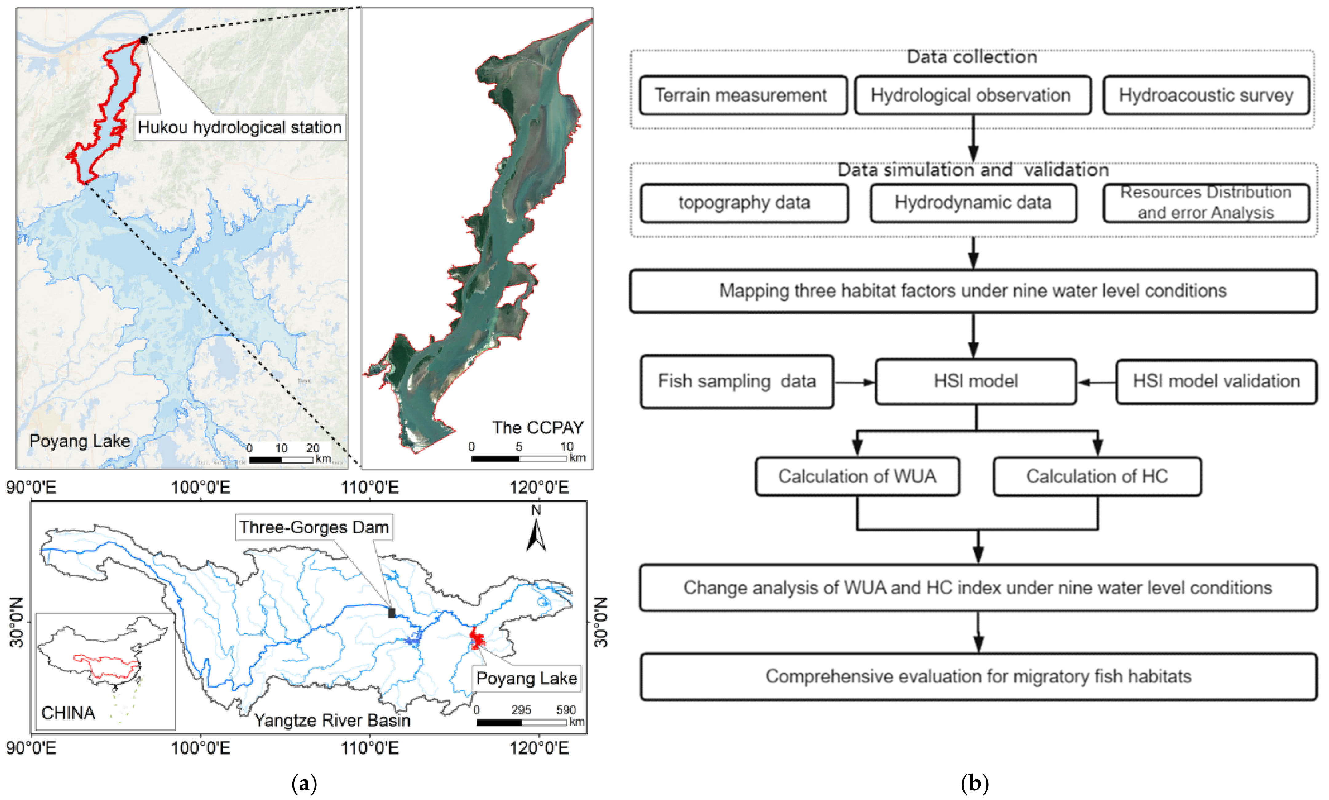
2.1. Study Area and Procedures

This study is focused on the north waterway of the Poyang Lake area (Figure 1), which lies in the middle of the Yangtze River (28°22′–29°45′ N and 115°47′–116°45′ E) region. Due to the subtropical monsoon climate, precipitation at the lake shows remarkable seasonality, resulting in the annual runoff changes of tributaries [31]. The entire lake area is geographically separated into two parts by Songmen Mountain: the southern part is the main lake with an extensive and shallow water surface, especially in the flooded season. In contrast, the northern part is a waterway connecting Poyang Lake and the Yangtze River with a narrow outlet at the Hukou, which is a necessary passage for the river–lake migratory fish [14], with a frequent exchange of material and energy between the river and the lake. The length of the CCPAY is 60 km, the width is 3–8 km, and the narrowest part is only 2.8 km wide [32]. Then, the water level increases in the water rising period from March to May, thus creating a large inundation area during the flood season from June to August. The maximum annual variation in the water level reaches 13.87 m (represented by the Hukou hydrological station). The monthly average water level is the highest in July, and the lowest is in January (which is only 8 m). According to statistics, the submerged area in the flood season is more than three times that of the dry season [33]. During the flood season, the extensive areas of water habitat in Poyang Lake attract migratory fish from the ocean and the Yangtze River, and the CCPAY becomes the busiest passage. Indeed, the difference in hydrological conditions from normal years has increased significantly in the latest decades owing to the impoundment of the Three Gorges Reservoir during this time, resulting in a steep drop in flood levels and an early dry season [34].
The research procedures can be summarized as follows (Figure 1b): First, the length interval of migratory fish in the study area was determined by the results of catch analyses, and the position of target strength in this interval was acquired by a hydroacoustic survey. Then, we simulated flow velocity and water depth characteristics using a three-dimensional hydrodynamic model under different water-level gradients and established the HSI model to quantitatively assess the habitat suitability for the FMCC during the migration period, including the area and the connectivity; the impacts of the WUA and HC index on the rising and receding rate of nine typical water levels were specifically described. Finally, we illustrated the possible ecological importance and implications of HC and proposed a comprehensive conservation strategy considering both the WUA and HC indices. An enhanced understanding of the dynamic changes in the connectivity of suitable habitats is beneficial for safeguarding the migratory fish population in the Yangtze River and the Poyang Lake basin.

2.2. Data Acquisition and Preprocessing

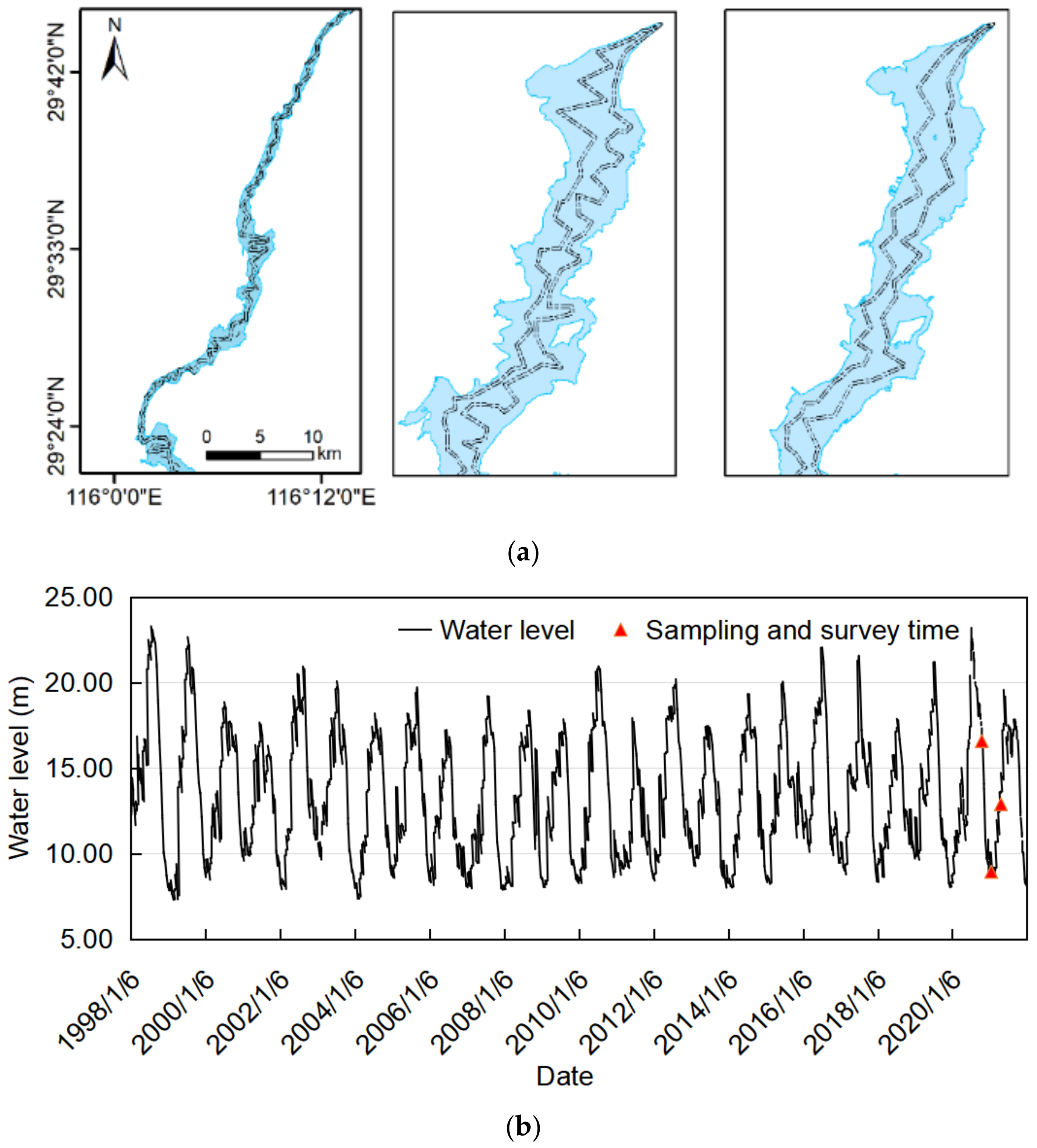
2.2.1. Field Data and Hydroacoustic Survey

In each sampling section, catches were obtained by fishing with various nets (20, 60, and 80 mm). Each evening (18:00–06:00), fixed gillnets that were 20 mm in size were deployed between 15 and 30 m offshore. During the daytime, from 6:00 to 18:00, drift nets that were 60 and 80 mm in size were employed in the deep-water area. Hydroacoustic data were collected from 1 to 3 September 2020, 15 to 18 January 2021, and 5 to 8 May 2021 combined with the catch surveying in various sections with different niches (such as backwaters, pools, etc.) using different types of nets (Figure S2a). The phylogenetic categorization of fish was completed as mentioned earlier [35]. Anesthesia was administered to the fish using MS-222 (SigmaAldrich Chemical Co., St. Louis, MO, USA), and each species’ body length was measured in millimeters. Fish species safeguarded by the Chinese government or on the list of the Convention on International Trade in Endangered Species of Wild Fauna and Flora were reintroduced back into the water. To avoid possibly confusing individuals, we removed those fish species with less than a 5% occurrence for further study, resulting in a fish sample dataset with 33 species for the following research (Figure S2b,c).
In this study, we conducted hydroacoustic surveys during October 2020, January 2021, and April 2021, along with different water level periods (Figure 2) in the CCPAY using a calibrated SIMRAD EY60 system. The system’s working power was 300 W, its pulse width was 64 μs, and its transducer frequency was 200 kHz with an angle of 7° at −3 dB. The transducer was installed on the front of the boat at a depth of 0.5 m under the water surface [36], with a navigation speed of 8–10 km/h. The GPS data were gathered using a GPS receiver (Garmin, Taiwan, China), and the instrument was calibrated using a tungsten–copper metal ball with a diameter of 13.7 mm before starting the investigation (Figure S2d) [27]. The degree of coverage values for each study was determined using Formula (1) [37], in which Λ is the coverage value; L represents the total length of acoustic transects; and A is the studied area. The results varied from 7.05 to 22.37. These coverage values were above the minimum recommendations noted in the literature [38,39].
Λ = D / A
TS = 23.97 log L − 103.90
According to the calculation empirical Formula (2) [40], L represent total length in mm, and for a 450 mm fish it gives TS = −40.30 dB. Hydroacoustic data were converted and analyzed by Sonar5-Pro software (Simrad, University of Oslo, Oslo, Norway), with the surface line set to 0.8 m and the line below set to 1 m above the river bottom. The practical processing steps of the method to determine the targets can be summarized as follows: (I) For the file conversion, the converter in Sonar5-Pro transformed the raw documents (.raw) into .uuu documents. (II) For river bottom detection, the bottom detector identified every file’s riverbed bottom line (image analysis detector). Manual rectification was carried out to optimize the detector’s river bottom line. (III) For target tracking, a multiple target tracker (MTT) was used with appropriate parameter settings to identify the target. (IV) For track filtering, we only chose targets related to fish lengths of >450 mm to match the catching data based on the fish size distribution obtained acoustically. The track filtering parameters were set as follows: the number of echoes ≥4, maximum ping gap = 2 pings, gating range = 0.3 m. (V) The target was obtained as described above, and then the position and target strength (TS) information was exported for subsequent analysis. The target location data in the CCPAY under the representative water levels from 2020 to 2021 are shown in Figure 2. The additional material gave a sum of 335 positional data (Table 1).

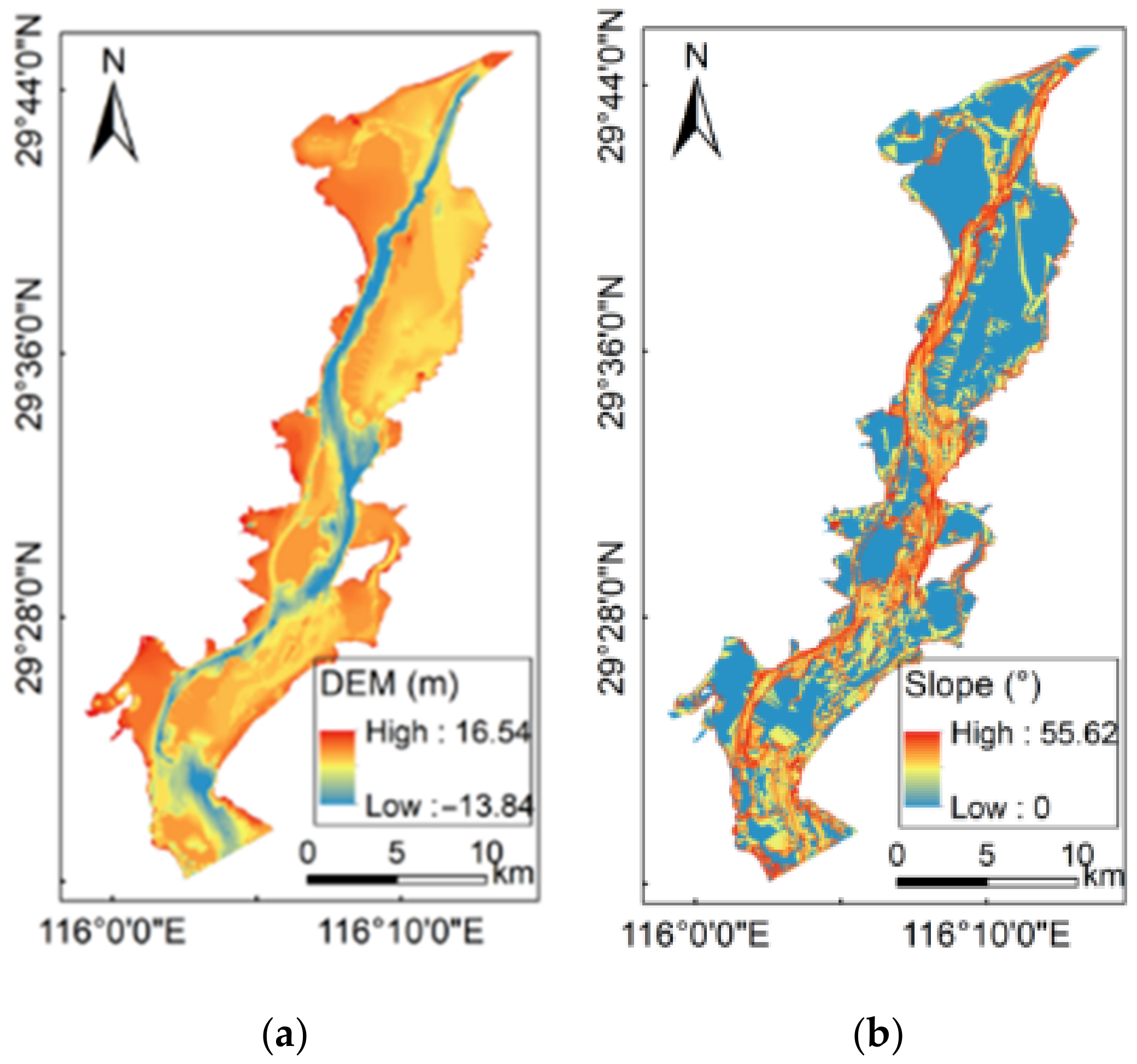
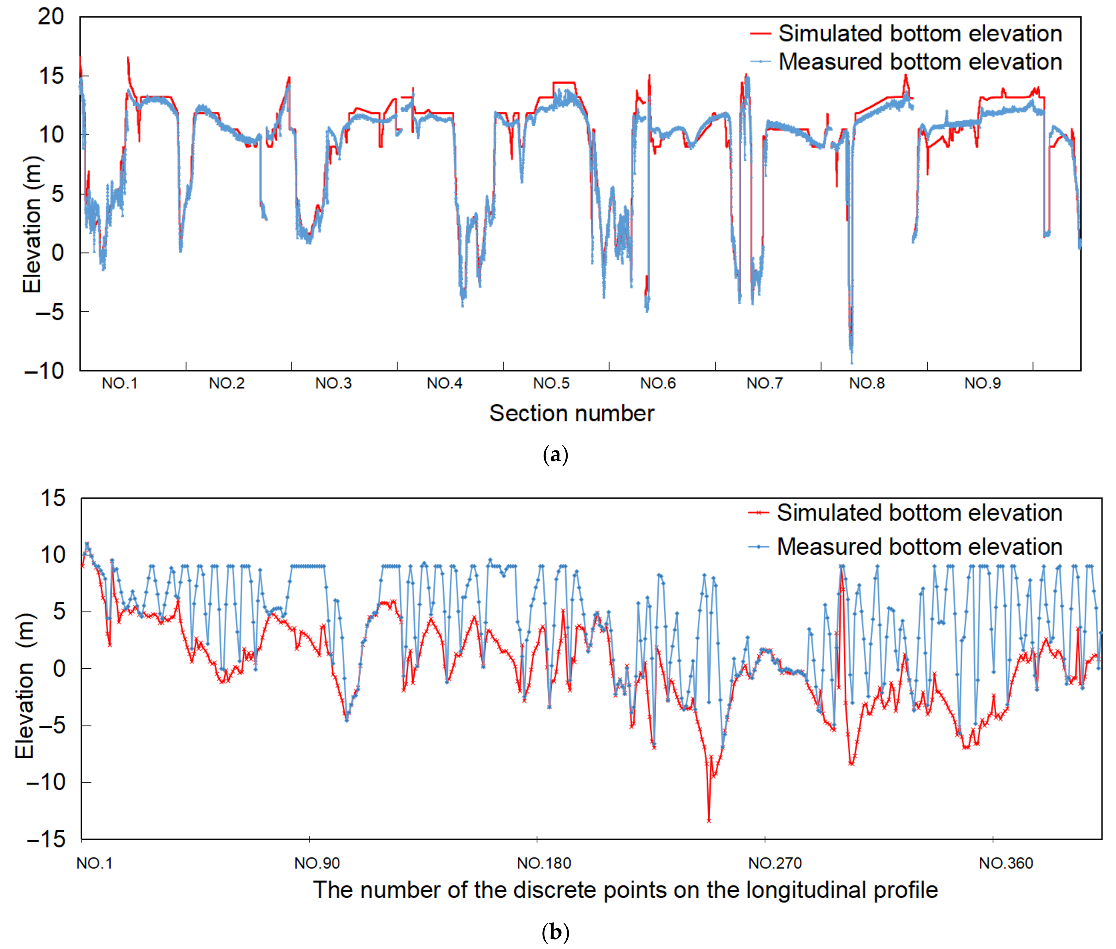
2.2.2. Lake Bathymetry Simulation

The lake bathymetry distribution simulation of CCPAY is mainly based on: (1) RADARSAT-2 satellite data (https://www.asc-csa.gc.ca/eng/satellites/radarsat2/) (accessed on 6 January 2018) with a spatial resolution of 30 m acquired from 2012 to 2014; (2) lake bottom elevation data measured by a ship-borne dual-frequency echo sounder (Bathy-500) synchronized with the satellite data, in which 60 sections were set along the channel and the measuring points were placed every 2 m across each section (Figures S1b, S2e, and S3) water-level data during the topographic survey (http://www.cjh.com.cn/) (accessed on 10 May 2020). The following are the specific steps for the lake bathymetry distribution simulation of CCPAY [41]: (I) The representative remote sensing images of the typical water level were acquired, and the water–land boundary line for each image was extracted. (II) The bottom elevation along the water–land boundary line derived from each RADARSAT-2 image and the corresponding water-level data on that day were projected to a reference surface to obtain a contour line [42]. Then, the contour line was discretized and converted to elevation points at the lake bottom with a 5 m distance interval by using ArcGIS 10.2 software. For the region within the smallest water–land boundary, kriging spatial interpolation was carried out first using the measured elevation data; then, the line-to-point conversion was also carried out according to the 5 m distance interval after the interpolation results were generated. Since there was no obvious latitude spatial gradient in the water level from Hukou to Duchang on the day the image was acquired (Table S2), there was no need to perform the latitude correction for these discrete lake bottom elevation points [42]. (III) For the CCPAY, kriging interpolation with a spatial resolution of 5 m was carried out for a second time with all elevation point data to obtain the digital DEM data (Figure 3a). Using these DEM data, the topographic slope of the lake bottom was calculated by ArcGIS 10.2 (Figure 3b).

2.2.3. Hydrological Data and the Three-Dimensional Hydrodynamic Simulation

The daily hydrological data used for hydrodynamic simulation came from the Hukou gauging station (data from Hubei Province’s Hydrological Bureau’s routine monitoring, Wuhan, China, www.cjh.com.cn, Figure 1) (accessed on 10 May 2020). All hydrological data were calibrated based on the elevation reference of Woosung Horizontal Zero. Firstly, the spatial and time ranges for the three-dimensional hydrodynamic simulation should be identified. The spatial range of the CCPAY for the hydrodynamic simulation was determined by the maximum flood range in the flood season [43]. Since the water level at the Hukou hydrological station has a significant variation during the investigation period, considering the timeliness of hydroacoustic data and the comparability of the data, the time frame within which all this simulation was conducted was from August 2020 to August 2021 for facilitating the data’s statistics. Secondly, the constructed topographic file grid was divided into 280,000 units as input data for the hydrodynamic simulation, and the size of the computational element was 30 m. After preparing all the input data, we finally established the three-dimensional hydrodynamic model using the EFDC (the Environmental Fluid Dynamics Code, EFDC Explorer 7.1) and simulated the hydrologic processes with the multiyear hydrological data when analyzing water-level gradients for 8, 10, 12, 14, 16, 18, 20, and 24 m which represented the water-level distribution characteristics of the CCPAY (the “typical water-level” is actually the segmentation of water level). We analyzed the water level data of Hukou from the past 30 years, which was obtained from the official website released by the Hukou Hydrological Station (Figure 2b). Then, we divided the water level according to the gradient at an interval of every 2 m. The simulation map was interpolated using the kriging interpolation method and eventually resampled to a resolution of 30 m (Figure S3).

2.3. Calculation of the WUA and HC

Firstly, the Habitat utilization method was used to determine the habitat suitability curve, which is mainly based on the measured frequency distribution of micro-habitat characteristics and is directly derived from the habitat use of the target species at specific life stages [44,45]. Then, an HSI function was established in consideration of the habitat characteristics of the FMCC [26], followed by calculation of the WUA to quantify the suitable habitat for a target species at a specific water condition [22]. Additionally, the connectivity of the effective suitable habitat (HC) under specific water-level conditions was selected and calculated. Finally, the WUA and HC were synthesized to evaluate the quality of the migration habitat under different water-level conditions. A geometric mean was utilized rather than an arithmetic mean since it provided a more conservative assessment of the habitat [46]. To satisfy the suitable living environment of fish as much as possible, the combined suitability index should be greater than 0.5 [47]. Detailed formulas are described below:
H S I i = I V i I D i I S i 1 3
W U A = i = 1 n A i H S I i
H C = i = 1 m j = k n C i j k i = 1 m n i n i 1 2 100
Corresponding to Formulas (3)–(5), HSIi is the corresponding habitat suitability index of the ith grid cell; i represents the order number of the grid cell; IVi, IDi, and ISi represent the ith grid cell’s suitability value of the velocity, depth, and topographic slope, respectively; Ai (m2) is the area of grid cell i; WUA is calculated by the geographic information system (GIS, ArcMap 10.2) under a series of water levels.
In Formula (4), HC is the sum of the number of functional connections between all effective habitat patches (sum of Cijk where Cijk = 0 if patches j and k are not within the specified distance of each other and Cijk = 1 if patches j and k are within the specified distance) [48], divided by the total number of possible links between all effective habitat patches multiplied by 100 to convert the figure to a percentage, with a range from 0 to 100. Cijk is the sum of connections between effective patches for a given threshold condition; ni represents the number of effective habitat patches in the landscape of each patch type (i). The habitat patches with HSI ≥ 0.5 were extracted and taken as the research objects to calculate connectivity. As migratory fish, a higher sustained swimming ability [49] is important for long-distance migration. Since bighead carp is the dominant migratory fish in the CCPAY, the critical swimming index of bighead carp’s laboratory temperature was taken as the typical index of migratory fish in the CCPAY. Considering their mean relative critical swimming speed is 77.55 cm/s [50], and the mean endurance time is generally about 7 min [51], the distance threshold of connectivity was set to 500 m in this study. Moreover, the novel connectivity indices on the habitat were calculated using VecLI 3.0.0 software [48]. It needs to be further explained that the water level standardization of change rate is carried out for the lateral comparison in Section 3.3.

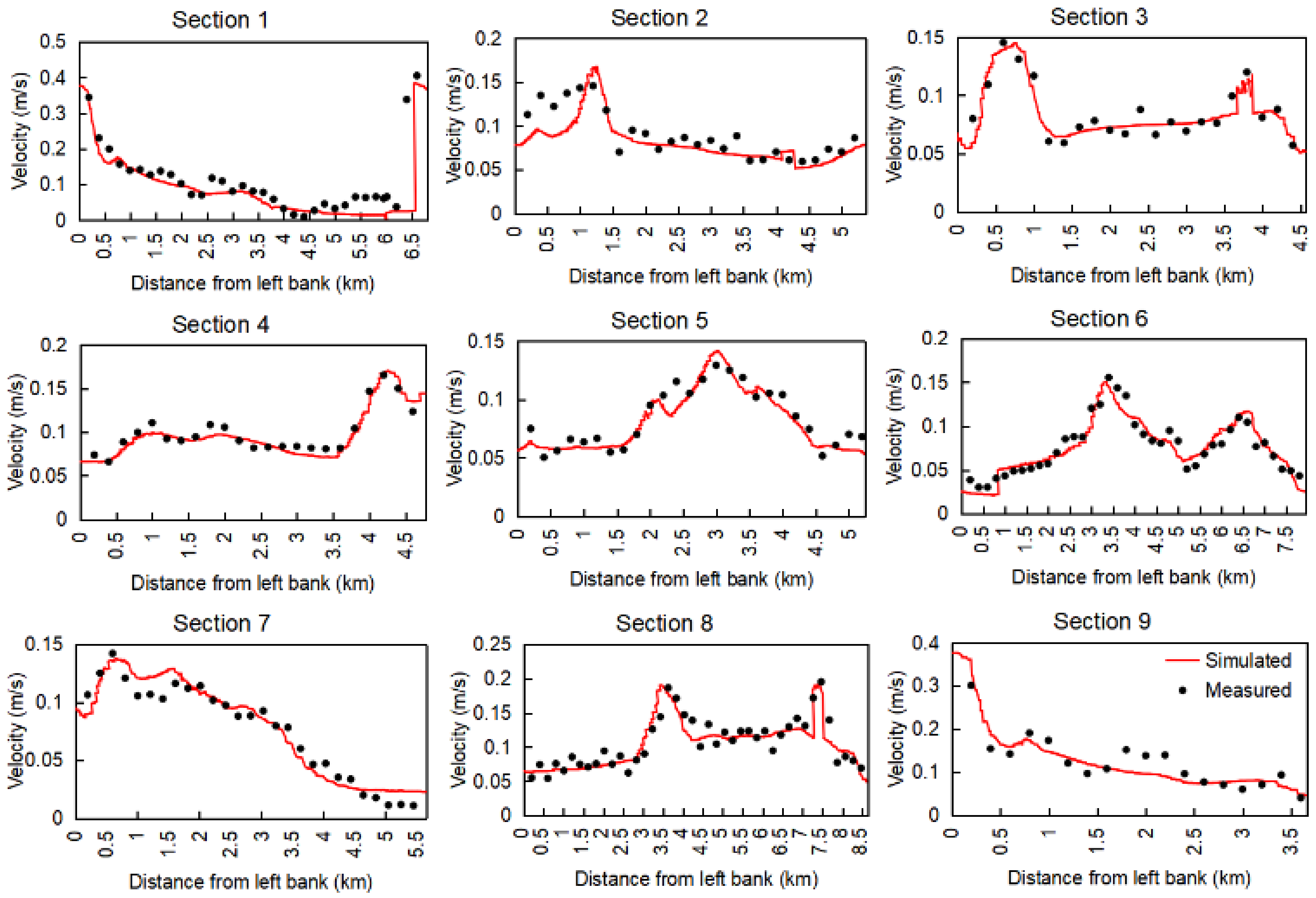
2.4. Error Source Analysis and Accuracy Validation

For hydroacoustic detection, the waves, ship operation, aquatic vegetation, and other external environmental interference may affect the accuracy of the estimation of the population number and body length of the fish [52]. To address these problems, we firstly chose sunny and windless weather for the investigation to avoid the impact of bubbles and suspended sediment caused by wind, waves, and rain in order to minimize the error of the hydroacoustic data [53]. Secondly, the coverage of aquatic vegetation in the study area is low [43], and the water depth along the survey route reaches 4.8–28 m under different water-level conditions. Therefore, the interference of aquatic vegetation and sediment on the detection signal should be small. Nevertheless, random errors caused by less investigation frequency may still exist. In the future, the investigation frequency of a single season will be further increased to verify the results of this study more carefully.
The horizontal elevation accuracy (Figure 4a) and longitudinal topographic continuity (Figure 4b) in the CCPAY were verified for the lake bathymetry simulation. The topographic simulation results not only had a firm consistency with the measured elevation data in the horizontal direction along each section (Figure 4a) but also showed good continuity and smoothness in the longitudinal direction perpendicular to each section. In contrast, the longitudinal terrain formed by only connecting the measured elevation points was erratic and lacked detail (Figure 4b). Therefore, the simulated lake bathymetry data were used for subsequent research.
For three-dimensional hydrodynamic modeling, the velocity of the cross-section in the research area was used to calibrate and verify the model. The current velocity of nine cross-sections was measured using a current velocity meter (Model LJD3, Chongqing, China, Current Velocity Meters Inc.) in the CCPAY on 15 July 2020 (Figure S1c), and the comparison results across the simulated and measured depth-averaged velocity proved that the EFDC model was capable of simulating the dynamic hydrologic characteristics (Figure 5).
In our study area, most of the bottom habitat type is dominated by sandy sediments. The types of sediments change little spatially, while the terrain changes significantly, so we chose to ignore the influence of sediment. However, we do consider the impact of the topographic slope on fish distribution as well as other ecological factors linked with the flow such as velocity and water depth, which were key determinants for migratory fish HSI research [28,54]. Due to different research focuses [55], other crucial factors such as water temperature, pH, electrical conductivity, and water quality parameters (COD, potassium permanganate index, BOD_5, etc.) were not taken into account in our study.

3. Results

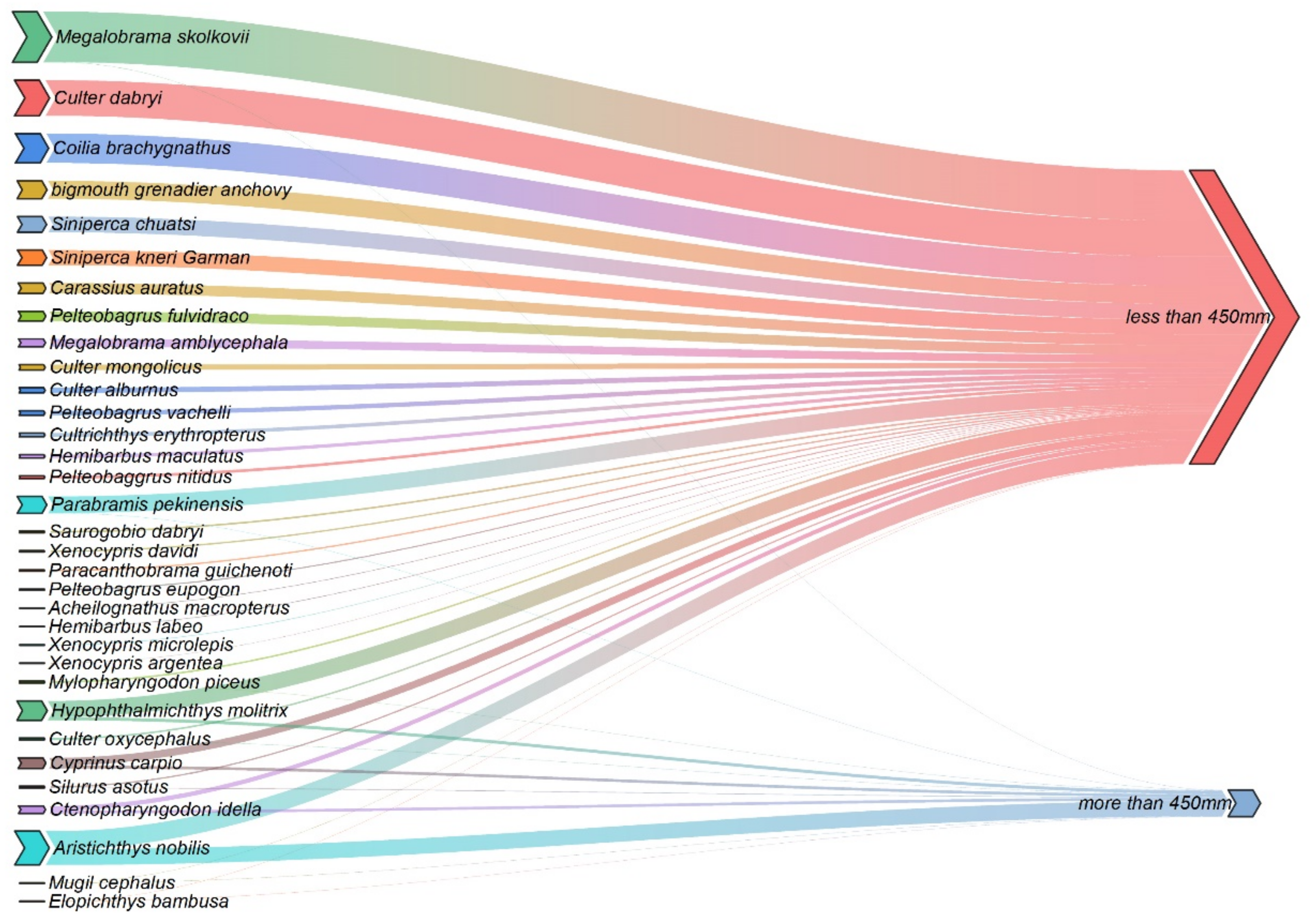
3.1. Fishery Resources

There were 33 different fish species collected, totaling 1030 fish, of which there were 11 species and 97 fish with a total length of more than 450 mm (Figure 6). Among them, bighead carp and silver carp were the most numerous, accounting for 58.51% and 11.7%, respectively. The FMCC accounted for 81.91% of the population which is larger than 450 mm in body length. According to the calculation in Section 2.2.1, the target strength corresponding to 450 mm is about −40.30 dB, so a signal greater than −40.30 dB can be judged as the FMCC. Therefore, the fish with a total length of more than 450 mm were selected for location extraction in the hydroacoustic analysis.

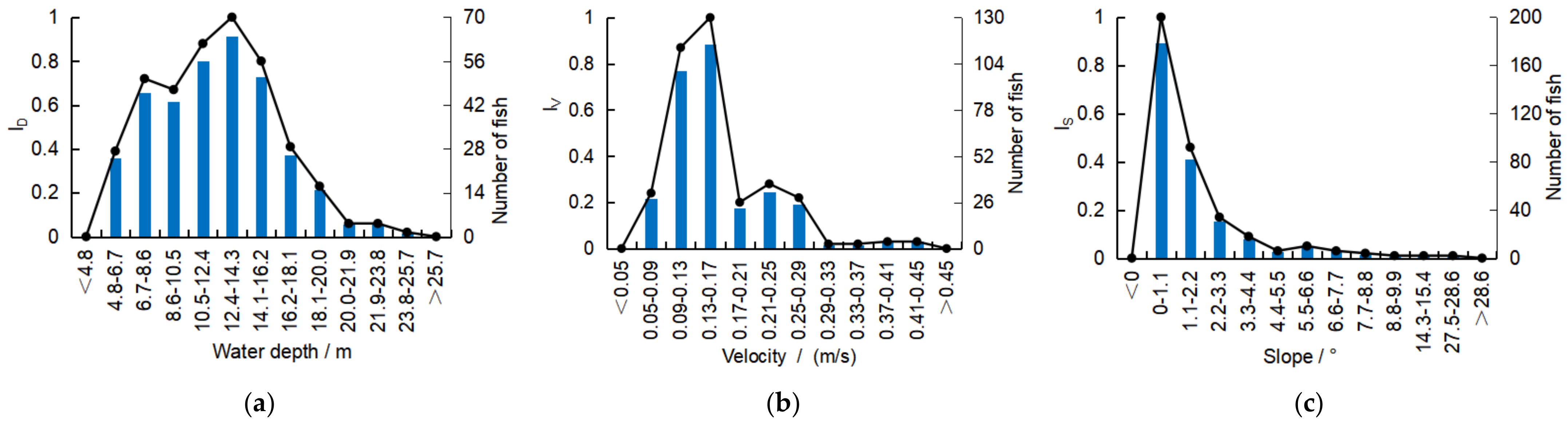
3.2. Habitat Suitability Index Curves

The maximum normalized ID, IV, and IS histograms are shown in Figure 7, which were obtained based on the statistics of typical point hydraulic values obtained at the same time as the hydroacoustic surveys during 2020–2021.
The suitable water depth range (ID ≥ 0.5) for migrating fish was 6.71–16.21 m. The ID reached 1 when the depth was between 12.41 and 14.31 m, indicating the optimal range of water depth. The suitable velocity range (IV ≥ 0.5) was 0.093–0.173 m/s. Additionally, at a velocity of 0.133–0.173 m/s, the IV reached 1, indicating the optimum velocity for migrating. The best topographic slope suitability for migrating is 0–1.1°.

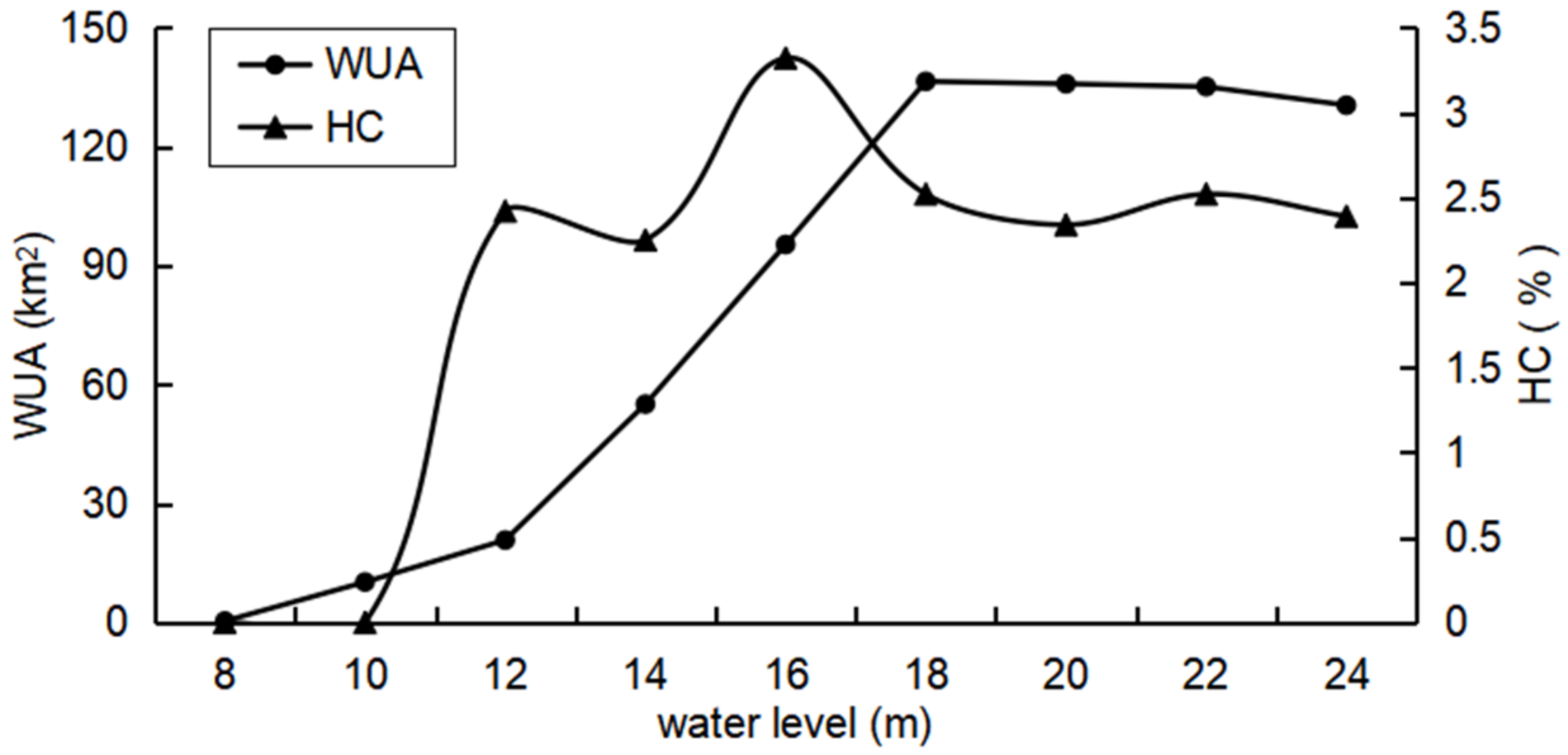
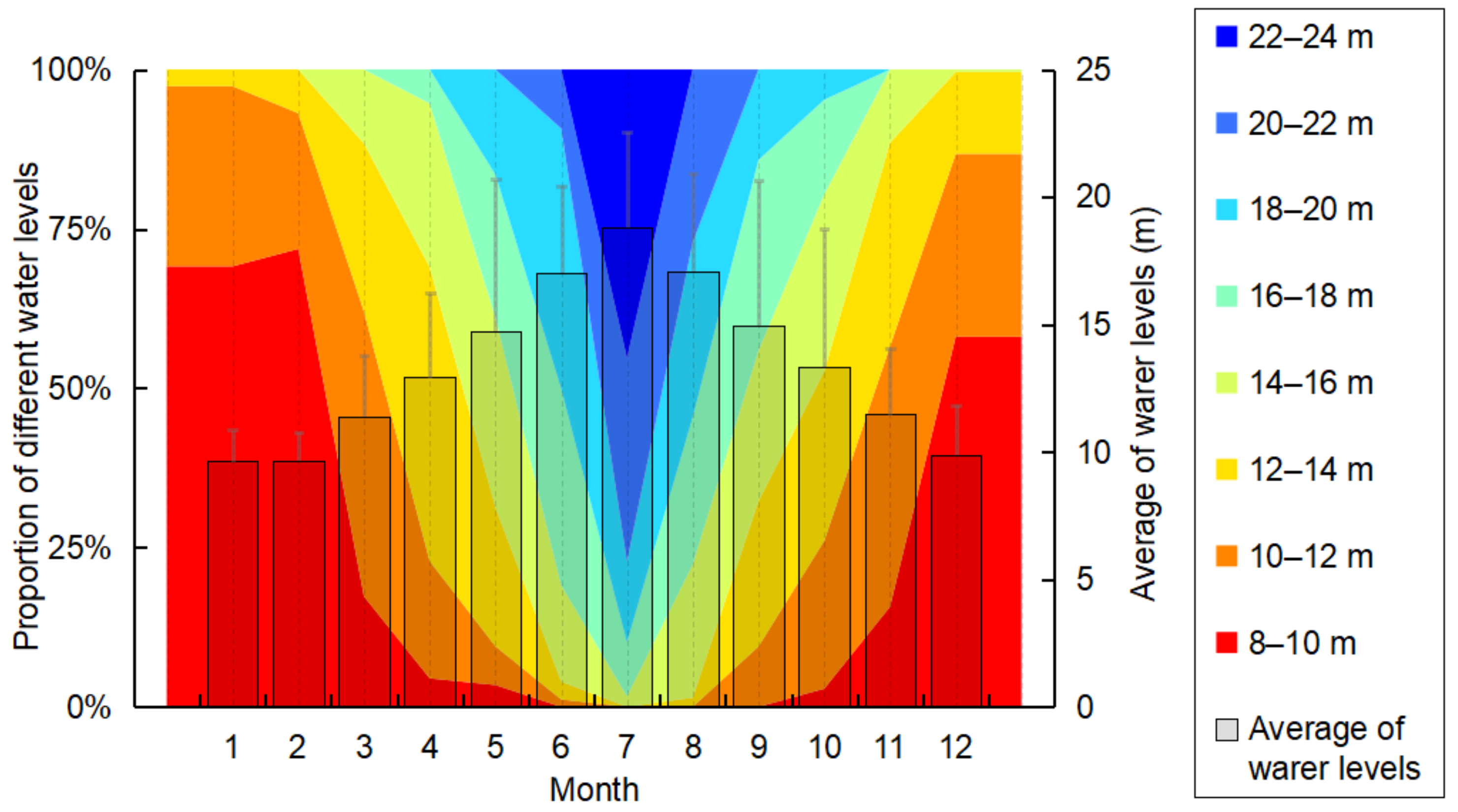
3.3. Effects of Water Level on the WUA and HC

Figure 8 shows the habitat suitability distribution maps. With the increase in water levels, the suitable habitat distribution extended gradually from the center of the river to the banks on both sides. Moreover, the water depth and velocity increased in the central channel when the water level was more than 20 m; the suitability of the main channel decreased, and the most suitable habitats were mainly distributed near the banks on both sides of the river. Table S3 shows the area of the suitable habitat (HSI ≥ 0.5) under different water level conditions. A total of 47.8% of the study area became suitable habitat at the high-water level of 20 m. In contrast, for the case of an extremely low water level (8 m), there were only a few suitable areas. Thus, at least 47.8% of the study area experienced a tremendous exchange of suitable–unsuitable events within a year, which implicated a dramatic annual spatial heterogeneity of the hydrological changes and habitat dynamics in the CCPAY.
Figure 9 shows the WUA changes under different water-level stages. It is obvious that when the water level was lower than 18 m, the WUA for the FMCC habitats increased significantly, and then decreased gradually after the water level reached 18 m. There was little WUA when the water level was at its historically lowest level of 8 m. When the water level was at the stages of 8–12 m, the WUA increased slowly at the rate of 10.21 km2/m. When the water level was between 12 and 18 m, the increasing rate of WUA became the greatest (57.81 km2/m), indicating that the migratory fish may be more sensitive to the water level under the condition of 12–18 m. When the water level was between 18 and 24 m, the WUA attenuated slightly with an average rate of −3 km2/m, indicating that the continuous increase in the water level at the high-water level stage may have a negative impact on fish habitats.
Referring to the relevant results, the water-level conditions corresponding to the turning point of the first stage with a rapid rise in the WUA–water level relationship curve were selected as the minimum ecological water-level conditions [56]. At this time, the habitats were greatly affected by the water-level conditions. Additionally, in principle, it was required that the WUA under the appropriate water-level conditions was not less than 50% of the maximum habitat area [22]. In this case, considering WUA maximization, the optimum ecological water-level conditions were above 16 m.
It can be seen from Figure 9 HC that in the process of the water level moving from low to high, the curve of the connectivity increased with the fluctuation. Overall, when a water level of 10–16 m undergoes a sudden rise in connectivity from zero to the maximum, it can be seen that the FMCC are more sensitive to this interval from the value of habitat connectivity. The HC curve appears at the first local peaks with an HC value of 2.42%, which means the water level at 12 m is the lowest threshold for river–lake connectivity. As the water level increases further to 14 m, the floodplain expands but with a negative growth rate −0.09% per meter. When the water level reaches around 16 m, the HC reaches its highest peak with a large area of connected and increased river center patches, and the growth rate is 0.54% per meter. However, while the water level is between 16–24 m, there is a decreasing trend of the HC with average growth rate −0.11% per meter. With the increase in water level and the expansion of flow, the habitat mainly appears in the two riparian beaches. Habitat patches are mostly scattered with poor integrity. In this case, considering HC and WUA maximization, the optimum water-level conditions are above 16 m.

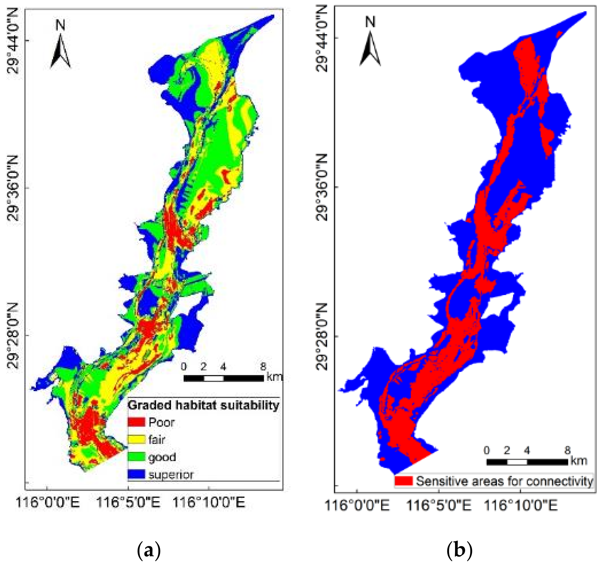
3.4. Mapping the Graded Habitat Suitability and the ECA Distribution

For the graded habitat suitability, the results of the HSI under different water levels were superimposed, and the superposition results were divided into four levels using the Jenks natural breakpoint method, i.e., poor, fair, good, and superior (also called the ecological core area, ECA) (Figure 10a). The ECA is the main habitat patch (mainly located in Laoyemiao, Xingzi, and Pinging), and it is also the ecological source of the ecological network. The other habitats are all expanded outward based on this which can provide larger migratory habitat areas for species and are important for biological migration and landscape connectivity.
Considering that connectivity is essential for fish migration, the protected area should be divided more carefully by adding HC. Since there is a sudden rise in HC once the level of water is between 10 and 16 m, and the connectivity grows from zero to the maximum mentioned above (Figure 9); this indicates that the FMCC are more sensitive to the HC at this interval. The red area in Figure 10b is an extremely sensitive area with higher potential connectivity; it is a narrow core area that is a corridor connecting the main habitat patches, and it needs to be protected to ensure connectivity, which is essential for CCPAY to provide an important function as a fish migration corridor.

4. Discussion

4.1. The Habitat Suitability Index

It is well known that, in most cases, the habitat suitability membership function is derived from a laboratory flume [47]. Laboratory experiments, on the other hand, are insufficient to imitate the behavior of fish in natural environments. Hydroacoustic technology was used to track the natural movement of fish in the field, which was crucial for studying fish preferences [57,58].
The fish captured were taken as the data source to make a distribution map of FMCC, and this distribution map was then superimposed with the coetaneous HSI at a water level of 16 m in the autumn of 2021. The suitability curves in Attached Figure 4 could properly represent the FMCC’s hydraulic preferences for their habitat. The HSI model, which was based on our research’s suitability curves, was typically successful in identifying the FMCC’s effective habitat; however, the coverage of catch sampling points is not sufficiently comprehensive, and increasing sampling points could further verify the model.

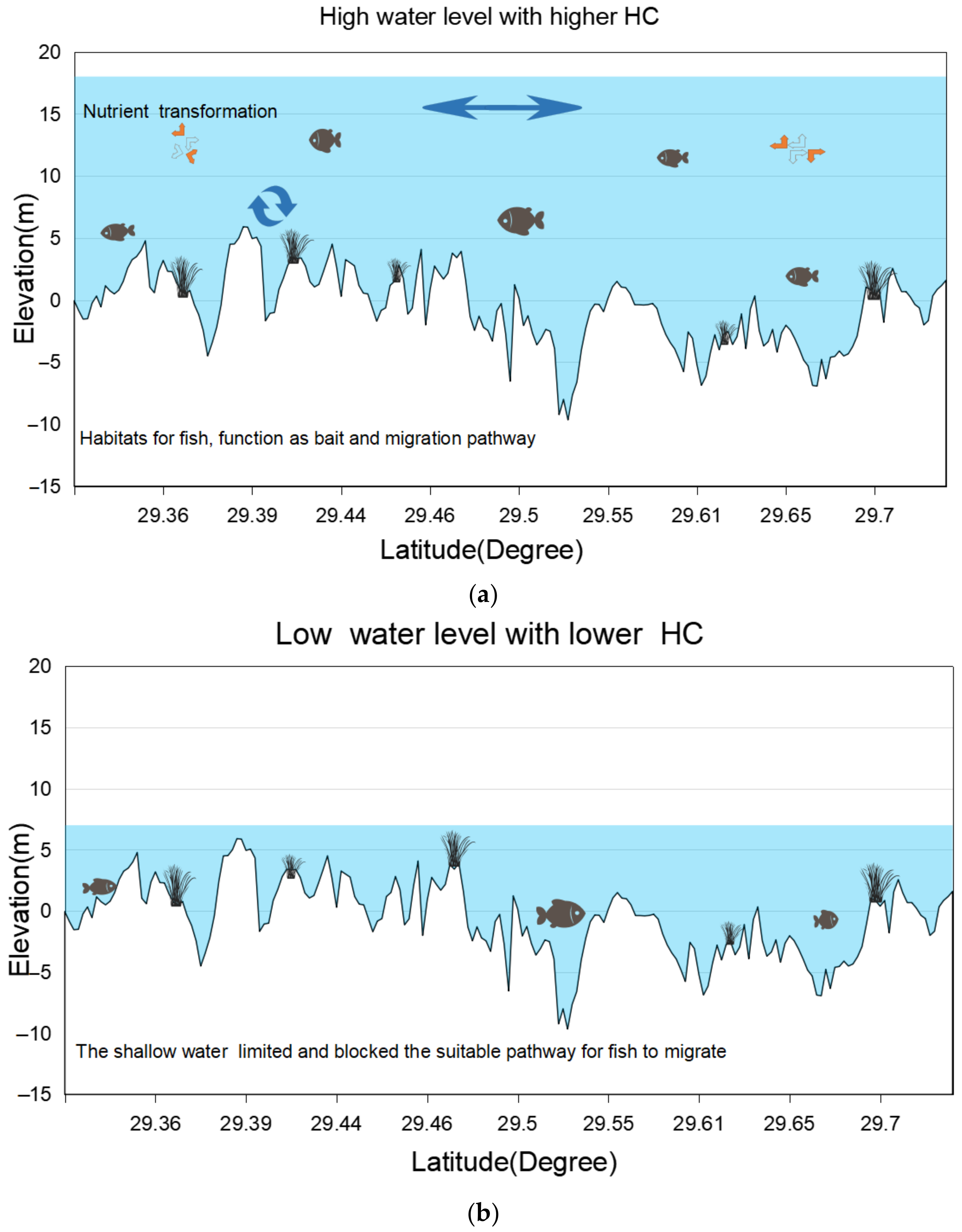
4.2. Effects of Hydrologic Changes on the WUA and HC

The connectivity of migration pathways is the most critical factor in the process of fish migration, because the area of the suitable habitat determines the quality of WUA utilization in the migration period of fish. Some earlier studies have attempted to explore the relationship between hydrological connectivity and wetland function. For example, a geospatial analysis was used to estimate groundwater connectivity by relying on wet/dry binary condition data produced from combined images. Xia et al. [59] explored the different effects of connectivity with varying types of hydrological controls on Poyang Lake by using field observations of waterbirds and habitat maps collected from satellite data for Poyang Lake. Although prior research has emphasized, the importance of hydrological connectivity on the plant, birds, and water quality of Poyang Lake [19,31,59,60] as well as the water depth, velocity, and slope have not been quantitatively coupled to explain the ecological influence of habitat connectivity. The level of communication under specific spaces and the relationship between environmental factors are essential in the study of habitat connectivity. As a result, habitat connectivity should be evaluated with biological and ecological dynamics.
Poyang Lake serves as an essential habitat site for migratory fish [19], and the CCPAY has been recognized as a critical stopover area on the migration path of the FMCC [60]; it is extremely important for migrating fish (Figure 11). Among the various environmental factors that contribute to fish stocks, the HC is critical because it significantly impacts hydrodynamics [61] and habitat environments [25]. A higher HC is likely to help with nutrient transport and biota migration in freshwater systems during high water levels [2,62]. Isolated pools, which are detached from the river system under low water conditions, maintain a rather lifeless water habitat that is detrimental to migratory fish (Figure 11). Additionally, the sensitive habitat areas (Figure 10b) were subject to frequent exposure, which is detrimental to habitat connectivity and aquatic biota survival. Liu et al. (2016) explored the responses to lateral hydrological connectivity on the diversity of fish assemblages using generalized linear mixed models [11]. The findings revealed a severe decline in the functional richness of fish and that fish diversity is extremely sensitive to a decrease in hydrological connectivity even in such a species-rich ecosystem in the large floodplain area of the Yangtze River. Penha et al. (2017) revealed that lakes that are permanently connected have more fish biodiversity than disconnected lakes [63]. The research also proves that rivers with more natural connectivity have higher fish diversity and abundance [64]. Therefore, our research results in Section 3.3 are consistent with these studies: low water level decreases the HC and is not conducive to the increase in suitable habitats for fish. In contrast, a medium to high water level is beneficial for maintaining the high WUA and HC.
The characteristics of HC are different under various water levels, and thus have a significant impact on Poyang Lake’s ecological quality [65]. As is shown in the results, water levels above 16 m have medium-to-high values of HC (Figure 10). Wang et al. (2016) [66] found that aquatic organisms (biomass and biodiversity) reach a maximum at one stable river connectivity index. Compared to the lower water level in the CCPAY, the higher water level shows superior connectivity in suitable habitats (Figure 11). Furthermore, the HC of the water level influences the initiation and duration of the migration time. As for the migration time under low water levels (near July to November), the peak migration time has a later start, and there is a shorter migration period, reduced quality, and an impact on the supplement of fish resources compared to those of medium or higher water levels [61]. Consequently, maintaining medium-to-high connectivity during the peak period of migration is very important to the replenishment of fish resources in Poyang Lake and even the whole lake’s ecological cycle.
The extremely dry season, early dry season, and prolonged dry season have gained much more attention from researchers because of their possible effects on the ecosystem of Poyang Lake. Moreover, the state of the water quality is much worse in dry periods than flood periods for the whole of Poyang Lake, and the lower water level tends to isolate the lakes from the main river, leading to the deterioration of water quality, and finally, to the reduction and destruction of fish habitats [25,67]. The results in Section 3.3 show that the WUA area occupied over 40% of the total area when the water level was over 18 m and occupied less than 2% of the total area when the water level was below 10 m (Table S3). According to Wang et al. [10], one of the major issues the Yangtze River floodplain faces is that most floodplain lakes are isolated from the river system. In our research, when the lake level dropped below 10 m, most suitable habitat patches were cut off from the river system, which obstructed nutrient movement and dilution, and finally reduced and blocked the connectivity of the fish migration path [67,68].

4.3. Implications for Management and Conservation

Spatial and temporal measures that focus on the environmental restoration of rivers and biodiversity conservation should be taken to increase the quantity and quality of suitable migration habitats in the CCPAY [69].

4.3.1. Adjusting Reservoir Management

The first step to provide suitable water levels during the peak time of FMCC migration is to adjust reservoir management. According to historical records, the migration period of FMCC was from April to November when the water level fluctuated between 8 and 24 m in the CCPAY [70]. However, the water level affects the condition of the FMCC’s migration pathway [58]. As shown in Figure 12, the average water level in June to August is the highest, and the average water level in November to March is lower than 12 m. The monthly fluctuation ranges from May to October are the largest, having a great influence on the connectivity of the fish migration pathway. The occurrence frequency of water levels less than 16 m is more than 45% in April. Moreover, the peak period of fish migration is from July to August (river to the lake) and September to November (lake to the river), and the frequency of water levels above 16 m is 20.30% in July and August. During September to November, the water level changes greatly (Figure 12), and the frequency of days with a low water level is 40.31%. At the same time, the occurrence frequency of water levels that are less than 12 m in December and March is more than 30% in the dry season, which leads to a large number of FMCC being blocked in the CCPAY to some extent, leading to fish overwintering in the Yangtze River and resulting in decreased fish resources.
The development of water conservation projects alters the hydrology’s natural fluctuation, affecting factors such as the timing of the dry season and the duration of high-water periods [19]. These changes impact the quality and quantity of fish habitat. Studies have shown that managing water levels at an appropriate level improves the capabilities of habitats [71]. Therefore, the reservoir group upstream from the Poyang Lake water system and the Three Gorges Dam can be used to regulate the water levels of the Yangtze River, and it is recommended that the minimum water level should be maintained above 12 m in the low-water period to ensure the minimum connectivity is obtained. The water level should be above 16 m and kept stable in the peak migration period (July–November), to meet the migratory demands of the FMCC and ensure the quality of the migratory habitat.

4.3.2. Conservation Area and Recommendations

Subregional control should be implemented according to the classification of the conservation area (Figure 10). Shipping should be reduced during the peak migration period in the ECA region. For highly sensitive areas, if high-intensity human activities such as sand mining and hydraulic construction are carried out, they will have an irreversible impact on and directly reduce the permeability between the patches of the suitable habitats, leading to the permanent obstruction and reduction of the migratory habitat. To maintain the connectivity of habitat patches in highly sensitive areas, we recommend the following measures: remove the dams, especially those that exist in sensitive areas and restore the natural bottom topography that was destroyed by channelization, the excavation of sand, agriculture, or urbanization.

4.4. Data Limitations and Innovations

This study only simulated the water level under nine water level conditions with an average interval of just 2 m, which limits the spatial and temporal resolution of the habitat connectivity analysis, owing to weak calculation ability. Future research needs to increase the number of simulation conditions to enhance the accuracy of the model. Altered hydrological parameters such as water depth and velocity impact the effective suitable habitat connectivity in our study. However, the factors we discussed are not the only restricting factors: the suitable habitat is also related to prey availability after a change in the hydrological regime, which is the focus of our subsequent study.
Despite these limitations, there are two innovations in this research. The first innovation of this article is the interdisciplinary application of Geosciences and fish resources. The possible impacts of the water level change on migratory fish habitats remain unclear due to the limitation of traditional techniques in spatio-temporal analysis. In this study, we combined remote sensing technology, three-dimensional hydrodynamic modeling and fish hydroacoustic technology to build the habitat suitability index, which could improve the possibility of quantitative analysis of habitat change in complex systems. The second issue addressed in the paper was the exploration of the impact of connectivity on fish habitat by innovating new composite indicators. To perform a comprehensive evaluation of migratory fish habitats’ ecological functions in the study area, the concept of connectivity is introduced into the weighted usable area (WUA) to meet the requirements for the quantitative analysis of the habitat demands of migratory fish. This work is a valuable contribution to understanding the carp migration process between two key habitats.

5. Conclusions

As the only outlet of Poyang Lake flowing into the Yangtze River, CCPAY is an important ecological channel for a variety of migratory fish to complete their life history. Ensuring the habitat suitability and its connectivity is crucial for the conservation of fish and maintenance of the diversity of fish resources in the middle and lower reaches of the Yangtze River. It is also essential to maintain the sustainable development of the large river–lake system. This article aims to expand on the existing knowledge of the migratory habitats’ distinctive hydrological conditions and ecological effects. Overall, the negative effect of a low-water level is greater than a high-water level in regards to the WUA and HC. The sensitive areas with a water level of 10–16 m were determined by the WUA and HC. We recommended that the minimum water level should be maintained above 12 m in the low-water period to ensure the minimum connectivity. The water level should be above 16 m and kept stable in the peak migration period (July–November) to meet the migratory demands of the FMCC and ensure the quality of the migratory habitat. Conservation areas need to be established to maintain the connectivity of habitat patches in highly sensitive areas.

Supplementary Materials

The following supporting information can be downloaded at: https://www.mdpi.com/article/10.3390/w14132076/s1, Table S1: Summary of hydroacoustic data for the four major Chinese carps during three typical water conditions. (Only show a part of the low water level period in Table 1. See the attached Table S1 for the full details); Table S2: 30 m resolution remote sensing data and corresponding water level conditions in the study; Table S3: The proportion of suitable habitat in the total area of the study area; Figure S1: (a) Sampling points of the catches. (b) Map of the navigation route during bathymetry survey in the CCPAY. (c) Map of nine verification sections of simulated depth-averaged velocity; Figure S2: Pictures of field investigation. (a) Lake scenery. (b) Main fish species. (c) Fish collection. (d) Hydroacoustic survey. (e) Data acquisition and processing of lake-bottom topography; Figure S3: Simulated average water depth (a) and velocity (b) under nine water levels in the CCPAY; Figure S4: Validation of the HSI map under the water level of 16 m using field surveys simultaneously.

Author Contributions

Conceptualization, D.C., L.W. and H.Z.; Data curation, H.L. and L.Y.; Formal analysis, H.L., H.Z. and X.D.; Funding acquisition, D.W. and S.L.; Investigation, L.Y., K.C. and F.D.; Methodology, L.W. and H.L.; Project administration, D.C.; Resources, H.Z., K.C. and S.W.; Software, L.Y., L.W., K.W., F.D. and Z.M.; Visualization, H.L.; Writing—original draft, H.L.; Writing—review & editing, H.L. and L.W. All authors have read and agreed to the published version of the manuscript.

Funding

This work was supported by the National Key R&D Program of China (2018YFD0900801); Scientific Institution Basal Research Fund, CAFS, China 623 (2018HY-ZD0101); Central Public-interest Scientific Institution Basal Research Fund, CAFS, China (2020TD11); Innovation Team Project of Chinese Academy of Fishery Sciences (2020TD09); The Project of Yangtze Fisheries Resources and Environment Investigation from the MARA, China; Chinese Three Gorges Corporation (No: 202003229).

Institutional Review Board Statement

Not applicable.

Informed Consent Statement

Not applicable.

Conflicts of Interest

No conflict of interest exists in the submission of this manuscript, and manuscript is approved by all authors for publication.

Abbreviations

CCPAY (The channel connecting Poyang Lake and the Yangtze River); FMCC (The four major Chinese carps); HC (The effective suitable habitat’s connectivity); WUA (Weighted usable area); ECA (The ecological core area).

References

  1. Agostinho, A.A.; Gomes, L.C.; Verissimo, S.; Okada, E.K. Flood regime, dam regulation and fish in the Upper Parana River: Effects on assemblage attributes, reproduction and recruitment. Rev. Fish Biol. Fish. 2004, 14, 11–19. [Google Scholar] [CrossRef]
  2. Amoros, C.; Bornette, G. Connectivity and biocomplexity in waterbodies of riverine floodplains. Freshw. Biol. 2002, 47, 761–776. [Google Scholar] [CrossRef]
  3. Fuller, I.C.; Death, R.G. The science of connected ecosystems: What is the role of catchment-scale connectivity for healthy river ecology? Land Degrad. Dev. 2018, 29, 1413–1426. [Google Scholar] [CrossRef]
  4. Reis, R.E.; Albert, J.S.; Di Dario, F.; Mincarone, M.M.; Petry, P.; Rocha, L.A. Fish biodiversity and conservation in South America. J. Fish Biol. 2016, 89, 12–47. [Google Scholar] [CrossRef] [Green Version]
  5. Grill, G.; Lehner, B.; Thieme, M.; Geenen, B.; Tickner, D.; Antonelli, F.; Babu, S.; Borrelli, P.; Cheng, L.; Crochetiere, H.; et al. Mapping the world’s free-flowing rivers. Nature 2019, 569, 215, Erratum in Nature 2019, 572, E9. [Google Scholar] [CrossRef]
  6. Graf, W.L. Dam nation: A geographic census of American dams and their large-scale hydrologic impacts. Water Resour. Res. 1999, 35, 1305–1311. [Google Scholar] [CrossRef]
  7. Vitousek, P.M.; Mooney, H.A.; Lubchenco, J.; Melillo, J.M. Human domination of Earth’s ecosystems. Science 1997, 277, 494–499. [Google Scholar] [CrossRef] [Green Version]
  8. Waldman, M.; Shevah, Y. Biological diversity—An overview. Water Air Soil Pollut. 2000, 123, 299–310. [Google Scholar] [CrossRef]
  9. Barbarossa, V.; Schmitt, R.J.P.; Huijbregts, M.A.J.; Zarfl, C.; King, H.; Schipper, A.M. Impacts of current and future large dams on the geographic range connectivity of freshwater fish worldwide. Proc. Natl. Acad. Sci. USA 2020, 117, 3648–3655. [Google Scholar] [CrossRef] [Green Version]
  10. Wang, H.Z.; Liu, X.Q.; Wang, H.J. The Yangtze River Floodplain: Threats and Rehabilitation. In Proceedings of the 1st Mississippi-Yangtze River Basin Symposium at the 143rd American-Fisheries-Society Annual Meeting, Little Rock, AR, USA, 8–12 September 2013; pp. 263–291. [Google Scholar]
  11. Liu, X.Q.; Wang, H.Z. Effects of loss of lateral hydrological connectivity on fish functional diversity. Conserv. Biol. 2018, 32, 1336–1345. [Google Scholar] [CrossRef]
  12. Yang, J.; Yan, D.; Yang, Q.J.; Gong, S.H.; Shi, Z.M.; Qiu, Q.J.; Huang, S.L.; Zhou, S.F.; Hu, M.L. Fish species composition, distribution and community structure in the Fuhe River Basin, Jiangxi Province, China. Glob. Ecol. Conserv. 2021, 27, e01559. [Google Scholar] [CrossRef]
  13. Huang, L.L.; Wu, Z.Q.; Li, J.H. Fish fauna, biogeography and conservation of freshwater fish in Poyang Lake Basin, China. Environ. Biol. Fishes 2013, 96, 1229–1243. [Google Scholar] [CrossRef]
  14. Lin, M.L.; Chen, S.B.; Gozlan, R.E.; Ren, P.; Li, W.; Ye, S.W.; Wang, Q.D.; Zhang, T.L.; Liu, J.S.; Li, S.H.; et al. Stock enhancement of Culter mongolicus: Assessment of growth, recapture and release size in the Yangtze lakes. Fish. Res. 2021, 234, 105809. [Google Scholar] [CrossRef]
  15. Aharon-Rotman, Y.; McEvoy, J.; Zhaoju, Z.; Yu, H.; Wang, X.; Si, Y.L.; Xu, Z.G.; Yuan, Z.; Jeong, W.; Cao, L.; et al. Water level affects availability of optimal feeding habitats for threatened migratory waterbirds. Ecol. Evol. 2017, 7, 10440–10450. [Google Scholar] [CrossRef] [PubMed]
  16. Wu, H.P.; Zeng, G.M.; Liang, J.; Chen, J.; Xu, J.J.; Dai, J.; Sang, L.H.; Li, X.D.; Ye, S.J. Responses of landscape pattern of China’s two largest freshwater lakes to early dry season after the impoundment of Three-Gorges Dam. Int. J. Appl. Earth Obs. Geoinf. 2017, 56, 36–43. [Google Scholar] [CrossRef]
  17. Zhang, H.; Jaric, I.; Roberts, D.L.; He, Y.F.; Du, H.; Wu, J.M.; Wang, C.Y.; Wei, Q.W. Extinction of one of the world’s largest freshwater fishes: Lessons for conserving the endangered Yangtze fauna. Sci. Total Environ. 2020, 710, 136242. [Google Scholar] [CrossRef]
  18. Yi, Y.J.; Yang, Z.F.; Zhang, S.H. Ecological influence of dam construction and river-lake connectivity on migration fish habitat in the Yangtze River basin, China. In Proceedings of the Biennial International Conference on Ecological Informatics and Ecosystem Conservation (ISEIS), Beijing, China, 27–29 August 2010; pp. 1942–1954. [Google Scholar]
  19. Feng, L.; Han, X.X.; Hu, C.M.; Chen, X.L. Four decades of wetland changes of the largest freshwater lake in China: Possible linkage to the Three Gorges Dam? Remote Sens. Environ. 2016, 176, 43–55. [Google Scholar] [CrossRef]
  20. Godlewska, M.; Colon, M.; Doroszczyk, L.; Dlugoszewski, B.; Verges, C.; Guillard, J. Hydroacoustic measurements at two frequencies: 70 and 120 kHz—Consequences for fish stock estimation. Fish. Res. 2009, 96, 11–16. [Google Scholar] [CrossRef]
  21. Wang, C.Y.; Wei, Q.W.; Kynard, B.; Du, H.; Zhang, H. Migrations and movements of adult Chinese sturgeon Acipenser sinensis in the Yangtze River, China. J. Fish Biol. 2012, 81, 696–713. [Google Scholar] [CrossRef]
  22. Nagaya, T.; Shiraishi, Y.; Onitsuka, K.; Higashino, M.; Takami, T.; Otsuka, N.; Akiyama, J.; Ozeki, H. Evaluation of suitable hydraulic conditions for spawning of ayu with horizontal 2D numerical simulation and PHABSIM. Ecol. Model. 2008, 215, 133–143. [Google Scholar] [CrossRef]
  23. Bylak, A.; Kukula, K.; Plesiński, K.; Radecki-Pawlik, A. Effect of a baffled chute on stream habitat conditions and biological communities. Ecol. Eng. 2017, 106, 263–272. [Google Scholar] [CrossRef]
  24. Plesiński, K.; Bylak, A.; Radecki-Pawlik, A.; Mikołajczyk, T.; Kukuła, K. Possibilities of fish passage through the block ramp: Model-based estimation of permeability. Sci. Total Environ. 2018, 631–632, 1201–1211. [Google Scholar] [CrossRef] [PubMed]
  25. Li, Y.L.; Zhang, Q.; Cai, Y.J.; Tan, Z.Q.; Wu, H.W.; Liu, X.G.; Yao, J. Hydrodynamic investigation of surface hydrological connectivity and its effects on the water quality of seasonal lakes: Insights from a complex floodplain setting (Poyang Lake, China). Sci. Total Environ. 2019, 660, 245–259. [Google Scholar] [CrossRef] [PubMed]
  26. Randall, D.; Brauner, C. Effects of Environmental Factors on Exercise in Fish. J. Exp. Biol. 1991, 160, 113–126. [Google Scholar] [CrossRef]
  27. Lian, Y.X.; Huang, G.; Godlewska, M.; Cai, X.W.; Li, C.; Ye, S.W.; Liu, J.S.; Li, Z.J. Hydroacoustic estimates of fish biomass and spatial distributions in shallow lakes. J. Oceanol. Limnol. 2018, 36, 587–597. [Google Scholar] [CrossRef]
  28. Zhang, H.; Wang, C.Y.; Yang, D.G.; Du, H.; Wei, Q.W.; Kang, M. Spatial distribution and habitat choice of adult Chinese sturgeon (Acipenser sinensis Gray, 1835) downstream of Gezhouba Dam, Yangtze River, China. J. Appl. Ichthyol. 2014, 30, 1483–1491. [Google Scholar] [CrossRef]
  29. Yi, Y.J.; Wang, Z.Y.; Lu, Y.J. Habitat suitability index model for Chinese Sturgeon in the Yangtze River. Adv. Water Sci. 2007, 18, 538–543. [Google Scholar] [CrossRef]
  30. Clark, J.S.; Rizzo, D.M.; Watzin, M.C.; Hession, W.C. Spatial distribution and geomorphic condition of fish habitat in streams: An analysis using hydraulic modelling and geostatistics. River Res. Appl. 2008, 24, 885–899. [Google Scholar] [CrossRef]
  31. Dronova, I.; Beissinger, S.R.; Burnham, J.W.; Gong, P. Landscape-Level Associations of Wintering Waterbird Diversity and Abundance from Remotely Sensed Wetland Characteristics of Poyang Lake. Remote Sens. 2016, 8, 462. [Google Scholar] [CrossRef] [Green Version]
  32. Xu, G.; Qin, Z.J. Flood Estimation Methods for Poyang Lake Area. J. Lake Sci. 1998, 10, 31–36. [Google Scholar] [CrossRef] [Green Version]
  33. Feng, L.; Hu, C.M.; Chen, X.L.; Zhao, X. Dramatic Inundation Changes of China’s Two Largest Freshwater Lakes Linked to the Three Gorges Dam. Environ. Sci. Technol. 2013, 47, 9628–9634. [Google Scholar] [CrossRef] [PubMed]
  34. Dai, Z.; Du, J.; Li, J.; Li, W.; Chen, J. Runoff characteristics of the Changjiang River during 2006: Effect of extreme drought and the impounding of the Three Gorges Dam. Geophys. Res. Lett. 2008, 35. [Google Scholar] [CrossRef]
  35. Chen, Y.Y. Fauna Sinica. Osteichthyes, Cypriniformes II; Science Press: Beijing, China, 1998. (In Chinese) [Google Scholar]
  36. Zhou, L.; Zeng, L.; Fu, D.; Xu, P.; Zeng, S.; Tang, Q.; Chen, Q.; Chen, L.; Li, G. Fish density increases from the upper to lower parts of the Pearl River Delta, China, and is influenced by tide, chlorophyll-a, water transparency, and water depth. Aquat. Ecol. 2016, 50, 59–74. [Google Scholar] [CrossRef]
  37. Aglen, A.J.F.F.R. Random errors of acoustic fish abundance estimates in relation to the survey grid density applied. FAO Fish. Rep. 1983, 300, 293–298. [Google Scholar]
  38. Guillard, J.; Verges, C. The repeatability of fish biomass and size distribution estimates obtained by hydroacoustic surveys using various sampling strategies and statistical analyses. Int. Rev. Hydrobiol. 2007, 92, 605–617. [Google Scholar] [CrossRef]
  39. Goldberg, C.S.; Waits, L.P. Using habitat models to determine conservation priorities for pond-breeding amphibians in a privately-owned landscape of northern Idaho, USA. Biol. Conserv. 2009, 142, 1096–1104. [Google Scholar] [CrossRef]
  40. Frouzova, J.; Kubecka, J.; Balk, H.; Frouz, J. Target strength of some European fish species and its dependence on fish body parameters. Fish Res. 2005, 75, 86–96. [Google Scholar] [CrossRef]
  41. Li, H.F.; Cao, K.; Wang, D.Q.; Ding, F.; Mao, Z.H.; Yu, L.X.; Chen, D.Q.; Wang, L. Habitat suitability analysis of fish community in the channel connecting the Poyang Lake and the Yangtze River in winter. J. Fish. Sci. China 2022, 29, 341–354. (In Chinese) [Google Scholar]
  42. Feng, L.; Hu, C.; Chen, X.; Li, R.; Tian, L.; Murch, B. MODIS observations of the bottom topography and its inter-annual variability of Poyang Lake. Remote Sens. Environ. 2011, 115, 2729–2741. [Google Scholar] [CrossRef]
  43. Feng, L.; Hu, C.M.; Chen, X.L.; Cai, X.B.; Tian, L.Q.; Gan, W.X. Assessment of inundation changes of Poyang Lake using MODIS observations between 2000 and 2010. Remote Sens. Environ. 2012, 121, 80–92. [Google Scholar] [CrossRef]
  44. Jones, J. Habitat Selection Studies in Avian Ecology: A Critical Review. Auk 2001, 118, 557–562. [Google Scholar] [CrossRef]
  45. Ahmadi-Nedushan, B.; St-Hilaire, A.; Berube, M.; Robichaud, E.; Thiemonge, N.; Bobee, B. A review of statistical methods for the evaluation of aquatic habitat suitability for instream flow assessment. River Res. Appl. 2006, 22, 503–523. [Google Scholar] [CrossRef]
  46. Vinagre, C.; Fonseca, V.; Cabral, H.; Costa, M.J. Habitat suitability index models for the juvenile soles, Solea solea and Solea senegalensis, in the Tagus estuary: Defining variables for species management. Fish. Res. 2006, 82, 140–149. [Google Scholar] [CrossRef]
  47. Li, W.M.; Chen, Q.W.; Cai, D.S.; Li, R.N. Determination of an appropriate ecological hydrograph for a rare fish species using an improved fish habitat suitability model introducing landscape ecology index. Ecol. Model. 2015, 311, 31–38. [Google Scholar] [CrossRef]
  48. Yao, Y.; Cheng, T.; Sun, Z.; Dongsheng Chen, L.; Chen, Z.; Wei, J.; Guan, Q. VecLI: A framework for calculating vector landscape indices considering landscape fragmentation. Environ. Model. Softw. 2022, 149, 105325. [Google Scholar] [CrossRef]
  49. Plesinski, K.; Gibbins, C.N.; Radecki-Pawlik, A. Effects of interlocked carpet ramps on upstream movement of brown trout Salmo trutta in an upland stream. J. Ecohydraulics 2020, 5, 3–30. [Google Scholar] [CrossRef]
  50. Duan, X.-B.; Yu, L.-X.; Luo, H.-W.; Wang, K.; Chen, D.-Q.; Liu, S.-P. Critical Swimming Speed Comparison of Four Species of Fish at Two Acclimation Temperature. Chin. J. Zool. 2015, 50, 529–536. [Google Scholar]
  51. Xian, X.M.; Cao, Z.D.; Fu, S.J. The comparison of critical swimming speed and endurance at high speed of four species of juvenile fish. J. Chongqing Norm. Univ. 2010, 27, 16–20. [Google Scholar]
  52. Ostrovsky, I. Hydroacoustic assessment of fish abundance in the presence of gas bubbles. Limnol. Oceanogr. Methods 2009, 7, 309–318. [Google Scholar] [CrossRef]
  53. Wu, G.F.; Cui, L.J.; Duan, H.T.; Fei, T.; Liu, Y.L. An approach for developing Landsat-5 TM-based retrieval models of suspended particulate matter concentration with the assistance of MODIS. Isprs J. Photogramm. Remote Sens. 2013, 85, 84–92. [Google Scholar] [CrossRef]
  54. Moir, H.J.; Pasternack, G.B. Relationships between mesoscale morphological units, stream hydraulics and Chinook salmon (Oncorhynchus tshawytscha) spawning habitat on the Lower Yuba River, California. Geomorphology 2008, 100, 527–548. [Google Scholar] [CrossRef]
  55. Ye, S.; Lin, M.; Li, L.; Liu, J.; Song, L.; Li, Z. Abundance and spatial variability of invasive fishes related to environmental factors in a eutrophic Yunnan Plateau Lake, Lake Dianchi, southwestern China. Environ. Biol. Fishes 2015, 98, 209–224. [Google Scholar] [CrossRef]
  56. Poff, N.L.; Zimmerman, J.K.H. Ecological responses to altered flow regimes: A literature review to inform the science and management of environmental flows. Freshw. Biol. 2010, 55, 194–205. [Google Scholar] [CrossRef]
  57. Yu, L.X.; Lin, J.Q.; Chen, D.Q.; Duan, X.B.; Peng, Q.D.; Liu, S.P. Ecological Flow Assessment to Improve the Spawning Habitat for the Four Major Species of Carp of the Yangtze River: A Study on Habitat Suitability Based on Ultrasonic Telemetry. Water 2018, 10, 600. [Google Scholar] [CrossRef] [Green Version]
  58. Lian, Y.; Ye, S.; Godlewska, M.; Huang, G.; Wang, J.; Chen, S.; Zhao, X.; Du, X.; Liu, J.; Li, Z.J. Diurnal, seasonal and inter-annual variability of fish density and distribution in the Three Gorges Reservoir (China) assessed with hydroacoustics. Limnologica 2017, 63, 97–106. [Google Scholar] [CrossRef]
  59. Xia, S.; Liu, Y.; Wang, Y.; Chen, B.; Jia, Y.; Liu, G.; Yu, X.; Wen, L. Wintering waterbirds in a large river floodplain: Hydrological connectivity is the key for reconciling development and conservation. Sci. Total Environ. 2016, 573, 645–660. [Google Scholar] [CrossRef]
  60. Liu, X.; Teubner, K.; Chen, Y.W. Water quality characteristics of Poyang Lake, China, in response to changes in the water level. Hydrol. Res. 2016, 47, 238–248. [Google Scholar] [CrossRef]
  61. Yang, S.R.; Gao, X.; Li, M.Z.; Ma, B.S.; Liu, H.Z. Interannual variations of the fish assemblage in the transitional zone of the Three Gorges Reservoir: Persistence and stability. Environ. Biol. Fishes 2012, 93, 295–304. [Google Scholar] [CrossRef]
  62. Shi, L.; Jia, Y.; Zuo, A.; Ma, T.; Lei, J.; Lei, G.; Wen, L. Dynamic change of vegetation cover and productivity of Poyang Lake wetland based on MODIS EVI time series. Biodivers. Sci. 2018, 26, 828–837. [Google Scholar] [CrossRef]
  63. Covino, T. Hydrologic connectivity as a framework for understanding biogeochemical flux through watersheds and along fluvial networks. Geomorphology 2017, 277, 133–144. [Google Scholar] [CrossRef]
  64. Penha, J.; Landeiro, V.L.; Ortega, J.C.G.; Mateus, L. Interchange between flooding and drying, and spatial connectivity control the fish metacommunity structure in lakes of the Pantanal wetland. Hydrobiologia 2017, 797, 115–126. [Google Scholar] [CrossRef]
  65. Shao, X.; Fang, Y.; Jawitz, J.W.; Yan, J.; Cui, B. River network connectivity and fish diversity. Sci. Total Environ. 2019, 689, 21–30. [Google Scholar] [CrossRef] [PubMed]
  66. Li, Y.K.; Qian, F.W.; Silbernagel, J.; Larson, H. Community structure, abundance variation and population trends of waterbirds in relation to water level fluctuation in Poyang Lake. J. Great Lakes Res. 2019, 45, 976–985. [Google Scholar] [CrossRef]
  67. Wang, H.Z.; Liu, X.Q.; Wang, H.J. The Yangtze River Floodplain: Threats and Rehabilitation. In Fishery Resources, Environment, and Conservation in the Mississippi and Yangtze (Changjiang) River Basins; The American Fisheries Society: Bethesda, MD, USA, 2016. [Google Scholar]
  68. Wu, Z.S.; Zhang, D.W.; Cai, Y.J.; Wang, X.L.; Zhang, L.; Chen, Y.W. Water quality assessment based on the water quality index method in Lake Poyang: The largest freshwater lake in China. Sci. Rep. 2017, 7, 17999. [Google Scholar] [CrossRef] [PubMed]
  69. Guo, C.; Ye, S.; Lek, S.; Liu, J.; Zhang, T.; Yuan, J.; Li, Z.J.E.M. The need for improved fishery management in a shallow macrophytic lake in the Yangtze River basin: Evidence from the food web structure and ecosystem analysis. Ecol. Model. 2013, 267, 138–147. [Google Scholar] [CrossRef]
  70. Ye, S.; Li, Z.; Zhang, T.; Liu, J.; Xie, S. Assessing fish distribution and threats to fish biodiversity in the Yangtze River Basin, China. Ichthyol. Res. 2014, 61, 183–188. [Google Scholar] [CrossRef]
  71. Armitage, A.R.; Jensen, S.M.; Yoon, J.E.; Ambrose, R.F. Wintering shorebird assemblages and behavior in restored tidal wetlands in southern California. Restor. Ecol. 2007, 15, 139–148. [Google Scholar] [CrossRef]
Figure 1. The (a) study area and (b) outline of the major procedures.
Water 14 02076 g001
Figure 2. (a) Navigation route of hydroacoustic surveys during October 2020, January 2021, and April 2021(from left to right). (b)Water-level variation at the Hukou hydrological station (Hukou, Jiangxi, China) during the period 1998–2021.
Water 14 02076 g002
Figure 3. (a) Bathymetry and (b) slope.
Water 14 02076 g003
Figure 4. Bathymetric accuracy evaluation: (a) accuracy comparison of the cross-section; (b) continuity of the longitudinal river section.
Water 14 02076 g004
Figure 5. Validation of the simulated velocity along nine cross-sections.
Water 14 02076 g005
Figure 6. Composition of catches with a body length less than and more than 450 mm.
Water 14 02076 g006
Figure 7. Habitat suitability histogram of water depth (a), velocity (b), topographic slope, and (c) distribution shown together with single-factor habitat suitability curves for migratory fish.
Water 14 02076 g007
Figure 8. Mapping the I for the migratory fish under the nine typical water-level conditions (indicated in the top and middle of each figure).
Water 14 02076 g008
Figure 9. WUA and HC for the migratory fish habitat under nine typical water-level conditions.
Water 14 02076 g009
Figure 10. (a) Graded habitat suitability and (b) sensitive areas for connectivity.
Water 14 02076 g010
Figure 11. The significance of HC and ecological function for migratory fish under (a) high water level conditions and (b) low water level conditions are illustrated for the study area.
Water 14 02076 g011
Figure 12. Frequency composition of different water levels per month (primary vertical scale) and monthly average water levels (secondary vertical scale) at the Hukou hydrological station from 1998 to 2021.
Water 14 02076 g012
Table 1. Summary of hydroacoustic data for the four major Chinese carps during three typical water conditions. (We only show a part of the low water level period. See the attached Table S1 for the full details).
Typical PeriodX (°)Y (°)Total Fish Length (mm)Depth (m)Velocity (m/s)Slope (°)
L116.18676829.71343509.95.680.2210.24
L116.18667629.713238523.65.840.2210.41
L116.19347429.729624613.86.510.2620.49
L116.18659229.71254730.36.580.2220.15
L116.18812629.713003729.56.60.2320.24
L116.19347429.72966572.16.780.2610.51
L116.19507629.724415607.46.840.2913.59
L116.19348129.72954603.36.870.260.42
L116.17817729.693518531.56.920.1610.73
L116.14703429.627581549.57.030.1170.43
L116.19348929.729496571.57.030.260.53
L116.19402329.73019742.27.030.2810.93
L116.19355829.7293018687.80.2591.65
L116.19416829.730278534.67.970.2841.64
L116.0666229.450401497.27.990.196.24
L116.0666529.450409850.27.990.1936.24
L116.1224929.581728723.68.030.1240.28
L116.186629.712501453.48.170.2220.11
L116.19374829.728872848.28.530.2691.65
L116.19374829.7288721022.18.530.2691.65
L116.1957729.7314871347.49.260.3671.18
(Notes: X stands for longitude, Y for latitude. Depth, velocity, and slope represent the water depth, velocity, and slope of the fish respectively. L for low water level period).
Publisher’s Note: MDPI stays neutral with regard to jurisdictional claims in published maps and institutional affiliations.

