Review

Development of Rainfall-Runoff Models for Sustainable Stormwater Management in Urbanized Catchments

1
Faculty of Environmental, Geomatic and Energy Engineering, Kielce University of Technology, 25-314 Kielce, Poland
2
Faculty of Environmental Engineering, Lublin University of Technology, 20-618 Lublin, Poland
3
Faculty of Civil Engineering, Czech Technical University in Prague, 166 29 Prague, Czech Republic
4
Institute of Hydrology, Slovak Academy of Sciences, 841 04 Bratislava, Slovakia
5
AgroBioTech Research Centre (ABT RC), Slovak University of Agriculture in Nitra, Tr. A. Hlinku 2, 949 76 Nitra, Slovakia
6
Department of Invertebrate Fauna and Systematics, Schmalhausen Institute of Zoology NAS of Ukraine, 01030 Kyiv, Ukraine
*
Authors to whom correspondence should be addressed.
Water 2022, 14(13), 1997; https://doi.org/10.3390/w14131997
Submission received: 1 May 2022 / Revised: 13 June 2022 / Accepted: 19 June 2022 / Published: 22 June 2022
(This article belongs to the Special Issue Advances of Low Impact Development Practices in Urban Watershed)

Abstract

:
Modelling of stormwater networks and the related object (combined sewer overflows, diversion chambers, retention tanks) is a complex task requiring colleting of data with appropriate time and spatial resolution as well as application of adequate models. Often there is a need to find balance between the costs of conducting measurement (period, resolution) and the uncertainty of the model results. This paper presents an overview of simulation tools for sewerage networks modelling, related objects, as well as low-impact development (LID) systems in relation to the hydrodynamic and statistical models. Consecutive stages of data collection, sources of data uncertainty, limitations resulting from the adopted measurement methodology, as well as their influence on the simulation results and possible decision-making using the developed hydrodynamic or statistical model, are discussed. Attention is drawn to the optimization methods enabling reduction in the uncertainty of statistical models. The methods enabling the analysis of model uncertainty, as well as evaluation of its influence on the calculation results pertaining to stormwater hydrographs, retention tank capacity and combined sewers overflows, are also discussed. This is a very important aspect in terms of optimizing construction works in the sewerage network and designing their appropriate dimensions to achieve the assumed hydraulic effects.

1. Introduction

Recently, reserves of drinking water have become limited, not only by natural factors, but also by the significant anthropogenic pressure exerted by water use, and discharge of sanitary wastewater to surface waters and groundwater. Sustainable water and sewerage management in urbanized areas is crucial [1,2,3,4,5]. In modern cities, there is a trend towards an increase in the demand for water and food, so the volume of their use is increasing and this inevitably leads to increased load on sewer systems [6,7,8]. All this is happening in the context of climate change impacts, combining high temperatures and prolonged dry periods, and, on the other hand, increased number of rainfall events with high intensities (storms). These, merged with increased urbanization, significantly affect sustainable water management in urbanized catchments [4,9,10,11].
Sustainable water and sewage management allows preservation of water resources by limiting water demands and lowering the anthropogenic pressure caused by sewerage and stormwater handling. Such wastewater management should be directly based on the three general circles of sustainability, e.g., social, economic and environmental, extended also to technical and legal issues [12]. Numerical modelling of water balance in urbanized catchments, stormwater surface runoff processes, hydraulics of water supply, and sewage and stormwater disposal systems are very important tools supporting spatial planning, decision making, and the designing operation of sustainable solutions for water management [10,13,14,15,16]. Numerical models may also be successfully applied to numerous detailed technical tasks concerning many decision-making and operation issues, such as selection of the most suitable variant of design, planning of operation and maintenance work including flushing and sediment removal, the possibility of existing drainage networks’ extension by connecting new catchments, or changing the impervious level of the current ones. Additionally, selection of substrates, types and locations of green roofs and pervious and semi-pervious surfaces, and determining the retention ability of constructed wetlands, retarding basins, etc., can be also supported by numerical modelling. Models can also be used for planning new estates, or retrofitting existing housing estates, considering appropriate spatial distribution of urban greenery elements to facilitate the shallow and deep infiltration of rainwater in the ground [17,18,19,20,21]. On the one hand, such design helps to maintain an appropriate level of groundwater, and on the other, it will relieve the various elements of the stormwater systems [22,23,24]. In order to be able to retain rainwater in green areas (and prevent its runoff to the sewer system), it is important to know the runoff routes, critical points and runoff amounts [25].
Moreover, the influence of the sustainable low impact development (LID) system on the sewerage network operation can be modelled [10,26]. This enables optimization of the selection of appropriate solutions and their proper location for assumed future changes in rainfall characteristics. The model has to be calibrated to ensure the reliability of the obtained simulation results. The calibration process requires collection of high-resolution data concerning catchment characteristics, including spatial diversification, pervious and impervious areas, morphology, sewer system characteristics, time series of precipitation, flow rates, and water depth in pipes and tanks acquired by rain gauges, flow meters and water level meters. Nevertheless, due to the large number of parameters being calibrated, issues with their identification occur. In order to simplify the calibration process, it is necessary to conduct a sensitivity analysis (local or global), which involves assessing the impacts of the particular parameters on the simulation results (hydrograph time resolution) [27,28,29].
The aim of this paper is to present a critical up-to-date literature review considering the actual state of knowledge of rainfall-runoff models development for urbanized catchments, with special attention paid to the main components of the discussed models, i.e., the hydrological model of catchment surface runoff and the hydraulic model of sewerage flow in stormwater or combined pipeline systems. The presented study also aimed to identify actual data gaps and possible future directions of research on rainfall-runoff modelling. The developed review was partitioned into five sections focused on rainfall-runoff modelling, required system data, model parameters, calibration data and data for optimization.

2. Rainfall-Runoff Modelling

2.1. Mechanistic Modelling

Due to the extensive range of data required for a catchment model, there is a need to introduce appropriate systematic solutions which enable their collection, storage, processing and analysis. A catchment runoff model can be setup on the basis of the sets of above-mentioned data, supported by a wide range of computer tools and calculation procedures [30,31,32]. In the case of a mechanistic (and deterministic) model, i.e., based on the equations of fluid mechanics related to surface runoff and sewerage network, CFD (Computational Fluid Dynamic) models can be employed for analysing the operational conditions of sewerage systems. However, the use of a full CFD model (a 3D model, based on the Navier-Stokes equation) would require a very long computational time and high demands on hardware and input data. Because of this, the vast majority of currently used sewer system flow models use the simplification of the full 3D Navier-Stokes equations and its reduction to 1D, often known as Saint-Venant equations. In this case the solution of the given task under a known boundary and an initial condition reduces to the solving of sets of de Saint Venant differential equations [33,34,35]. There is also a rarely applied possibility of model integration with hydrodynamic models which allow a better description of surface runoff and stormwater manholes flooding, but in such cases the amount of required input data is increased [36,37,38].
Compared to this, (full) CFD finite elements models of extensive hydraulic systems, including water supply as well as sewage and stormwater removal pipelines, are generally very hard to build and operate, due to very high hardware requirements of CFD software. Because of this, the CFD models are very often used in limited parts of the sewer system—variant hydraulic designs and feasibility studies of single water, wastewater or stormwater structures or devices, such as spillways, combined sewer overflow structures, solid phase separators, reservoirs, reactors, sedimentation tanks, etc. [39,40,41,42,43]. In these cases, selection of the appropriate computational grid and the application of correct turbulence models for simulating local phenomena within the analysed structure are of key importance. The operation of structures located within the sewerage network is often simulated by employing a water-air mixture, which corresponds to the volume of fluid model [44,45,46].

2.2. Simplified Models

Multiple simplifications were also implemented in surface runoff modelling, which is confirmed by numerous publications on this subject. The surface runoff was modelled with non-linear tank models [47,48], including the kinematic wave model [49], unit hydrograph [50,51], which is often employed in the calculation of agricultural catchments [52] and constitutes a simplified solution for the dynamic wave equation, originally used for simulating the hydrodynamic conditions in riverbeds [53]. The available calculation tools for simulating the operation of sewerage network enable a simultaneous simulation of surface runoff and pipe flows [54].
SWMM (Storm Water Management Model) is one of the most commonly employed rainfall-runoff models. Its popularity stems from the fact that it is available in the public domain, and does not require purchase of the license [54,55]. The authors of the software uploaded the source code of SWMM, which enables its modification through the implementation of additional calculating algorithms for analysing the model sensitivity [56,57], eventually expanding the model for stormwater flooding simulation, as well as the systems for sustainable stormwater management [47,58]. By employing the SWMM software, it is possible to model the operation of a sewerage network, the stormwater overflow, flooding, and the models located within it, including impounding reservoirs, flow regulating valves, and the systems simultaneously regulating the distribution and flow direction of stormwater. Using SWMM allows modelling and optimization of the location and dimensions of impounding reservoirs by conducting consecutive simulations for complex rainfall time series. A range of similar models is currently employed; however, many of them are relatively expensive commercial software, rarely used in the work of local authorities or scientific units. However, there are available numerous models devised as a result of research projects [26,59,60]. From a practical point of view, in terms of the currently valid guidelines for designing sewerage systems (PN-EN 752:2017-06) [61], models which enable simulation of the flooding from manholes and inspection chambers are especially important. This constitutes an important aspect in evaluation of the efficiency of the existing and designed sewerage networks [62]. In this case, conducted simulation is more complex, because there is a need for a simultaneous simulation of conditions in an inspection chamber, its spill-over, and the path of stormwater flow on the catchment surface [30,32,63]. In many cases, accounting for all necessary variables requires integrating several calculation tools at once, e.g., in the work by Sañudo et al. [37], a combination of FLO—2D and SWMM software was used. Other combinations, including FLUENT and SWMM (MOUSE, XPSWMM, etc.) are also employed [64]. In SWMM, there are several options for simulations of the sewage flooding from inspection chambers, enabling determination of its volume in a rainfall event [65,66]. It is also possible to define the system of roads and parking lots which are directly connected via the overflow structure or an orifice. The topography in the prospective flooding locations can be defined by means of retention tanks [67]. The modifications of the SWMM source code in which every junction (node) is integrated with a DTM (digital terrain model) are also created; the resultant code enables modelling of the stormwater flooding and its surface area [8,68]. The current version of SWMM allows users to simulate green infrastructure (GI) through low impact development (LID) components, such as rain barrels, permeable porous pavements, swales and infiltration trenches [10,69]. Moreover, the influence of the LID system on the sewerage network operation can be modelled. This enables optimization of the selection of appropriate solutions and their proper location [10,69,70,71]. The technical assessment of LID practice in the management of surface runoff is also possible through long-term hydrological simulations, identification of optimal LID options via long-term feasibility analyses and assessment of LID influence on pollution reduction [70,72]. Generally, data driven models, based on machine learning, require significant collection of input data but allow relatively simple calibration and are faster in operation.
A new approach to modelling of urban runoff, automated modelling based on equation discovery which aimed to overcome the drawbacks associated with manual selection and calibration of models, was presented in the work of Radinja et al. [73]. Automated modelling can be used to find the most suitable mathematical model among multiple available alternatives for describing modelled processes and to calibrate the model parameters versus the measured data. Thus, the discovery of the optimal structure and parameter values of the rainfall-runoff models based on the pipe flow measurements, including a combination of infiltration methods within a single model structure, was possible. Under such circumstances, automation is used for crucial model structures and calibration, allowing significant reduction in duration of the two most usually time-consuming processes in the popular modelling procedure.
Table 1 presents the advantages and disadvantages of the popular modelling software used for rainfall-runoff modelling.

2.3. Calibration and Validation of Rainfall-Runoff Models
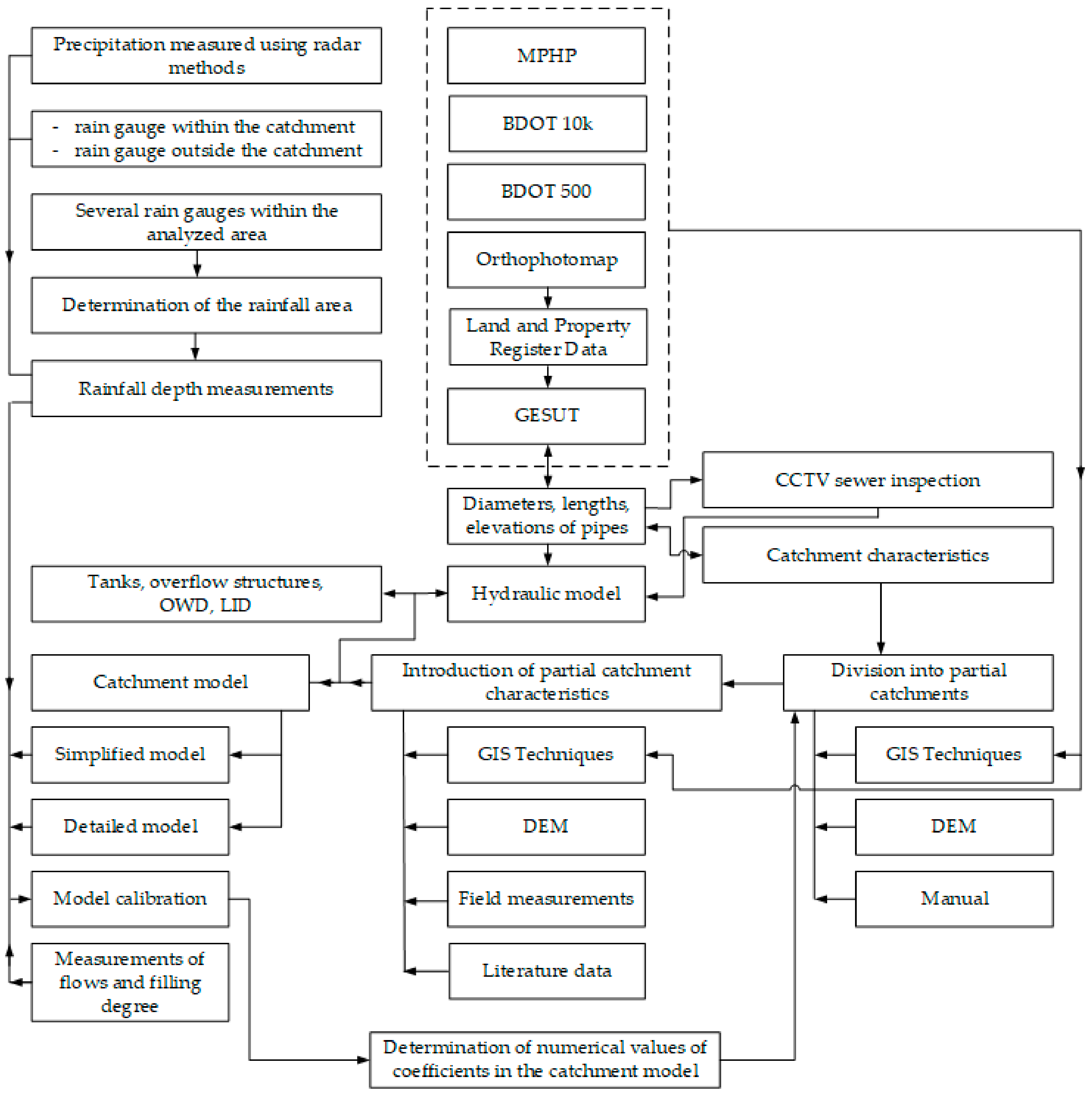
In order to ensure that the obtained rainfall-runoff models are reliable, it is necessary to conduct their calibration and validation. In the course of model calibration, it is important to conduct a sensitivity analysis, which enables identification of the model parameters with a significant influence on the modelled stormwater quantity [78]. Local and global sensitivity analysis methods are employed for this purpose. The local methods are easy to implement; however, their application can be limited and the obtained results may not reflect the actual conditions, because they omit the interaction between the calibrated parameters [79]. The global sensitivity analysis is free of this drawback; however, due to the introduced simplifications, the obtained results do not always reflect the physics of the analysed phenomena. At present, variance-based methods of global sensitivity analysis, which account for the interaction between the calibrated model parameters and their influence on the simulation results, are becoming increasingly popular [80]. Nevertheless, during the sensitivity analysis, the influence of rainfall event space and time distribution is in both cases accounted for to a limited extent, which may affect the selection of optimal values of the catchment model parameters [81,82,83]. Due to the strong interactions between the calibrated parameters, there are issues with their identification. Evaluation of their impact on the calculation results necessitates conducting the so-called uncertainty analysis [32,84,85,86,87]. One of the commonly employed methods employed for this purpose includes GLUE (Generalized Likelihood Uncertainty Estimation) [32,78,88,89]. This approach assumes good matching of the measurement data to the results and governs multiple combinations of the numerical values of the parameters being calibrated. Therefore, the results of calculations in this approach constitute a multivariate distribution of parameters. Nevertheless, the results of the analyses are produced in the form of a cumulative distribution function (CDF), rather than a single set of calibration parameter values. Therefore, the result obtained during a simulation related to, e.g., tank calculation or overflow structure constitutes a likelihood of exceeding the simulated value [90]. In this case, there is a problem in choosing the correct value for designing a sewerage network (structure dimensioning). In order to avoid the above-mentioned issue, the identification of urban catchment models was performed with such optimization methods as evolution algorithms, ant colony optimization algorithms, cuckoo search algorithm, etc. [91,92,93,94]. These solutions enable determination of such a combination of parameters, for which minimum goal function, i.e., best fit of calculation results to measurement values, is obtained. Statistical models, in which the theoretical models are formed on the basis of the accumulated data, constitute an alternative to urban catchment deterministic models. Machine learning, linear and non-linear regression methods, etc., are used for this purpose. In the case where the collected data simultaneously encompass several urban catchments, a universal model can be created on their basis, which constitutes an advantage over the hydrodynamic models. However, they are usually created for predicting a single dependent variable [95,96,97].
On the basis of a literature review [60,87,98] it seems that the use of hydrodynamic models is highly related to the problems with model calibration, the amount of measured data and the required study period. It is important to specify, based on an appropriate literature study on the physics of the investigated phenomenon, whether the assessment of its occurrence can be identified using other available methods and lower financial outlays. Taking this into account, statistical models can be employed for the creation of mathematical models of stormwater and combined networks and the objects located therein. The literature indicates that data mining methods (multiple regression, neural networks, autoregression models, regression trees, fuzzy logic) can be used for modelling the variability of quantity and quality of stormwater in networks [54,99,100]. The logistic regression model, constituting a classification model enabling identification of the overload states in a system (stormwater flooding) is increasingly frequently used for modelling sewerage network objects such as combined sewer overflow structures [60,101]. Due to the complex character of rainfall events and thus the generated operational state of conduits, it is possible to develop a simplified methodology of conducting measurements for the set-up of statistical models. In this case, the application of readily-available data is significant. The identification of rainfall events with a diversified time-course can be supplemented with the data from meteorological radar, eventually by the short term forecasts provided usually by national meteorological services. On the basis of these data, it is possible to prepare for the conducting of field studies, e.g., on the stormwater flooding events within the considered catchment, well in advance. However, such application is limited to small test catchments in which the observation of the stormwater system operation during the rainfall events identified by means of forecasts can be conducted with the data from the afore-mentioned websites. Simultaneously, these data can be employed for controlling the operation of the stormwater overflow structures. In this case, it is possible to apply washable water gauges painted inside conduits and flow chambers, where—on the basis of the observed stormwater table—it can be determined whether the stormwater overflow occurred through the overflow structure. This aspect could be employed as an alternative for collecting the data for the calibration of hydrodynamic models, both local and spatial. In this case, conducting numerous experiments within the investigated sewerage network, during which a network of measurement posts with washable gauges would be created for the identified rainfall events (using the data provided by national meteorological services), should be considered. The acquired data would provide valuable information on the stormwater level within a sewerage network and the operational conditions of stormwater sewers. Therefore, the collection of data on the stormwater water in a sewerage network for numerous rainfall events and subsequently its use for the calibration of a hydrodynamic model seems purposeful. Thus far, this aspect has not been analysed and might constitute an interesting low-cost alternative for the collection of data required for the calibration of the hydrodynamic catchment model. The precipitation data, obtained in advance, can also be applied in monitoring and controlling the leaching of pollutants from sediments of the stormwater system. In this case, it is important to capture the beginning of the leaching connected with the first flush phenomenon, which is essential for the mathematical model calibration [102,103]. The examples presented above constitute an alternative to conducting continuous, long-term monitoring of flows in stormwater networks. They indicate the method for the collection of mathematical models of catchments, simultaneously reducing the costs incurred while conducting long-term measurements [104,105].
A future research subject in this area can be the question of convergence and reliability of automatic calibration systems, i.e., whether these systems can identify the best, but also a real, set of parameters, and eventually how these systems react to unexpected (not identified) errors in the model setup, e.g., missing conduits, structures, sediments, partial blockage of the hydraulic cross-sections, etc.

3. System Data

Setup and calibration/verification of a hydrodynamic model of an urban catchment is a complex task with many uncertainties affecting calculation results [32,78,106,107]. One of the most important uncertainties is connected with the availability, relevancy and accuracy of system data. Therefore, in order to ensure that the obtained simulations are as close to the actual conditions for the observed phenomena as possible, it is essential to collect the data reflecting the actual state. This requires appropriate knowledge encompassing the system structure’s spatial development information and data (possible sources of their acquisition and their accuracy), precipitation data (location of the rain gauges, sensitivity of the employed device), data on the water depths, velocities and volumetric flow rates within a network (conduits, combined sewer overflow structures, retention tanks, etc.), assumptions adopted while building the model connected with its accuracy, as well as discretization of sub-catchments in the model [108,109]. Taking into account the interactions between the above-mentioned data, developing a methodology for catchment model setup seems purposeful. In practice, this is an exceedingly difficult task since in some countries the relevant data considering vector maps, GIS data bases, etc., is available online, whereas in others the access to such data is limited. This is a known issue and the general principles for model setup have been developed. However, they lack details on the possibility of (spatial) data acquisition, determining runoff coefficients in sub-catchments or model calibration methods [110,111,112,113,114,115], which might be significant in the course of selecting the measurement devices, their location or the measurement period. Taking these factors into consideration, a new procedure for building hydrodynamic rainfall-runoff models was proposed, allowing good model quality and overcoming the problems caused by the missing data gaps (Figure 1).

3.1. Spatial Data

The basis for the creation of a hydrodynamic rainfall-runoff model mainly involves spatial data. On their basis, the share of impervious surfaces, size of sub-catchments, and terrain elevations are determined, and the values of roughness coefficients and depression storage are estimated [116,117,118]. Nevertheless, it is vital to determine the reliability of these data. The data used for specifying the catchment characteristics can be obtained from orthophoto maps; additionally, the data from e.g., Inventory of Land and Property Register (LaPR) (PL), State Administration of Land Surveying and Cadastre (ČÚZK) (CZE), can be used to improve their accuracy. This enables an increase in the reliability of data pertaining to impervious surfaces (roofs, parking lots, roads, etc.). However, the accuracy of the input data for model setup based on the general map should be treated as reference. The data required to build a rainfall-runoff model also involve information on diameters, lengths, and pipe slopes. These data can be acquired using the Geodetic Inventory of Network Utilities (GIoNU) database; if unavailable, they can be obtained using the general map. The data related to spatial land management, land topography, as well as the course of the sewerage network are increasingly available for a broad range of users in the form of GIS (Geographic Information System), DTM (Digital Terrain Model) and the data of the sewerage network operator. Digital Terrain Model (DTM), and the data defining the placement of sewer pipes and the course of linear drainage can also be used for this purpose, which ensures relatively small simulation error. The access to DTM is frequently limited, which leads to potential errors and affects the reliability of the coefficients being determined. In such cases, the general map and sewer location can be used, which may however generate errors while determining the catchment characteristics. Model calibration requires rainfall data, especially data with high temporal and spatial-resolution [106,119,120,121].
In our opinion, a further improvement of the urban drainage models is the enhanced integration with local topographic data sources, such as cadastral data, basic (state guaranteed) databases for the GIS, available DTM, orthophoto (aerial) maps, and eventually evaluation of these data sources with respect to local conditions. Despite some activities in this area, we still consider, as an interesting research subject, the use of the different AI based systems for automatic recognition of the sub-catchment/surface types and determination of their hydrologic and hydraulic characteristics. Such a system can make easier the data entry and setup of new models, but also update the data of existing models easily and quickly.

3.2. Sewer System Characteristics

The data presented above are not sufficient to build a flow model of a sewer network, because the values of the conduit roughness coefficients, coefficients of minor energy losses at the inlet and outlet of particular conduits, and share of a hydraulically active cross-section of a conduit, are also required. In order to acquire these data, it is recommended to conduct CCTV inspection of conduits using specialized stationary or mobile cameras [122,123,124]. The results of these studies have a significant effect on the correct selection of coefficient values in rainfall-runoff models for sewer network flow simulation, determining their hydraulic conditions [125]. If no data from CCTV inspection is available, the values of roughness coefficients are determined based on the information pertaining to the type of material the system is made of or by referencing to the literature data [126]. The exemplary values of Manning’s roughness coefficient for the most popular materials of sewerage pipelines are presented in Table 2. At the preliminary calculation stage, or when no data on the sewerage network are available, this might be omitted during the setup of a rainfall-runoff model. This approach has a significant impact on the reliability of the coefficient values determined while modelling the velocity and volumetric flow rate inside the sewerage pipelines.

3.3. Rainfall Data

In many cases, the access to rainfall data is limited or insufficient. This is due to the fact that the number of rain gauges located in the urban area is limited. In many cases, there is none or only a single rain gauge located on the outskirts of the city. The data acquired in this way may be unreliable for calibrating a hydrological catchment model because of lack of knowledge about rainfall spatial distribution. The proper placement of rain gauges should enable determination of the direction and movement of rainfall cells including its speed (especially in large urban areas). The data obtained in this way are reliable and can be used for catchment model calibration. The appropriate rain gauge placement is vital during model setup and preparation of the testing plot [128,129,130,131]. This approach enables the acquiring of reliable values of calibrated parameters in rainfall-runoff models, which is essential for their application in the analyses of sustainable catchments’ development. Due to the local nature of rainfall, land topography and land development, the optimal placement of rain gauges is a very complex task. The current analyses do not provide unequivocal data and the determined dependences indicating the maximum distance between rain gauges in terms of sewerage network modelling omit the above-mentioned aspects. There is no general, clear unified methodology for the placement of rain gauges in urban catchments, which hinders the planning of research and the performing of experiments, and leads to problems related to model calibration in terms of reliable input data for the hydrodynamic rainfall-runoff model. However, Schilling [128] and Einfalt [132] summarized suitable precipitation information for operation and design of urban drainage systems as follows: at least 20 years of recordings without data gaps, a volumetric accuracy of less than 3%, and a spatio-temporal resolution of 1 km2 and 1 min, respectively [133].
A source of very good and reliable rainfall current data is meteorological radar. Radar devices provide wide-area scanning, with sufficient spatial resolution (pixels from 100 m up to 1 km), and temporal resolution (1–10 min) in a typical range of 30–200 km. Such resolutions are sufficient for most urban rainfall-runoff models. The use of radar also allows the provision of operational rainfall information in real time; this allows the deployment of the real control of sewer systems [133].
Future research trends in this area could be support for the generation of synthetic rainfall series directly in the model environment (possibly with a spatial distribution) based on user-defined IDF curves, or definition of a standard long-term rainfall series (possibly with a spatial distribution) in order to be able to assess the most unfavourable flood situations in the urban river basin (e.g., combination of rainfall intensity, spatial characteristics, direction and movement speed of rainfall copulas).
An interesting research issue is the examination of extreme flood events and situations, e.g., a combination of snowmelt and rainfall, eventually combined with frozen permeable surfaces in winter or springtime. Another research subject is research into the synergy between extreme rainfall and flood situation in urban river networks (both these phenomena may or may not be statistically interdependent).

4. Model Parameters

Model parameters are all the system data that we are not able to quantify based on catchment/sewerage system inspection (e.g., depression storage, time of concentration, catchment/sewer roughness, depression storage, infiltration, etc.) [134]. At this stage of the model setup, the tasks to be fulfilled by the model must be specified. The model may be used for estimating the catchment runoff which requires less detailed data [87,103]; alternatively, the model can be used for simulating the sewer overflow or stormwater flooding, which necessitates highly detailed data.

4.1. Surface Roughness and Runoff Coefficients

While creating a hydrodynamic rainfall-runoff model, it is necessary to identify numerous parameters that constitute the input data [11,22], including the catchment characteristics describing the land development, hydrological properties and the sewerage network parameters [54]. Surface imperviousness and coefficient of surface runoff constitute two of the numerous parameters identified in the catchment models on the basis of the spatial databases [135,136]. The values of surface imperviousness and their runoff coefficients can be determined on the basis of map-based records, as well as satellite maps. By using the remote sensing data, the catchment imperviousness can be determined [116,137]. Selection of an appropriate catchment designation method in the model also affects the size of a sub-catchment. This is an essential issue, because it has influence on the variability of the surface area in the model as well as the values of runoff coefficients being calibrated. The exemplary values of runoff coefficient for various surface types are presented in Table 3, while Table 4 presents collected literature values of roughness coefficient for different land usage types.
By using the available measurement methods, it is possible to identify the values of pipe (channel) roughness coefficients using laboratory methods [152]. By conducting the flow measurements at the inlet and outlet in a single pipe with the specified diameter, slope and length, the roughness values can be determined [153,154]. However, this is difficult to perform under the real conditions in a sewer network. It should be noted that during operation, depending on the catchment type, substantial amounts of suspended solids and resultant sediments of various roughness coefficient may occur and flow in the stream, which in the long-term changes the average roughness of the pipe walls [155]. Moreover, it should be remembered that, depending on the local conditions, biofilm may cover the pipe walls, and the deposits and sediments on the pipe bottom can reduce its cross section and change the flow conditions, which affects the values of parameters identified in the hydrodynamic model [156,157,158]. This is extremely difficult to determine, because CCTV inspection of sewer pipes should be performed after each rainfall event, which would provide reliable data about the pipe’s physical and hydraulic characteristics. At present, this aspect and its variability in time is omitted due to the technical difficulties connected with conducting measurements, as well as the high cost and time required for performing CCTV inspection. In numerous cases, the minor energy loss coefficients in the inspection chambers as well as the inlet and outlet of the pipe are omitted and the pipe roughness is increased by a certain value [159].

4.2. Subcatchment Area

In practice, the assumption that the uncertainty of coefficient values identification in the surface runoff model increases with the area of the sub-catchment model seems to be correct [80,89]. In turn, the lower the catchment resolution, the greater the variability of the coefficients being calibrated can be. The accuracy of spatial data is important for ensuring that the determined catchment characteristics in a more detailed model are more reliable than in a model with a limited number of sub-catchments. At this stage, in order to reduce the error related to the assessment of coefficient values in a model, the application of DTM is essential, provided that the catchment size is appropriately selected—the terrain slope is relatively uniform and the land development is homogeneous. Meeting the above-mentioned assumptions pertaining to the division of sub-catchments in a model is a key stage of its creation. However, due to diversified data resources (stormwater systems, spatial data on land development, longitudinal slope of the catchment, etc.), the simplifications adopted while determining the catchment resolution in the model significantly affect the reliability of the coefficients describing the sub-catchments, which in turn influences the catchment calibration process. The surface imperviousness in urban catchments can be indicated by using the collected data and machine learning methods [101,160]. On the basis of this approach and identification of reference areas, other parameters requiring calibration in hydrodynamic urban rainfall-runoff models, beside runoff coefficients, can also be determined, i.e., depression storage and roughness coefficients [161,162]. In this approach, the appropriate selection of the learning sample (application of machine learning methods) which enable identification of the hydrodynamic model parameters, is essential. The employed approach is extremely important for reducing the model uncertainty, which affects the values of other calibrated parameters that are non-measurable [51,67,87]. Of course, the values of calibrated parameters in the entire model can be assumed as fixed values describing the impervious and pervious surfaces. This approach is employed during the catchment model calibration [89,157]; however, it constitutes a source of uncertainty, because the retention of impervious surfaces, roofs, roads, or parking lots differ. Assumption of identical values and their allocation for all impervious surfaces is a source of uncertainty, which is confirmed by the simulation results [89].
Another important parameter during model setup, affecting the accuracy of the obtained results, is the adopted method of runoff width determination [147,163,164]. According to Rossman [55], the catchment width depends on the total surface and mean runoff length. In order to estimate the width, the geometrical shape of each sub-catchment is simplified to a rectangle, but also a divergent and convergent shape with the corresponding surface area [165]. In the case of partial catchments which are symmetrical in terms of pipe placement, the catchment width can be determined solely on the basis of pipe length. In the case of catchments which are non-symmetrical in relation to the pipe, the catchment skewness coefficient also has to be taken into account. Some authors suggest accounting only for the impervious surface area of the partial catchments, rather than the total partial catchment surface area [166].

4.3. Infiltration Ratio

Infiltration is an important parameter identified during model calibration, which can be determined on the basis of field studies. At the initial stage, adoption of an appropriate mathematical model (Horton’s, Green and Ampt, etc.) is important because it affects the course of the measurement experiment and the employed measurement devices. Nevertheless, due to the urban conditions, the fact that catchments span over large areas may hinder determination of the parameters in the infiltration model [167,168]. In the urban area, several questions arise: to what extent will the obtained measurement results for the representative areas differ from each other, what will be the impact of this difference on the results, will infiltration be a key factor requiring calibration in the investigated model, and can the values from literature be assumed? During model calibration, the catchment is usually divided into areas with similar soil characteristics, which is simultaneously a source of uncertainty that should be thoroughly analysed. While gathering the data for the creation of a hydrodynamic catchment model, the field measurements are important for its further calibration, reducing the uncertainty of the coefficients being determined. These measurements may lead to determination of the values of calibrated parameters—coefficients in the Horton model (see Table 5 for the exemplary input data for Horton model), which may significantly affect the correlation between the calculation results and measurements, and reduce the interactions between the coefficients included in the model [168]. However, this may not be an essential aspect at the stage of determining the input data for the model, because in many cases, in relation to the modelled rainfall event (intensive or long-term rainfalls with high rainfall depth) and the portion of the pervious areas (generally impervious city centers vs. green and pervious city outskirts), it turned out that the infiltration process dynamics have negligible influence on the results obtained while calculating the variability of catchment runoff.

4.4. Personal Catchment Survey

We consider it extremely important to become familiar with the hydrological conditions of the particular catchments, ideally by a personal walk in the river basin. In many cases, water from the surface drain is unable to reach the sewers for various reasons—e.g., obstacles such as small garden walls, depressions, fences with masonry, etc. It is also advisable to find out directly in situ whether the drainage of surfaces (e.g., roof gutters) is connected to the sewer network.
We also found it very useful to perform a personal survey (inspection) of the sewer network, allowing assessment of the flow rates of infiltrated water, e.g., during the night, when the sanitary flow is minimal. Another benefit of such survey can be related to checking of the structure (topology) of the network, connection of pipes, detection of large (as well as illegal) inflows, hydraulic arrangement of sewer structures, etc. In many cases such inspection can reveal various construction modifications that are not officially recorded in the sewer network documentation (e.g., sewer pipe interconnections, increase or decrease of the weir crest level in the combined sewer overflow).

5. Calibration Data

During the planning of a measurement experiment aiming at the calibration of the hydrodynamic model, determining the purpose is of key importance. From the data collection viewpoint, it is important whether the model is to be applied for research problems or practical issues including catchment management, expansion, modernization and/or application of LID systems, predicting the stormwater and combined overflows amount discharged into the river, or perhaps as a basis for designing a stormwater treatment plant. These are highly relevant factors, which should be accounted for, because they affect the dimensions of used devices, their number and type. It should be noted that, apart from the sewage quantity, its quality can also be measured, which is much more time-consuming and labour-intensive in the case of the collection of the sewage quality samples [171]. In numerous instances, the research problem and catchment size are selected so that the latter spans a homogeneous area, e.g., with identical development [32,60,69]. This is important in terms of relatively low spatial differentiation of the values of calibrated model parameters or one calibration point available.
Precipitation measurements are essential for the model calibration. An important factor is the catchment area, which governs the number of rain gauges to be applied [106]. The temporal as well as spatial resolution of precipitation data, location of the rain gauge and the employed measurement device are of great importance. In this case, the factors which may significantly hinder the determination of reliable coefficient values in the model include the catchment size and the number of rain gauges placed within it. In large urban catchments, one of the crucial parameters is the rainfall spatial distribution. Therefore, this should be included during the model calibration, because it may significantly affect the reliability of the determined calibration parameter values and the reduction of their uncertainty. This is a highly important issue during the calibration of large sewerage network models [172,173,174,175]. A certain optimum should be achieved, where the number of rain gauges in a catchment should ensure high correlation between the results of simulations and measurements. Simultaneously, the number of rain gauges should not be too high to avoid excessive cost generation. Therefore, it should be optimized in relation to the local conditions. Time resolution of measurement data, combined with wetting, wind conditions, rain gauge resolution and calibration, are other important factors. In many cases the higher the resolution of data, the lesser the uncertainty of measurement. However, time resolution is only one factor affecting the measurement uncertainty (others are wetting, wind conditions, proper calibration of rain gauges, resolution of rain gauges, proper location of rain gauges, etc.). Generally, shorter time steps decrease uncertainty of measurement, but such a statement is valid only for a specific type of rain gauges placed in specific spot. Reducing the measurement frequency of rainfall events in the range of 1–5 min [176], on the example of a small urban catchment in Częstochowa, indicated a negligible influence on the results of simulations performed with a hydrodynamic rainfall-runoff model. However, this fact cannot be generalized, because the catchment and sewerage network characteristics are significant factors that should not be ignored in analyses [106].
Regarding flow measurement, the location of measurement devices in the sewerage network is another problematic issue. This is especially important due to the cost of purchasing the device and the specificity of conducting continuous measurements. Analyses are being currently conducted in this respect; however, they are of a local and fragmentary nature [32,60,69]. In case the measurement devices are unavailable, hydrologic methods can be employed [177]. One of the simplest devices includes water gauges, which can be easily used in a sewerage network by painting a washable gauge on the walls of the conduits, diversion chamber, wells, and impounding reservoirs. However, this only enables determination the maximum stormwater level in a given event. Although a single measurement, corresponding—for instance—to the maximum conduit filling level constitutes a relatively small amount of data, when performed along the locations in the entire network it may be a valuable source of data which can be used during the model calibration. The calibration parameter values obtained in this manner will undoubtedly be characterized by much higher uncertainty than in the case when the model is calibrated on the basis of continuous flow or pipe filling measurements. A flow measurement method is significantly affected by the type of calibration, i.e., continuous, based on time-series or isolated rainfall events. Calibration of a model using continuous time-series is a solution ensuring less uncertainty about the identified calibration parameters. Due to technical issues, the problems with continuous data acquisition may occur in the course of measurements, which stems from the specificity of the sewerage network operation. This problem is important, because when a single measurement device is used in a cross-section closing the catchment, the conditions in the pipes above are affected by uncertainty [178]. The use of additional measurement devices, depending on the requirements set for the model, enables a reduction in the uncertainty of measurement data, and thus ensures a more accurate calibration of the catchment model parameters [179]. In terms of calibrating the model parameters of large catchments, the situation is more difficult [180], due to a substantial number of pipe segments and partial catchments. This hinders the placement of flow meters in the locations that maximize the reliability of simulation results, while simultaneously keeping their number—and related costs—at a minimum. This task is made even more difficult due to the spatial differentiation of land use and the course of pipes. While the location of pipes and its variability in the plan are described by means of the network topology methods, it is difficult to analytically describe the spatial differentiation of land and its use. The analyses performed for small urban catchments and thus small sewerage networks indicate that the location of measurement devices can be optimized using fractal geometry methods [181,182]. However, a question as to whether Stachler’s laws—used for rivers—should be implemented in the description of the sewerage network arises in the case of these objects [183]. There are a number of technical issues connected with the implementation of this idea, as well as lack of a devised calculation methodology; nevertheless, in the case of small catchments, this solution may constitute an alternative to fractal geometry.

6. Data for Optimization

The basic precondition for using the model to optimize the runoff process in an urban catchment is its previous calibration and successful verification. If the simulation results related to sustainable development are to be considered reliable, there is a need to collect and inventory the works determining the areas within the catchment which are to be rebuilt. The information on the applied materials and adopted solutions is essential, because it enables determination of the catchment characteristics for the hydrodynamic rainfall-runoff model. Placement of the new investment in the area of existing stormwater system is another important factor, because it generates the need to modify the employed hydrodynamic rainfall-runoff model of the catchment (if such a model already exists) [184,185]. While modelling a catchment, information on the planned objects regarding reduction in surface runoff (green roofs, infiltration devices, rain gardens, etc.) is essential; in this case it is important to select such simulation parameters, e.g., reduction in runoff coefficient values, that will enable the achieving of similar values under the operational conditions [186,187].
The rainfall data is vital for conducting the simulations related to hydraulic sewerage networks as well as the analyses of their operation. In line with the DWA A-118E [188] guidelines, the assessment of sewerage network capacity by means of hydrodynamic modelling requires continuous multiannual rainfall data, spanning at least 30 years. If unavailable, the simulation of flow in sewerage systems has to be performed using IDF (intensity-duration-frequency) curves describing the relationship between the maximum rainfall intensity and its duration as well as rainfall frequency. The DDF (depth—duration—frequency) curves are used in the design practice and scientific studies. In numerous cases, the capacity of the sewerage network, as well as the objects located therein are designed and analysed using the rainfall model in which constant rainfall intensity is assumed in line with the IDF or DDF model or artificial rainfall such as Chicago or Sifalda storms. However, the application of the Euler type II rainfall distribution model, in which 70% of rainfall depth occurs in 20% of rainfall event duration, is recommended for conducting the sewerage network capacity analysis [188]. The exemplary artificial rainfall models are presented in Figure 2.
When the rainfall time series are shorter than 30 years, rainfall prediction models are used. Three basic methods can be enumerated in this case. The first is based on fractal geometry, in which a rainfall generator is created by using canonical micro-cascades [189,190,191]. This solution is useful even in the case of a relatively short rainfall time series [191]. In the second method, statistical methods, such as multidimensional scaling, are employed for rainfall generation [27]. Currently, this method is enjoying great popularity, because it enables accounting for the climate change in rainfall characteristics as well as prediction of the rainfall while taking this change into consideration. This is essential from the point of view of designing sewerage networks and objects located within (combined sewer overflow structures, tanks, etc.). The last method employed for rainfall simulation is based on connecting functions, so-called copula, which link the marginal distributions of rainfall characteristics (rainfall depth, duration, time distribution of rainfall in a rainfall event) [192]. In this approach, the rainfall characteristics from the measurement period are determined on the basis of the isolated rainfall events [187,193]. This enables determination of their empirical distributions and matching of the theoretical distributions [194]. In the next step, the appropriate functions connecting marginal distributions are selected, which enables the obtaining of multidimensional distribution used in calculations. The rainfall simulation on the basis of the determined theoretical distributions can also be performed using modified Monte Carlo methods, e.g., the Iman-Conover method, which accounts for the fact that the modelled variables are correlated with each other. Rainfall generators are commonly used in scientific studies [60,98,186]. Obtained data are employed for simulating the operation of sewerage networks including the volume of stormwater flooding [193,195], capacity of retention tanks [89,196], and as the volume and number of discharges through combined sewer overflow structures [98,196,197,198].

7. Rainfall-Runoff Models and the Decision-Making Process

A very useful and practical tool for planners can be the interconnection of the hydraulic models (and their results) with the GIS support for decisive systems, focused on the optimal sewer system rehabilitation strategy and (technical and financial) extent, considering the hydraulic, construction and ecologic status of the sewer network.
Several studies have confirmed that LIDs (Sustainable Drainage Systems, SUDs) have a positive impact on the hydrological and hydraulic load of traditional urban drainage systems; however, the biggest reduction was achieved in cases of small, relatively frequent rainfall events and more pervious soil types [199,200,201,202,203,204]. In case of extreme rainfall events, such a reduction in flow (water volume) is very limited and sensitive to local conditions. Therefore, it is wise to appropriately integrate SUDS and traditional drainage solutions to enhance their synergy for drainage design [205].
According to the experience of the authors [5], some of the SUD and LID measures can be implemented in urban areas relatively easily, without substantial technical problems and with reasonable investment costs [206,207,208]. Beyond a certain level, the implementation of these measures starts to raise technical problems, which induce relatively high investment costs, whereas the contribution to runoff reduction is small. Finding this limit using a model approach and optimization could be very beneficial for urban planners.
The study of [209] provides evidence that the fate of infiltrated stormwater largely depends on surrounding land use and that infiltrated stormwater may not always reach receiving streams as baseflow, as often assumed. As the study shows, in summer, most of the infiltrated stormwater was evapo-transpired by the vegetation downslope of the basin, and thus did not reach the receiving stream. The reverse was true in the colder months, where some infiltrated stormwater did reach the stream as plant water use declined. Particularly during these summer-autumn months, anthropogenic disturbances interacted with the plume of infiltrated stormwater: infiltrated stormwater seeped into nearby sewer infrastructure. All of this has implications for the design and placement of infiltration structures. In our opinion, there is a need to refine conceptual models of urban catchment and stormwater models.
Another question is that of sewer system sealing. The experience of many sewage system operators shows that sealing a specific part of a sewer system (typically a part of the sewer system with high groundwater infiltration) will cause groundwater level increase and extensive groundwater infiltration into pipes starting on different parts of the sewer system, and eventually in household connections [210,211]. Such repeated processes can lead to significant groundwater level increase, which can endanger the infrastructure (buildings, cellars) in the urban catchment. A predictive model support for such repair and sealing activities can be very helpful for the planning and implementation of such rehabilitation measures.

8. Summary and Conclusions

Drainage models from sewer networks have fundamentally changed the concept of the design and assessment of sewer networks. In the older concept, statistically processed rainfall data were used. Based on these, the maximum flow was calculated and a sewer network was designed. It was assumed that the periodicity of the incurred effect on the sewer network (hydraulic surcharge, flooding, CSO events) is approximately the same as the periodicity of the design rain, or at least that these two quantities are directly dependent. However, as research work has shown [211], the actual periodicity of the effect and the periodicity of the design’s rain are not in a statistically significant correlation. The reason for this fact is that the effect on the sewer network is rather dependent on random constellations of temporally and spatially variable precipitation (e.g., several consecutive rains) and concentration and runoff time. Therefore, the opposite approach is used today. The first step is to perform a long-term simulation of runoff, based on historic rainfall data and subsequently (second step) statistical processing of the effect occurrence, e.g., determination of the periodicity of hydraulic surcharge, flooding, CSO events based on the simulation results.
Summing up the above-presented literature review, it can be stated that the creation of a rainfall-runoff model is a complex task requiring the collection of spatial data involving the characteristics of the catchment, sewerage network and the conditions within. Collection of highly reliable data is not an easy task and determination of which type of data discussed above has the greatest influence on the simulation results is very difficult. This results from numerous interactions between the variables in the model, which is confirmed in the model setup scheme (Figure 1). It is obvious that—for instance—by employing more accurate precipitation field measurements in a catchment, but less detailed information on the conduit and conditions within them, a strongly non-linear interaction occurs between the considered variables, and determination of its impact on the reliability of the coefficients being identified in the model is very complex. There are many more such interactions, and their analysis is a highly complicated task requiring the implementation of complex statistical models. This constitutes the topic of numerous works [187,212,213]; however, in order to provide a clear indication as to how to create a model, which types of data contribute to a relatively small error in the identification of coefficients in a model, and which cause much greater error, is very difficult to assess. This happens because—in fact—there is a multitude of sources and data acquisition methods; additionally, not all data are typically quantitative. There are also qualitative data which require uniformization and clear differentiation through appropriate quality classes in terms of acquisition of reliable coefficient values in the model being calibrated.
An important way to minimise the inaccuracies and uncertainties of the model parameters is proper calibration and successful verification of the model. However, the basic premise for this is correct definition of model input data, i.e., physical data about the sewerage network including data concerning sub-catchment characteristics and rainfall data. The possibilities of using weather radar to obtain rainfall data have been described above; we assume that nowadays there should be no bigger problem with obtaining this data. From the point of view of the physical data reliability (based on personal experience), the biggest problems are caused by data on the ‘point’ elements (structures), such as division chambers, combined sewers overflows, storage tanks, pumping stations, etc. Therefore, for projects that involve rainfall-runoff modelling, we recommend personal inspection of such structures. Personal inspection may reveal possible discrepancies between the actual status of the structures compared with the available documentation, as well as additional construction modifications of these structures, not recorded in the documentation. Missing data can be then added/updated using simple measurement methods.
In our opinion, future research considering rainfall-runoff models should fill in the described gaps in knowledge and focus on: (i) determination of convergence and reliability of the automatic calibration systems; (ii) improvement of enhanced models’ integration with local topographic data sources; (iii) evaluation of 1D and 3D detailed modelling to answer the question considering precision of the currently used (1D) approach of the hydraulic modelling of sewer system structures; (iv) support for the generation of synthetic rainfall series directly in the model environment based on user-defined curves; (v) modelling interactions between LID devices, including infiltration, groundwater and traditional drainage systems, to achieve the optimal synergy for urban drainage and economic sustainability; (vi) optimization of the urban drainage systems based on modelling of water quality and consequent minimization of the pollution transport into receiving surface waters.

Author Contributions

Conceptualization, B.S., G.Ł. and D.S.; methodology and visualization, B.S.; formal analysis B.S., G.Ł., D.S. and M.S.; writing—original draft preparation, B.S., G.Ł., A.M.-P. and M.K.W.; writing—review and editing, B.S., G.Ł., A.M.-P., M.K.W., D.S., M.S., J.P. and R.B. All authors have read and agreed to the published version of the manuscript.

Funding

Work and APC was financially supported by subvention of particular scientific units. For elaboration of paper also contributed the support under the Operational Program Research and Innovation for the project: Research on the impact of biotic and abiotic factors on soil-water-atmosphere-plant cover components, 313011T620, co-financed by the European Regional Development Fund, 13-GASPU-2021 “Blue-green infrastructure as a basis for climate adaptation of land management in agricultural and urbanized land”.

Institutional Review Board Statement

Not applicable.

Informed Consent Statement

Not applicable.

Data Availability Statement

Not applicable.

Conflicts of Interest

The authors declare no conflict of interest.

References

  1. Mariolakos, I. Water resources management in the framework of sustainable development. Desalination 2007, 213, 147–151. [Google Scholar] [CrossRef]
  2. Hurlimann, A.; Wilson, E. Sustainable Urban Water Management under a Changing Climate: The Role of Spatial Planning. Water 2018, 10, 546. [Google Scholar] [CrossRef] [Green Version]
  3. Garcia, M.; Koebele, E.; Deslatte, A.; Ernst, K.; Manago, K.F.; Treuer, G. Towards urban water sustainability: Analyzing management transitions in Miami, Las Vegas, and Los Angeles. Glob. Environ. Chang. 2019, 58, 101967. [Google Scholar] [CrossRef]
  4. Özerol, G.; Dolman, N.; Bormann, H.; Bressers, H.; Lulofs, K.; Böge, M. Urban water management and climate change adaptation: A self-assessment study by seven midsize cities in the North Sea Region. Sustain. Cities Soc. 2020, 55, 102066. [Google Scholar] [CrossRef]
  5. Musz-Pomorska, A.; Widomski, M.K.; Gołębiowska, J. Financial Sustainability of Selected Rain Water Harvesting Systems for Single-Family House under Conditions of Eastern Poland. Sustainability 2020, 12, 4853. [Google Scholar] [CrossRef]
  6. Arfanuzzaman, M.; Atiq Rahman, A. Sustainable water demand management in the face of rapid urbanization and ground water depletion for social–ecological resilience building. Glob. Ecol. Conserv. 2017, 10, 9–22. [Google Scholar] [CrossRef]
  7. Yang, T.H.; Liu, W.C. A General Overview of the Risk-Reduction Strategies for Floods and Droughts. Sustainability 2020, 12, 2687. [Google Scholar] [CrossRef] [Green Version]
  8. Yu, H.; Huang, G. A coupled 1D and 2D hydrodynamic model for free-surface flows. Proc. Inst. Civ. Eng. Water Manag. 2014, 167, 523–531. [Google Scholar] [CrossRef]
  9. Santamarta, J.C.; Neris, J.; Rodríguez-Martín, J.; Arraiza, M.P.; López, J.V. Climate Change and Water Planning: New Challenges on Islands Environments. IERI Procedia 2014, 9, 59–63. [Google Scholar] [CrossRef] [Green Version]
  10. De Paola, F.; Giugni, M.; Pugliese, F.; Romano, P. Optimal Design of LIDs in Urban Stormwater Systems Using a Harmony-Search Decision Support System. Water Resour. Manag. 2018, 32, 4933–4951. [Google Scholar] [CrossRef]
  11. Azadi, F.; Ashofteh, P.-S.; Loáiciga, H.A. Reservoir Water-Quality Projections under Climate-Change Conditions. Water Resour. Manag. 2019, 33, 401–421. [Google Scholar] [CrossRef]
  12. Harding, R. Ecologically sustainable development: Origins, implementation and challenges. Desalination 2006, 187, 229–239. [Google Scholar] [CrossRef]
  13. Wang, L.; Ye, M.; Lee, P.Z.; Hicks, R.W. Support of sustainable management of nitrogen contamination due to septic systems using numerical modeling methods. Environ. Syst. Decis. 2013, 33, 237–250. [Google Scholar] [CrossRef]
  14. Cardoso de Salis, H.H.; Monteiro da Costa, A.; Moreira Vianna, J.H.; Azeneth Schuler, M.; Künne, A.; Sanches Fernandes, L.F.; Leal Pacheco, F.A. Hydrologic Modeling for Sustainable Water Resources Management in Urbanized Karst Areas. Int. J. Environ. Res. Public Health 2019, 16, 2542. [Google Scholar] [CrossRef] [Green Version]
  15. Leigh, N.; Lee, H. Sustainable and Resilient Urban Water Systems: The Role of Decentralization and Planning. Sustainability 2019, 11, 918. [Google Scholar] [CrossRef] [Green Version]
  16. Simonovic, S. Systems Approach to Management of Water Resources—Toward Performance Based Water Resources Engineering. Water 2020, 12, 1208. [Google Scholar] [CrossRef]
  17. Jurik, L.; Pokrývková, J. Urban Water retention—Theoretical Aspects and Practical Measures. Zadržiavanie vody v mestách—teória a praktické riešenia. Životné Prostr. 2018, 52, 42–48. [Google Scholar]
  18. Towsif Khan, S.; Chapa, F.; Hack, J. Highly Resolved Rainfall-Runoff Simulation of Retrofitted Green Stormwater Infrastructure at the Micro-Watershed Scale. Land 2020, 9, 339. [Google Scholar] [CrossRef]
  19. Lee, J.G.; Nietch, C.T.; Panguluri, S. Drainage area characterization for evaluating green infrastructure using the Storm Water Management Model. Hydrol. Earth Syst. Sci. 2018, 22, 2615–2635. [Google Scholar] [CrossRef] [Green Version]
  20. Thiagarajan, M.; Newman, G.; Zandt, S. The Projected Impact of a Neighborhood-Scaled Green-Infrastructure Retrofit. Sustainability 2018, 10, 3665. [Google Scholar] [CrossRef] [Green Version]
  21. Zeleňáková, M.; Diaconu, D.C.; Haarstad, K. Urban Water Retention Measures. Procedia Eng. 2017, 190, 419–426. [Google Scholar] [CrossRef]
  22. Lee, J.G.; Heaney, J.P. Estimation of Urban Imperviousness and its Impacts on Storm Water Systems. J. Water Resour. Plan. Manag. 2003, 129, 419–426. [Google Scholar] [CrossRef]
  23. Jayasooriya, V.M.; Ng, A.W.M. Tools for Modeling of Stormwater Management and Economics of Green Infrastructure Practices: A Review. Water Air Soil Pollut. 2014, 225, 2055. [Google Scholar] [CrossRef] [Green Version]
  24. Singh, A.; Sarma, A.K.; Hack, J. Cost-Effective Optimization of Nature-Based Solutions for Reducing Urban Floods Considering Limited Space Availability. Environ. Process. 2020, 7, 297–319. [Google Scholar] [CrossRef]
  25. Endreny, T.A. Land Use and Land Cover Effects on Runoff Processes: Urban and Suburban Development. In Encyclopedia of Hydrological Sciences; John Wiley & Sons, Ltd.: Chichester, UK, 2005. [Google Scholar]
  26. Goncalves, M.L.R.; Zischg, J.; Rau, S.; Sitzmann, M.; Rauch, W.; Kleidorfer, M. Modeling the effects of introducing low impact development in a tropical city: A case study from Joinville, Brazil. Sustainability 2018, 10, 728. [Google Scholar] [CrossRef] [Green Version]
  27. Cristiano, E.; ten Veldhuis, M.-C.; van de Giesen, N. Spatial and temporal variability of rainfall and their effects on hydrological response in urban areas—A review. Hydrol. Earth Syst. Sci. 2017, 21, 3859–3878. [Google Scholar] [CrossRef] [Green Version]
  28. Schmitt, T.G.; Ressourcen, T.U.K.I.W.I. Regenwasser in Urbanen Räumen—Aqua Urbanica Trifft RegenwasserTage 2018: Landau in der Pfalz, 18./19. Juni 2018; Tagungsband; Schriftenreihe Wasser Infrastruktur Ressourcen; Technische Universität Kaiserslautern, Institut Wasser Infrastruktur Ressourcen: Germany, Kaiserslauter, 2018; ISBN 9783959740869. [Google Scholar]
  29. Li, C.; Wang, W.; Xiong, J.; Chen, P. Sensitivity Analysis for Urban Drainage Modeling Using Mutual Information. Entropy 2014, 16, 5738–5752. [Google Scholar] [CrossRef]
  30. Leandro, J.; Martins, R. A methodology for linking 2D overland flow models with the sewer network model SWMM 5.1 based on dynamic link libraries. Water Sci. Technol. 2016, 73, 3017–3026. [Google Scholar] [CrossRef]
  31. Kwak, D.; Kim, H.; Han, M. Runoff Control Potential for Design Types of Low Impact Development in Small Developing Area Using XPSWMM. Procedia Eng. 2016, 154, 1324–1332. [Google Scholar] [CrossRef] [Green Version]
  32. Fraga, I.; Cea, L.; Puertas, J.; Suárez, J.; Jiménez, V.; Jácome, A. Global Sensitivity and GLUE-Based Uncertainty Analysis of a 2D-1D Dual Urban Drainage Model. J. Hydrol. Eng. 2016, 21, 04016004. [Google Scholar] [CrossRef]
  33. Hodges, B.R. Conservative finite-volume forms of the Saint-Venant equations for hydrology and urban drainage. Hydrol. Earth Syst. Sci. 2019, 23, 1281–1304. [Google Scholar] [CrossRef] [Green Version]
  34. Yu, C.W.; Hodges, B.R.; Liu, F. A new form of the Saint–Venant equations for variable topography. Hydrol. Earth Syst. Sci. 2020, 24, 4001–4024. [Google Scholar] [CrossRef]
  35. Yu, C.W.; Liu, F.; Hodges, B.R. Consistent initial conditions for the Saint-Venant equations in river network modeling. Hydrol. Earth Syst. Sci. 2017, 21, 4959–4972. [Google Scholar] [CrossRef] [Green Version]
  36. Dong, B.; Xia, J.; Zhou, M.; Li, Q.; Ahmadian, R.; Falconer, R.A. Integrated modeling of 2D urban surface and 1D sewer hydrodynamic processes and flood risk assessment of people and vehicles. Sci. Total Environ. 2022, 827, 154098. [Google Scholar] [CrossRef]
  37. Sañudo, E.; Cea, L.; Puertas, J. Modelling Pluvial Flooding in Urban Areas Coupling the Models Iber and SWMM. Water 2020, 12, 2647. [Google Scholar] [CrossRef]
  38. Yang, Q.; Ma, Z.; Zhang, S. Urban Pluvial Flood Modeling by Coupling Raster-Based Two-Dimensional Hydrodynamic Model and SWMM. Water 2022, 14, 1760. [Google Scholar] [CrossRef]
  39. Chen, Z.; Han, S.; Zhou, F.Y.; Wang, K. A CFD Modeling Approach for Municipal Sewer System Design Optimization to Minimize Emissions into Receiving Water Body. Water Resour. Manag. 2013, 27, 2053–2069. [Google Scholar] [CrossRef]
  40. Dufresne, M.; Vazquez, J.; Terfous, A.; Ghenaim, A.; Poulet, J.-B. CFD Modeling of Solid Separation in Three Combined Sewer Overflow Chambers. J. Environ. Eng. 2009, 135, 776–787. [Google Scholar] [CrossRef]
  41. Stovin, V.R.; Saul, A.J. Computational Fluid Dynamics and the Design of Sewage Storage Chambers. Water Environ. J. 2000, 14, 103–110. [Google Scholar] [CrossRef]
  42. Scottish Water—Report a Problem. 2020. Controlled Sewerage Discharge into Scottish Rivers and Watercourses. Available online: https://www.lochlomondangling.com/news/2020/07/07/controlled-sewerage-discharge-into-scottish-rivers-and-watercourses/ (accessed on 24 December 2020).
  43. Martin, B. A Combined Sewer Overflow Control Alternative for Long Term Control Plans; New Jersey Department of Environmental Protection, Division of Water Quality Evaluating Green Infrastructure: Trenton, NJ, USA, 2018.
  44. Chanson, H.; Gualtieri, C. Similitude and scale effects of air entrainment in hydraulic jumps. J. Hydraul. Res. 2008, 46, 35–44. [Google Scholar] [CrossRef] [Green Version]
  45. Beceiro, P.; Almeida, M.C.; Matos, J. Numerical modelling of air-water flows in sewer drops. Water Sci. Technol. 2017, 76, 642–652. [Google Scholar] [CrossRef] [PubMed]
  46. Sepehri, M.; Malekinezhad, H.; Ilderomi, A.R.; Talebi, A.; Hosseini, S.Z. Studying the effect of rain water harvesting from roof surfaces on runoff and household consumption reduction. Sustain. Cities Soc. 2018, 43, 317–324. [Google Scholar] [CrossRef]
  47. Rossman, L.A. Modeling Low Impact Development Alternatives with SWMM. J. Water Manag. Model. 2010, 18, 167–182. [Google Scholar] [CrossRef] [Green Version]
  48. Aronica, G.; Cannarozzo, M. Studying the hydrological response of urban catchments using a semi-distributed linear non-linear model. J. Hydrol. 2000, 238, 35–43. [Google Scholar] [CrossRef]
  49. Guo, J.C.Y.; Cheng, J.C.Y.; Wright, L. Field Test on Conversion of Natural Watershed into Kinematic Wave Rectangular Plane. J. Hydrol. Eng. 2012, 17, 944–951. [Google Scholar] [CrossRef]
  50. Guo, J.C. Storm-Water Predictions by Dimensionless Unit Hydrograph. J. Irrig. Drain. Eng. 2006, 132, 410–417. [Google Scholar] [CrossRef]
  51. Gironás, J.; Niemann, J.D.; Roesner, L.A.; Rodriguez, F.; Andrieu, H. A morpho-climatic instantaneous unit hydrograph model for urban catchments based on the kinematic wave approximation. J. Hydrol. 2009, 377, 317–334. [Google Scholar] [CrossRef]
  52. Nash, J.E. The form of the instantaneous unit hydrograph. Hydrol. Sci 1957, 45, 114–121. [Google Scholar]
  53. Venutelli, M. Analysis of Dynamic Wave Model for Unsteady Flow in an Open Channel. J. Hydraul. Eng. 2011, 137, 1072–1078. [Google Scholar] [CrossRef]
  54. Zoppou, C. Review of urban storm water models. Environ. Model. Softw. 2001, 16, 195–231. [Google Scholar] [CrossRef]
  55. Rossman, L.A. Storm Water Management Model: User’s Manual Version 5.1. EPA/600/R-14/413 (NTIS EPA/600/R-14/413b). Available online: https://www.epa.gov/sites/production/files/2019-02/documents/epaswmm5_1_manual_master_8-2-15.pdf (accessed on 24 December 2020).
  56. Beven, K. Model Predictions: Uncertainty. Encyclopedia of Hydrology and Water Resources; Springer Netherlands: Dordrecht, The Netherlands, 1998; pp. 486–489. [Google Scholar] [CrossRef]
  57. Beven, K. How far can we go in distributed hydrological modelling? Hydrol. Earth Syst. Sci. 2001, 5, 1–12. [Google Scholar] [CrossRef]
  58. Martínez-Solano, F.; Iglesias-Rey, P.; Saldarriaga, J.; Vallejo, D. Creation of an SWMM Toolkit for Its Application in Urban Drainage Networks Optimization. Water 2016, 8, 259. [Google Scholar] [CrossRef] [Green Version]
  59. Fu, G.; Butler, D.; Khu, S.-T.; Sun, S. Imprecise probabilistic evaluation of sewer flooding in urban drainage systems using random set theory. Water Resour. Res. 2011, 47, W02534. [Google Scholar] [CrossRef] [Green Version]
  60. Jato-Espino, D.; Sillanpää, N.; Andrés-Doménech, I.; Rodriguez-Hernandez, J. Flood Risk Assessment in Urban Catchments Using Multiple Regression Analysis. J. Water Resour. Plan. Manag. 2018, 144, 04017085. [Google Scholar] [CrossRef] [Green Version]
  61. PN-EN 752:2017-06; Drain and Sewer Systems Outside Buildings. Sewer System Management. Polish Committee for Standardization: Warsaw, Poland, 2017.
  62. Schmitt, T.G.; Thomas, M.; Ettrich, N. Analysis and modeling of flooding in urban drainage systems. J. Hydrol. 2004, 299, 300–311. [Google Scholar] [CrossRef]
  63. Djordjević, S.; Prodanović, D.; Maksimović, C.; Ivetić, M.; Savić, D. SIPSON--simulation of interaction between pipe flow and surface overland flow in networks. Water Sci. Technol. 2005, 52, 275–283. [Google Scholar] [CrossRef]
  64. Bellos, V.; Tsakiris, G. A hybrid method for flood simulation in small catchments combining hydrodynamic and hydrological techniques. J. Hydrol. 2016, 540, 331–339. [Google Scholar] [CrossRef]
  65. El-Sharif, A.; Hansen, D. Application of SWMM to the Flooding Problem in Truro, Nova Scotia. Can. Water Resour. J. 2001, 26, 439–459. [Google Scholar] [CrossRef]
  66. Hsu, M.; Chen, S.; Chang, T. Inundation simulation for urban drainage basin with storm sewer system. J. Hydrol. 2000, 234, 21–37. [Google Scholar] [CrossRef] [Green Version]
  67. Rossman, L.A.; Huber, W.C. Storm Water Management Model Reference Manual Volume I—Hydrology (revised) (EPA/600/R-15/162A); U.S. Environmental Protection Agency: Washington, DC, USA, 2016; Volume I, p. 231. [Google Scholar]
  68. Sart, C.; Baume, J.-P.; Malaterre, P.-O.; Guinot, V. Adaptation of Preissmann’s scheme for transcritical open channel flows. J. Hydraul. Res. 2010, 48, 428–440. [Google Scholar] [CrossRef] [Green Version]
  69. Niazi, M.; Nietch, C.; Maghrebi, M.; Jackson, N.; Bennett, B.R.; Tryby, M.; Massoudieh, A. Storm Water Management Model: Performance Review and Gap Analysis. J. Sustain. Water Built Environ. 2017, 3, 04017002. [Google Scholar] [CrossRef] [PubMed] [Green Version]
  70. Yang, W.; Brüggemann, K.; Seguya, K.D.; Ahmed, E.; Kaeseberg, T.; Dai, H.; Hua, P.; Zhang, J.; Krebs, P. Measuring performance of low impact development practices for the surface runoff management. Environ. Sci. Ecotechnol. 2020, 1, 100010. [Google Scholar] [CrossRef]
  71. Zhang, S.; Guo, Y. SWMM Simulation of the Storm Water Volume Control Performance of Permeable Pavement Systems. J. Hydrol. Eng. 2015, 20, 06014010. [Google Scholar] [CrossRef]
  72. Saher, R.; Rind, M.A.; Stephen, H.; Ahmad, S.; Rind, U.A. Analysis of the Effects of Retrofitting Low Impact Developments on Urban Runoff and Pollutant Load. In Proceedings of the World Environmental and Water Resources Congress 2020; American Society of Civil Engineers: Reston, VA, USA, 2020; pp. 178–190. [Google Scholar]
  73. Radinja, M.; Škerjanec, M.; Šraj, M.; Džeroski, S.; Todorovski, L.; Atanasova, N. Automated modelling of urban runoff based on domain knowledge and equation discovery. J. Hydrol. P 2021, 603, 127077. Available online: https://www.sciencedirect.com/science/article/pii/S0022169421011276 (accessed on 10 May 2022). [CrossRef]
  74. Liu, Q.; Cui, W.; Tian, Z.; Tang, Y.; Tillotson, M.; Liu, J. Stormwater Management Modeling in “Sponge City” Construction: Current State and Future Directions. Front. Environ. Sci. 2022, 9, 1–16. [Google Scholar] [CrossRef]
  75. Haris, H.; Chow, M.F.; Usman, F.; Sidek, L.M.; Roseli, Z.A.; Norlida, M.D. Urban Stormwater Management Model and Tools for Designing Stormwater Management of Green Infrastructure Practices. IOP Conf. Ser. Earth Environ. Sci. 2016, 32, 012022. [Google Scholar] [CrossRef]
  76. Elliott, A.H.; Trowsdale, S.A. A review of models for low impact urban stormwater drainage. Environ. Model. Softw. 2007, 22, 394–405. [Google Scholar] [CrossRef]
  77. Wijesiri, B.; Bandala, E.; Liu, A.; Goonetilleke, A. A Framework for Stormwater Quality Modelling under the Effects of Climate Change to Enhance Reuse. Sustainability 2020, 12, 10463. [Google Scholar] [CrossRef]
  78. Dotto, C.B.S.; Mannina, G.; Kleidorfer, M.; Vezzaro, L.; Henrichs, M.; McCarthy, D.T.; Freni, G.; Rauch, W.; Deletic, A. Comparison of different uncertainty techniques in urban stormwater quantity and quality modelling. Water Res. 2012, 46, 2545–2558. [Google Scholar] [CrossRef]
  79. Song, X.; Zhang, J.; Zhan, C.; Xuan, Y.; Ye, M.; Xu, C. Global sensitivity analysis in hydrological modeling: Review of concepts, methods, theoretical framework, and applications. J. Hydrol. 2015, 523, 739–757. [Google Scholar] [CrossRef] [Green Version]
  80. Dotto, C.B.S.; Kleidorfer, M.; Deletic, A.; Rauch, W.; McCarthy, D.T.; Fletcher, T.D. Performance and sensitivity analysis of stormwater models using a Bayesian approach and long-term high resolution data. Environ. Model. Softw. 2011, 26, 1225–1239. [Google Scholar] [CrossRef]
  81. Schellart, A.N.A.; Shepherd, W.J.; Saul, A.J. Influence of rainfall estimation error and spatial variability on sewer flow prediction at a small urban scale. Adv. Water Resour. 2012, 45, 65–75. [Google Scholar] [CrossRef]
  82. Renard, B.; Kavetski, D.; Kuczera, G.; Thyer, M.; Franks, S.W. Understanding predictive uncertainty in hydrologic modeling: The challenge of identifying input and structural errors. Water Resour. Res. 2010, 46, W05521. [Google Scholar] [CrossRef]
  83. Obled, C.; Wendling, J.; Beven, K. The sensitivity of hydrological models to spatial rainfall patterns: An evaluation using observed data. J. Hydrol. 1994, 159, 305–333. [Google Scholar] [CrossRef]
  84. Knighton, J.; Lennon, E.; Bastidas, L.; White, E. Stormwater Detention System Parameter Sensitivity and Uncertainty Analysis Using SWMM. J. Hydrol. Eng. 2016, 21, 05016014. [Google Scholar] [CrossRef]
  85. Sun, N.; Hong, B.; Hall, M. Assessment of the SWMM model uncertainties within the generalized likelihood uncertainty estimation (GLUE) framework for a high-resolution urban sewershed. Hydrol. Process. 2013, 28, 3018–3034. [Google Scholar] [CrossRef]
  86. Beven, K.; Binley, A. The future of distributed models: Model calibration and uncertainty prediction. Hydrol. Process. 1992, 6, 279–298. [Google Scholar] [CrossRef]
  87. Szelag, B.; Kiczko, A.; Dabek, L. Sensitivity and uncertainty analysis of hydrodynamic model (SWMM) for storm water runoff forecasting in an urban basin—A case study. Ochr. Sr. 2016, 38, 15–22. [Google Scholar]
  88. Mirzaei, M.; Huang, Y.F.; El-Shafie, A.; Shatirah, A. Application of the generalized likelihood uncertainty estimation (GLUE) approach for assessing uncertainty in hydrological models: A review. Stoch. Env. Res. Risk Assess. 2015, 29, 1265–1273. [Google Scholar] [CrossRef] [Green Version]
  89. Kiczko, A.; Szeląg, B.; Kozioł, A.P.; Krukowski, M.; Kubrak, E.; Kubrak, J.; Romanowicz, R.J. Optimal Capacity of a Stormwater Reservoir for Flood Peak Reduction. J. Hydrol. Eng. 2018, 23, 04018008. [Google Scholar] [CrossRef]
  90. Szeląg, B.; Kiczko, A.; Dąbek, L. Stormwater Reservoir Sizing in Respect of Uncertainty. Water 2019, 11, 321. [Google Scholar] [CrossRef] [Green Version]
  91. Wang, Q.J. The Genetic Algorithm and Its Application to Calibrating Conceptual Rainfall-Runoff Models. Water Resour. Res. 1991, 27, 2467–2471. [Google Scholar] [CrossRef]
  92. Rubinstein, R.Y.; Kroese, D.P. The Cross-Entropy Method; Information Science and Statistics; Springer: New York, NY, USA, 2004; ISBN 978-1-4419-1940-3. [Google Scholar]
  93. Bates, B.C.; Campbell, E.P. A Markov Chain Monte Carlo Scheme for parameter estimation and inference in conceptual rainfall-runoff modeling. Water Resour. Res. 2001, 37, 937–947. [Google Scholar] [CrossRef]
  94. Fang, T.; Ball, J.E. Evaluation of spatially variable control parameters in a complex catchment modelling system: A genetic algorithm application. J. Hydroinform. 2007, 9, 163–173. [Google Scholar] [CrossRef]
  95. Tayfur, G.; Singh, V.; Moramarco, T.; Barbetta, S. Flood Hydrograph Prediction Using Machine Learning Methods. Water 2018, 10, 968. [Google Scholar] [CrossRef] [Green Version]
  96. Mosavi, A.; Ozturk, P.; Chau, K. Flood Prediction Using Machine Learning Models: Literature Review. Water 2018, 10, 1536. [Google Scholar] [CrossRef] [Green Version]
  97. Ke, Q.; Tian, X.; Bricker, J.; Tian, Z.; Guan, G.; Cai, H.; Huang, X.; Yang, H.; Liu, J. Urban pluvial flooding prediction by machine learning approaches—A case study of Shenzhen city, China. Adv. Water Resour. 2020, 145, 103719. [Google Scholar] [CrossRef]
  98. Szeląg, B.; Suligowski, R.; Studziński, J.; De Paola, F. Application of logistic regression to simulate the influence of rainfall genesis on storm overflow operations: A probabilistic approach. Hydrol. Earth Syst. Sci. 2020, 24, 595–614. [Google Scholar] [CrossRef] [Green Version]
  99. Yang, Y.; Chui, T.F.M. Modeling and interpreting hydrological responses of sustainable urban drainage systems with explainable machine learning methods. Hydrol. Earth Syst. Sci. 2021, 25, 5839–5858. [Google Scholar] [CrossRef]
  100. Fatone, F.; Szeląg, B.; Kiczko, A.; Majerek, D.; Majewska, M.; Drewnowski, J.; Łagód, G. Advanced sensitivity analysis of the impact of the temporal distribution and intensity of rainfall on hydrograph parameters in urban catchments. Hydrol. Earth Syst. Sci. 2021, 25, 5493–5516. [Google Scholar] [CrossRef]
  101. Li, X.; Willems, P. Probabilistic flood prediction for urban sub-catchments using sewer models combined with logistic regression models. Urban Water J. 2019, 16, 687–697. [Google Scholar] [CrossRef]
  102. Saget, A.; Chebbo, G.; Bertrand-Krajewski, J.L. The first flush in sewer systems. Water Sci. Technol. 1996, 33, 101–108. [Google Scholar] [CrossRef]
  103. Barco, J.; Wong, K.M.; Stenstrom, M.K. Automatic Calibration of the U.S. EPA SWMM Model for a Large Urban Catchment. J. Hydraul. Eng. 2008, 134, 466–474. [Google Scholar] [CrossRef]
  104. Sun, S.; Barraud, S.; Castebrunet, H.; Aubin, J.-B.; Marmonier, P. Long-term stormwater quantity and quality analysis using continuous measurements in a French urban catchment. Water Res. 2015, 85, 432–442. [Google Scholar] [CrossRef]
  105. Kechavarzi, C.; Keenan, P.; Xu, X.; Rui, Y. Monitoring the Hydraulic Performance of Sewers Using Fibre Optic Distributed Temperature Sensing. Water 2020, 12, 2451. [Google Scholar] [CrossRef]
  106. Bruni, G.; Reinoso, R.; van de Giesen, N.C.; Clemens, F.H.L.R.; ten Veldhuis, J.A.E. On the sensitivity of urban hydrodynamic modelling to rainfall spatial and temporal resolution. Hydrol. Earth Syst. Sci. 2015, 19, 691–709. [Google Scholar] [CrossRef] [Green Version]
  107. Buahin, C.A.; Horsburgh, J.S. Evaluating the simulation times and mass balance errors of component-based models: An application of OpenMI 2.0 to an urban stormwater system. Environ. Model. Softw. 2015, 72, 92–109. [Google Scholar] [CrossRef] [Green Version]
  108. Pina, R.; Ochoa-Rodriguez, S.; Simões, N.; Mijic, A.; Marques, A.; Maksimović, Č. Semi- vs. Fully-Distributed Urban Stormwater Models: Model Set Up and Comparison with Two Real Case Studies. Water 2016, 8, 58. [Google Scholar] [CrossRef] [Green Version]
  109. Sun, N.; Hall, M.; Hong, B.; Zhang, L. Impact of SWMM Catchment Discretization: Case Study in Syracuse, New York. J. Hydrol. Eng. 2014, 19, 223–234. [Google Scholar] [CrossRef]
  110. Nowakowska, M.; Kaźmierczak, B.; Kotowski, A.; Wartalska, K. Calibration and validation of hydrodynamic model of urban drainage system in the example of the city of Wroclaw. Ochr. Sr. 2017, 39, 51–60. [Google Scholar]
  111. Skotnicki, M.; Sowiński, M. Wpływ Własności Modelu Opad-Odpływ Na Relację Pomiędzy Dokładnością Odwzorowania Zlewni a Charakterystykami Odpływu. J. Civ. Eng. Environ. Archit. 2016, 175, 413–428. [Google Scholar] [CrossRef] [Green Version]
  112. Skotnicki, M.; Sowiński, M. Dokładność odwzorowania struktury systemu kanalizacji deszczowej na potrzeby modelowania odpływu ze zlewni miejskiej. Gaz. Woda I Tech. Sanit. 2015, 1, 15–19. [Google Scholar] [CrossRef]
  113. Krebs, G.; Kokkonen, T.; Valtanen, M.; Koivusalo, H.; Setälä, H. A high resolution application of a stormwater management model (SWMM) using genetic parameter optimization. Urban Water J. 2013, 10, 394–410. [Google Scholar] [CrossRef]
  114. Muleta, M.K.; McMillan, J.; Amenu, G.G.; Burian, S.J. Bayesian Approach for Uncertainty Analysis of an Urban Storm Water Model and Its Application to a Heavily Urbanized Watershed. J. Hydrol. Eng. 2013, 18, 1360–1371. [Google Scholar] [CrossRef]
  115. Broekhuizen, I.; Leonhardt, G.; Marsalek, J.; Viklander, M. Event selection and two-stage approach for calibrating models of green urban drainage systems. Hydrol. Earth Syst. Sci. 2020, 24, 869–885. [Google Scholar] [CrossRef] [Green Version]
  116. Chormanski, J.; Van de Voorde, T.; De Roeck, T.; Batelaan, O.; Canters, F. Improving Distributed Runoff Prediction in Urbanized Catchments with Remote Sensing based Estimates of Impervious Surface Cover. Sensors 2008, 8, 910–932. [Google Scholar] [CrossRef] [PubMed] [Green Version]
  117. Van der Sande, C.J.; de Jong, S.M.; de Roo, A.P.J. A segmentation and classification approach of IKONOS-2 imagery for land cover mapping to assist flood risk and flood damage assessment. Int. J. Appl. Earth Obs. Geoinf. 2003, 4, 217–229. [Google Scholar] [CrossRef]
  118. As-syakur, A.R.; Adnyana, I.W.S.; Arthana, I.W.; Nuarsa, I.W. Enhanced Built-Up and Bareness Index (EBBI) for Mapping Built-Up and Bare Land in an Urban Area. Remote Sens. 2012, 4, 2957–2970. [Google Scholar] [CrossRef] [Green Version]
  119. Bellal, M.; Sillen, X.; Zech, Y. Coupling GIS with a Distributed Hydrological Model for Studying the Effect of Various Urban Planning Options on Rainfall-Runoff Relationship in Urbanized Watersheds; International Association of Hydrological Sciences: Vienna, Austria, 1996; pp. 99–106. [Google Scholar]
  120. Krebs, G.; Kokkonen, T.; Valtanen, M.; Setälä, H.; Koivusalo, H. Spatial resolution considerations for urban hydrological modelling. J. Hydrol. 2014, 512, 482–497. [Google Scholar] [CrossRef]
  121. Price, R.K.; Vojinovic, Z. Urban. Hydroinformatics: Data, Models and Decision Support for Integrated Urban. Water Management; Urban Hydroinformatics Series; IWA Publishing: London, UK, 2011; ISBN 978-1-84339-274-3. [Google Scholar]
  122. Stanić, N.; Clemens, F.H.L.R.; Langeveld, J.G. Estimation of Hydraulic Roughness of Concrete Sewer Pipes by Laser Scanning. J. Hydraul. Eng. 2017, 143, 04016079. [Google Scholar] [CrossRef]
  123. Dirksen, J.; Clemens, F.H.L.R.; Korving, H.; Cherqui, F.; Le Gauffre, P.; Ertl, T.; Plihal, H.; Müller, K.; Snaterse, C.T.M. The consistency of visual sewer inspection data. Struct. Infrastruct. Eng. 2013, 9, 214–228. [Google Scholar] [CrossRef] [Green Version]
  124. Duran, O.; Althoefer, K.; Seneviratne, L.D. Pipe inspection using a laser-based transducer and automated analysis techniques. IEEE/ASME Trans. Mechatr. 2003, 8, 401–409. [Google Scholar] [CrossRef]
  125. Pegram, G.G.S.; Pennington, M.S. A Method for Estimating the Hydraulic Roughness of Unlined Bored Tunnels; Report WRC No. 579/1/96; Department Of Civil Engineering, University of Natal: Durban, South Africa, 1996. [Google Scholar]
  126. Idelchik, I.E. Handbook of Hydraulic Resistance 4th Edition Revised and Augmented; Research Institute for Gas Purification: Moscow, Russia, 2007. [Google Scholar]
  127. ASCE. Gravity Sanitary Sewer Design and Construction; ASCE Manual of Practice, No.60; ASCE: New York, NY, USA, 1982. [Google Scholar]
  128. Schilling, W. Rainfall data for urban hydrology: What do we need? Atmos. Res. 1991, 27, 5–21. [Google Scholar] [CrossRef]
  129. Gaitan, S.; Calderoni, L.; Palmieri, P.; Veldhuis, M.-C.; Maio, D.; van Riemsdijk, M.B. From Sensing to Action: Quick and Reliable Access to Information in Cities Vulnerable to Heavy Rain. IEEE Sens. J. 2014, 14, 4175–4184. [Google Scholar] [CrossRef] [Green Version]
  130. Girons lopez, M.; Wennerström, H.; Nordén, L.; Seibert, J. Location and density of rain gauges for the estimation of spatial varying precipitation. Geogr. Ann. Ser. A Phys. Geogr. 2015, 97, 167–179. [Google Scholar] [CrossRef] [Green Version]
  131. Kittel, C.M.M.; Nielsen, K.; Tøttrup, C.; Bauer-Gottwein, P. Informing a hydrological model of the Ogooué with multi-mission remote sensing data. Hydrol. Earth Syst. Sci. 2018, 22, 1453–1472. [Google Scholar] [CrossRef] [Green Version]
  132. Einfalt, T.; Arnbjerg-Nielsen, K.; Golz, C.; Jensen, N.-E.; Quirmbach, M.; Vaes, G.; Vieux, B. Towards a roadmap for use of radar rainfall data in urban drainage. J. Hydrol. 2004, 299, 186–202. [Google Scholar] [CrossRef]
  133. Thorndahl, S.; Einfalt, T.; Willems, P.; Nielsen, J.E.; ten Veldhuis, M.-C.; Arnbjerg-Nielsen, K.; Rasmussen, M.R.; Molnar, P. Weather radar rainfall data in urban hydrology. Hydrol. Earth Syst. Sci. 2017, 21, 1359–1380. [Google Scholar] [CrossRef] [Green Version]
  134. Zhan, X.; Huang, M.-L. ArcCN-Runoff: An ArcGIS tool for generating curve number and runoff maps. Environ. Model. Softw. 2004, 19, 875–879. [Google Scholar] [CrossRef]
  135. Han, W.S.; Burian, S.J. Determining Effective Impervious Area for Urban Hydrologic Modeling. J. Hydrol. Eng. 2009, 14, 111–120. [Google Scholar] [CrossRef]
  136. Ebrahimian, A.; Gulliver, J.S.; Wilson, B.N. Estimating effective impervious area in urban watersheds using land cover, soil character and asymptotic curve number. Hydrol. Sci. J. 2018, 63, 513–526. [Google Scholar] [CrossRef]
  137. Berezowski, T.; Chormański, J.; Batelaan, O.; Canters, F.; Van de Voorde, T. Impact of remotely sensed land-cover proportions on urban runoff prediction. Int. J. Appl. Earth Obs. Geoinf. 2012, 16, 54–65. [Google Scholar] [CrossRef]
  138. Available online: https://swmm5.org/2017/11/06/runoff-coefficient-in-infosewer-and-infoswmm/#respond (accessed on 10 May 2022).
  139. Hamdan, S.M.; Troeger, U.; Nassar, A. Stormwater availability in the Gaza Strip, Palestine. Int. J. Environ. Health 2007, 1, 580–594. [Google Scholar] [CrossRef]
  140. Tsutsumi, A.; Jinno, K.; Berndtsson, R. Surface and subsurface water balance estimation by the groundwater recharge model and a 3-D two-phase flow model/Estimation de bilan hydrologique de surface et de subsurface à l’aide de modèles de recharge de nappe et d’écoulement diphasique 3-D. Hydrol. Sci. J. 2004, 49, 226. [Google Scholar] [CrossRef] [Green Version]
  141. McCuen, R.; Johnson, P.A.; Ragan, R.M. Highway Hydrology. In Hydraulic Design, Series Number 2, 2nd ed.; Federal Highway Administration: Washington, DC, USA, 2002. [Google Scholar]
  142. Bellos, V.; Kourtis, I.M.; Tsihrintzis, V.A. A simplified methodology for flood simulation in urban catchments. Eur. Water 2017, 57, 307–313. [Google Scholar]
  143. Guo, Y.; Adams, B.J. Hydrologic analysis of urban catchments with event-based probabilistic models. 1, runoff volume. Water Resour. Res. 1998, 34, 3421–3431. [Google Scholar] [CrossRef]
  144. Liang, C.; Zhang, X.; Xia, J.; Xu, J.; She, D. The Effect of Sponge City Construction for Reducing Directly Connected Impervious Areas on Hydrological Responses at the Urban Catchment Scale. Water 2020, 12, 1163. [Google Scholar] [CrossRef] [Green Version]
  145. Starzec, M.; Dziopak, J. A Case Study of the Retention Efficiency of a Traditional and Innovative Drainage System. Resources 2020, 9, 108. [Google Scholar] [CrossRef]
  146. Marchioni, M.; Becciu, G.; Oliveira, C. Infiltration-Exfiltration System for Stormwater Control: A Full Scale Test. Proceedings 2020, 48, 11. [Google Scholar] [CrossRef] [Green Version]
  147. Shen, J.; Zhang, Q. Parameter estimation method for SWMM under the condition of incomplete information based on GIS and RS. Electron. J. Geotech. Eng. 2015, 20, 6095–6108. [Google Scholar]
  148. Zhu, H.; Yu, M.; Zhu, J.; Lu, H.; Cao, R. Simulation study on effect of permeable pavement on reducing flood risk of urban runoff. Int. J. Transp. Sci. 2019, 8, 373–382. [Google Scholar] [CrossRef]
  149. Guan, M.; Sillanpää, N.; Koivusalo, H. Modelling and assessment of hydrological changes in a developing urban catchment. Hydrol. Process. 2015, 29, 2880–2894. [Google Scholar] [CrossRef]
  150. Liu, C.Y.; Chui, T.F.M. Factors Influencing Stormwater Mitigation in Permeable Pavement. Water 2017, 9, 988. [Google Scholar] [CrossRef] [Green Version]
  151. Papaioannou, G.; Efstratiadis, A.; Vasiliades, L.; Loukas, A.; Papalexiou, S.M.; Koukouvinos, A.; Tsoukalas, I.; Kossieris, P. An Operational Method for Flood Directive Implementation in Ungauged Urban Areas. Hydrology 2018, 5, 24. [Google Scholar] [CrossRef] [Green Version]
  152. Hager, W.H. Wastewater Hydraulics; Springer: London, UK, 2010; ISBN 9783642113826. [Google Scholar]
  153. Ji, Z. General Hydrodynamic Model for Sewer/Channel Network Systems. J. Hydraul. Eng. 1998, 124, 307–315. [Google Scholar] [CrossRef]
  154. Ji, Z.; Vitasovic, Z.; Zhou, S. A fast hydraulic numerical model for large sewer collection systems. Water Sci. Technol. 1996, 34, 17–24. [Google Scholar] [CrossRef]
  155. Łagód, G.; Sobczuk, H.; Suchorab, Z.; Widomski, M. Advection-dispersion pollutant and dissolved oxygen transport as a part of sewage biodegradation model. Environ. Prot. Eng. 2009, 35, 305–317. [Google Scholar]
  156. Caradot, N.; Riechel, M.; Rouault, P.; Caradot, A.; Lengemann, N.; Eckert, E.; Ringe, A.; Clemens, F.; Cherqui, F. The influence of condition assessment uncertainties on sewer deterioration modelling. Struct. Infrastruct. Eng. 2020, 16, 287–296. [Google Scholar] [CrossRef]
  157. Van Bijnen, M.; Korving, H.; Clemens, F. Impact of sewer condition on urban flooding: An uncertainty analysis based on field observations and Monte Carlo simulations on full hydrodynamic models. Water Sci. Technol. 2012, 65, 2219–2227. [Google Scholar] [CrossRef]
  158. Łagód, G.; Suchorab, Z.; Widomski, M.; Sobczuk, H. Biofilm in Gravitational Sewer System and Its Influence on Wastewater Biodegradation. Ecol. Chem. Eng. A 2010, 17, 1645–1654. [Google Scholar]
  159. Caradot, N.; Rouault, P.; Clemens, F.; Cherqui, F. Evaluation of uncertainties in sewer condition assessment. Struct. Infrastruct. Eng. 2018, 14, 264–273. [Google Scholar] [CrossRef]
  160. Shortridge, J.E.; Guikema, S.D.; Zaitchik, B.F. Machine learning methods for empirical streamflow simulation: A comparison of model accuracy, interpretability, and uncertainty in seasonal watersheds. Hydrol. Earth Syst. Sci. 2016, 20, 2611–2628. [Google Scholar] [CrossRef] [Green Version]
  161. Rai, R.K.; Upadhyay, A.; Singh, V.P. Effect of variable roughness on runoff. J. Hydrol. 2010, 382, 115–127. [Google Scholar] [CrossRef]
  162. Rouault, P.; Waschnewski, J.; Schmitt, T.G.; Thamsen, P.U. Zukunftsorientierte Anpassung der Urbanen Abwasserinfrastruktur- Leitfaden zum Methodischen Vorgehen. Projekt KURAS, Schwerpunkt “Abwassersysteme”; Technische Universität Kaiserslautern: Berlin, Germany, 2016. [Google Scholar]
  163. Skotnicki, M.; Sowiński, M. Verification of subcatchment hydraulic width evaluation method exemplified by real urban catchment [Weryfikacja metody wyznaczania szerokości hydraulicznej zlewni cząstkowej na przykładzie wybranej zlewni miejskiej]. Prace Naukowe Politechniki Warszawskiej. Inżynieria Sr. 2009, 57, 27–43. [Google Scholar]
  164. Choi, K.; Ball, J.E. Parameter estimation for urban runoff modelling. Urban Water 2002, 4, 31–41. [Google Scholar] [CrossRef]
  165. Grari, A.; Chourak, M.; Boushaba, F.; Cherif, S.; Alonso, E.G. Numerical characterization of torrential floods in the plain of Saïdia (North-East of Morocco). Arab. J. Geosci. 2019, 12, 321. [Google Scholar] [CrossRef]
  166. Nowogoński, I.; Ogiołda, E.; Musielak, M. Estimation of the Hydraulic Width of the Subcatchment Depending on the Degree of Detail of the Drainage System Model. Civ. Environ. Eng. Rep. 2019, 29, 128–140. [Google Scholar] [CrossRef] [Green Version]
  167. Henrichs, M.; Langner, J.; Uhl, M. Development of a simplified urban water balance model (WABILA). Water Sci. Technol. 2016, 73, 1785–1795. [Google Scholar] [CrossRef]
  168. Morbidelli, R.; Corradini, C.; Saltalippi, C.; Flammini, A.; Dari, J.; Govindaraju, R. Rainfall Infiltration Modeling: A Review. Water 2018, 10, 1873. [Google Scholar] [CrossRef] [Green Version]
  169. Valinski, N.A. Infiltration Performance of Engineered Surfaces Commonly Used Infiltration Performance of Engineered Surfaces Commonly Used for Distributed Stormwater Management for Distributed Stormwater Management. (2014). Theses—ALL. 72. Available online: https://surface.syr.edu/thesis/72 (accessed on 10 May 2022).
  170. Alizadehtazi, B.; DiGiovanni, K.; Foti, R.; Morin, T. Comparison of Observed Infiltration Rates of Different Permeable Urban Surfaces Using a Cornell Sprinkle Infiltrometer. J. Hydrol. Eng. 2016, 21, 06016003. [Google Scholar] [CrossRef]
  171. McCarthy, D.T.; Zhang, K.; Westerlund, C.; Viklander, M.; Bertrand-Krajewski, J.-L.; Fletcher, T.D.; Deletic, A. Assessment of sampling strategies for estimation of site mean concentrations of stormwater pollutants. Water Res. 2018, 129, 297–304. [Google Scholar] [CrossRef]
  172. Mancipe-Munoz, N.A.; Buchberger, S.G.; Suidan, M.T.; Lu, T. Calibration of Rainfall-Runoff Model in Urban Watersheds for Stormwater Management Assessment. J. Water Resour. Plan. Manag. 2014, 140, 05014001. [Google Scholar] [CrossRef]
  173. Bajracharya, A.; Awoye, H.; Stadnyk, T.; Asadzadeh, M. Time Variant Sensitivity Analysis of Hydrological Model Parameters in a Cold Region Using Flow Signatures. Water 2020, 12, 961. [Google Scholar] [CrossRef] [Green Version]
  174. Rammal, M.; Berthier, E. Runoff Losses on Urban Surfaces during Frequent Rainfall Events: A Review of Observations and Modeling Attempts. Water 2020, 12, 2777. [Google Scholar] [CrossRef]
  175. Geberemariam, T. Urban Drainage Infrastructure Design Model Calibration and Output Uncertainty Minimization. Int. J. Sci. Eng. Res. 2015, 3, 2347–3878. [Google Scholar]
  176. Mrowiec, M. The Effective Dimensioning and Dynamic Regulation Sewage Reservoirs; Wydawnictwo Politechniki Częstochowskiej: Częstochowa, Poland, 2009; ISBN 9788371934247. [Google Scholar]
  177. Kumarasamy, K.; Belmont, P. Calibration Parameter Selection and Watershed Hydrology Model Evaluation in Time and Frequency Domains. Water 2018, 10, 710. [Google Scholar] [CrossRef] [Green Version]
  178. Hosseini, S.M.; Ghasemi, A. Hydraulic performance analysis of sewer systems with uncertain parameters. J. Hydroinform. 2012, 14, 682–696. [Google Scholar] [CrossRef] [Green Version]
  179. Pang, B.; Shi, S.; Zhao, G.; Shi, R.; Peng, D.; Zhu, Z. Uncertainty Assessment of Urban Hydrological Modelling from a Multiple Objective Perspective. Water 2020, 12, 1393. [Google Scholar] [CrossRef]
  180. Del Giudice, G.; Padulano, R. Sensitivity Analysis and Calibration of a Rainfall-Runoff Model with the Combined Use of EPA-SWMM and Genetic Algorithm. Acta Geophys. 2016, 64, 1755–1778. [Google Scholar] [CrossRef] [Green Version]
  181. Aron, G.; Ball, J.E.; Smith, T.A. Fractal Concept Used in Time-of-Concentration Estimates. J. Irrig. Drain. Eng. 1991, 117, 635–641. [Google Scholar] [CrossRef]
  182. Jeffers, S.; Montalto, F. Modeling Urban Sewers with Artificial Fractal Geometries. CHI JWMM 2018, 26, C455. [Google Scholar] [CrossRef]
  183. Strahler, A.N.; Chow, V.T. Quantitative Geomorphology of Drainage Basins and Channel Networks; Handbook of Applied Hydrology; McGraw Hill: New York, NY, USA, 1964; pp. 439–476. [Google Scholar]
  184. Myronidis, D.; Ioannou, K. Forecasting the Urban Expansion Effects on the Design Storm Hydrograph and Sediment Yield using Artificial Neural Networks. Water 2018, 11, 31. [Google Scholar] [CrossRef] [Green Version]
  185. Salavati, B.; Oudin, L.; Furusho-Percot, C.; Ribstein, P. Modeling approaches to detect land-use changes: Urbanization analyzed on a set of 43 US catchments. J. Hydrol. 2016, 538, 138–151. [Google Scholar] [CrossRef] [Green Version]
  186. Vandenberghe, S.; Verhoest, N.E.C.; Buyse, E.; De Baets, B. A stochastic design rainfall generator based on copulas and mass curves. Hydrol. Earth Syst. Sci. 2010, 14, 2429–2442. [Google Scholar] [CrossRef] [Green Version]
  187. Vernieuwe, H.; Vandenberghe, S.; De Baets, B.; Verhoest, N.E.C. A continuous rainfall model based on vine copulas. Hydrol. Earth Syst. Sci. 2015, 19, 2685–2699. [Google Scholar] [CrossRef] [Green Version]
  188. DWA-A 118E; Hydraulische Bemessung und Nachweis von Entwässerungssystemen. DWA: Hennef, Germany, 2006; ISBN 3924063494.
  189. Rupp, D.E.; Licznar, P.; Adamowski, W.; Leśniewski, M. Multiplicative cascade models for fine spatial downscaling of rainfall: Parameterization with rain gauge data. Hydrol. Earth Syst. Sci. 2012, 16, 671–684. [Google Scholar] [CrossRef] [Green Version]
  190. Licznar, P.; Schmitt, T.G.; Rupp, D.E. Distributions of microcanonical cascade weights of rainfall at small timescales. Acta Geophys. 2011, 59, 1013–1043. [Google Scholar] [CrossRef]
  191. Licznar, P.; Łomotowski, J.; Rupp, D.E. Random cascade driven rainfall disaggregation for urban hydrology: An evaluation of six models and a new generator. Atmos. Res. 2011, 99, 563–578. [Google Scholar] [CrossRef]
  192. De Paola, F.; Ranucci, A. Analysis of spatial variability for stormwater capture tank assessment. Irrig. Drain. 2012, 61, 682–690. [Google Scholar] [CrossRef]
  193. Fu, G.; Butler, D. Copula-based frequency analysis of overflow and flooding in urban drainage systems. J. Hydrol. 2014, 510, 49–58. [Google Scholar] [CrossRef] [Green Version]
  194. Cong, R.-G.; Brady, M. The Interdependence between Rainfall and Temperature: Copula Analyses. Sci. World J. 2012, 2012, 405675. [Google Scholar] [CrossRef] [Green Version]
  195. Fu, G.; Kapelan, Z. Flood analysis of urban drainage systems: Probabilistic dependence structure of rainfall characteristics and fuzzy model parameters. J. Hydroinform. 2013, 15, 687–699. [Google Scholar] [CrossRef] [Green Version]
  196. De Paola, F.; De Martino, F. Stormwater Tank Performance: Design and Management Criteria for Capture Tanks Using a Continuous Simulation and a Semi-Probabilistic Analytical Approach. Water 2013, 5, 1699–1711. [Google Scholar] [CrossRef] [Green Version]
  197. Szeląg, B.; Chmielowski, K.; Dacewicz, E. Simulation of a storm overflow with probabilistic and hydrodynamic models. Urban Water J. 2018, 15, 662–670. [Google Scholar] [CrossRef]
  198. Szeląg, B.; Bąk, Ł.; Suligowski, R.; Górski, J. Statistical models to predict discharge overflow. Water Sci. Technol. 2018, 78, 1208–1218. [Google Scholar] [CrossRef] [Green Version]
  199. Holman-Dodds, J.K.; Bradley, A.A.; Potter, K.W. Evaluation of hydrologic benefits of infiltration based urban storm water management. JAWRA 2003, 39, 205–215. [Google Scholar] [CrossRef]
  200. Li, Y.; Huang, J.J.; Hu, M.; Yang, H.; Tanaka, K. Design of low impact development in the urban context considering hydrological performance and life-cycle cost. Flood Risk Manag. 2020, 13, e12625. [Google Scholar] [CrossRef]
  201. Zanandrea, F.; da Silveira, A.L.L. Effects of LID Implementation on Hydrological Processes in an Urban Catchment under Consolidation in Brazil. J. Environ. Eng. 2018, 144, 04018072. [Google Scholar] [CrossRef]
  202. Jackisch, N.; Weiler, M. The hydrologic outcome of a Low Impact Development (LID) site including superposition with streamflow peaks. Urban Water J. 2015, 14, 143–159. [Google Scholar] [CrossRef]
  203. Kim, H.; Kim, G. An Effectiveness Study on the Use of Different Types of LID for Water Cycle Recovery in a Small Catchment. Land 2021, 10, 1055. [Google Scholar] [CrossRef]
  204. Garbanzos, S.; Maniquiz-Redillas, M. Modeling the Hydrologic Performance and Cost-Effectiveness of LID in a Residential Park Area Using a Decentralized Design Approach. Hydrology 2022, 9, 62. [Google Scholar] [CrossRef]
  205. Zhou, Q. A Review of Sustainable Urban Drainage Systems Considering the Climate Change and Urbanization Impacts. Water 2014, 6, 976–992. [Google Scholar] [CrossRef]
  206. Joksimovic, D.; Alam, Z. Cost Efficiency of Low Impact Development (LID) Stormwater Management Practices. Procedia Eng. 2014, 89, 734–741. [Google Scholar] [CrossRef] [Green Version]
  207. Wu, J.; Chen, Y.; Yang, R.; Zhao, Y. Exploring the Optimal Cost-Benefit Solution for a Low Impact Development Layout by Zoning, as Well as Considering the Inundation Duration and Inundation Depth. Sustainability 2020, 12, 4990. [Google Scholar] [CrossRef]
  208. Bhattarai, R.; Yoshimura, K.; Seto, S.; Nakamura, S.; Oki, T. Statistical model for economic damage from pluvial floods in Japan using rainfall data and socioeconomic parameters. Nat. Hazards Earth Syst. Sci. 2016, 16, 1063–1077. [Google Scholar] [CrossRef] [Green Version]
  209. Bonneau, J.; Fletcher, T.D.; Costelloe, J.F.; Poelsma, P.J.; James, R.B.; Burns, M.J. Where Does Infiltrated Stormwater Go? Interactions with Vegetation and Sub-surface Anthropogenic Features. J. Hydrol. 2018, 567, 121–132. [Google Scholar] [CrossRef]
  210. Bosseler, B.; Brüggemann, T.; Dyrbusch, A.; Beck, D.; Kohler, T.; Kramp, T.; Klippstein, C.; Stolpe, H.; Borgmann, A.; Disse, M.; et al. Sealing of Sewer Pipes—Effects on the Purification Performance of Wastewater Treatment Plants and Their Impact on the Local Water Balance. Environmental Research of the Federal Ministry for the Environment, Nature Conservation, Building and Nuclear Safety 2015, 21. Available online: http://www.umweltbundesamt.de/publikationen/kanalabdichtungenauswirkungen-auf-die (accessed on 10 May 2022).
  211. Rodríguez-Rojas, M.I.; Huertas-Fernández, F.; Moreno, B.; Martínez, G.; Grindlay, A.L. A study of the application of permeable pavements as a sustainable technique for the mitigation of soil sealing in cities: A case study in the south of Spain. J. Environ. Manag. 2018, 205, 151–162. [Google Scholar] [CrossRef]
  212. Fuchs, L. Hydrologische Leistungsfähigkeit Städtischer Kanalnetze; Institut für Wasserwirtschaft, Hydrologie und Landwirtschaftlichen Wasserbau der Universität Hannover, Itwh GmbH: Hannover, Germany, 1987; Heft 63; pp. 1–178. [Google Scholar]
  213. Ballinas-González, H.; Alcocer-Yamanaka, V.; Pedrozo-Acuña, A. Uncertainty Analysis in Data-Scarce Urban Catchments. Water 2016, 8, 524. [Google Scholar] [CrossRef] [Green Version]
Figure 1. Concept scheme of a hydrodynamic rainfall-runoff model setup, including data collection and calibration.
Water 14 01997 g001
Figure 2. Exemplary model rainfall hyetographs for H = 20 mm and t = 1 h.
Water 14 01997 g002
Table 1. Characteristics of the most popular rainfall-runoff modelling software, combined from [23,54,74,75,76,77].
CharacteristicProgram Name
EPA SWMMMIKE URBANSWATSTORMHSPFMUSICDRAINSCivil 3DMOUSEInfowork SD
AccessibilityPublic domainX XX XX
Commercial X X X
FunctionalityPlanningXXXXXX
Operational X X XXX
DesignXX X X XXX
Model characteristicWater quality modelXXXXX XXX
Hydrologic ModelXXXX XXXXX
Hydraulic ModelXX X XXX
Symulation typesEventXXX X X XX
ContinuousX X X X XX
Green infrastructure modellingXXX X X
Model quantity componentsPipesXX X X X
Open channelXX X X XX
Retarding basinsXX X
Natural streams X X X XX
Rainfall runoffXX X X XX
Table 2. Exemplary values of Manning’s roughness coefficient for the most popular sewerage pipeline materials.
Pipeline MaterialMannig Coefficient, n [s/m1/3]References
Asbestos—cement pipe0.011–0.015[127]
Brick0.013–0.017
Cast iron pipe—cement-lined and seal coated0.011–0.015
Concrete (monolithic)
-
smooth forms
0.012–0.014
-
rough forms
0.015–0.017
Concrete pipe0.011–0.015
Corrugated-metal pipe (1/2-in.x2/3-in. corrugations)
-
plain
0.022–0.026
-
paved invert
0.018–0.022
-
spun asphalt lined
0.011–0.015
Plastic pipe (smooth)0.011–0.015
Vitrified clay0.011–0.015
Corrugated polyethylene (PE)pipe with smooth inner walls0.009–0.015[25]
Corrugated polyethylene (PE)pipe with corrugated inner walls0.018–0.025
Polyvinyl chlooride (PVC) pipe with smooth inner walls0.005–0.009
Cast iron pipe0.013
Table 3. Exemplary values of runoff coefficient for various surfaces.
Description of AreaRunoff Coefficient (-)References
Downtown0.70–0.95[138]
Neighborhood0.50–0.70
Residental single—family0.30–0.50
Residential multiunits, detached0.40–0.60
Residential multiunits, attached0.60–0.75
Residential (suburban)0.25–0.40
Apartment0.50–0.70
Industrial—light0.50–0.80
Industrial—heavy0.60–0.90
Parks, cementaries0.10–0.25
Playgrounds0.20–0.35
Railroad yard0.20–0.30
Unimproved0.10–0.30
Parks, cementaries0.10–0.25
Asphaltic and concreto road0.70–0.95
Brick road/pavement0.70–0.85
Industrial area0.865[139]
Airport0.8
Built-up areas0.865
Harbour0.865
Recreation0.075
Solid waste disposal site0
Tourism development0.325
Pavement0.70–0.90[140]
Permeable pavement0.30–0.40
Gravel road0.30–0.70
Shoulder or top of slope:
Fine soil0.40–0.65
Coarse soil0.10–0.30
Hard rock0.70–0.85
Soft rock0.50–0.75
Unused bare land0.20–0.40
Athletic field0.40–0.80
Park with vegetation0.10–0.25
Mountain with a gentle slope0.30
Mountain with a steep slope0.50
Farmland0.10–0.30
Roofs0.75–0.95[138,140]
1.00
Lawns, sandy soil:
Flat, 2%0.05–0.10
Avarage, 2–7%0.10–0.15
Steep, 7%0.15–0.20
Lawns, heavy soil:
Flat, 2%0.13–0.17
Avarage, 2–7%0.18–0.22
Steep, 7%0.25–0.35
Table 4. Exemplary values of Manning’s roughness coefficient for various land type surfaces.
Imprevious MaterialMannig Coefficient, n [s/m1/3]References
Concrete or asphalt0.011[25]
Smooth asphalt0.011[141]
Smooth concrete0.012
Brick with cement mortar0.014
Cement ruble Surface0.024
Short grass0.15
Pervious area0.02 to 0.05 (0.2 *)[142]
Impervious area0.03 to 0.08 (0.015 *)
Pervious area0.25[143]
Impervious area0.05
Permeable pavement0.013[144]
Vegetated Swale0.15
Rain Garden0.1
Rooftop0.011–0.012[145]
Road, pavement and other impervious0.011–0.013
Green area0.15
Concrete block pavement area0.01[146]
Grasses0.2[147]
Woods0.4
Concrete Buildings0.015
Asphalt or Cement Paved Surface0.011
Pavement cross section0.03[148]
Asphalt/concrete0.011–0.013 (0.014 *)[149]
Grass/tree0.18–0.8 (0.3 *)
Porous concrete block paving0.06–0.1 (0.05 *)[150]
Impervious surfaces0.1
Green urban areas
Sport and leisure facilities
0.025[151]
Road and rail networks and associated land0.013
Note: * value obtained on the basis of model calibration.
Table 5. Exemplary values of input data for Horton infiltration model.
Type of AreaMaximum Infiltration Rate (mm/h)Minimum Infiltration Rate (mm/h)References
Rooftop, Road, pavement and other impervious, Green area122.017.5[145]
Pavement cross section76.23.18[148]
Flexible Porous Pavement217.2073.20[169]
Small Porous Brick Pavers259.2059.40
Large Porous Brick Pavers339145.80
Engineered Soil34872
Vegetated Soil152.4046.80
Cast in Place Porous Concrete27021.60
Precast Porous Concrete241.8058.20
Porous Asphalt327.656.40[169]
1800[170]
Porous Concrete450348[170]
Vegetated courtyards23484
Urban parks4830
Porous rubberized safety materials32412
Porous pavers9060
Backyards20490
Publisher’s Note: MDPI stays neutral with regard to jurisdictional claims in published maps and institutional affiliations.

