
Disaster-Resilient Communities on Flood Plains and Their Agricultural Regeneration: A Case Study in Meinong Plain, Taiwan


1
College of Arts and Design, Jimei University, Xiamen 361021, China
2
Department of Geography, National Taiwan Normal University, Taipei 10644, Taiwan
*
Author to whom correspondence should be addressed.
Water 2022, 14(11), 1736; https://doi.org/10.3390/w14111736
Submission received: 4 April 2022
/
Revised: 24 May 2022
/
Accepted: 24 May 2022
/
Published: 28 May 2022
(This article belongs to the Special Issue Natural Disasters Occurrence, Reduction, and Restoration in Mountain Regions)
Abstract
:Taiwan’s near-mountain alluvial plain is a high-risk area with frequent disasters, and residents have become more tolerant of the compound disasters that occur with overall environmental changes associated with the development of urbanization in recent years. This paper presents a case study of a near-mountainous alluvial plain in Southern Taiwan. The Hakka ethnic group is the main community in the study area and also the main research object. This case study illustrates the disaster resilience of the community to natural and artificial disasters. This study adopted two research approaches, namely historical geography and political economic geography, as well as community resilience theory. Research methods including case study, secondary literature analysis, fieldwork, and interviews were used. Through text analysis, it was found that (1) the community’s awareness of disaster avoidance was rooted in the experience of reclamation in the early 17th century; (2) communities have experienced artificial disasters caused by political and economic intervention, which have been transformed into disaster awareness and community resilience; (3) cumulative artificial disasters have a greater impact on communities than unpredictable natural disasters; and (4) the energy of community resilience and agricultural regeneration is based on the duality of disasters.
1. Introduction
There is an ecological network between humans and the environment, and in the face of environmental threats, humans use culture to adapt in order to protect themselves in this network [1]. This concept of cultural adaptation results in reflexive thinking and has opened up research into environmental cognition. For example, human civilization must be close to water and be able to prevent water disasters, which is part of the relationship between reaction and behavior when flooding occurs [2]. International academic circles have begun to focus on the importance of traditional disaster-prevention knowledge—especially in the area of small regional, local and community-based knowledge research—and believe that it should be regarded as a form of disaster-prevention technology [3,4,5,6]. Different societies also have different levels of disaster awareness. For example, coastal residents know how to interpret changes in walrus behavior and the environment to predict tsunamis and earthquakes [7,8], while mountain residents in areas with frequent orogeny carefully select their sites and test their bases during the monsoon season before settling down in order to prevent landslide disasters [9]. One study showed that disasters are the result of the interaction between the natural environment, socio-demographic characteristics, and man-made facilities [10]. However, with the rapid development of human society, there will be sudden changes when the natural load capacity exceeds the threshold [11]. Therefore, research on community resilience with regard to living environments in the face of natural disasters, environmental degradation and toxic waste is being actively carried out [12,13].
According to IPCC reports, human societies do not have sufficient resilience under extreme climatic phenomena [14,15]. The latest research work is committed to contributing effective methods to deal with the impact of floods, e.g., applying big data to assist disaster risk management and emergency response sharing [16], and a framework entailing AI/ML methods for identifying the safest route to destinations using UAV and path planning has been proposed for the timely disaster response and evacuation of the residents of aged care facilities [17], as well as for the accurate identification of flood-affected areas after floods for effective flood management [18]. The accurate assessment of flood sensitivity with DEM in arid regions [19,20] can provide prediction models for flash flood disasters in small catchment areas [21]. A study on community resilience to floods proposed local residents’ resilience practices that can be applied to flood management measures and focused on rehabilitation, community participation, and local indigenous practices [22], as well as developing more accurate forecasting methods for the flood sensitivity of the catchment area to enhance the resilience of catchment residents to natural disasters [23]. However, changes in hydrological conditions within a catchment not only affects communities but also causes significant social change. Therefore, in addition to leveraging technology for flood protection, the main question of this study was how can communities develop resilience under the impact of long-term environmental disasters? This paper provides a case study of an area located downstream of a catchment, where environmental conditions are wet, rainy, feature floodplains that are often disturbed by flooding, and allow water to infiltrate the area within a short period of time. This case provides reflections on the impact and transformation of repeated flooding on community resilience.
Taiwan is a long mountainous island with a long north–south and narrow east–west mountain; the plain area accounts for only 30% of the island [24]. Taiwan’s topographic characteristics have created short river basins and steep slopes. The geology of the upstream mountainous areas is young, and the clay slate is fragile. In addition, the daily rainfall in the rainy season is 1030 mm, and sudden heavy rainfall often causes large-scale landslides in the upstream areas [25]. Therefore, in order to stabilize the mountainous area and ensure the safety of the downstream regions, most earth and rock disaster studies have focused on the catchment region in the mountainous area, as secondary cascade disasters are caused when the catchment region cannot be loaded [26].
However, small catchments are highly sensitive to land use and short rainfall, which affect the safety of the downstream alluvial plain [27]; every heavy rain event may cause serious disasters in the plain along the river [28,29,30] due to the limitations of the terrain. More than 90% of Taiwan’s population lives in the western plain, and only 5% reside in the mountains [31]. The near-mountain alluvial plain in the valley mouth area is marginal land with a high flood sensitivity, and it has no urban disaster-prevention system or mountain-monitoring system. Recently, the Taiwan government announced potential streams of debris flow so that residents could take the necessary refuge and evacuation measures before a disaster in order to maintain the safety of settlements on slopes and valleys.
However, research has shown that the lack of spatial coverage still puts communities near mountains at high risk [32]. Another study confirmed that the gap between urban and rural areas makes the disaster risk in rural areas much greater than that in urban areas [33]. With the development of urbanization, mountain areas must bear other risks associated with overall environmental changes in addition to natural disasters, e.g., the output of water resources and environmental pollution caused by the input of urban waste. It was pointed out that the rapid development of Taiwan’s metropolitan areas in recent years has affected the discharge of runoff and changed the hydrological cycle, resulting in increases in flood frequency and water volume, as well as losses of life and property.
Therefore, the increase in downstream population and water demand should be considered to be water resource factors [27,34]; according to early research data, the groundwater resources in near-mountain areas also bear a high risk of pollution from the development of metropolitan areas [35]. From this point of view, disasters should not only be regarded as natural events caused by natural driving forces, as they may also result from social problems. Therefore, researchers should also seek solutions in community development context [34].
In this study, five cases were used to explore the relationship between disasters and community resilience. The first case comprised irrigation waterways built in the Ching Dynasty, mainly located in the north of the Meinong Plain. At that time, the irrigation waterway was completely excavated by local residents in accordance with natural conditions. The second to the fifth cases comprised modern environmental events, which are cases of cross-regional water allocation. The geographic area spanned two counties and cities along the Gaoping Stream and the time range was from 1975 to 2019, which makes them indicator cases of artificial disasters.
This study argue that natural disasters and social forces are intertwined, and the phenomenon that communities near mountains bear the dual risks of natural and artificial environmental disasters should have more attention paid to it. Therefore, based on the dual points of view of nature and society, this study used the flood plain in Southern Taiwan as the research object. A case study on a regional scale was used to explore the process of disaster resistance and the agricultural regeneration action of environmental awareness transformation. This research mainly contributes to bridge the research gap between physical and human geography. In contrast to disaster research that only considers natural factors, social factors can also be considered when looking at the man-made causes behind natural phenomena. In terms of research innovation, we propose an approach to escape a single disaster event or single point in time and integrated two research methods and theoretical perspectives in an attempt to understand the interrelationship between disasters and resilience.
2. Materials and Methods
2.1. Study Framework and Design
This study adopted two research approaches, namely historical and political economic geography, as well as community resilience theory. Research methods including case studies, secondary literature analysis, fieldwork, and interviews were used. This study was focused on five cases in the north floor area of the Pingtung Plain, covering the period of 1680–2020.
(1) Historical geography of natural disasters: from the historical perspective, we analyzed how a balance between man and nature was achieved with agricultural technology in the face of natural disasters during the process of reclamation by the well-cultivated Hakka ethnic group in the Meinong Plain.
(2) Political and economic geography of modern disasters: four cases were used to explain the change in the nature of disaster and community anti-disaster action in the study area.
(3) Community resilience theory: knowledge reorganization and the social self-organization process of residents facing disasters in the study area were examined.
The simultaneous application of the two approaches allowed us to effectively compare the community’s response to the same issues. The selection of the research method was based on the results of exploratory research [36,37] and the data of the study cases, which have the main characteristics of fragmentation and heterogeneity. A limitation of this study is that the political economy and the stakes involved in civic movements will keep some of the data hidden. In the late 1970s and early 1980s, actor network theory was able to effectively explain the relationship between actors and space [38]. However, the spatial and temporal relationships of the five cases were relatively scattered, and although there was a common issue, there was no intersection between the actors; therefore, we advocate for the concept of underground rhizomes as a research strategy [39]. The phenomenon of data dispersion was found in the exploratory research [36,37]. This research suggested that the effective integration of data is the most important link in the research process.
Therefore, we used case study as the main method, treated the plains community as a unique phenomenon, and collected data from different sources as the basis for the analysis. An important step in analyzing secondary literature is to interpret the data collected by original studies from another perspective [40].
The inclusion of multiple viewpoints in this study could have helped to prevent the researchers’ personal values from affecting the research results because a wide variety of data, different methods, and perspectives of researchers in different fields can be neutralized [41,42]. In response to two research approaches, this study firstly collected official and quasi-official public information and secondly analyzed media materials and interviewed reporters and interviewees on the subject in the process. Third, Triangulation for the study to cross-check three different types of data (Figure 1). The reliability of the research originated from the use of various methods and different data sources. The data were verified at all levels of time (long-term), space (specific), and people (key roles). The scientific philosophical framework of this research comprised a multi-method approach of considering “retrospections data components back and forth”, “triangulation to seek the most applicable interpretation”, “descriptive laws from all levels”, and “breakthrough awareness of research limitations” [43], with the aim of generating more trustworthy research interpretations [42].
2.2. Study Area
The study area is located at the northernmost end of the Pingtung Plain in Southern Taiwan, in the center of Kaohsiung City and the northernmost plain of Pingtung County. As the plain is located between a fault zone and a trench, it forms a complete geographical area [44,45,46]. The geographical scope is to the east of Chishang River, to the north of the Ligung Embankment, to the west of Dawu Mountain cliff, and to the south of Moonlight Mountain. It is an independent plain isolated by the natural environment. The administrative area includes Ligung Township in Pingtung County, Meinong District, and the Chishang District in Kaohsiung City (Figure 2). The total area of the Meinong Plain is approximately 106 km2, as shown in Figure 2. The formation of its range comes from the coupling of special geographical conditions, which are the Laonong Stream, Chishang River, and Meinong Stream alluvial fan and alluvial plain.
The area of this study has received attention from the humanities and nature perspectives, but no previous studies have explored the relationship between the two simultaneously. In terms of humanities, the Hakka people’s reclamation and development have formed a special social group. As many as 93.5% of the Hakka people in Meinong District (Table 1) are characterized by a high level of education, a strong sense of national identity, and strong political and cultural influence [47,48]. The geographical space where the settlement is located is also a high disaster-risk area. This area has a maximum water output of surface and groundwater (including underlying water), as well as natural energy due to the intersection of a fault zone, uneven rainfall, and typhoons [49].
2.3. Data Collection and Analysis of Secondary Literature
According to the research design, this study began with an investigation of: (1) natural disaster data in historical documents (mainly water and soil disasters); (2) how regional residents altered nature to meet their survival needs (mainly irrigation waterways); (3) artificial disasters (mainly public pollution and environmental movements, such as the anti-Meinong reservoir and the anti-Jiyang artificial lake (after the artificial lake project was rejected in 2013, the government reintroduced the new project and named it Gaoping Great lake; in this study, it is called Jiyang artificial lake) movements in 1992); (4) water conflicts (such as the well sinking in Ligung in 1975, the well closure and power shut-off in Ligung in 1990, and the anti-deep-water well in Meinong District in 2015–2017); and (5) environmentally friendly actions (such as young men returning home for farming, organic farming and environmental protection). All the collected data were classified and coded with Excel software. There were two main sources of data. The first was secondary literature on natural disasters, including data on (1) and (2), which were mainly from research reports and research papers; the second source comprised data on (3), (4), and (5), which came from official and institutional information, official statements, internal meeting minutes, research reports, planning reports, survey reports, etc. Historical water conflict events and management organization data were also collected. Sources included newspapers, magazines, and social media, as well as various planning reports and statistical data from the Ministry of Economic Affairs (MEA) and the Taiwan Water Company (TWC) and its related sub-organizations. In addition, announcement information, planning reports, and meeting records were collected from the Pingtung County government. The interview records from various agencies represented unofficial opinions and descriptions. Data analysis was conducted with Excel statistics software on 54 natural disaster incidents, 35 adjusted natural incidents, 11 water conflict incidents, 26 artificial disaster incidents, and 7 environmental action incidents (Figure 3).
2.4. Case Studies
Five cases were used to explore the relationship between disasters and community resilience (Table 2). Objects included residents, farmers, religious groups, organizations, and county governments. A network of nodes and connections, including attitudes, experiences, knowledge, and awareness, was constructed. This network illustrates the experience of disaster in life and in the environment, as well as culture, ordinary people’s knowledge of the local hydrological environment, the formation of environmental risk awareness and the resilience of life, and the process of organization.
The first case was an irrigation waterway built in the Ching Dynasty, mainly located in the north of the Meinong Plain. At that time, the irrigation waterway was completely excavated by local residents in accordance with natural conditions. There was no official waterway until the mid-19th century. The second to the fifth cases covered modern environmental events, which are cases of cross-regional water allocation. These involved compensation for power shuts-off for closed wells in the Ligung Township, the anti-Meinong reservoir movement, the anti-Jiyang artificial lake movement, and the Meinong anti-deep-water well movement. The geographic area spanned two counties and cities along the Gaoping Stream, and the time range was from 1975 to 2019, which makes them indicator cases of artificial disasters.
2.4.1. Irrigation Waterway in Ching Dynasty
In 1736, the Hakka ethnic group crossed the Laonong Stream from Pingtung to the Meinong alluvial plain for reclamation. At the beginning, a few people travelled back and forth for reclamation every day. There were two types of irrigation waterways for agriculture. One was used to divert water from the depression on the plain (called Zhongzhenpi) to the rice field, and the other was used to divert the water left in the valley to irrigate dry fields when floods subsided [50]. After the cultivated land was slightly enlarged, Meinong Stream water was introduced into the irrigation waterway, and the rice field environment was completed towards the end of the Ching Dynasty, with some areas already having the ability to harvest two crops a year [51]. Due to the fear of invasion by the indigenous people near the mountains and the difficulty of fetching water from the plain, settlement did not take shape in the Meinong Plain until the middle of the 18th century, i.e., after the irrigation waterways were roughly completed [52]. In the Ching Dynasty, all irrigation waterways on the Meinong Plain were located in areas that were not easily flooded. A total of six irrigation waterways formed the prototype of the settlements. At the end of the 19th century, in order to expand the demand for land development, the Japanese government built the Lion Head waterway in flooded areas. However, the waterway has been damaged by floods year after year, so the government has further built the Ailiao River embankment on a larger scale to protect the developed land and waterways, which has prompted changes in land use and industry in Meinong Plain [25,28,29].
2.4.2. Ligung Well Closure and Power Shut-Off
Since 1974, Kaohsiung City and Gangshan Township have relied on 13 deep-water wells in Ligung Township. They extract 127,700 cubic meters per day, supplying 420,000 people with domestic and industrial water [53,54]. In 1987, the water company dug five deep wells in the Shoujinliao area of Kaohsiung County, which caused panic among residents in Ligung, who jointly opposed it [53] (in 1989, the Ligung Township Congress predicted that the groundwater level would drop, with accompanying reductions in crop yield and demand and the cessation of pumping). The Pingtung government (PtCG) shut down the power of its own accord when the water rights of two wells expired, and the water company appealed to the Provincial Construction Department [54]. The PtCG implemented a water cut-off, and the Kaohsiung County government responded by cutting off road access, preventing people from entering Kaohsiung [55,56,57,58]. In 1988, the Ligung Township Congress petitioned the PtCG and requested that the TWC carry out evaluation work. In 1989, the TWC agreed to conduct an evaluation and appraisal with Fengjia University; in 1990, the TWC signed a consultation resolution. The conclusions included a deadline to stop pumping, funding subsidies and pipeline compensation, and water conservancy facility subsidies. The well closure and power shut-off incident in Ligung ended in 1994 after the well shut-off was completed.
2.4.3. Anti-Meinong Reservoir
The goal of the Meinong reservoir is to meet the long-term water demand in Kaohsiung, Tainan and Pingtung [59]. Due to safety concerns caused by the fact that the dam site of Meinong reservoir is located above a fault [60] and will seriously damage the ecological environment of the tropical forest in Yellow Butterfly Valley [61] (as well as the impact on the traditional Hakka culture that has long been present in Meinong village), at the end of 1992, after the villagers learned that the reservoir was about to be built, local residents formed a Group 7 and then established the Meinong People’s Association to take action against the Meinong reservoir [62,63]. In 1993, they led Meinong’s residents to take a night bus to Taipei to protest the construction of the reservoir. Through effective mobilization and lobbying by Congress, the Legislative Yuan removed the project budget for the Meinong reservoir in 1993 and 1994. In 2000, the government announced that it would not build the Meinong reservoir, although it still proposed to build it in 2015, causing residents to protest again [64]. It can be seen that the water resources on the Meinong Plain are still a hot spot of industrial demand.
2.4.4. Anti-Jiyang Artificial Lake
The Jiyang artificial lake was proposed by the WRA in 2000 and was intended to address the daily 500,000 tons shortages of long-distance and industrial water in Kaohsiung [59,65]. In other words, it is part of a new scheme to replace the function of the Meinong reservoir [66].
This project planned to use the surplus water from Laonong Stream during the wet season for introduction into the artificial lake for regulation and storage in order to increase the water supply in the Kaohsiung and Pingtung areas. The excavated earthwork could also provide a source of sand and stone materials, which is one of the reasons for the prohibition of sand and gravel mining in the Gaoping River. In this project, the existing farm would have been excavated into a lake, surrounded by earth embankments, and arranged into five lake areas (A, B, C, D and E), with a total area of 770 hectares. The project is located at the Shoujinliao farm and the Tuku farm at the confluence of the Laonong Stream and the Chishang River [67,68,69,70,71,72]. Residents from the Jiyang, Mili, Guangfu and Sanbu villages in the Chishang and Meinong Districts, as well as Ligung Township, comprised the main members of the self-rescue association, while the Meinong People’s Association, the Kaohsiung Teachers’ Association Ecological Education Centre, the Pingtung Teachers’ Association Ecological Education Centre, and the Pingtung Environmental Protection Alliance jointly launched an appeal. The main reason for the appeal was that the development of the artificial lake may cause groundwater resource issues, flood safety concerns, and disputes over the government’s expropriation of a large amount of soya bean agricultural land. After 13 years of continuous negotiation and resistance, the plan was terminated at the Environmental Impact Assessment stage in 2013 [73,74,75].
2.4.5. Meinong Anti-Deep-Water Well
In the case of the Meinong anti-deep-water well movement, the conflict directly involves the water corporation on the front line. Based on the support of residents and non-profit organizations, local and central representatives hold the same view. They also formed a self-rescue association that can be expanded. Since the Ligung incident in 1979, Meinong’s anti-deep-water well movement has engendered a sense of opposition. In the local area, water conflicts have forced the suspension of a strong water distribution policy.
2.5. Field Investigations and Interviews
Field investigations and interviews were conducted from 2014 to 2019. In 2014, the TWC planned to dig deep-water wells in Sojingliao in Chishan District, which triggered mass resistance from residents who set up a self-rescue association. Between 2015 and 2017, the association had several violent conflicts with TWC; as of 2019, the association was still in operation because it thinks the TWC is just suspending the plan and that if the well-sinking plan was enforced, it would have a negative outcome for the 2020 elections.
The main interviewees were local people familiar with the situation (school principals, members of NGOs, public opinion representatives, farmers, residents, and members of self-rescue associations), local officials (the Taiwan Agricultural Research Institute, the Seventh River Management Office, the Ministry of Economic Affairs, the water resource authority (WRA), the Water Resource Planning Institute of the WRA, the Water Resources Bureau of Kaohsiung City, the Department of Urban and Rural Development of Pingtung County, and the Department of Agriculture of Pingtung County), and professionals (a professor of hydrology). A total of 20 interviews were conducted, and the responses were snowballed to connect related objects.
2.6. Community Resilience
Resilience is a social–ecological system concept [76] that is complex, nonlinear, and unpredictable and that feeds back to other systems [12,77,78]. It differs from natural disasters in that the system emphasizes slow-onset hazards associated with slow drivers of change [79,80]. However, the social–ecological system view emphasizes that resilient communities can be identified and have development advantages, establish resilience through self-organization, and pay attention to the connection between humans and land, values and beliefs, knowledge and learning, social networks, collaborative governance, economic diversification, infrastructure, leadership, and outlook [12]. By applying the concept of resilience to space science, a living environment that will not collapse in the face of the impacts of disaster can be created [81,82]. Scholars in Taiwan have long paid attention to the relationship between human settlements and disasters [83], emphasizing disaster prediction, especially the use of disaster sensing before early warning monitoring systems, such as the more sensitive detection of stratum subsidence from all aspects [84], slope disasters [85,86], flooding [87], earthquakes [88,89], and learning recovery and adjustment after disasters [88,89,90,91,92,93,94]. In recent years, people’s participation in disaster prevention and traditional indigenous disaster-prevention knowledge have been further studied [34,95,96].
However, the disaster data in this study area showed that, because the three watersheds affect the alluvial plain, they are no longer a single catchment, which may explain the causes of the natural disasters. Moreover, the types of disasters in the study area have changed, and the factors of the disasters are complex and feed back into each other. The current research results also lack insight into how social–ecological systems learn to resist, absorb or adapt to disasters from the diachronic time axis. Therefore, it is necessary to study the actions and feedback of communities experiencing disasters from the perspective of social–ecological systems. Scholars have proposed four aligned suggestions: learning to live with change and uncertainty, nurturing diversity for reorganization and renewal, combining different types of knowledge for learning, and release and reorganization [77].
3. Results
3.1. Natural Disasters and Changes on the Plain
The central mountain range on the east side of the Pingtung Plain rises from 100 to 3000 m above sea level within a horizontal distance of 12 km. When the highlands on the east side of the plain are violently eroded by rivers due to the high source and long flow, a strong scouring force and a large amount of accumulation form a wide plain [97]. The Meinong Plain, which is alluvial and formed by three drainage systems, has received the largest concentration of heavy rainfall in recent years [98]. The geological conditions of the plain are fragile, and the erosion under the flow path is rapid, able to carry rock debris and sediment and to promote the resurgence of tributary river erosion. Moreover, this area also has a rainfall form with summer rain and winter drought. Showers often cause large-scale landslides in the upstream, and a large amount of debris forms debris flows, resulting in vertical and lateral erosion. Due to accumulation, it is often diverted or overflowed, which is also the main cause of disasters [99].
According to historical data, Taiwan experienced 223 typhoons in the Ching Dynasty from 1684 to 1887, 31 of which were disasters that stuck Southern Taiwan [100,101]. From 1897 to 1945, the country experienced a total of 178 typhoons, 13 of which caused serious disasters to Southern Taiwan [102,103,104]. The disaster events in the study area in recent years have mainly been caused by typhoons. Heavy rainfall caused the collapse of the upper reaches of the Chishang River and the Laonong Stream, resulting in the flooding of the plain [30,98,105,106,107]. Disasters in the study area have been the focus of research in recent years [107,108,109].
In 1736, the Hakka ethnic group reclaimed land from the high ground at the foot of the mountain and irrigated it with Zhongzhenpi on the plain. After it was stable, it was gradually expanded to the Moonlight Mountain at the upstream of the Meinong Stream to form Meinong and other villages. The Meinong Plain was maintained in a stable state by the Hakka ethnic group. In the early 20th century, a large number of immigrants entered the Meinong Plain after the Japanese government built the Ailiao River embankment [50]. Before the embankments of Ailiao and the Laonong Stream were built, the streams flowed to the southwest. One can imagine that if heavy rain caused flooding, it would be difficult for the whole north Pingtung area to survive. After the embankment was built, the waterway of the Ailiao River was restrained to the north while the braided river of the Laonong Stream was restrained to the south (Figure 4), converging to Gaoping River [110]. After the construction of the embankment, the riverbed of Laonong Stream became reclaimed land, which is now Sojingliao Farm and Tuku Farm (also the main area in of cases 4 and 5), Kaohsiung Farm, and the Shingo area.
Since the Japanese rule of law, the construction of embankments has become the most important policy to protect both banks of the rivers [25,29]. However, recent studies have shown that typhoons can induce gully-type earth rock flow. Taking the 2009 Morakot typhoon as an example, the farmland that was expanded after the construction of embankments after 1948 was submerged during the Morakot typhoon, while the farmland reclaimed before 1948 was outside the area of flood overflow [30]; This study has confirmed that the farmland reclaimed on the flood plain before 1948 is an area with disaster-prevention awareness.
3.2. Artificial Disasters in the Ecological-Social System: Reservoirs, Artificial Lakes, Deep-Water Wells and Public Pollution
In 1921, the Japanese government built the Ailiao River embankment to control the flood disaster on the Pingtung Plain, resulting in the gradual drying up of the original river due to the closure of the upstream embankment. Later, due to man-made reclamation and cultivation, the appearance of the original river gradually disappeared on the surface, though there was abundant groundwater [111]. Industrial development in Southern Taiwan, including traditional and science and technology industries, totally depends on the groundwater resources in the plain. Industrial water grabbing is another disaster for communities that have been farming for generations. As early as 1990, the Ligung Township had an environmental recession due to groundwater over-pumping, and the following was announced by the PtCG in the media:
“Over the past decade, a large amount of water from Pingtung has been pumped to Kaohsiung, with 500,000 tons a day. For many years, thousands of wells have been scrapped because they can’t get water; The loss of irrigation water in the countryside is serious and farming is affected”.[112]
Residents recounted the disappearance of water and species:
“In the past, Tuku area were swamps on the other side of the soil bank. Now there is no water and it has become a dry field. I remember that in summer, the water was knee deep and there were loaches and eels in the water. I had several classmates there, this is our common experience. Now it is dry.”
In the 1960s, Taiwan’s economy was booming, and most of the infrastructure was reinforced concrete structures, so a lot of sand and gravel were needed as building materials. The sand and gravel in Ligung, Tuku and other areas at the northern end of the Gaoping River alluvial fan were of good quality and had good traffic conditions, making it the most important material supplier at that time. In particular, many low-use lands, such as Taiwan sugar company land and retired farm land, are highly suitable for sand and gravel development. The integrity, large area, and low utilization of this kind of land make it suitable for use as a sand and gravel resource area [113]. The construction of the Ailiao River embankment stabilized the land and brought economic benefits, but it has also brought stagnant river sand. A large amount of sand and gravel accumulated in the center of the river, forming a high ridge. Heavy rainfall in summer resulted in the river sand washing into the two embankments, causing the collapse of the embankment and the erosion and loss of fields near the river. The annual siltation volume of the Laonong Stream (1975–1990) is 4.07 million cubic meters, and that of the adjacent the Ailiao River is approximately 60,800 cubic meters [53]. Therefore, with the early development of artificial mining and the establishment of special gravel areas by the government, the north and south banks of the Laonong Stream have become a special area with the highest density of gravel in Taiwan [49,99,114].
While meeting the needs of infrastructure construction, the government continues to plan the remote development of water resources in the Gaoping Stream basin to meet future needs. Under the premise of giving priority to economic development, all resources must fully contribute to economic policies [66,67,115,116]. Therefore, implementation plans have been formulated, as with cases two to five in our study; however, a few elite-led programs that lack a local environmental perspective have become a form of artificial disaster. One study showed that the north of Ailiao River has the largest water yield, the highest soil yield/value, and the highest number of gravel fields in Taiwan [49]. This phenomenon is known to be caused by the gravel pits (locals call it the “Grand Canyon”) and waste pollution caused by illegal gravel mining on river banks and on agricultural land (Figure 5). For example, agricultural land in Chishang was backfilled with waste slag that polluted the Chishang River in 2013, and other rivers were also polluted by industrial waste in 1999, 2000, 2013, 2016 and 2019 [117,118,119]. The gravel pits formed by illegal mining led the government to establish the artificial lake project and directly use a large number of gravel pits in this area as recharge pools for groundwater recharge [120].
Early research results have revealed that the groundwater resources in this study area bear high pollution risk from the development of Kaohsiung and Pingtung [35,121]. Recent studies have also shown that politics and economic integrated regional scale strategies to carry out cross-regional water distribution in the study area have resulted in fierce conflicts [122]. The export of water resources in the study area contributes to economic development, but industrial waste returns to the area, with the whole social–ecological system linked through the negative feedback of artificial disasters. The main reason for this is that economic factors distort the allocation of resources, and scholars have pointed out that this can be regarded as interference. The stronger the interference, the weaker the resilience and the lower the stability of the system [123].
3.3. Social System and Action of Residents in Disaster Events
In the case of Ligung, it was found that there was no solution to residents’ complaints about the declining groundwater level, the reduced agricultural production, and the subsidence of the land. In Meinong, the self-rescue association used eddy currents, starting from Jiyang at the center, and sent a message to the Ligung and Chisang areas to use street sweeping, virtual and physical gatherings, and collective appeals to the power center; that is, the association directed the areas to fight against lobbying with knowledge and materials, reject compensation and exchange, and use every means available to organize social cohesion.
In 2017, the deep-water well project was restarted in Meinong. Mainly, the Kaohsiung City Government actively encouraged the TSMC (Taiwan Semiconductor Manufacturing Company) to set up a factory in Luzhu Park, Southern Science Park. The aim was to provide stable water resources as promised. In addition, in order to maintain the advantages of the semiconductor industry supply chain, the central government had to restore regional integration and dynamic balance [122].
At the upper reaches of the Gaoping Stream is the intersection of Tainan, Kaohsiung, and Pingtung. In 1992, the location of the Meinong reservoir was quite controversial. At that time, it resulted in the most influential water environment movement in Taiwanese history and led to the formation of an important environmental sustainability group [61,124,125]. After these projects failed, the central government began to develop adaptation plans. The plans were to shift the reservoir model to a distribution model by using a combination of surface water and groundwater abstraction. For example, the Gaoping River has multiple water abstraction options [125,126,127], and deep-water wells in the underground aquifer are designed to increase pure raw water to supply the south-moving high-tech industrial park [122]. However, after the plan to drill new deep wells was resisted, there was proposal to rent the existing water wells from the Taiwan Sugar Corporation. Using the old wells to improve and clean the wells to make up for the original plan because the two could together increase the daily water supply by 100,000 cubic meters [128]. Based on five deep wells dug in Sojiliao, Kaohsiung County in 1987 [53], the TWC initiated negotiation and compensation [128]. Finally, in 2011, 14 more deep-water wells were dug in the Sojiliao area. The daily water intake was raised 100,000 tons to fill the gaps in Kaohsiung’s livelihood and industrial needs for water, as well as to maintain the dynamic balance of the region’s current situation by means of negotiated diffusion.
3.4. Risk Awareness and Community Resilience
The main impact of adaptation plans is that the Meinong Plains are full of water-intake facilities and the expected reservoir space has turned into water-intake weirs, radiation wells, deep-water wells and artificial lakes. More facilities have brought more disasters and risks to local residents, such as lower agricultural production (R15), water pump motors being damaged due to groundwater level drops (R13), the general feeling of residents that the fountain disappeared (R6), groundwater level drops (R7), and the illegal mining of sand and gravel (R12) (Figure 6). The residents’ experience of water shortage in their lives directly formed their awareness of disasters, which not only prompted the establishment of self-rescue associations but also led to anti-deep-water well operations. Because these previous disaster experiences were often flooding or prolonged drought rather than the decline of the groundwater level, they were different from the experience of extreme natural disasters that promotes the formation of risk awareness.
The personal experience of residents slowly suffering from disasters in their lives is the main reason for the formation of environmental awareness. Residents in the study area were found to have different reactions to sudden disasters and disasters accumulated year after year. When economic losses are caused by natural disasters (such as floods that wash away farmland), residents can apply for tax reduction. However, when residents find that the main cause of the disaster is man-made, their main response has been to regroup as a crowd to demand that all human intervention be stopped. The specific methods have included self-organization, active information collection, external connection, knowledge learning, showing that the community can learn from and adapt to disaster risks to strengthen community resilience (Table 3).
4. Discussion
4.1. Learning Change and Uncertainty in Disasters
The spatial sequence of reclamation in the Meinong Plain was related to natural disasters. During the Ching Dynasty, avoiding disasters was the first choice. The Hakka ethnic group, who have skilled farmers, knew how to conduct the reclamation so that disasters could be avoided in the environment (Lingshan). The top of the fan area has almost no settlements and or farming due to the flooding of the Laonong Stream in the rainy season (from the south of Jingualiao to Hengshan). Moreover, residents know how to adjust crops for the flood season and temporarily leave the cultivated land (Beishangtang), as well as how to adjust crops according to the dry land (Jingualiao), as follows: select the fertile field after floods to plant rice (Longdu); plant seedlings according to the season; use rainwater, stream water, and waterway water in a planned way (Longdu, Dafen, Xiaofen, Hobienliao, and Hengshanwei); set up cultural symbols in key places of water (Shuikou-lisher-jenkuan-bogong); and name the space with regard to water (Sanjia means three water clips, Xiaoshuigou means gate for distributing water, and Longque means hole for distributing water).
After the irrigation waterway was built, the community residents used the processes of digging culverts and wooden boards to adjust the water volume in order to prevent disasters [50,129]. Even after torrential water from the Laonong Stream washed away land and caused collapse, the affected households successfully applied to the government for rent reduction (Nanlong) [130]. At this time, spatial development was restricted by natural conditions. Even if the Japanese government had intended to set up an immigrant village here, it would still have failed. The main causes of failure were flooding, lack of water supply and drainage facilities, and ant damage [50].
Building embankments was the starting point of environmental awareness. During the initial reclamation period, the rules for allocating crops were based on the amount of water. Even if it was necessary to divert water, the residents still chose to avoid the flooded areas. However, after the Japanese government built the official irrigation waterway, large and flat agricultural areas were developed in the south of the Meinong Plain, and they planted a larger number of high-economic-value crops, such as sugarcane and tobacco, than that on the Meinong Plain [50].
4.2. Water Sensitivity Nurturing Diversity for Reorganization and Renewal
The changes in the irrigation system on the Meinong Plain in the Ching Dynasty were mostly funded by the lineage or Kenshou (capitalists). Farmers did not need to pay grain rent, but they had to pay the costs of management and maintenance. The mayor in the irrigation area was responsible for the maintenance of the irrigation waterway and water rent. If the mayor was too busy, he was able to employ more staff [50].
The organization of waterways in the Ching Dynasty was large-scale and stable; however, the Japanese government began to designate private irrigation waterways as public waterways, mainly because the irrigation waterways in the Ching Dynasty had poor equipment and were particularly vulnerable to damage in the case of rain. Joining the public irrigation waterways meant owners could obtain bank loans to build waterways, obtain legal protection, and manage themselves under the supervision of the government [131,132]. In 1912, the Japanese government announced the Taiwan water conservancy combination rule, under which all irrigation waterways now belonged to the government, thus allowing the waterways to enter a complete water conservancy organization system [133].
The scale of disasters and development has prompted the continuous renewal and reorganization of waterway organizations, and the residents on the plain have adjusted their corresponding abilities for hundreds of years. This means that when facing issues such as reservoirs, artificial lakes, and deep wells, local residents have been able to organize the Group 7 and the Meinong People’s Association and to invite various groups from Kaohsiung and Pingtung to challenge the government’s economic and environmental policies in terms of safety, ecology, culture and industry [63,134].
In the cases of Meinong and Ligung, there were attempts to negotiate a water allocation plan after 2006 [135,136]. Even though the central budget was prepared, it was still unsuccessful [137,138]. Residents in this area formed a social network across counties and cities, and they refused monetary compensation. This community acted like a network of underground rhizomes strung together [122]. Ultimately, the TWC removed its budget and changed its allocation strategy [139]. This also proves that even small-scale political bodies, such as local associations and communities [140], have the ability to enact water negotiations with the central government.
4.3. Combining Different Types of Knowledge for Learning
The development of disaster-prone areas needs to incorporate more environmental awareness. Disaster awareness on the Meinong Plain combines different types of knowledge including geology, hydrology, ecology, culture, anthropology and agriculture. For example, regarding the issue of the Meinong reservoir being located on the fault belt, the residents continue to uncover academic data that have become important evidence for the anti-reservoir movement. Academic attention has also deepened the geological study of the Meinong Plain [60]. The development of artificial lakes and deep-water wells has helped us gain knowledge of groundwater hydrology in flood plains [141].
The anti-Meinong reservoir issue not only strengthens the environmental awareness of residents but also creates a special memory landscape [62,142,143]. In the process of local consolidation, combined with different areas of knowledge such as hometown, land and environment, the agricultural characteristics of “Meinong consciousness” and “hometown consciousness” have been created [144]. There are also Meinong’s local writers, who continue to create and pass literature on from generation to generation, spreading the meaning of local environmental characteristics to the community [145]. On the other hand, the unique Hakka ethnic group and the preservation and development of Hakka local characteristics have highlighted the implications of Hakka culture [146]. Following the environmental movement, Chimei Community University has become a local knowledge institution, holding agricultural experience education activities such as the Rice Transplanting Festival, the Harvest Festival, and a Farmers’ Market; cultivating rural issues; promoting agricultural knowledge; and offering courses such as environmentally friendly farming and agricultural machinery repair in order to shorten the distance between people the land. They have also published a large number of stories about the lives of organic farmers [117,147].
4.4. Release and Reorganization
The anti-Meinong reservoir movement promoted the formation of a Meinong consciousness and a Hakka consciousness. The artificial lake and deep-water well strengthened the characteristics of local environmental activism, while the multi-faceted view of released water was encouraged by the agency of the society. Taiwan’s joining to the World Trade Organization strengthened the protective emotions around local agriculture, encouraged small farmers to enter the countryside, and created a rural regenerative social phenomenon of young people returning home that is referred to as Meinong’s new rural movement [147]. It has also been found that the environmental awareness formed by the environmental movement resulted in young people choosing to connect the land with agriculture and becoming more willing to take action to respond to climate change and environmental change issues [117].
The environmental movement on the Meinong Plain became the foundation for unleashing awareness of environmental disasters. Returning young farmers share their farming skills and experience at Chimei Community University, further cooperating with local farmers and participating in the social movement of contemporary agricultural regeneration [147]. With the aid of media communication, the organic farming of young farmers returning home has gradually influenced the local farmers to adopt environmentally friendly agricultural methods [148,149,150] and has promoted the establishment of special agricultural production areas [151,152]. The young farmers have also encouraged the reorganization of local agricultural groups, improvements in farming methods, and the renewal of agricultural products, thus forming a social–ecological system with a positive feedback loop.
4.5. Summary: Community Resilience Developed from the Duality of Disasters
The resilience of the community in this study area can be further explained on the basis of the achievements of research [78]. The resilience in this study area is interdependent with agriculture and economy; coupled to geographical conditions, ethnic groups, agriculture, economy, and so on; and coevolving in the duality of disasters. In addition, the agency and reorganization of this area involve some concepts of vortex concentration of community resilience [12], but their particularity lies in the fact that their community resilience is generated in a dual loop of positive and negative directions (Figure 7).
Under the interaction of natural and artificial disasters, different stages produce different responses of adaptation, resistance, governance, and transformation. The study found that under the threat of natural disasters, agriculture communities should first develop the ability to adapt until the big government brings in technology to generate the ability to resist natural disasters, and then these communities should develop governance and accordingly transform their agriculture industries. However, the resistance of big government to natural disasters is also the key point in the negative loop, because the economic benefit of land development is the main purpose of this resistance. These results confirm the idea that the nature of disturbing the stability of resilience is an economic factor [11]. However, in artificial disasters, resistance to the economy is what first arises, followed by the development of adaptation, governance, and transformation processes. Developing risk-awareness resistance actions is also key to turning community resilience into a positive loop, because the purpose of changing farming practices is to become environmentally friendly.
5. Conclusions
This study focuses on the interrelationship between disaster disturbance and reorganization within the study area. The main findings of this study are as follows. (1) The disaster resilience in the study area is rooted in the experience of land reclamation in the early 17th century, and its main factors are the Hakka ethnic group, culture, feng shui, and belief. (2) The community has experienced artificial disasters caused by political and economic interventions that have formed residents’ awareness of risk and community resilience. The main events have been anti-reservoir and anti-deep-water well movements. (3) Cumulative artificial disasters have a greater impact on communities than unpredictable natural disasters, and their main factors are groundwater level drops, the disappearances of species, declines in agricultural production, farmland expropriation, and illegal mining. (4) The duality of disasters forms positive and negative loops that generate the energy of community resilience and agricultural regeneration in resistance, adaptation, governance, and transformation. One limitation of this research is that the natural disaster data in the Qing Dynasty currently only have descriptive text. With accurate spatial positioning, more complete research could be conducted on the sources and subsequent impacts of disasters. Additionally, studies of social resilience in this case are suggested in the future to obtain comparable findings.
Author Contributions
Conceptualization, S.-C.T. and S.-H.L.; methodology, S.-C.T. and S.-H.L.; software, S.-C.T.; validation, S.-H.L.; investigation, S.-C.T. and S.-H.L.; resources, S.-C.T.; data curation, S.-C.T.; writing—original draft preparation, S.-C.T.; writing—review and editing, S.-H.L.; visualization, S.-C.T.; supervision, S.-H.L. All authors have read and agreed to the published version of the manuscript.
Funding
This research was partially funded by the Ministry of Science and Technology of Taiwan, grant number MOST 110-2321-B-003-001, and an award for doctoral candidates in the humanities and social sciences to write doctoral dissertations, grant number MOST 108-2420-H-003-006-DR.
Institutional Review Board Statement
Not applicable.
Informed Consent Statement
Not applicable.
Data Availability Statement
Not applicable.
Conflicts of Interest
The authors declare no conflict of interest.
References
- Barrows, H.H. Geography as human ecology. Ann. Assoc. Am. Geogr. 1923, 13, 1–14. [Google Scholar] [CrossRef]
- White, G. Human Adjustment to Floods; University of Chicago Press: Chicago, IL, USA, 1942. [Google Scholar]
- Agrawal, A. Dismantling the divide between indigenous and scientific knwoledge. Dev. Chang. 1995, 20, 413–439. [Google Scholar] [CrossRef] [Green Version]
- Kalland, A. Indigenous knowledge: Prospects and limitations. In Indigenous Environmental Knowledgeand Its Transformations: Critical Anthropological Perspectives; Ellan, R., Parkes, P., Bicker, A., Eds.; Routledge: London, UK, 2000; pp. 319–331. [Google Scholar]
- Dudgeon, R.C.; Berkes, F. Local understanding of the land: Traditional ecological knowledge and indigenous knowledge. Nat. Across Cult. 2003, 4, 75–96. [Google Scholar] [CrossRef]
- Kameda, H. (Ed.) Disaster reduction hyperbase: Asian application. In Proceedings of the DRH Idea Workshop, Delhi, India, 26–28 July 2007; pp. 19–20. [Google Scholar]
- Guan, K.; Ohara, M.; Mahoro, S.; Seino, S.; Naoya, F. Disaster and Biodiversity; Nishida, H., Yokoyama, J., Wagstaff, S.J., Callomon, P., Eds.; International Union of Biological Sciences: Paris, France, 2017; Available online: https://www.iubs.org/ (accessed on 19 March 2022).
- Seino, S.; Kojima, A.; Hinata, H.; Magome, S.N.; Isob, A. Multi-sectoral research on East China sea beach litter based on oceanographic methodology and local knowledge. J. Coast. Res. 2009, 4, 1289–1292. [Google Scholar]
- Rautela, P. Indigenous technical knowledge inputs for effective disaster management in the fragile Himalayan ecosystem. Disaster Prev. Manag. Int. J. 2005, 4, 233–241. [Google Scholar] [CrossRef]
- Mileti, D.S. Disasters by Design: A Reassessment of Natural Hazards in the United States; Joseph Henry Press: Washington, DC, USA, 1999. [Google Scholar]
- Scheffer, M. Critical Transitions in Nature and Society; Princeton University Press: Princeton, NJ, USA, 2009. [Google Scholar]
- Berkes, F.; Ross, H. Community resilience: Toward an integrated approach. Soc. Nat. Resour. 2013, 26, 5–20. [Google Scholar] [CrossRef]
- Paton, D.; Johnston, D. Disasters and communities: Vulnerability, resilience and preparedness. Disaster Prev. Manag. Int. J. 2001, 10, 09653562. [Google Scholar] [CrossRef]
- IPCC. Climate Change 2017; IPCC: Geneva, Switzerland, 2017. [Google Scholar]
- IPCC. Climate Change 2013; IPCC: Geneva, Switzerland, 2013. [Google Scholar]
- Munawar, H.S.; Qayyum, S.; Ullah, F.; Sepasgozar, S. Big data and its applications in smart real estate and the disaster management life cycle: A systematic analysis. Big Data Cogn. Comput. 2020, 4, 4. [Google Scholar] [CrossRef] [Green Version]
- Munawar, H.S.; Mojtahedi, M.; Hammad, A.W.; Ostwald, M.J.; Waller, S.T. An ai/ml-based strategy for disaster response and evacuation of victims in aged care facilities in the Hawkesbury-Nepean Valley: A perspective. Buildings 2022, 12, 80. [Google Scholar] [CrossRef]
- Munawar, H.S.; Hammad, A.; Ullah, F.; Ali, T.H. (Eds.) After the flood: A novel application of image processing and machine learning for post-flood disaster management. In Proceedings of the 2nd International Conference on Sustainable Development in Civil Engineering (ICSDC 2019), Jamshoro, Pakistan, 5–7 December 2019; pp. 5–7. [Google Scholar]
- Avand, M.; Kuriqi, A.; Khazaei, M.; Ghorbanzadeh, O. DEM resolution effects on machine learning performance for flood probability mapping. J. Hydro-Environ. Res. 2022, 40, 1–16. [Google Scholar] [CrossRef]
- Avand, M.; Moradi, H. Spatial modeling of flood probability using geo-environmental variables and machine learning models, case study: Tajan watershed, Iran. Adv. Space Res. 2021, 67, 3169–3186. [Google Scholar] [CrossRef]
- Costache, R.; Tin, T.T.; Arabameri, A.; Crăciun, A.; Ajin, R.; Costache, I.; Islam, A.R.M.T.; Abba, S.; Sahana, M.; Avand, M. Flash-flood hazard using deep learning based on H2O R package and fuzzy-multicriteria decision-making analysis. J. Hydrol. 2022, 609, 127747. [Google Scholar] [CrossRef]
- Munawar, H.S.; Khan, S.I.; Anum, N.; Qadir, Z.; Kouzani, A.Z.; Mahmud, P. Post-flood risk management and resilience building practices: A case study. Appl. Sci. 2021, 11, 4823. [Google Scholar] [CrossRef]
- Avand, M.; Moradi, H.R.; Ramazanzadeh Lasboyee, M. Spatial prediction of future flood risk: An approach to the effects of climate change. Geosciences 2021, 11, 25. [Google Scholar] [CrossRef]
- Ou, S. Ayasaka Ichiro and the Development of Geology Research in Modern Taiwan. J. Taiwan Hist. 2020, 71, 53–102. [Google Scholar]
- Ma, C. The Study of Taiwan’s River Policy in the Period of Japanese Rule—The Focus of Water Control; National Cheng Kung University: Tainan, Taiwan, 2015. [Google Scholar]
- Chen, J.-C.; Huang, W.-S. Evaluation of Rainfall-Triggered Debris Flows under the Impact of Extreme Events: A Chenyulan Watershed Case Study, Taiwan. Water 2021, 13, 2201. [Google Scholar] [CrossRef]
- Chang, M. Flood Control in Small Forested Watershed. J. Chin. Soil Water Conserv. 1979, 10, 1–12. [Google Scholar]
- Jian, Y. Taiwan River Flood Control in the Early Japanese Occupation and the Contribution of Civil Engineer Kataro Tokawa. J. Chin. Inst. Civ. Hydraul. Eng. 2019, 46, 38–44. [Google Scholar]
- Ma, C. Research on Taiwan’s Water Control during the Japanese Occupation Period; National Central University: Taoyuan, Taiwan, 2005. [Google Scholar]
- Weng, Y.; Shen, S.; Chuang, Y. Flooding and Debris Flow Triggered by Typhoon Morakot and their Geomorphic Implications, Nanzisian Stream. Bull. Geogr. Soc. China 2010, 45, 59–74. [Google Scholar]
- Wen, Z.; Huang, Q.; Ye, G. Atlas of Taiwan’s Postwar Census; National University of Population and Taiwan Gender Research Center, Department of Geography, Environment and Resources, National Taiwan University: Taipei, Taiwan, 2012. [Google Scholar]
- Lin, S. Underestimation of the Number of Streams of Potential Debbris Flow and Households for Preservation According to the General Survey of Slope Settlements in Taiwan. J. Eng. Environ. 2014, 33, 17–25. [Google Scholar]
- Chang, Y.; Lin, T. Unequal Disaster: Hazard and Social Stratification in an Earthquake. J. Soc. Sci. Philos. 2012, 24, 193–231. [Google Scholar]
- Kuan, D. Indigenous Ecological Knowledge and Contemporary Disaster Management a Case Study on the Tayal Communities’ Experience in the Watershed of Shih-Men Reservoir. J. Geogr. Sci. 2015, 76, 97–132. [Google Scholar] [CrossRef]
- Ting, C.; Kan, T. Preliminary Study on Combination of DRASTIC Model and the Sampling Frequency for Regional Groundwater Quality Monitoring. J. Chin. Agric. Eng. 2005, 51, 57–68. [Google Scholar]
- Tsai, S. Water and Space: The Carrier Changes and Political Economic Governance of Donggang River. In Proceedings of the 20th International Geographical Conference of Taiwan, Taipei, Taiwan, 20–22 May 2016. [Google Scholar]
- Tsai, S. Are Pingtung water shortage? An interrogate of water transfer in the space. In Proceedings of the 19th International Geographical Conference of Taiwan, Taipei, Taiwan, 23–24 May 2015. [Google Scholar]
- Murdoch, J. Post-Structuralist Geography-Aguide to Lelational Space; SAGE Publications Ltd.: London, UK, 2006. [Google Scholar]
- Deleuze, G.; Guattari, F. Capitalisme et Schizophrenie 2. Mille Plateaux; Shanghai Bookstore Press: Shanghai, China, 2010. [Google Scholar]
- Stewart, D.W.; Kamins, M.A. Secondary Research; Hurng-Chih Book Co., Ltd.: Taipei, Taiwan, 2000. [Google Scholar]
- Jick, T.D. Mixing Qualitative and Ouantitative Methods: Triangulation in Action. Adm. Sci. Q. 1979, 24, 602–611. [Google Scholar] [CrossRef] [Green Version]
- Hu, Y. Qualitative Research: Theory, Method and Examples of Indigenous Female Research, 2nd ed.; Chuliu Book Co., Ltd.: Taipei, Taiwan, 2008. [Google Scholar]
- Brody, H. Philosophic Approaches. In Doing Qualitative Reasearch; Miller, B.F.C.W.L., Ed.; Sage Publication: London, UK, 1992. [Google Scholar]
- Shyu, J.H.; Sieh, K.; Chen, Y.; Lee, C.; Wang, Y.; Ota, Y.; Lee, J.; Sung, Q.; Rubin, C. A Preliminary Neotectonic Map of Taiwan, and its Implications for Future Destructive Earthquakes. In Proceedings of the AGU Fall Meeting Abstracts, San Francisco, CA, USA, 9–13 December 2019. [Google Scholar]
- Shyu, J.B.H.; Chuang, Y.R.; Chen, Y.L.; Lee, Y.R.; Cheng, C.T. A new on-land seismogenic structure source database from the Taiwan earthquake model (TEM) project for seismic hazard analysis of Taiwan. Terr. Atmos. Ocean. Sci. 2016, 27, 311–323. [Google Scholar] [CrossRef] [Green Version]
- He, C. Introduction to Geology of Taiwan—Description of Geological Map of Taiwan; Central Geological Survey; Ministry of Economic Affairs: Taipei, Taiwan, 1986.
- Kaohaiung City Government. Demographics; Bureau, C.A., Ed.; Kaohaiung City Government: Kaohaiung City, Taiwan, 2022.
- Chung, Y. The Study of the Local Writings of Meinung Writers; National Central University: Taoyuan, Taiwan, 2014. [Google Scholar]
- Tsai, S. Theory on Adaptive Mode and Creative Destruction under the Shift-Reset: A Case Study of Water Distribution in Pingtung Plain; National Taiwan Normal University: Taipei, Taiwan, 2020. [Google Scholar]
- Liao, S. Formation and Transition of Irrigated System. In Mei Nong (1736–1976); National Cheng Kung University: Tainan, Taiwan, 2008. [Google Scholar]
- Li, Y. The Study of the Built Environment of Mei Nung Settlement, South Taiwan, during the Period of Late Ching Dynasty to Japanese Occupancy; Chung Yuan Christian University: Taoyuan, Taiwan, 1989. [Google Scholar]
- Liang, Z. “Collection of Historical Materials of Taiwan Aborigines, Vol. 7” Mid-Range Memorial of the Ching Palace; The Historical Research Commission of Taiwan Province: Nantou, Taiwan, 1998.
- Chen, Q.; Wu, G. The History of Ligang Township; Ligang Township: Pingtung, Taiwan, 2005. [Google Scholar]
- Taiwan Provincial Government. Cause of Action: The Construction Department Signed a Case for the Application of the Pingtung County Government to Stop the Water Company’s Handling of the Fourth and Fifth Deep Well Water Rights Cases in Ligang Township in the County; Taiwan Provincial Government: Nantou, Taiwan, 1990.
- China Times. The event of water cut off, the people of Ligung threatened to control the export of sand and gravel to Kaohsiung County. China Times, 20 February 1990. [Google Scholar]
- China Times. Dissatisfied with the villagers. China Times, 10 February 1990. [Google Scholar]
- Huang, J. The Politics of “Bad Water”—The Crisis of Urban Water Governance and the Controversy over Public Drinking Water Quality in the Kaohsiung City; National Taiwan University: Taipei, Taiwan, 2014. [Google Scholar]
- Xiao, C. Discussion on the dispute over well closure and power shutdown in Ligang. Taiwan Water Mon. 1990, 7. Available online: https://blog.xuite.net/hsiaoch3/twblog/137538536 (accessed on 19 June 2020).
- China Engineering Consultants. Preliminary Assessment Report on Environmental Impact of Meinong Reservoir Project in Gaoping river Basin; Water Resources Unified Planning Committee of the Ministry of Economic Affair: Taipei, Taiwan, 1984.
- Chen, Y. Study of Continue Monitoring to Fault Activity in the Mei-Nong Area; National Cheng Kung University: Tainan, Taiwan, 2004. [Google Scholar]
- Li, Y. The battle between water and butterfly- Discussion on Taiwan’s environmental resources policy from Meinong reservoir. Landsc. Archit. 1993, 13, 84–85. [Google Scholar]
- Hung, H. A community movement that started against the reservoir but never ends: Meinong’s local training team—Meinong people’s Association. Cent. Hakka Stud. Newsl. 2001, 4, 186–193. [Google Scholar]
- Meinong people’s Assoication. Return to Meinong: Taiwan’s First Anti-Reservoir Movement Documentary; Morning Star Publishing Inc.: Taiching, Taiwan, 1994. [Google Scholar]
- Pan, Z. After 20 Years of Competition for Water Resources, the Development of the Meinong Reservoir and the Gaoping Great Lake Has Resumed, and Residents Have Taken the Night Train to the North to Protest. Taichung: News&Market 2015. Available online: https://www.newsmarket.com.tw/blog/69782/ (accessed on 18 October 2018).
- Su, J. Management Strategy Analysis of Sustainable Utilization of Groundwater Resources—A Case Study of Pingdong Plain; Sun Yat-Sen University: Kaohsiung, Taiwan, 2001. [Google Scholar]
- Li, J.; Li, Z. Policy analysis on construction of Jiyang artificial lake. Natl. Policy Forum 2003, 92, 10. [Google Scholar]
- Tsai, M. Risk Discourses and Democratizing Science: The Study of the Controversies on the KaoPing Great Lakes Project; National Yang-Ming University: Shinju, Taiwan, 2014. [Google Scholar]
- SEC Inc. Jiyang Artificial Lake Feasibility Planning III, Comprehensive Topic 2. Economic and Financial Analysis; Water Conservancy Experiment Research Institute, Ministry of Economic Affairs: Taipei, Taiwan, 2013.
- Water Resources Planning and Testing Institute of Water Resources Department of the Ministry of Economy. Feasibility Planning of Jiyang Artificial Lake I, Special Project; Water Resources Planning and Testing Institute of Water Resources: Taichung, Taiwan, 2000. [Google Scholar]
- SEC Inc. Feasibility Planning of Jiyang Artificial Lake III. Comprehensive Topic 3 Feasibility Supplementary Investigation Plan (1) Final Version of Environmental Impact Statement; Water Conservancy Experiment Research Institute, Ministry of Economic Affairs: Taipei, Taiwan, 2000.
- SEC Inc. Feasibility Planning of Jiyang Artificial Lake III. Comprehensive Topic 3 Feasibility Supplementary Investigation Plan (1) Feasibility Review Plan; Water resources planning and Testing Institute of Water Resources Ministry of Economic Affairs: Taipei, Taiwan, 2002.
- Water Resources Bureau of Southern District, Ministry of Economic Affairs. Gaoping Great Lake Project Environmental Current Situation Difference Analysis and Countermeasure Review Report and Change Content Comparison Table; Water Resources Bureau of Southern District, Ministry of Economic Affairs: Tainan, Taiwan, 2010.
- Yang, H. The “Jiyang Lake” that has been rejected is renamed Gaoping great lake. It is proposed again, and it be rejected again at the stage of environmental impact assessment. Merit Times, 14 February 2012. Available online: https://www.merit-times.com/NewsPage.aspx?unid=252580(accessed on 5 March 2019).
- Lu, Y. Escorted by the Water Resources Department, Jiyang Artificial Lake was renamed Gaoping Great Lake. Lihpao 2012. Available online: http://www.lihpao.com/?action-viewnews-itemid-115336 (accessed on 1 April 2022).
- Water Resources Administration. Minutes of the Local Briefing Meeting of "Gaoping Great Lakes Project” in Pingtung County; Water Resources Bureau of Southern District: Tainan, Taiwan, 2012.
- Norberg, J.; Cumming, G. Complexity Theory for a Sustainable Future; Columbia University Press: New York, NY, USA, 2008. [Google Scholar]
- Berkes, F.; Colding, J.; Folke, C. Navigating Social–Ecological Systems: Building Resilience for Complexity and Change; Cambridge University Press: Cambridge, UK, 2003. [Google Scholar]
- Berkes, F.; Folke, C. Linking Social and Ecological Systems. Management Practices and Social Mechanisms for Building Resilience; Cambridge University Press: Cambridge, UK, 1998. [Google Scholar]
- Wilson, G. Community Resilience and Environmental Transitions; Routledge: Oxfordshire, UK, 2012. [Google Scholar]
- Haque, C.E.; Etkin, D. Disaster Risk and Vulnerability; McGill-Queens University Press: Montreal, QC, Canada; Kingston, ON, Canada, 2012. [Google Scholar]
- Chiang, Y.; Tsai, F.; Chang, H.; Chen, C.; Huang, Y. Adaptive society in a changing environment: Insight into the social resilience of a rural region of Taiwan. Land Use Policy 2014, 36, 510–521. [Google Scholar] [CrossRef]
- Latai-Niusulu, A.; Binns, T.; Nel, E. Climate change and community resilience in Samoa. Singap. J. Trop. Geogr. 2020, 41, 40–60. [Google Scholar] [CrossRef]
- Chang, C. Research on Environmental Awareness and Natural Disasters. Bull. Geogr. Soc. China 1977, 5, 57–60. [Google Scholar]
- Chen, M. A Study of Residents’ Hazard Perception for Land Subsidence in the Kouhu Township, Yunlin; National Chiayi University: Chiayi, Taiwan, 2013. [Google Scholar]
- Lin, H. Disaster and Environmental Risk Perception Research to He-Zuo Villager, Ren-Ai Township, Nantou County; University of Taipei: Taipei, Taiwan, 2009. [Google Scholar]
- Hung, C. Using Regional Disaster System to Access Multiple Spatial Scale Disaster Risk: An Example of Hillside Environment, Taitung County, Taiwan; National Taiwan Normal University: Taipei, Taiwan, 2013. [Google Scholar]
- Chang, T. Environmental Perception and Adjustment Behaviors for Flood Disasters: An Example from Shalu District in Taichung City; Feng Chia University: Taichung, Taiwan, 2018. [Google Scholar]
- Tsao, C.; Chang, C. The Residents’ Experience and Behavior of the Earthquake Hazard: A Comparative Study in Paiho and Tungshih. Hwa Kang Geogr. J. 2008, 21, 52–75. [Google Scholar] [CrossRef]
- Wu, M.; Su, S.B. Residents’ Hazard Perception and Life Adjustment in Pu-Li after Chi-Chi Earthquake. Environ. Worlds 2003, 8, 55–84. [Google Scholar] [CrossRef]
- Yeh, K. Learning from Disaster for Resilience: A Study on Songhe Village; National Taiwan Normal University: Taipei, Taiwan, 2017. [Google Scholar]
- Lin, Y. The Public’s Adaptation Behavior Model on the Risk and Disaster of Typhoon and Flood; National Taichung University of Education: Taichung, Taiwan, 2021. [Google Scholar]
- Lin, W.; Liaw, S. Retailers’ Hazard Perception and Adjustment Behaviors for Flooding Disasters Occurring in the Sijhih City. J. Chin. Soil Water Conserv. 2005, 36, 413–427. [Google Scholar] [CrossRef]
- Wu, Z.P.; Wu, T.M.; Chuang, P.C. A Study on the Refuge Behavior in Remote Mountain Areas. J. Crisis Manag. 2012, 9, 1–14. [Google Scholar]
- Liou, Y.; Wu, G.; Lin, P.S. Landslide Leads to Different Futures: A Comparison of Disaster Perception and Adaptation Behavior of Two Indigenous Atayal Tribal Communities. J. Geogr. Res. 2020, 35–54. [Google Scholar]
- Chang, S. Evaluating Public Participation of Flood Management in Flood-Prone Areas:The Case of Meinong, Kaohsiung, Taiwan; National Sun Yat-Sen University: Kaohsiung, Taiwan, 2013. [Google Scholar]
- Song, Y. Indigenious Ecological Knowledge Related to Typhoon Resilience: A Case Study of The Settlements along The Laonong River in Taoyuan, Kaohsiung; National Taipei University: New Taipei City, Taiwan, 2020. [Google Scholar]
- Hou, D. Study on Regional Geography of Pingtung Plain; Chinese Cultural Institute: Taipei, Taiwan, 1970. [Google Scholar]
- Chen, S.; Chu, Y.; Wu, C. The Long Term Rainfall Trend and Landslide Distribution in Chishan River Watershed. J. Chin. Soil Water Conserv. 2012, 43, 293–301. [Google Scholar]
- Pan, M. The Study of Historical Transitions in Settlement for the North of Laonong River in Ligang Township in Ping-Tung County; National Tainan University: Tainan, Taiwan, 2011. [Google Scholar]
- Chen, G. The path and intensity of typhoon invading Taiwan. Natl. Taiwan Norm. Univ. Geogr. Res. Rep. 1981, 7, 61–74. [Google Scholar]
- Shu, H. Source Materials On The History Of Natural Disasters in Ching; National Science Council: Taipei, Taiwan, 1983; pp. 35–105.
- Tsai, S. The measures adopted to Relieve and prevent typhoon disasters in Taiwan during Japan-ruling period. J. Taiwan Hist. 2009, 60, 253–298. [Google Scholar]
- Tan, P.; Tu, H.; Wu, J.; Meng, X.; Huang, W.; Chen, J. Construction of database of meteorological disaster events in 1895–1945 and application on disaster prevention. In Proceedings of the 2020 Symposium on Weather Analysis and Forecasting, Taipei, Taiwan, 13–15 October 2020. [Google Scholar]
- Dai, Y. A Study of Classical Poetry on Natural Disasters in Taiwan—Ching Dynasty to Japanese Occupation Period; National Chengchi University: Taipei, Taiwan, 2002. [Google Scholar]
- Chen, C.; Lin, C.; Chen, M.; Chang, W.; Liu, S. A Landslide Study by Using Multi-temporal Satellite Images: An Example from Lao-Lung River Watershed. J. Taiwan Disaster Prev. Soc. 2011, 3, 25–38. [Google Scholar]
- Weng, M.; Huang, W.; Chen, R. Exploring Failure Mechanisms of Levee System During the Extreme Rainfall Event-Case Study in Laonong River Basin. J. Eng. Environ. 2013, 31, 17–36. [Google Scholar] [CrossRef]
- Chen, T.; Hung, C. Simple One-Dimensional Dam Breach and Flood Route Models for Tributary-Dammed Lake: A Case Study of the Laonong River in Southern Taiwan. J. Chin. Soil Water Conserv. 2019, 50, 131–142. [Google Scholar] [CrossRef]
- Lin, C.; Chen, C.; Fu, G. Deep-seated landslide area extraction in Laonong River Watershed using environmental index. Water Conserv. Technol. 2016, 9, 1–9. [Google Scholar]
- Huang, P. Analysis of Spatiotemporal Characteristics of Typhoon Rainfall for Laonong River Basin; Tamkang University: New Taipei, Taiwan, 2014. [Google Scholar]
- Chen, Z. The Topography of Taiwan; SMC Publishing Inc.: Taipei, Taiwan, 1997. [Google Scholar]
- Tsai, C. Effect of Ai-Liao Paleoflume on Groundwater Flow Regime within Ping-Tung Alluvial Plain; National Cheng Kung University: Tainan, Taiwan, 2006. [Google Scholar]
- PingtungCounty. Dear Kaohsiung Folks. China Times, 3 September 1990. [Google Scholar]
- Institute ITR. Report on the Construction Plan of the Distribution Map of Onshore Sand and Gravel Resources in Southern Taiwan (Project Scope: Chiayi, Tainan, Kaohsiung and Pingtung Areas); Ministry of Economy Mining Division: Taipei, Taiwan, 2002; Unpublished.
- Hou, Q. <South> 1.4 billion port gravel truck lane, approved by the central government. In Liberty Times; Liberty Times: Pingtung, Taiwan, 2010. [Google Scholar]
- Hwu, T. Water Resources Policy in Taiwan—Case Study of Meei Nong Reservoir; National Cheng Kung University: Tainan, Taiwan, 2007. [Google Scholar]
- Chung, Y. The Interaction between Meinung Anti-dam Movement and the Public Policy; National Sun Yat-Sen University: Kaohsiung, Taiwan, 2003. [Google Scholar]
- Chen, I. Escaping Strategy or Renaissance—Observation on The Return to Farming Movement of Youth in Taiwan; National Kaohsiung Normal University: Kaohsiung, Taiwan, 2017. [Google Scholar]
- Liao, J. Slag Invades Agricultural Land and Poisons into the Water and Soil Conservation Area, But It Can’t Be Managed. Environmental Information Cente. 2014. Available online: https://e-info.org.tw/node/99633 (accessed on 8 March 2022).
- Alliance, T.W.R.C. The Quality of Drinking Water in Kaohsiung City is Poor, and the Waste Slag of Sinosteel in Chishang Dalin Has Polluted Groundwater (Tap Water) Sources Such As Chishang Stream, Sojingliao, and Meinong Pingtung. Mayor Han Guoyu Asked to Remove It. Kaohsiung: Coolloud. 2019. Available online: https://www.coolloud.org.tw/node/93553 (accessed on 28 November 2019).
- Wang, B.; Lin, J.; Hou, Z. “Dian” Peiliu “Li”—People and Lands and Boundary Transfer in the Burmese Community of Meinong, Ligang. Bull. Geogr. Soc. China 2017, 58, 83–138. [Google Scholar] [CrossRef]
- Huang, H. Groundwater Vulnerability Study within the Plain Region of Kao-Hsiung District; National Cheng Kung University: Tainan, Taiwan, 2007. [Google Scholar]
- Tsai, S.; Lee, S.; Zou, Z.; Chu, T. The Competitions, Negotiations, and Collaborations of Regional Integration: A Perspective on Sustainable Management of Water Resources in Pingtung Plain, Taiwan. Sustainability 2022, 14, 40. [Google Scholar] [CrossRef]
- Common, M.; Perrings, C. Toward an Ecological Economics of Sustainability. Ecol. Econ. 1992, 6, 7–34. [Google Scholar] [CrossRef]
- Cheng, Y. The Collective Action and the Reconstruction of the Locality—The Case of the Anti-Dam Movement in Meinong; National Taiwan Normal University: Taipei, Taiwan, 2000. [Google Scholar]
- Yau, S. The Contruction Policy of Reservior and the Interation of Environmental Groups in Taiwan-Case Study on Meilong Reservior; Chinese Cultural University: Taipei, Taiwan, 2000. [Google Scholar]
- Ruiwen, C.; Qizheng, C. Brief introduction to the project of drawing water from the river in the upper reaches of Gaoping weir. J. Prof. Geotech. Eng. 2019, 19, 29–33. [Google Scholar]
- Tian, Q.; Zhou, Q.; Cheng, G. Combined Utilization of Surface and Groundwater in Pingtung Plain. Water Resour. Manag. Q. 2001, 3, 18–32. [Google Scholar]
- Nengbang Technology Consulting Co., Ltd. Report on the Commissioned Technical Service Achievement Report on the Review of the Kaohsiung Area’s Multiple Water Source Plans and Promotion of Strategic Analysis; Water Conservancy Bureau of Kaohsiung Municipal Government: Kaohsiung, Taiwan, 2015.
- Water Resources Administration; Ministry of Economic Affairs; Taiwan Water Corporation. Zengwen Nanhua Wushantou Reservoir Regulation and Stable Water Supply Plan in Southern Region (The 3rd Revision of the Implementation Plan); Water Resources Administration, Ministry of Economic Affairs, Taiwan Water Corporation: Taipei, Taiwan, 2013.
- Zhong, F.; Zhong, S. Longzhuang Ancient Period Memory; 1965; Unpublished. [Google Scholar]
- Xiao, S. The Formation and Development of a Hakka Settlement: A Case Study of Meinong Town, Kaohsiung County; National Taiwan Normal University: Taipei, Taiwan, 2004. [Google Scholar]
- Chen, H. History of Water Conservancy in Taiwan; Wu-Nan Book Inc.: Taipei, Taiwan, 2009. [Google Scholar]
- Chen, H. Water Conservancy Development and the Development of the Jianan Plain in Ching Dynasty; Academia Historical: Taipei, Taiwan, 1996. [Google Scholar]
- Chung, M. The Research of Territoriality of Space of Irrigated System—A Study at the Chia-Nan Irrigated System Area; Chung Yuan Christian University: Taoyuan, Taiwan, 2004. [Google Scholar]
- News Market. Citizen Group Opinion of Kaohsiung Water Resources Forward Looking. Forum Unpublished. 2017. [updated 20190827]. Available online: https://www.newsmarket.com.tw/blog/99658/ (accessed on 19 June 2020).
- Corporation, T.W. The Chairman Visited the Mayor Lu of Ligang Township, Pingtung County to Communicate and Explain the Matter of the Re-Extraction Case of Ligangshenjing; District Seven Management Office: Pingtung, Taiwan, 2006.
- Corporation, T.W. Minutes of the 37th General Meeting of Shareholders of Taiwan Water Co., Ltd.; Taiwan Water Co., Ltd.: Taichung, Taiwan, 2011.
- Chu, S. Kaohsiung deserves to be thirsty when the Great Lakes in Gaopinga are rejected? Bus. Weeks 2013, 1326. Available online: http://www.businessweekly.com.tw/KWebArticle.aspx?id=50038 (accessed on 1 April 2022).
- Ministry of Economic Affairs. Construction Plan for Disaster Prevention and Backup Wells (Amendment 1) (Approved Version); Ministry of Economic Affairs: Taipei, Taiwan, 2019.
- Gyamfi, C.; Diabene, P.Y.; Odai, S.N.; Anornu, G.K.; Annor, F.O. Conflict prevention and resolution mechanisms in water resources management: A perspective from the Black Volta Basin—Ghana. Int. J. Dev. Sustain. 2013, 2, 1346–1356. [Google Scholar]
- Huang, C. Groundwater Recharge and Exploitative Potential Zone Mapping and Exploitable Yield in the Upstream of Kaoping River Basin; National Cheng Kung University: Tainan, Taiwan, 2018. [Google Scholar]
- Hung, H. "Return to Meinong” and its strategy—Community University as another social movement in Meinong. In Proceedings of the Hongkong Symposium, Annual Conference on International Social Development, Hong Kong Polytechnic University, Hongkong, China, 4–6 January 2007. [Google Scholar]
- Hung, H. The dynamic generation of memory landscape as the preservation and community building of Hakzhuang: A discussion on the “Meinong Yellow Butterfly Festival” as an example. Kaohsiung Hist. 2012, 2, 6–31. [Google Scholar]
- Lin, X. A Study on Agricultural Transformation in Taiwan’s Rural Areas—Case Study of Meinong, Kaohsiung. Cross-Strait Grassroots Elect. Local Gov. Res. Newsl. 2016, 3, 32–58. [Google Scholar]
- Kuo, T. From “Rain” to “After Rain”-Transformation of Agricultural Production and Rural Life in Meinong Literature. J. Taiwan Hist. 2021, 11, 83–118. [Google Scholar]
- Chung, H.; CWang, h.; Chao, C. The Reconstruction of the Place Characteristics of Meinong in Responding to Glocalization. Hwa Kang Geogr. J. 2006, 19, 23–37. [Google Scholar] [CrossRef]
- Lo, K. Building an Organic Rice Co-Op under Contemporary Political-Economic Structure of Meinung Township; Shih Hsin University: Taipei, Taiwan, 2008. [Google Scholar]
- Chiu, T. The Research of Management of Organic Farm in Traditional Hakka Settlement—The Study of Meinong Ren—Hue Organic Farm; National Kaohsiung Normal University: Kaohsiung, Taiwan, 2011. [Google Scholar]
- Chung, C. Analysis of Business Model on Environmental-Friendly Agriculture in Meinong Dist., Kaohsiung City, Taiwan; National Dong Hwa University: Hualian, Taiwan, 2018. [Google Scholar]
- Peng, T. An Analysis on the Appropriate Technological View of the Development of Organic Agriculture in Meinung District; National Kaohsiung Normal University: Kaohsiung, Taiwan, 2010. [Google Scholar]
- Lin, Y. Research and Analysis on the promotion mechanism and benefits of agricultural operation zone~Taking the business model and operation mechanism of Meinong agricultural operation zone as an example. Kaohsiung Dist. Agric. Res. Ext. Stn. 2019, 107, 59–60. [Google Scholar]
- Lin, Y. Research on the Operation Mechanism and Operational Benefit of Large-scale Special Zones—Taking Meinong Agricultural Management Zone as an Example. Kaohsiung Dist. Agric. Res. Ext. Stn. 2018, 106, 79–82. [Google Scholar]
Figure 1.
Data triangulation.

Figure 2.
Study area: Meinong Plain, Taiwan.

Figure 3.
Number and time of water events (1680–2020).

Figure 4.
Overlay map of drainage system changes in Meinong Plain (1904–1938).

Figure 5.
Spatial distribution of artificial disasters on the Meinong Plain.

Figure 6.
Risk matrix.

Figure 7.
Two loops of disaster duality.


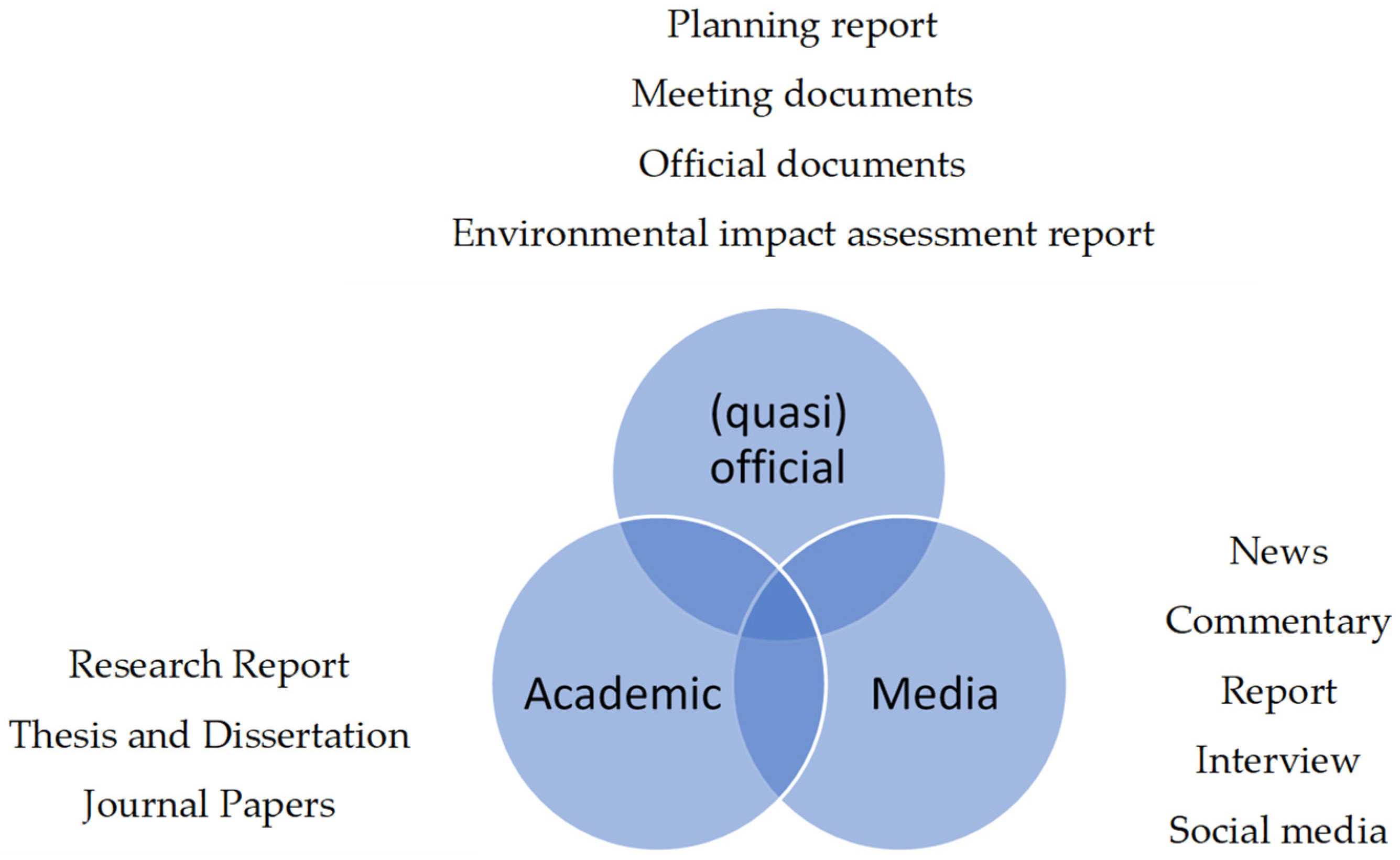
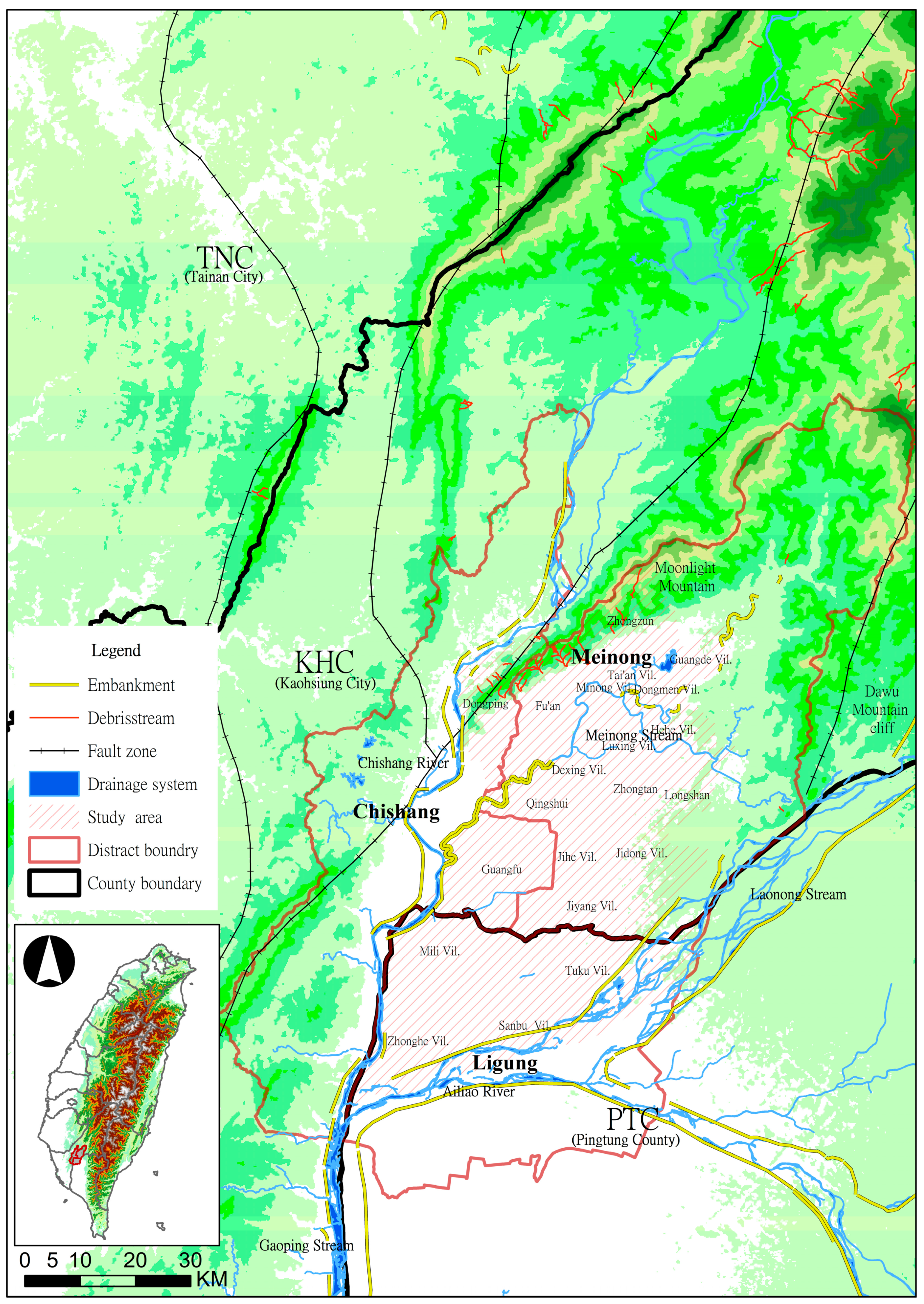
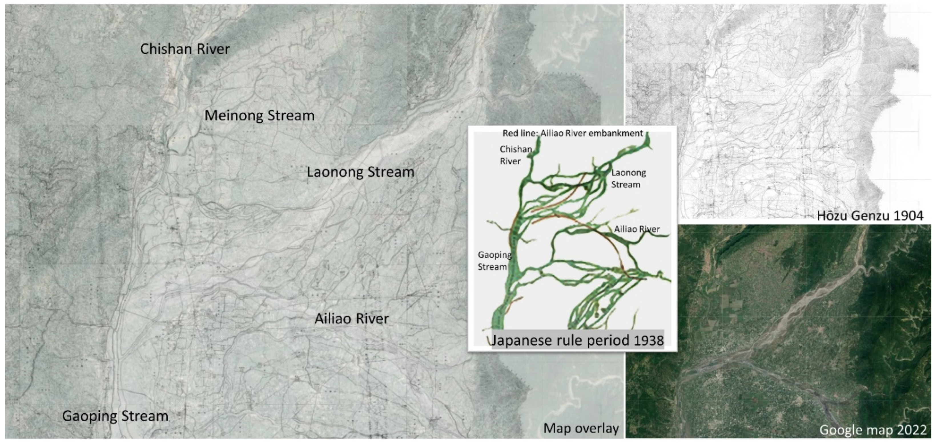
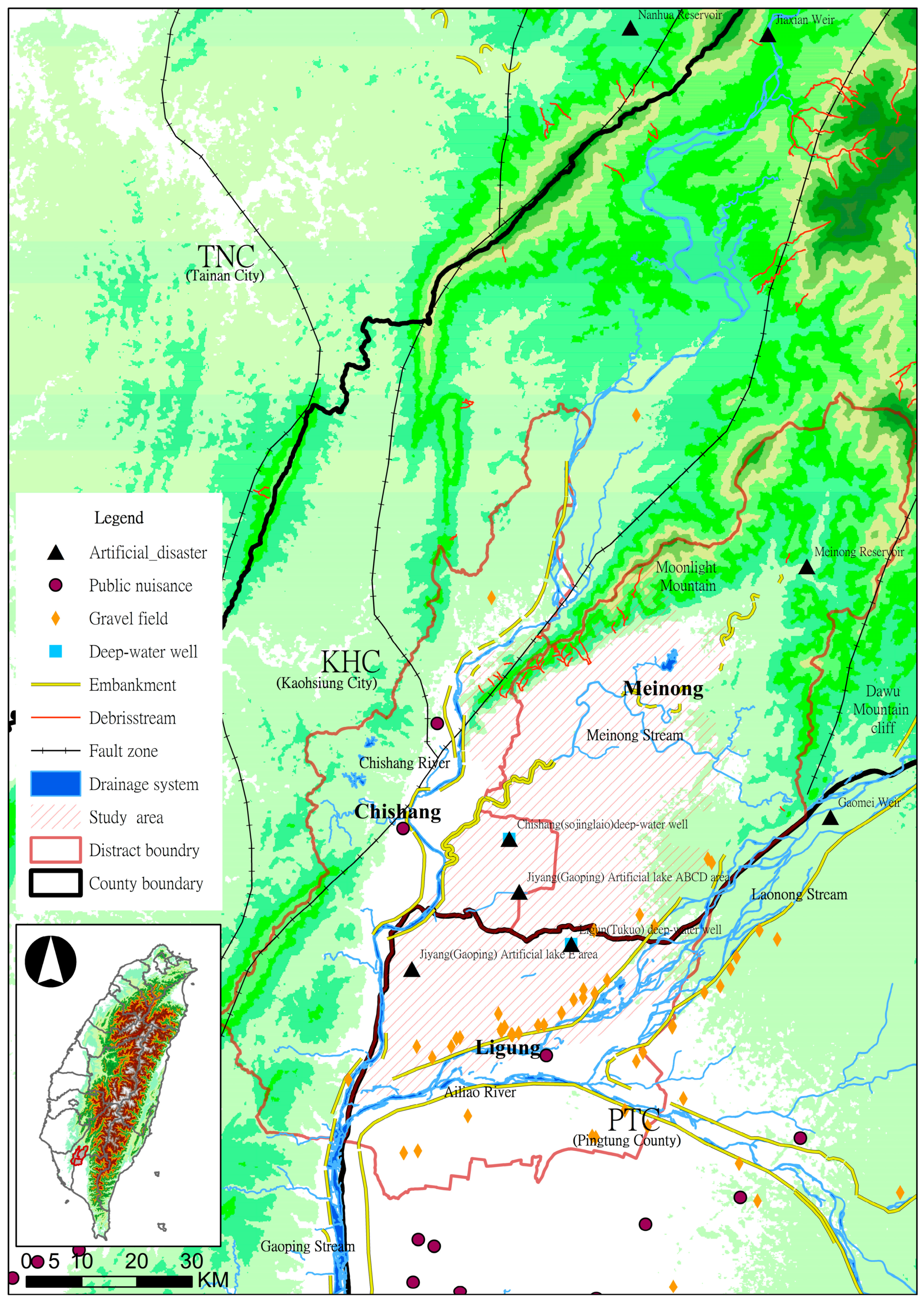
Table 1.
Population and ethnic groups in the study area.
| Name of Village | Population | Main Ethnic | ||
|---|---|---|---|---|
| District | ||||
| Meinong District | Hehe vil.; Luxing vil.; Zhongtan vil.; Dexing vil.; Longshan vil.; Guangde vil.; Dongmen vil.; Tai’an vil.; Minong vil.; Jidong vil.; Fu’an vil.; Zhongzun vil.; Qingshui vil.; Jiyang vil.; Jihe vil. (Total 15 vil.) | 28,359 | Hakka | |
| Chishang District | Dongping vil.; Guangfu vil. (Total 2 vil.) | 2786 | Hakka | |
| Ligung Township | Sanbu vil.; Zhonghe vil.; Mili vil.; Tuku vil. (Total 4 vil.) | 4549 | Hokkien and unnan–Burmese Veterans | |
Table 2.
Basic descriptions of five study cases.
| Case | Location | Related Parties | Claim | Situation |
|---|---|---|---|---|
| Waterway in Ching Dynasty | Meinong District, KHC |
| Survival and settlement | Settlement |
| Ligung Well Closure and Power Shut-Off | Ligung Township, PTC |
| Well closure and compensation | Complete well closure and monetary compensation |
| Anti-Meinong reservoir | Meinong District, KHC |
| Stop | Whole project is cancelled |
| Anti-Jiyang artificial lake | Chishang and Meinong District, KHC |
| Stop | Whole project is cancelled |
| Meinong anti-deep-water well | Meinong District, KHC |
| Stop | Project is on hold |
Table 3.
Five cases and community resilience.
| Five Cases | Water Tunnel in Ching Dynasty | Ligung Well Closure and Power Shut-Off | Meinong Anti-Reservoir | Jiyang Anti-Artificial Lake | Meinong Anti-Deep-Water Well | |
|---|---|---|---|---|---|---|
| Resilience Transformation | ||||||
| Learning change and uncertainty in disasters |
|
|
|
|
| |
| Water sensitivity nurturing diversity for reorganization and renewal |
|
|
|
|
| |
| Combining different types of knowledge for learning |
|
|
|
|
| |
| Release and reorganization |
|
|
|
|
| |
Publisher’s Note: MDPI stays neutral with regard to jurisdictional claims in published maps and institutional affiliations. |
© 2022 by the authors. Licensee MDPI, Basel, Switzerland. This article is an open access article distributed under the terms and conditions of the Creative Commons Attribution (CC BY) license (https://creativecommons.org/licenses/by/4.0/).
Share and Cite
MDPI and ACS Style
Tsai, S.-C.; Lee, S.-H. Disaster-Resilient Communities on Flood Plains and Their Agricultural Regeneration: A Case Study in Meinong Plain, Taiwan. Water 2022, 14, 1736. https://doi.org/10.3390/w14111736
AMA Style
Tsai S-C, Lee S-H. Disaster-Resilient Communities on Flood Plains and Their Agricultural Regeneration: A Case Study in Meinong Plain, Taiwan. Water. 2022; 14(11):1736. https://doi.org/10.3390/w14111736
Chicago/Turabian StyleTsai, Shu-Chen, and Su-Hsin Lee. 2022. "Disaster-Resilient Communities on Flood Plains and Their Agricultural Regeneration: A Case Study in Meinong Plain, Taiwan" Water 14, no. 11: 1736. https://doi.org/10.3390/w14111736
Note that from the first issue of 2016, this journal uses article numbers instead of page numbers. See further details here.