CDOT: Interstate 70 open in both directions in Glenwood Canyon

Colorado Department of Transportation

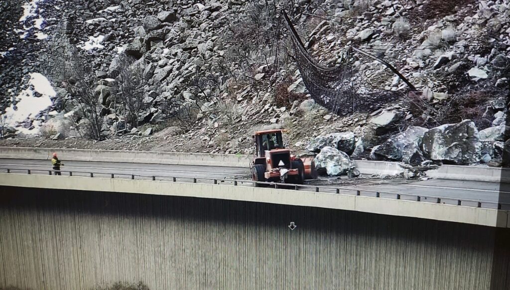
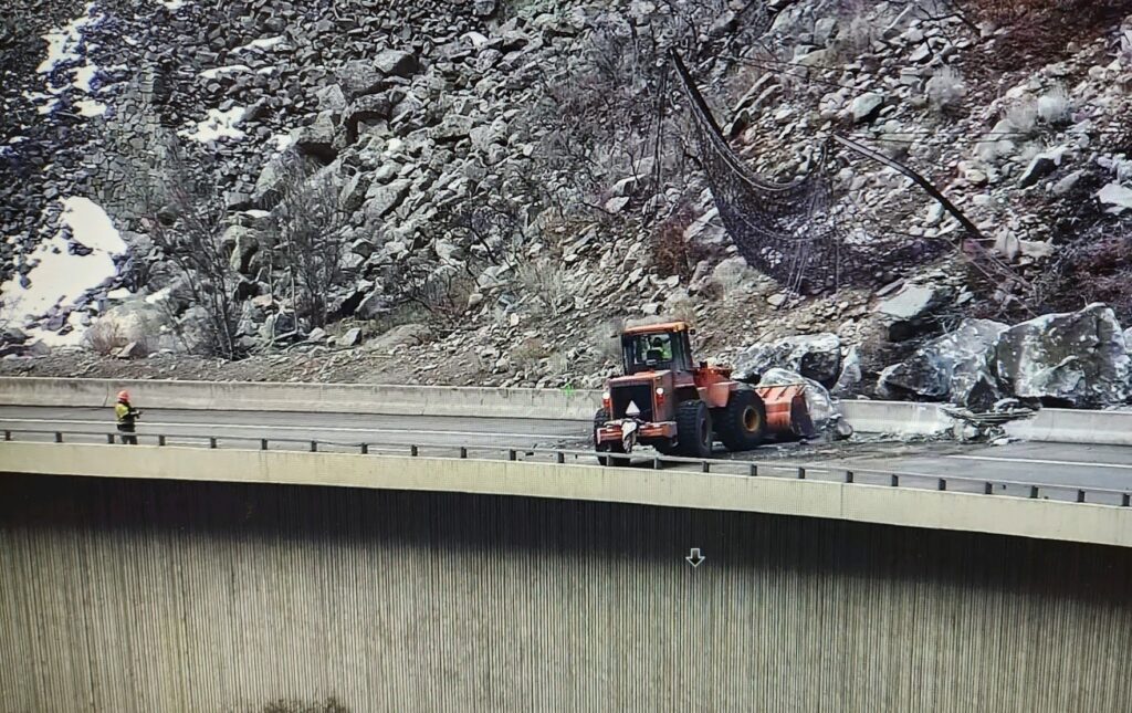
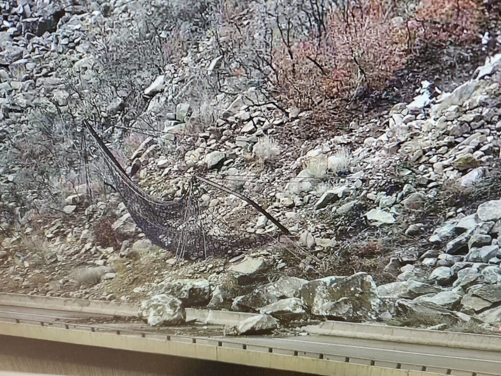
March 7, 11:32 a.m. – Statewide — Eastbound Interstate 70 in Glenwood Canyon has reopened after a safety closure, due to a rockslide at mile point 123.5. The slide came down onto the outside westbound lane. All lanes were closed as a safety precaution. One lane of westbound I-70 is anticipated to reopen shortly. CDOT’s Geohazards team is en route to further assess the slope above the roadway. 

The slide took place at approximately 10 a.m. this morning, and is located between Grizzly Creek (exit 121) and Hanging Lake (exit 125). The slide is located east of Glenwood Springs. See below for more photos. The slide is mostly rock. Crews immediately began clearing the slide with prepositioned equipment and are making good progress on clearing the roadway. CDOT anticipates crews will be able to quickly clear the slide from the roadway. An alternate route is not recommended at this time.

Rockslide on westbound I-70 Glenwood Canyon on March 7, 2024.

March 7, 2024, 11:36 a.m. – Interstate 70 has reopened to traffic in both directions.

March 7, 2024, 10:37 a.m. – Interstate 70 eastbound/westbound is closed due to a rockslide that occurred between exit 123 – Shoshone and Exit 125 – Hanging Lake. Road closed between MM 116 (Glenwood Springs) and MM 133 (Dotsero) expect delays

CDOT: Interstate 70 open in both directions in Glenwood Canyon

GSPD: Sopris Elementary lifted secure status

Glenwood Springs Police Department

2.16.24, 1:25 p.m. – the secure status has been lifted from Sopris Elementary. Emergency crews are still in the area of Parkwood Lane.

2.16.24, 11:36 a.m. – Sopris Elementary has been placed in secure for law enforcement activity in a nearby neighborhood. At this time the issue is contained to a specific residence on Parkwood Lane.

The secure status is a cautionary measure only.

Glenwood Police Department – facebook

GSPD: Sopris Elementary lifted secure status

Garco911: I-70 eastbound left lane closed at main Glenwood Springs exit

Garfield County Emergency Communications Authority

UPDATE 2.8.24, 8:32 a.m. – Today at 8:43 AM, Google reported a 5 min delay Eastbound. Between Exit 119: No Name and Exit 121: Grizzly Creek (1 mile east of No Name) from Mile Point 120 to Mile Point 120.5. The left lane is closed due to a crash. Slower speeds are advised.

2.8.24, 6:25 a.m. – I-70 is closed at mile-marker 116 eastbound, main Glenwood exit, due to an accident in Glenwood Canyon.

Garco911: I-70 eastbound left lane closed at main Glenwood Springs exit

I-70 closed eastbound: road closed mile markers 116-126 for pileup

Colorado Department of Transportation

12.8.23, 2:41 p.m. – Between exit 114: West Glenwood (Glenwood Springs) and Exit 129: Bair Ranch (7 miles west of Dotsero) from Mile Point 116 to Mile Point 126. Road closed expect delays due to a crash.

Comment: Pileup eastbound at Hanging Lake Tunnel. I-70 closed at Glenwood Springs.

Check CDOT cotrip for closures for updates when traveling.

I-70 closed eastbound: road closed mile markers 116-126 for pileup

I-70 reopened in South Canyon after crash

Glenwood Springs Police Department

I-70 through Glenwood Springs is completely open now. The collision scene has been cleared. Travel cautiously in the current severe weather conditions.

Colorado Department of Transportation

12-8-23, 11:39 a.m. – At Exit 114: West Glenwood (Glenwood Springs) at Mile Point 114.2. Road closed expect delays due to a crash. Slower speeds are advised.

Comment: Eastbound traffic being diverted around crash using the Exit 114 off-ramp and on-ramp.

12-8-23, 10:49 a.m. – Interstate 70 is closed in both directions in South Canyon between Exit 114: West Glenwood and Exit 111: South Canyon (Glenwood Springs) at Mile Point 114. Road closed expect delays due to a crash. Slower speeds are advised.

I-70 reopened in South Canyon after crash

Snow Pool: sign up for backcountry avalanche conditions

Colorado Avalanche Information Center (CAIC)

The Colorado Avalanche Information Center (CAIC) and the Avalanche Research Program of Simon Fraser University in Canada are building SNOW POOL, a community of backcountry users interested in providing feedback about their backcountry experiences and willing to review, share feedback, and provide suggestions about how to make avalanche safety information work better for everybody.

Who should sign up?

You do not have to live in Colorado or have any avalanche knowledge to participate. We are interested in the perspectives of all types of users with all levels of experience. We are especially interested in hearing from individuals who are just starting their backcountry adventures or only occasionally go into the backcountry.

What can participants expect?

Individuals who sign up will receive regular emails from CAIC and SFU to participate in short online user surveys and the opportunity to provide feedback on CAIC products and priorities. This is an opportunity to be part of a community that contributes to the development of improved avalanche risk communication, learn about CAIC research projects, and be eligible for incentive programs or entered into raffles hosted by some of our partners.

More information and sign up link are available online.
Snow Pool: sign up for backcountry avalanche conditions